• Happy National Apple Pie Day! 🍎🥧😋

May 2017 Bowron Lakes Solo

No Title

This 1st picture is looking east up the Cariboo River. This is where the clear waters of Isaac Lake meet the silty waters of the Cariboo.

The 2nd is heading down the river.
 

Attachments

  • photo6886.jpg
    photo6886.jpg
    241.3 KB · Views: 3
  • photo6887.jpg
    photo6887.jpg
    239.4 KB · Views: 3
Last edited:
No Title

I arrive at Lanezi Lake ( Lah neezy ). The weather starts to change.

There are really nice rock formations along the northern shoreline.
 

Attachments

  • photo6890.jpg
    photo6890.jpg
    197 KB · Views: 4
  • photo6891.jpg
    photo6891.jpg
    283.6 KB · Views: 4
  • photo6894.jpg
    photo6894.jpg
    548.7 KB · Views: 4
Last edited:
No Title

Wildlife alert! I saw this cute little weasel. I'm not sure what kind it is. It was searching around for food I guess and only looked at me a few times. In and out of the water like a little snake.

It's right in the middle of both pictures.
 

Attachments

  • photo6895.jpg
    photo6895.jpg
    198.7 KB · Views: 1
  • photo6896.jpg
    photo6896.jpg
    187.8 KB · Views: 1
No Title

I cropped the pictures a little. Man, my computer skills have really improved over the last 30 years. My brother was always having to show me what to do on our Commodore 64.
 

Attachments

  • photo6897.JPG
    photo6897.JPG
    1 MB · Views: 1
  • photo6898.jpg
    photo6898.jpg
    548.7 KB · Views: 1
No Title

This is how it was looking when I arrived at the Turner Creek shelter. I was pooped, a storm was coming, and the shelter here is pretty awesome. Finished the day at 3 pm.

This is looking south across the lake.
 

Attachments

  • photo6899.jpg
    photo6899.jpg
    210.7 KB · Views: 4
Last edited:
No Title

It rained most of the night, but was only a light rain when I departed Turner Creek. I was on the water at 7:30 this morning. I still haven't noticed any mice at night. Well rested and fed, I set off for another long day.
 

Attachments

  • photo6904.jpg
    photo6904.jpg
    156.5 KB · Views: 3
No Title

Moose! I was rounding a small point before an avalanche chute and there was this moose swimming towards me rounding the same point. It was only 10 feet in front of me. I reversed as it went ashore.
 

Attachments

  • photo6905.jpg
    photo6905.jpg
    191.4 KB · Views: 2
  • photo6906.jpg
    photo6906.jpg
    235.4 KB · Views: 2
No Title

I paddled to the end of Lanezi and into Sandy Lake. Usually low water causes a lot of walking here. Most of Sandy is about a foot deep and very sandy. The water on this trip is the highest I've ever witnessed. It makes everything a little better.

As I was entering Sandy a small rain storm moved in and I had to go through it, but then the sun came out for over an hour.

These pictures are looking behind at the rain and looking ahead to the sun.
 

Attachments

  • photo6909.jpg
    photo6909.jpg
    128.3 KB · Views: 2
  • photo6910.jpg
    photo6910.jpg
    161.2 KB · Views: 2
No Title

Lunch time on a sandy beach on Sandy Lake. I laid out some things to dry.

I purchased this jacket and pfd from Nookie in England last year. They have really nice stuff. You should check out their website.
 

Attachments

  • photo6911.jpg
    photo6911.jpg
    247 KB · Views: 4
  • photo6912.jpg
    photo6912.jpg
    144.8 KB · Views: 4
Last edited:
You probably think you are writing to yourself. I am reading.. So far I have learned how to rig a cart properly from your pictures. We will do the same circuit this September early in the month.
Do you have a map marked with stopping places each night?
So far I am amazed at the "beachiness" of it all, being used to Canadian Shield country canoe tripping.
 
Thanks for the trip report, I read about this loop about ten years ago and always wanted to do it. Now I want to do it all over again, maybe one day. Pretty expensive camping trip for me though. Maybe I'll do it after I finish paying for the kids going to college.
 
Of all my canoeing nightmares, it the uphill waterfalls that makes me lose the most sleep.

Great trip, other then that.
 
Thanks yellowcanoe. It can get frustrating if the cart is not held tight enough. Every bump or hole you hit will crank the cart sideways and cause the canoe to travel crooked and send you off the trail as you try to keep it straight. After screaming to the heavens, you straighten and tighten everything and carry on.

The park will provide you with an ok map but you can also purchase better ones. When it is really busy they actually assign you specific sites to stay at. Mountain Equipment Co-op has a nice double sided topo of the park that is waterproof for only 10 dollars. That's what I take with me. Also I always go when the park is closed so I never see anyone and when the weather is nice I just camp where ever I want. I don't usually use the bear caches or outhouses anyways. The shelters are nice sometimes though.

And yes, lots of nice beaches. With the lower water in September you will be seeing way more beaches than I did on this trip.

You should come by the blacksmith shop in Barkerville to say hello.
 
No Title

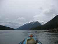
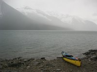
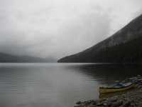
Thanks wysedav. A long ways for a week long paddle. It's definitely worth it though. I feel very fortunate to live a half hour drive from Bowron Lake. I even eat eggs from friend's chickens that live at Bowron Lake. I am planning to do the circuit again in the fall, a few weeks after yellowcanoe. I might be going with a friend who will paddle in another canoe. He recently moved here from England and is a hardcore cycle tourist, but I think I can get him into canoeing. I am not used to camping with other people, but he's a good guy.

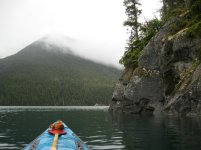
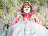
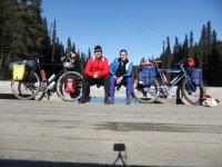
Here is a picture of us a few years ago doing a 3 day backcountry trip. Coincidentally, this picture is taken on a bridge right over the Cariboo River a couple of hundred kms south of Bowron Lake Park. I'm on the right.
 

Attachments

  • photo6917.jpg
    photo6917.jpg
    72.1 KB · Views: 2
Last edited:
Back
Top