• Happy Birthday, Liberace (1919-87)! 🤵🏻🎹🕎

West Branch Penobscot River and Chesuncook Village .. from a 1984 Yankee Magazine..

No one on the West Branch of the Penobscot river 2020

. Every campsite we saw was empty and the entire Penobscot River Corridor was used by three people. Of course it helped that someone left Seboomook Dam open this winter supposedly for work that did not happen and Seboomook Lake is just about dry. Hence the PRC is dry too. There are a few drags totalling a mile or so around Big Island and the reappeared again Pine Stream Falls which is really gnarly now.

We didn't run it. We really did not want to drag. We went to Lobster Lake for three nights and there was no one but us . We had our pick of 21 campsites.

On the logging roads there are occasional campsites. None of those were used either. The quarantine for residents of certain states is the issue.

Lovely 10 days away from the hellishness of everyday "civil" life.

We did drive to Chesuncook Village and chased a moose which of course left as I fumbled for my camera.. The road is decent but like all secondary forest roads has the occasional deep pothole so is Prius eating country ( we do not have a Prius for that reason) The Inn is in progress but no one is working on it.. It is just sheathed and Tyveked. It will be a while.

Really fun scouting out Pine Stream.. We may do a wander down that next month and return.. Looks like primo moosie country.

So timely! I am going to try to make a solo trip to Lobster in September (subject to COVID testing). By the way, I think rather than Pine Stream Falls, it should be called "Alan's Tent Falls (In)."
 
So timely! I am going to try to make a solo trip to Lobster in September (subject to COVID testing). By the way, I think rather than Pine Stream Falls, it should be called "Alan's Tent Falls (In)."

Oh no.. " Maine Bush Magic returns drowned tent to its owner Falls" ! This may sound so wrong but we did see people when we paddled in. A couple was doing a day trip and a picnic. The illusion was shattered. Of course this day trip involved a 65 mile trip over the Golden Road . I have no idea where that name came from. It was Deep Sand Road for us. "Dust Cloud Road. Cover Your Car with an Inch of Brown Sand that looks like crap" road. One section had been recently stoned with sharp stones. So of course I got a flat from a cut in the sidewall but this was just before the road to Baxter runs parallel.. We had been running around for some 200 miles on the Golden, Twenty Mile, PIne Stream/ Chesuncook Seboomook and Lobster Trip roads and had gotten away with a lot. Fate gave us the flat close to Millinocket.

We will be busy washing a vehicle and deep cleaning crevices of silt for at least a day . Crevices that never see the light of day. The drought does not help.

I am afraid Seboomook will not fill enough to restore a good flow to the river by September but we can always hope for you.

Re Lobster Lake where the stream enters. It has taken me some six trips now and FINALLY I know the secret to not getting grounded. There have been 11 errors. Hug the N Shore.

PS if you find yourself in need of anything from a store Raymond's at NE Carry is as well equipped as any store for necessities.They are open every day till six and I should have taken a pic of the inside of the store.NE Carry is a community of 110 folks ( probably seasonal) but the moose weighing apparatus is a joy to see.. The old couple ( they are in their 80's and going strong) are always there. Stop by and chaw even on politics. It is all civil and you get a view of perhaps a different lifestyle. I got involved in a gun discussion.

Thanks, Kim. This trip for me would be just down into Lobster for a few days —a Tour de Lobster — rather than the whole West Branch/Chesuncook route. Is the water level in Lobster reasonably normal? I’ll hope for some rain both to canoe and to make the roads less of a nightmare.

al
 
Al the levels in Lobster seem to be just a tad low .. as in just a bit .No sarcasm.. The chief effect is that swimming off the beaches in Ogden Cover requires a bit of walk to get into something over hip deep..

And the wind gods make a heck of a chop now even in just 10 knot breezes.

Last time we had red squirrel woes. Now we have a new canoe dog that hates water loves the canoe and kept every single red squirrel at bay. Also kept him occupied!
 
PS if you find yourself in need of anything from a store Raymond's at NE Carry is as well equipped as any store for necessities.They are open every day till six and I should have taken a pic of the inside of the store.NE Carry is a community of 110 folks ( probably seasonal) but the moose weighing apparatus is a joy to see.. The old couple ( they are in their 80's and going strong) are always there. Stop by and chaw even on politics. It is all civil and you get a view of perhaps a different lifestyle. I got involved in a gun discussion.

My gosh, the Raymond’s Store fella seemed kind of worn out when I visited in 2008. Didn’t see the wife, she was down in Bangor for a day or two. This was disturbing, because no wife to tend the store meant no shuttle for us, despite me having both phoned and written a letter to request shuttling. Wonderful they have been able to keep the store going, as there’s nothing quite like it and no other retail for a long way.
 
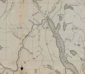
Back to "Alan's Tent Falls", I was map sniffing earlier and came across this one (Lucius Hubbard, 1879).

chesuncook_hubbard_1879_crop.jpg

FWIW, the rapid in question may in fact be Rocky Rips, if this map is correct and Pine Stream Falls is below the confluence with Pine Stream.

It's fun to look at the wee little Chesuncook, separate from Black, Caribou, Umbazooksus, etc.
 
That is a fantastic map.. I never realized there was a Pine Stream Falls. Rocky Rip was Als undoing.( and others too) It is fascinating to look at the trails on the map which must have been wagon roads.. No trace of them today with the enlarged lake! And no Gero Island on the map!
 
What a cool find!! Yes, I believe it was Rocky Rips that got me but I have to say, those rips were quite ripping that day. It was a chute with boulders.
 
... It is fascinating to look at the trails on the map which must have been wagon roads.. No trace of them today with the enlarged lake! And no Gero Island on the map!

Could they have been winter roads? It would have taken a lot of bridges and mud management to keep those open in summer.
 
Could they have been winter roads? It would have taken a lot of bridges and mud management to keep those open in summer.

Very likely.. And if there were bridges we would see some evidence. All we see is the pilings upstream for chaining log booms.
 
Back to "Alan's Tent Falls", I was map sniffing earlier and came across this one (Lucius Hubbard, 1879).

filedata/fetch?id=123495&d=1617503039

FWIW, the rapid in question may in fact be Rocky Rips, if this map is correct and Pine Stream Falls is below the confluence with Pine Stream.

It's fun to look at the wee little Chesuncook, separate from Black, Caribou, Umbazooksus, etc.

Goonstroke, thanks. That map is so cool I printed off a copy for my Maine files. Looking at the Pine Stream Farm, Ragmuff and Chesuncook and etc 1:24,000 topos the comparison is fascinating, and curious.

So Gero Island, Umbazooksus arm, Brandy Brook Pond and etc are the result of the raised pool level? Any idea when the lake level was raised?

Looking at the maps it appears that the pool level widening of the Penobscot extends upstream past Pine Stream, which jibes with my memories.

I thought “Rocky Rips” was the bit of fast water beside Big Island, not downstream of Ragmuff. Maybe the original Rocky Rip was backwater submerged and the name transferred to a rip upstream? I don’t recall any rip or even fast water near Rocky Branch above Pine Stream.

Or maybe Alan ran it when Chesuncook was very low, and he got to experience a “lost” rapid.
Yep, that's exactly what happened. It was a very low water level in September. (This year is shaping up to be even lower). The AGC people said they had never seen it that low.

The guy who found my tent, who is a very experienced paddler and who had paddled that before said he'd never seen those rapids and in his opinion they approached Class III. The next year I paddled it at a normal September level and it was a dead water.
 
Al et al.. Here is a video of this mornings Kenduskeag Stream Canoe Race.. Record low levels. Usually you have to bail not walk.
https://www.newscentermaine.com/arti...b-ba4efd905eec

You tube has many more videos of the race in normal or high water years..

Not boding well for poking around streams this summer.... sigh

Thanks, yellowcanoe. I watched that live, courtesy of FB. Six Mile Falls is normally a raging torrent. Today, more like a Slip 'n Slide. https://youtu.be/JvGH8n0_-pw

When boats overturned coming down the falls this year it was comical watching the "rescuers" bombard the "swimmers" with throw bags, only to have the "swimmers" stand up in the (barely) ankle-deep water.

I agree that it will be a bad year to be paddling some of Maine's iconic rivers and streams unless Maine gets a monsoon or two.
 
Looking at the maps it appears that the pool level widening of the Penobscot extends upstream past Pine Stream, which jibes with my memories.

The pool level was raised at least twice (and perhaps a few more times in between). The original dam(s) were surely for holding back water to aid in the log drives. The old dam was at the foot of Chesuncook proper (before Ripogenus lake) and can be seen at extreme low water. From memory, Thoreau talks about trees killed from inundation and describes a shoreline consistent with a dam, so the original dam was i place before the mid-19th century. However, this dam was small and didn't create the lake as we know it today. (Witness the lack of Gero Island, Umbazooksis Lake, etc.on Hubbard's map above.) The current size of the lake was defined by the Ripogenus dam, completed around 1920 and converted to produce power not long after that.

I've been interested to see Rocky RIps and Pine Stream falls for years. Some of the historic travelogs mention them including Thoreau (The Maine Woods), Steele (Canoe and Camera), Stanton, and Hubbard. You also see them mentioned in many of the old guide books (e.g. Hubbard and early Bangor & Arrostook Railroad guides). You can find many on archive.org The conditions that expose Rocky Rips and Pine Stream falls have more to do with the amount of water held back by Rip Dam rather than Seboomook Dam. Though these things are often closely correlated on dry years.
 
Back
Top