"Once the principal route between the upper Aroostook and the East Branch [Penobscot River], this carry was direct, and useable as long as streams were unfrozen. The southern half of the Millinocket Carry is abandoned and a challenge today ... It is a major loss."
- Ron Canter, The Allagash and its Neighbors: Canoe Trails, Past and Present, Joining the NFCT to the Major Rivers of Northern Maine*
As soon as I began reading this guide from Canter I knew that I had to attempt the Millinocket Carry. It has all the ingredients for a rewarding trip: solitude, history, scenic beauty, physical and navigational challenges. I've always enjoyed canoeing as a means of wilderness travel, in contrast to activities that only work downhill or downstream. Here is a connection that was once among the most significant in Maine, along with the Northeast Carry, Mud Pond Carry, etc., and it's now essentially forgotten to all but a handful of canoe trail history nerds.

The Millinocket Carry on a map of 1883 (Lucious Hubbard)
As a practical matter, the area of the Millinocket Carry is within range of a long daytrip from my home in Bangor, making some pre trip scouting possible. I did that scouting in late summer 2021. The crossing from the East Branch Penobscot to Moose Pond is about four miles total, consisting of forest road walking, marsh / beaver pond paddling and over a mile of trackless bushwhacking.
No dates were open for a fall trip, so over the following winter a friend and I made plans for mid May.
Day 1: Grand Lake Matagamon and up the East Branch to Turner Brook.
My paddle partner for this trip, Hope, is a long time canoe tripping buddy and experienced backpacker. (She also happens to be a bona fide cartographer -- I'm only an amateur map nerd.) I'd been paddling whitewater all spring and she'd been hiking and running, so with maps, GPS waypoints and light(ish) packs, we felt pretty ready for a challenging trip.
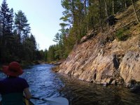
After driving up to the area and shuttling cars, we got on the water at about 1pm, starting from the boat launch at the Baxter State Park north entrance. The weather was warm and the wind calm, actually too calm for comfort, but given the size of the lake we didn't complain. Grand Lake Matagamon was originally two lakes which were connected when a dam raised the water level. We paddled toward Second Lake, the western arm, where both Webster Stream and the East Branch of the Penobscot enter. Most of the lake is part of Baxter State Park, and the campsites were well manicured. We stopped at Pine Point on Second Lake for a late lunch, and enjoyed the view south to the Traveler and the northern mountains of Baxter.

A Penobscot 16 headed up the Penobscot
We saw a couple of fishermen in a small motorboat near the inlet; they waved hello and didn't ask us where we were going, which is fine, it would have taken some explaining. Just above the lake we passed the confluence with Webster stream and continued to the right up the East Branch proper. Given the Telos Cut, Webster is the greater river now. We were surprised how little water there was in the (mighty!) East Branch, it being May, but there was enough to float us most of the time. Although we were only about 4 river miles from our goal for the day, we knew we had a lot of work ahead of us. The river drops about 50 feet in this section, including rock formations similar to nearby Webster Stream's Grand Pitch.


In the boat when possible; No carbon paddles for rocky upstream
Above the Webster confluence, the East Branch descends through a series of discrete drops (I counted 6 of them) before reaching a deadwater. We worked our way up the stream methodically, paddling, tracking or wading as necessary (n.b., I didn't bring a pole, didn't want to portage it). One drop (#5 by my count) was particularly thorny, and we got out on our right (river left) to scout. The most scenic spots are usually the hardest to traverse. Eventually we found a stretch of old road on that bank, and used it to make a ~150 yard portage, trimming some alder to get back to the water's edge. (As an aside, I find pruning shears are the most useful tool to a bushwhacking canoeist.)

The glamour of portaging in blackfly season
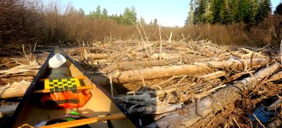
After reaching the deadwater, we had an easy but short paddle to a large log jam. We knew this was coming since it's quite prominent on aerial imagery. Of course the water was deep and all of the logs were floating -- where did I put my peavey? We dragged along a side channel for a while but then just pulled out our packs out of the boat and dragged it over the logs.
.jpg")
Log jam, I'm smiling because it's done and I'm about to get back in the boat
Above the log jam the smoothwater continued for a time, but gradually the river became steeper, necessitating more wading. Unlike the lower section which was mostly pool & drop, this was more like a long incline. Eventually we began to see rock instead of mud on the banks, and thankfully the first big ledge was our destination for the day.
We arrived at camp around 6:30. A note about travel times. My thumb rule for upstream travel without established portage trails is time for the distance (e.g., 1 hour for 4 miles), plus one hour for every 20 vertical feet of ascent. That would have been 3.5 hours in this case, and we were in that ballpark.
Although a secenic spot, the "campsite" at Turner Brook was not exactly posh. A sloped rock next to a ledge drop (class 3?) was the primary feature. It was pretty, but you couldn't cook there or you'd risk something rolling down into the water. There wasn't much room in back for tents, although we managed to find spots on thick moss -- lumpy and not at all level, but very soft. Since I'd remembered this place as a great campsite and perhaps oversold it to my tripping buddy, we called it Dubious Campsite, and the ledge drop Dubious Campsite Ledges.
Note: I'm not sure of the name of the brook. One map (photo above) appears to say Turner Brook, another Bog Brook, and most don't mark it at all since it's quite small. There are too many Bog Brooks so I'm going with Turner Brook. Turner Brook flows into the East Branch at Dubious Campsite Ledges, and at that point there is/was/really should be a "trail" (also dubious) heading north.
I'd previously reached Dubious Campsite from upstream in a scouting daytrip last August (that day was a skidplate stress test). I had a full-on religious experience when I saw this sign, since it confirmed that the site had been popular sometime in the 20th century and was almost surely the anchor of the historic portage trail.

The tree holding the sign was one of three huge white pines in or near the campsite, all wolf trees.
We found no fire ring, and given the thick pine duff and dry conditions, we took the sign's advice and made our dinners on camp stoves.

Wet socks removed, time for dinner
We ate up and retired to our tents, satisfied with our progress for the day. We were wise enough not to say it, but the day had basically gone according to plan. Tomorrow we would begin the portage.

*This guide is unpublished and distributed informally. PM me your email and I'll send you a copy, or ask Karrie at the Northern Forest Canoe Trail, email at the bottom of this article. https://www.northernforestcanoetrail.org/adventuring-off-the-beaten-trail-with-ron-canter/
.jpg")
.jpg")
.jpg")

.jpg")

.jpg")


.jpg")

.jpg")


.jpg")
.jpg")