G
Guest
Guest
One if my favorites is the big, bad New River. The name is ironic because it's second in age only to the Nile. Starting somewhere in NC and passing thru VA, it absolutely flowers here in eastern West Virginia. The fishing is very good, the access reasonable, and it's never crowded. The scenery is first rate and compliments the many sites of historic and prehistoric interest. There's hiking and camping botanizing and birding, boating and loitering around in the woods and fields and along the river and its tributaries.
I like the the section between the Hinton dam and the Va line, a stretch on the order of 15-20 miles. Below the dam the river get pretty steep, so be prepared for CLASS II-IV. Above it's mostly flat with ledges every couple of miles. A few of these will put you thru CLASS III briefly, but they are easy to scout, and guide books can tell you exactly.
Last month I approached the mouth of a channel a few mile below the VA line. During my shoreline creep I pushed a bald eagle out of its perch high in a stream side sycamore. Not too shaken up, it rowed upstream a few hundred yards to mount into the top of another sycamore on the far side of the channel mouth I was aiming at.
150 yds off and I found myself, as well as the eagle, looking at a lot of splashing in the channel mouth. I could not make anything out of it, but the eagle was completely absorbed by the goings on directly below. Now oblivious of me, its neck was arched at a peculiar angle as it craned its head over for a good look. If you've seen a robin on your lawn giving a worm "The Look", you know what I mean.
When the splashing stopped the eagle resumed its characteristic severe dignity and flew away up river. A long way this time.
I was not satisfied and came in slow. In a few minutes 2 otters broke the surface in the middle of the main stem as I held in the channel mouth. They were 50 yards off my port bow. As startled and curious to see me as I was to see them, they "stood up" in the 15' deep flow to get a better look. That is, they were treading water and emergent about up to the middle of their rib cages. I wish that I could do that. Some times one, sometimes both at the same time.
Because I use pocket cameras with short focal length ranges, I don't get excited by the possibility of wildlife pictures. "About to be run over by a flock of enraged turkeys" would give me a chance. But something made me want to return the personal gesture of these two.
The problem was that as soon as I put down the paddle to go for my camera, the fast current lost me 25 yards and turned me 90 degrees away. I had one shot and it was close to being over my left shoulder. I got it.
The pair vanished. I watched for 5 minute over water that was open and flat for a very long way. Not a ripple. You've got to admire them.
Hello to Chethro, another West Virginian, over near Oak Hill. I like the looks of that lake. I could try it. The cove looks secluded and reminds me of my best bass pond where I grew up in eastern MA.
And to RavenWolf: I'm glad that you liked the review. Sometimes I use my pictures in support of a few efforts to protect natural areas around here. Mostly I do them to amuse myself. And I'm too unfocused to show. This is about my speed.
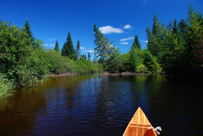
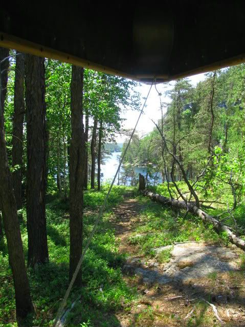
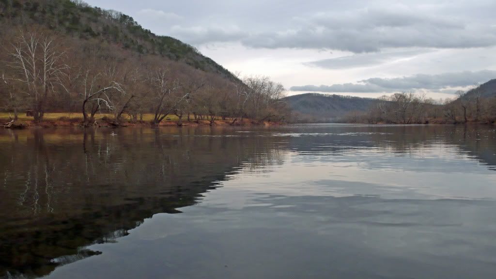
That's one of those rascally otters hot dogging in the left midground. The open ground in the left background is a state park camping area. A relaxed and lightly used RV type place that is well maintained and always decorous. In early historic and prehistoric times it was a well used Indian campground. Across the river is a village site last occupied in about 1500.
I like the the section between the Hinton dam and the Va line, a stretch on the order of 15-20 miles. Below the dam the river get pretty steep, so be prepared for CLASS II-IV. Above it's mostly flat with ledges every couple of miles. A few of these will put you thru CLASS III briefly, but they are easy to scout, and guide books can tell you exactly.
Last month I approached the mouth of a channel a few mile below the VA line. During my shoreline creep I pushed a bald eagle out of its perch high in a stream side sycamore. Not too shaken up, it rowed upstream a few hundred yards to mount into the top of another sycamore on the far side of the channel mouth I was aiming at.
150 yds off and I found myself, as well as the eagle, looking at a lot of splashing in the channel mouth. I could not make anything out of it, but the eagle was completely absorbed by the goings on directly below. Now oblivious of me, its neck was arched at a peculiar angle as it craned its head over for a good look. If you've seen a robin on your lawn giving a worm "The Look", you know what I mean.
When the splashing stopped the eagle resumed its characteristic severe dignity and flew away up river. A long way this time.
I was not satisfied and came in slow. In a few minutes 2 otters broke the surface in the middle of the main stem as I held in the channel mouth. They were 50 yards off my port bow. As startled and curious to see me as I was to see them, they "stood up" in the 15' deep flow to get a better look. That is, they were treading water and emergent about up to the middle of their rib cages. I wish that I could do that. Some times one, sometimes both at the same time.
Because I use pocket cameras with short focal length ranges, I don't get excited by the possibility of wildlife pictures. "About to be run over by a flock of enraged turkeys" would give me a chance. But something made me want to return the personal gesture of these two.
The problem was that as soon as I put down the paddle to go for my camera, the fast current lost me 25 yards and turned me 90 degrees away. I had one shot and it was close to being over my left shoulder. I got it.
The pair vanished. I watched for 5 minute over water that was open and flat for a very long way. Not a ripple. You've got to admire them.
Hello to Chethro, another West Virginian, over near Oak Hill. I like the looks of that lake. I could try it. The cove looks secluded and reminds me of my best bass pond where I grew up in eastern MA.
And to RavenWolf: I'm glad that you liked the review. Sometimes I use my pictures in support of a few efforts to protect natural areas around here. Mostly I do them to amuse myself. And I'm too unfocused to show. This is about my speed.
That's one of those rascally otters hot dogging in the left midground. The open ground in the left background is a state park camping area. A relaxed and lightly used RV type place that is well maintained and always decorous. In early historic and prehistoric times it was a well used Indian campground. Across the river is a village site last occupied in about 1500.