• Happy National Audubon Day! 🐣🐦🦅🕊️

South Nahanni River, Northwest Territories

Thanks, Alan. I have read that you are only 40 years old, perhaps not old enough, depending on your preferred music genre, to know about the Canadian rock group Bachman Turner Overdrive, otherwise known as BTO. In their words, "You ain't seen nothin' yet."

Just you wait. The scenery only gets more spectacular.

Looking forward to it!
Erica
 
Mem,

Posting that link to the youtube video was diabolical. That song has been stuck in my brain all day long!

Anyway, back to the story.


nahanni067.jpg
Our apprehension about a more travelled route was unfounded. Another glorious morning (the 12th day), at Hellroaring Creek. A moose had swum across the river into our breakfast camp, and all was still well with our world, in its comparative solitude and isolation.


nahanni068.jpg
Leaving Hellroaring Creek. Virtually no signs of human activity exist on gravel bars because of the cleansing action of spring floods.


nahanni069.jpgI'm taking the picture. Andy is far right.

During lunch, we revised our plans in order to reach Virginia Falls by 7:00 p.m., rather than stop 30 km (20 miles) short, as originally planned. This provided an extra layover day, and avoided camping in the dense brush on the banks of the very slow moving river. Seemed more lake-like than river-like.


nahanni070.jpg
Kathleen standing next to our canoe. Designated campground at Virginia Falls, the focal point of Nahanni National Park. The Park Service caters to canoeists, as evidenced by this canoe rack adjacent to the river. Very convenient.


nahanni071.jpg
To protect the vegetation, boardwalks provide access to approximately 70 designated sites, which are filled on weekends during July, from not only canoeists, but also flights from Fort Simpson or Fort Liard. There was only one other couple in camp when we were there in the third week of August, and they were on the other side. While Andy, John and Grace went hiking on Sun Blood Mountain, I decided to take a bath. I heated up some water, and undressed. Just then, a helicopter rose up over Virginia Falls, flew over the camp, and banked right above me. I was sure I could see tourists clicking away on their cameras!


nahanni072.jpg
The boreal forest flora, dominated by moss, lichen, and ericaceous plants is rich and varied. Shown here with the mushroom is northern commandra and northern Labrador tea (the taller plant).


nahanni073.jpg
The moss is already turning red, as was the bearberry (very red), rock cranberry (note the two red berries), and bog rosemary (to the right).


nahanni074.jpg
Because of human concentration at Virginia Falls, food caches are also provided, primarily to protect from bears. It turns out, though, that nothing is secure against ravens.


nahanni075.jpg
The portage trail to the base of Virginia Falls is 1.2 km (0.7 miles). When we were there, about half was boardwalk and half was well-maintained trail. This boat belonged to a German couple on their second trip down the Nahanni River.


nahanni076.jpg
We were just on a day hike to the base of the falls when we came across piles of their gear. Might as well be helpful, we thought, and we picked up their parcels and continued down the trail. They were joyous when they saw us. Gave us candy bars and hugs. They tripped with lots of small parcels, and both of them had to make 6 trips down the portage trail. Kathleen and I became good friends with Gunther and Christa. They came tripping to Canada every second year, and always visited us in North Vancouver. We even spent a week with them on their small farm south of Hamburg.


nahanni077.jpg
The portage trail offers excellent vantage points for Virginia Falls, which is really two falls (91.5 m and 55 m; 298 feet and 180 feet) separated by a central stack. By comparison, Niagra Falls is a paltry 51 m (167 feet).

The name Virginia Falls is for Virginia Hunter, daughter of Fenley Hunter, who explored the region in 1928 for the Geological Survey of Canada. The Dene name Na'ili Cho means "big water falling down."


nahanni078.jpg
Looking down 5-mile canyon. This canyon has been formed by the gradual recession of Virginia Falls, occurring at approximately 1.0 cm/year (less than half an inch)

.
 

Attachments

  • nahanni074.jpg
    nahanni074.jpg
    551.5 KB · Views: 0
Last edited:
nahanni079.jpg
At the base of Virginia Falls, the weather is extremely wet and foggy, but impressive beyond the soundless characteristics of this image. Gastropod fossils abound at the base of the falls.


nahanni080.jpg
Kathleen above Sluice Box Rapids, which thunders toward the Central Stack.


nahanni081.jpg
We spent much of our time enjoying just being by the falls. We felt an affinity with this river. We had been there when it was born at the Moose Ponds, when there was barely enough water to float a canoe. And now we shared its power as it thunders over the precipice.

I wasn't shaving on this trip, and for the first time in my life grew a beard. I shaved it off in 1998, just before we went to spend the winter in that one-room cabin on the shores of Colville Lake.


nahanni082.jpg
We fantasize what the run would be like, visualizing safe routes through downstream v's and into eddies just above the brink.


nahanni083.jpg
The falls can be heard at least 0.5 km (0.3 miles) upstream, and the Park Service has a sign warning to take out. Although the river is more like a lake, Sluice Box Rapids does rise instantly, with egress virtually impossible after the initial 3 m (10 feet)!


nahanni084.jpg
The portage take-out is immediately above the rapid. We approached right up agains the bank, ready to grab willow branches if need be. A mistake that would result in certain death certainly grabs ones attention.


nahanni085.jpg
Kathleen and I took 2 trips each on the portage, lasting 1 hour 10 minutes. We had two large packs for food and clothing (25-30 kg; 60-70 pounds each), one medium pack for sleeping bags and pillows, and 1 plastic bucket for fresh food and odds and ends. And of course, the canoe.

Some information that we had read said that Five-mile Canyon has strong water and large waves throughout. A capsize usually resulted in a swim through the entire canyon. We decided to wear our wet suits.


nahanni086.jpg
It did look a bit ominous.

Before our trip, our group met two times to discuss the general trip objectives. I had prepared the tentative itinerary, and mentioned that the four canyons below Virginia Falls were the major attraction for Kathleen and me. I pointed out that the itinerary for the upcoming paddle below Virginia Falls was for 8 km (5 miles) to Marengo Creek, just at the end of Five-mile Canyon. I pointed out both times that this would take us less than one hour, but that's what we wanted to do. The group agreed with us at both meetings.

Now cue the drum roll, for what happened at Marengo Creek. Some of you have probably been expecting something like this.

We arrived lickety-split, and started unpacking our canoe. I turned around to see that John and Grace had not moved from their canoe. John said, "It's not worth it to have packed up everything to paddle only one hour. I think we should take a vote to continue paddling, so that we can get to better places for hiking. I don't want to stay here."
 
Last edited:
A Fine way, to spent a Snowy Saturday night ! Thanks !
I can wait for "The Rest of the Story !" quoting Paul Harvey here :rolleyes:

Jim
 
You tell a great story, and the introduction and background to this chapter in your life was particularly good, but I'm doubly impressed with the photography and how it makes the trip reports especially complete. Many of your shots are spellbinding, and those together with those less scenic add up to a wonderful narrative.
 
Wow! Some awesome trip memories and amazing photos. An epic trip read...and a cliff hanger. Looking forward to finding out what happens next!
 
So, we left off last time with John and Grace not getting out of their boat at the spot we agreed to stop at two previous trip planning meetings. John said, "It's not worth it to have packed up everything to paddle only one hour. I think we should take a vote to continue paddling, so that we can get to better places for hiking. I don't want to stay here."

"But Kathleen and I don't want to rush through this part of the trip, John."

Carey said that "We need to have a discussion."

"I don't need to have a discussion. I vote to stay. I'm pretty sure that's how Kathleen will vote."

I was pretty irritated, and walked off into the bush to compose myself. What to do? I don't know how Carey and Janice will vote. But I'm going to stay, no matter what. We only have one major challenge ahead of us, at heck's Gate, and there is a well-defined portage trail.

Each couple is responsible for their own breakfast and lunch. So they are set for that. We are taking turns cooking supper for the group. I'm pretty sure that there are six scheduled nights left on the trip. So, Kathleen and I have two suppers left, both of which feeds six people for one night. That means we have 12 person-nights of suppers. That's all we need. Two people. Six nights. Twelve person-nights. Perfect. Our companions are also similarly supplied. That means we are all self-sufficient. Each couple is also carrying one extra supper for group emergencies. We have more than enough food. I can give them our emergency supper if they want. If Kathleen and I run short, I can always catch a fish. My mind was made up. Kathleen and I are staying. I returned to the canoes were the discussion had ended.

Carey, Janice, Kathleen and I voted to stay. John voted to leave. Grace abstained. Andy didn't get a vote.

So that's good; but I didn't feel very happy about.


nahanni087.jpg
The next morning all seven of us drift down to heck's Gate, only 10 km (6 miles) away. Thinking about this incident nearly 29 years later, I am wondering how it might have all transpired. Andy, John and Grace had spent the previous day hiking on Sun Blood Mountain. Andy was an avid hiker, and I think John and Grace were also. They know that the itinerary called for only one more rest day, which would accommodate hiking. I'm now thinking that they wanted to speed up to get an additional rest/hiking day. If so, why didn't they just go on their own? They didn't need us. John and Grace made a stronger tandem boat than Kathleen and me. Why didn't they just go on their own? Why put the group through that turmoil? Oh well.

Andy had begun paddling only in March, and had waited for us on the river, because of Five-mile Canyon and heck's Gate


nahanni088.jpg
heck's Gate Rapid, also known at Figure 8 Rapid. The following is a quote from information we had about the rapid.

"heck's Gate contains the best known and most difficult rapids on the South Nahanni. At the start of the rapids, the river turns to the right and comes up against a cliff face, crating irregular standing waves of up to 1.5 metres (3 - 6 feet) in height. The channel then makes a sharp, left angled turn, and enters a short gorge. The current, however, doesn't make the turn and continues across the channel to pile up against a rock wall. Large eddies are thereby created on either side of the main current. At high water levels, even experienced paddlers are required to portage here. Since these rapids vary in difficulty from Class 2 to 4, all canoeists must exercise good judgement when deciding whether to run them or not. The short portage trail runs along the right bank and provides an excellent vantage point to scout the river."


nahanni089.jpg

From the portage trail, Kathleen and I decided to run. Our entire group decided to run. In fact, we had now been joined by the Germans, Gunther and Christa, whose camp we stopped at just upstream from heck's Gate. Carey said that if they packed up quickly, he and John would run their canoe through for them.

The rapid really required only one move. Paddle out to get tight up agains the cliff face on river left. Then power across at the point before the wave train got too big.


Nahanni128.jpg
I haven't seen this image since 1990, because it was way over-exposed. But with Google Photos I was able to darken it. I wasn't worried at the time. But maybe I should have been.


nahanni090.jpg
Andy setting up well, but should perhaps be a bit closer to the cliff face.


nahanni091.jpg
Almost missed that eddy! Andy said he was happy to "cheat death yet another day." When we were all through, Gunther and Christa rewarded every one with a candy bar, which was richly appreciated. Kathleen and I had not taken any snacks, which was a mistake we never made again. On all subsequent trips we have taken dried fruit, and a daily bag of a gorp mix prepared by Kathleen.


nahanni092.jpg
We are now in third canyon, as named by those early explorers, trappers, and gold seekers who came upstream from Fort Simpson. The Nahanni offered a difficult route to the Yukon during 1898. One such individual wrote his last note, nailed to a tree: "heck can't be worse than this trail. I'll chance it." With that, he shot himself. The Nahanni itself was also the site of gold fever and rushes periodically until the 1930s.


nahanni093.jpg
Third canyon is impressive, with long, colluvial slopes of shales and sandstones, dating back to the pre-cambrian, 4,600 million years ago, when the area was a vast inland sea.


nahanni094.jpg
Carey's canoe. All of our subsequent canoes have been red, rather than green. Red seems much more photogenic.


nahanni095.jpg
We are now at "The Gate) in Third Canyon (Not to be confused with heck's Gate). The river narrows, and makes a sharp right-hand turn, yet remains calm, without rapids or standing waves, suggesting how deep the channel must be.


nahanni096.jpg
On the downstream side of the gate, with Pulpit Rock, one of the most photographed features. The Nahanni used to flow on river left, but found a crevice on what is now the main channel, flowing underground until the bridge across the channel collapsed, leaving Pulpit Rock.
 
Last edited:
nahanni097.jpg
Down Third Canyon. In 1978, Nahanni National Park was formally dedicated by the United Nations Educational, Scientific, and Cultural Organization as a world heritage site - the first natural area so named. A plaque at Virginia Falls reads: "Nahanni National Park...contains outstanding examples of the major stages of the Earth's evolutionary history and of significant ongoing geological processes..."


nahanni098.jpg
Geographers describe the South Nahanni as an antecedent river, meaning thereby one which preceded the mountains. Before mountains were created in this area, the South Nahanni meandered across a wide plain. When rock uplifts occurred, the river maintained itself by cutting down through the rising rock strata. This resulted in the formation of several canyons which scientists believe were formed about 1.4 million years ago. The great curves in the canyons were crated by the entrenchment of the meandering channel.


nahanni099.jpg
Kathleen in Second Canyon, with cliffs more vertical because of a higher proportion of limestone rather than shales and sandstones. These canyons were a major attraction for us.


nahanni100.jpg
Carey put our trip on videotape, aided with a solar re-charger.


nahanni101.jpg
We are now in Deadmen Valley, between Second and First Canyon. So-named because of the death of Frank & Willie McLeod who were found dead in 1908, after venturing into the Nahanni in 1905 in search of gold.


nahanni102.jpg
Their bodies were allegedly found here at the head of Deadmen Valley, just below Second Canyon, at Headless Creek, so-named because the brothers were discovered minus their heads, and according to legend, tied to a tree, presumably murdered for their discovery of a vast and still lost gold mine.


nahanni103.jpg
Here on this bench in Deadmen Valley, at Sheaf (Wheatsheaf) Creek is where R.M. Patterson built his cabin, from where he trapped for furs and search for gold with his partner Gordon Matthews. Patterson ventured up the Nahanni twice, in 1927, and 1928-29, and his book "Dangerous River" dispelled the prevailing myth of the Nahanni being a river from which no man or woman ever returned. Looking across the Nahanni to Prairie Creek, with excellent, leisurely hiking.

It was Grace and John's turn to prepare supper, here in Deadmen Valley. Our rule was that the couple preparing supper got to pick the campsite. John said he wouldn't stay at a place with a picnic table, so we all continued paddling down river.


nahanni104.jpg
We soon reached the end of Second Canyon, and I caught up with John and Grace.

"John. The best hiking remaining on the trip is here in Deadmen Valley. We'll soon be out of it. It's your choice, but I think we should head back up if you really want good hiking."

Here we are tracking back up.

That night, over dinner, for the second time in a row, Grace was obviously dishing out larger first and second servings to John. When asked about it, she said, "The meals you guys are preparing are too small. John is hungry."

I didn't mention anything, but John and Grace were responsible for 7 of every 9 of their meals. Hardly fair to blame us.

Carey later told me that he found out that John had eaten the emergency food in his pack. Perhaps he considered his hunger to be an emergency.


nahanni105.jpg
On the rest day, Kathleen and I did a little bit of hiking, but mostly just hung around camp, doing a little reading. In the evening we were entertained by 3 beavers, a mother seemingly giving swimming and tail-slapping lessons to her offspring in the adjacent back-eddy.


nahanni106.jpg
Although I lost 5 lbs (2 kg) on the trip, I didn't ever really feel hungry. We all dried our own food, with our meals typical of the fare: Tuna Casserole; Chile with Chick Peas; Spiced Lamb Stew & Dumplings; Szechwan Beef & Vegetables with Rice. Att Virginia Falls we enjoyed canned ham with fresh potatoes and carrots. On there night to cook, Janice often prepared strawberry shortcake, made with dehydrated strawberries, dream whip, and bannock.

John, Grace and Andy spent the day hiking up onto the plateau. A little before dark, John and Grace returned without Andy.

"Where's Andy?

"We had agreed to meet a a particular spot at a specific time, but he wasn't there. Thought he must have already headed down."

Oh, my. I wouldn't like to depend on John while hiking.

Andy showed up just before dark.


nahanni107.jpg
Carey and Janice introduced us to bannock, which I cooked every morning, using pancake ingredients. We still use these plastic barrels, with Gamma lids, which serve not only as waterproof containers, but also chairs, washing tubs for clothes, and protection of fresh food, nuts and cheese from rodents.

Carey also taught me how to tie a taut line hitch to keep the tension on the tarp just right.


nahanni108.jpg
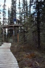
On river right, is George's Riffle, at the entrance to First Canyon, where we met a group of 10 with Nahanni River Adventures. They began at Rabbitkettle, for a cost of $2500 each. The leaders take responsibility, and no experience is necessary. They did, however, spend about 30 minutes steeling their nerves for this relatively straight forward rapid. We expected them to hit the eddy, where we are, on the left of the image, but they missed. Perhaps they didn't even try.


nahanni109.jpgThey ended up on this gravel bar way down river. I always like people to hit eddies. When I led trips, the first thing I wanted to know is can you hit an eddy. Can you get off the river?

When we were in Five-mile Canyon, Kathleen and I intended to take the main channel to the right of an island. We under estimated the power of the river, and were instead swept left around the island. I think it's always a mistake to let the river dictate where you go. Driftwood goes where the river takes it. I like to ask the rhetorical question, "Are we driftwood, or are we canoeists?"

https://www.youtube.com/watch?v=upsZZ2s3xv8


nahanni110.jpg
Floating through the last, or First Canyon, which is mostly limestone, and rises as much as 1,000 vertical metres (3,200 feet) above river level. Because of the limestone, many caverns of an extensive karst formation exist. The Grotte Valerie cave, where over 100 skeletons of wild sheep have been preserved in the "Gallery of the Dead Sheep." Presumably the sheep entered the cave to seek shelter from a storm, and could not re-emerge up icy slopes. These major caves are now closed to the public for safety reasons.


nahanni111.jpg
Kathleen preparing dinner at Kraus Hot Springs, where a tremendous wind arose, felling 2 cottonwood trees, and requiring us to hold on to the pots to keep them from blowing away. A Nahanni River Adventurer tent blew away.


nahanni112.jpg
From left to right, Carey, me and a Nahanni River Adventurer in Kraus Hot Springs. These Hot Springs provided an intermittent homesite for Gus and Mary Kraus between 1940 and 1971. The site had many chokecherries, and a black bear circled impatiently, while we soaked in the warm water, much appreciated on this 20th night of the journey. You might remember that canoeists coming of the Liard Fiver at Blackstone Landing three weeks ago reported that Kraus Hot Springs was under water.


nahanni113.jpg
Preparing for departure, just below the entrance to First Canyon, at Kraus Hot Springs.


nahanni114.jpg
The River changed character again, and was braided, fast, and shallow here in "The Splits," where we saw trumpeter swans.

We stopped for lunch, and as usual took only a short break before Carey and Janice headed for the canoe, and launch. Kathleen and I launched a couple of minutes later. As we rounded the bend, I looked back, and saw that John and Grace were still stretched out on the beach.

I called out, "Carey. Wait. John and Grace aren't on the water yet."

"They know we're going. If they don't want to come, that's their choice."

"Well, I'm going back."

Kathleen and I paddled back up river. "John. What are you doing. We're going."

"I'm not ready yet."

"OK. Suit yourself."


nahanni115.jpg
About an hour later, John and Grace passed our canoe. Grace was humming some unknown tune to herself. John didn't say anything.

As we approached the small Dene Community of Nahanni Butte, at the confluence with the Liard River, rain began to fall. We had intended to camp just down stream of Nahanni Butte, but continued on.


nahanni116.jpg
The rain stopped after about an hour, and the sun reappeared. Kathleen and I rafted up with Carey and Janice. John and Grace were a hundred yards or so ahead.

Carey said, "We're close to Blackstone Landing. No need to stop for dinner or to make camp. Here's some Landyaeger sausage. Plenty of quick calories."

We ate the sausages, and John and Grace were now about 200 yards ahead. It was their turn to make supper, and to select the campsite. A few minutes later they pulled out on a very nice beach on river right. We were paddling on river left, and just kept going. John Grace looked perplexed, like "What the....?

I know it sounds bad, but we just kept going. They'll catch up. They're stronger paddlers than us.

Our choice was to stay with Janice and Carey, or to join John and Grace. The choice was easy. Thinking about it now, it seemed we had just held our second unscheduled vote on the trip to stay or go. We had at least four votes to go.

The Liard River was now very sluggish, and we didn't reach Blackstone Landing until just before midnight, a total of 102 km (63 miles) covered today. Kathleen and I climbed into the van, opened a bottle wine, and dined on a bag of potato chips.

John and Grace arrived about an hour later.

A couple of months later I was at a meeting of canoeists. I talked about being on the Nahanni River that summer.

"Oh, you're the people who left John and Grace behind."

"They could have caught us if they wanted to. They had many times during the trip.


nahanni117.jpg
So, at least three things learned on this trip.

1) We did love canoe tripping;

2) Three boats do not always make a stronger trip. Choose carefully; and

3) Coffee table books are not as good as the real thing. Before our trip, I leafed through the "Nahanni Portfolio," by the Keoughs many, many times. Spectacular images. I looked forward to viewing them when I returned home. Got about half way through, and closed the book. Have not looked at it again until yesterday. Reality is much better.
 

Attachments

  • nahanni012.jpg
    nahanni012.jpg
    780 KB · Views: 0
Last edited:
My mind was made up. Kathleen and I are staying. I returned to the canoes where the discussion had ended.

Carey, Janice, Kathleen and I voted to stay. John voted to leave. Grace abstained. Andy didn't get a vote.

So that's good; but I didn't feel very happy about.

I was pulling for you. Sorry it was decided that everyone would stay.

It can kinda take the wind out of your sails when you come do a decision like that and then not get to invoke it.

Thanks for letting us follow along. This has been a great way to spend the winter so far.

Alan
 
Thanks again.
Another terrific story!
As others have already noted, your story telling ability combined with masterful pacing and exquisite photography is a real thrill to follow.

And I have definitely paddled with "John" or his brother. While it may not ruin a great canoe trip, paddling with a "problem" can leave a bad taste in your mouth. I'm pretty easy going- I'll paddle anywhere with anyone except...There are 2 paddlers I have determined to NEVER paddle with again. One, a great guy off the water, was an absolute arse on both trips I paddled with him. The other guy doesn't get a passing grade on dry land...

Bruce
 
You know you’re now my favorite author, right? You go interesting places, take wonderful pictures, and use beautiful words. Now, you have added “characters.” Everybody knows a “John.” Thank you for sharing this. Do you have any backpacking stories, too? ????

Pringles
 
Great report, and yes choose carefully who you go with or be ready to make concessions!! Not always easy to trip with other people, there has been over the years many an opportunity to go on nice trip with some people, but they weren't the right people for me so I said no!
This summer looks like we are planning a trip on the Wind River in the Peel watershed, my first trip in that watershed, second for my wife and the other couple that are coming. My wife's sister, her husband and our niece, me my wife and our daughter, 3 canoes!!
 
Thanks, Guys! Glad you like it. It was nice for me to revisit the story. Sorry, Pringles. I don't have any backpacking stories. Those days were a long time ago. Long before I was taking many pictures, which would have been all slides that would need to be scanned. Scanning is not all that easy. And the longest backpacking trip was only 8 days. Not a very riveting story.
 
You're going to have to take some new trips soon to keep your loyal fan base happy. Ya know, you could always drive to Northern Ontario and try a trip with a guy who might provide you with some interesting writing. I'm pretty much on top of my drinking problem, well at east I don't see it as a problem, and i could cook fish for you every night.
 
I have never paddled in Ontario before. Does this Blackfly song represent reality for Northern Ontario?

https://www.youtube.com/watch?v=qjLBXb1kgMo

I've only been to northern Ontario a few times but I'll say that no, it doesn't represent reality. I've never seen a snake play the accordion there.

That's a great song and animation. I introduced it to a 5 year old boy I mentor (now 7) and it quickly became his favorite.

Alan
 
Earlier in this TR, I said I that it's always a mistake to let the river dictate where you go. Driftwood goes where the river takes it. I like to ask the rhetorical question, "Are we driftwood, or are we canoeists?"

I then inserted the following link that shows highly skilled people, log drivers by profession, more or less riding/controlling driftwood. I just inserted, without actually encouraging people to view it. The video soon turns into another entertaining animated song. If you liked blackfly, you will probably like this one.

https://www.youtube.com/watch?v=upsZZ2s3xv8
 
Back
Top