- Joined
- Aug 21, 2018
- Messages
- 1,778
- Reaction score
- 2,107
I was not going to post this TR until April; but like Mike McCrea, I am not on Facebook. The only place I get any likes is on this CT site. So I'm going to post this TR now.
This posting is based on a slide show that Kathleen and I have prepared. When we did this trip, we had only one camera, and didn't take many pictures. Also, we did not keep journals, so do not have nearly as much information as later trip reports. Our presentation begins with how Kathleen and I gave up backpacking to become canoeists.
For those of you who might not know, The South Nahanni River enjoys a worldwide reputation as the premier wilderness water adventure. Virginia Falls (twice the height of Niagra), canyon walls rising 1000 m above river level, geological formations that escaped recent glaciation, and abundant wildlife enhance the region's sinister reputation for danger, as evidenced in place names such as Deadmen's Valley, Headless Creek, Funeral Range, and Broken Skull River. As we tell our audience, come paddle with us, to share the personal experience of 3 weeks and 567 km (350 miles) on this exciting river, and discover why Nahanni National Park was the first natural area declared by UNESCO as a World Heritage Site.

In 1986, Vancouver hosted the world's fair. Kathleen and I decided we would get out of town to avoid the crowds. We planned to go backpacking, with one other couple, in Mt. Edziza Provincial Park, in northern British Columbia. At the last minute, the other couple cancelled, and we changed our plans completely, We decided to drive up to the Yukon Territory, and visit the history in Dawson City. Here we are standing on the Midnight Dome, above Dawson City, looking down at the confluence of the Klondike River and the Yukon River. We knew immediately that we wanted to spend more time in that landscape.

When we returned home to Vancouver, we visited the Yukon Pavilion at Expo '86, and bought the book "Along the Dempster: An Outdoor Guide to Canada's Northernmost Highway," by Walter Lanz. We decided that in 1987 we would hike to the headwaters of the North Klondike River, 60 km (35 miles) northeast of Dawson City, where we were struck, here at 1:30 am, with the tremendous freedom to move provided by the Midnight Sun. (Notice the Ensolite pad for sleeping comfort. Although we purchased Therm-a-Rest pads a long time ago, we still have the old Ensolite pads. Never throw anything away. You never know when you might need it.)

Camped at the headwaters, at the base of Mt. Monolith, we knew that we wanted to spend all of our free time in Canada's north.

However, dense brush, without trails, made overland travel very difficult, and imposing for those of us, who in our mid- and late-thirties, already seem to be beyond our physical prime. Walter's book suggested that the one way hike of 16 km (10 miles) should allow 8 hours. Kathleen and I, with time out for dinner, took 15 hours, from 10:30 in the morning to 1:30 the next morning. When we finally got back to the campground where we had parked our vehicle, we chatted to the park attendant, and mentioned how much longer the hike took us than Walter suggested. She said, "Oh that's Walter. He wants you to know that he can do it, and you can't."
Indeed, the "fine print" in Walter's book said, "The distances in this guide are horizontal ones as measured on maps of the 1:50,000 scale. Actual distances will be considerably longer. Outdoor enthusiasts used to hiking on trails may find it odd to see time estimates which indicated progress no better than one kilometre per hour. Without trails, areas of dense vegetation and steep mountain slopes greatly hinder walking speed. Willow and alder which grow above head height are the worst vegetation to pass through, but even low brush and the open tundra take far longer than one would expect."
I didn't really read that until a long time after we had completed the hike. I never "read the full instructions first," either.

Driving home, we stopped at the look-out with a view into the Tintina Trench, southeast of Dawson City. Our eyes were drawn to the wide river valley heading off seemingly endlessly. We realized that rivers are the travel corridors of the North. We don't need to carry every thing on our backs, struggling through dense brush. We should become canoeists.
So we returned home, and went to the Western Canoeing (and Kayaking) in Abbotsford, British Columbia. Marlin Bayes, the owner of Western Canoeing, asked us what kind of canoeing we intended to do. “Are you interested in paddling whitewater?”
Nearly in unison, Kathleen and I replied, “No way. Not a chance. We don’t think we’d ever want to run rapids. Way too dangerous. We’re interested in canoeing serenely on calm lakes, or easy rivers. I heard the Yukon doesn't have many rapids. Maybe we'll paddle that some day. Mostly, though, we just want to paddle with the loons."
“OK, then, the best boat for you is my Clipper Tripper. It’s fast, stable and tracks very well. It’s ideal for what you want to do.”

For Christmas, we also bought Bill Mason's book "Path of the Paddle," which we studied almost every day.

We also joined the Beaver Canoe Club, and signed up for their Basic Paddler’s canoe course in the spring of 1988. We eventually learned how to perform a passable J-stroke, which earned us the right to join the club for a day trip on the South Nooksack River in Washington State.
In addition to the J-stroke, we also knew, and could marginally use, forward strokes, pry strokes, draw strokes and sweep strokes. All well and good. But we had no understanding of, or even exposure to, the concept of ferrying, which as you likely know, is extremely useful, even necessary, for leaving an eddy, or crossing a river.
Let me illustrate. Kathleen and I were somehow making it down the South Nooksack River without capsizing, and were even enjoying ourselves. Lots of adrenalin for us, even on this easy Class I river. At one point, though, we found ourselves in an eddy, from which we couldn’t escape. I don’t even remember how we got into that eddy in the first place. Maybe it just reached out and grabbed us. Anyway, as we had been told, we were facing upstream, but every time we nosed out into the current, our canoe spun around right back into the eddy. After three attempts we remained trapped, seemingly forever.
Les and Pauline, two founding veterans of the Beaver Canoe Club, had taken us under their wing (or should I say under their paddle?), and had been occasionally shepherding Kathleen and me down the river. I’m sure they were highly entertained by our inability to get out of that eddy. Eventually, though, perhaps becoming impatient, and tiring of the hilarity of our situation, Les said, “You need to ferry out a little bit more into the current, and then turn down.”
Oh. Real useful advice, particularly if we had any idea what a ferry was. “Well,” Les explained, “the paddler on the downstream side makes sure that they are leaning away from the current, so that it goes under the boat when you leave the eddy. If you don’t lean away, the current will grab the hull, and you will capsize to the upstream side. Then you both paddle hard enough to drive the canoe into the current, at just the right angle, and the current will sort of just carry you across to where you want to be. Just like otters do when they cross a river. Or like salmon do when they are migrating upstream. Try it.”
We tried it, and dang if it didn’t work. Now we were really becoming canoeists.
After leaving the eddy victoriously, Kathleen and I paddled down the South Nooksack River, under the watchful eyes of Les and Pauline, until we reached the North Nooksack River. Our vehicles were parked on the other side of the North Nooksack River, which thundered past us in what was the most colossally threatening rapid I had ever imagined. The North Nooksack River made a sharp bend to the right 100 or so metres (100 yards) down river, and disappeared from the face of the earth. This was why Kathleen and I told Marlin Bayes that we didn’t want to paddle rivers. No way. Not a chance.
Kathleen and I sat in the eddy at the confluence of the two rivers, with four other tandem boats, one of which contained first-time river paddlers, just like Kathleen and me. We watched the first of the more experienced paddlers ferry straight across the North Nooksack River, easy as you please. That was them, though. We were us. I sort of called out to Les and Pauline, “I don’t think we can do this.” No response.
The second experienced boat then ferried straight across the North Nooksack River. No problem at all. Again I said, a little louder this time, “I don’t think we can do this.” Why did we ever accept the club’s invitation to canoe down the South Nooksack River? They said it would be easy, but they were wrong. All Kathleen and I had wanted was to paddle serenely, with the loons, on calm lakes. And now, it seemed, we were going to die.
Les and Pauline then prepared to head across. “Yes, Kathleen and Michael, you can do this. Remember, a good ferry is all about momentum, lean and angle. Have momentum when you enter the current. Lean away from the current, and leave the eddy at the proper angle to let the current carry you across. Watch us.”
And then our mentors, Les and Pauline were gone, and soon stood on the opposite shore. That left just the other first-time river paddlers, plus Kathleen and me in the eddy, all four of us contemplating the certain abyss that waited for us around the sharp bend to the right. What were Kathleen and I going to do? As I mentioned twice already, I didn’t think we could do this. In fact, I was certain that we couldn’t ferry successfully across the North Nooksack River. Criminy, we had only heard about a ferry for the first time a scant 30 minutes ago. We didn’t really know what we were doing.
And then the other first-time river paddlers sprang into action. From what I know now, they likely didn’t lean down stream. They had barely entered the current, when it grabbed their hull, capsizing them upstream into the thunderous rapid. Doom would certainly quickly follow. But no. Before bending to the right, the North Nooksack River offered a small back eddy, into which the first-time river paddlers, their boat and all their gear were swept. Experienced canoe club members leaped into their boats, ferried back across the North Nooksack River, and quickly made all the necessary rescues.
“That wasn’t so terrible, Kathleen. Not as bad as I thought it would be. They didn’t die or anything. I think we should go.”
“Well, we really don’t have much choice, do we? Our car is on the other side.”
So, Kathleen and I pointed our boat upstream toward the current of the North Nooksack River, at the same angle as demonstrated by Les and Pauline. I leaned downstream, and we both paddled, somewhat tentatively, into the most horrendous current I had ever imagined. Almost miraculously we didn’t capsize, and we didn’t lose our angle. We paddled as hard as we could, and ferried directly across the North Nooksack River toward the welcoming arms of Pauline Mushens. We literally leaped out of our Clipper Tripper to stand on shore, feeling extraordinarily triumphant and exhilarated.
I should acknowledge that my description of that terrifying rapid on the North Nooksack River was likely much exaggerated. It was probably no more than a low Class II, but it scared the bejeebers out of Kathleen and me. It must have also scared the bejeebers out of our fellow first-time river paddlers, as I never saw them again. I never even knew their names.
Now, finally, comes the reason why I’m telling you about our first river adventure on the South Nooksack River. That one day on the South Nooksack River ended our unfounded anxiety about paddling whitewater. We now actually looked forward to developing our skills at canoeing down rapids. The next weekend, Kathleen and I bought a canoe a little more appropriate for wilderness rivers—a Royalex Mad River Explorer.

With the Beaver Canoe club, we had companions, guides, and instructors for year-round canoeing throughout southern British Columbia. The Chilliwack River is about a one-hour drive east of Vancouver.

In the summer of 1988, Kathleen received a pay cheque that included retroactive pay. I said, "It's your money. Do whatever you want with it."
She said, "I want a white water play boat, like Peter has. A Mohawk XL 13."
At the time this canoe was considered a short boat. And we still have it, although it mostly sits in the barn, as there is no white water around Preeceville. We are open to offers.
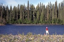
Here is Kathleen on the Seymour River, that was only about 20 minutes from our home in North Vancouver. We could do our own shuttle. Kathleen paddled her Mohawk. I soloed the Explorer.

We went out a couple of times a week to practice. Kathleen ferries back-and-forth in the "Toilet Bowl" at the top of the run.

We were always looking for new water, and new experiences. Kathleen prepares to paddle Dry Creek in the Yukon Territory.

Nice cross-bow draw, Kathleen! In those days, the ubiquitous Mohawk was our spare paddle. Not anymore, but we still have them. Never throw anything away. You never know when you might need it.
We were now skilled in many varieties of water levels and conditions: high water, low water, and no water. Finally we were ready for a wilderness canoe trip. But where to go?

In the spring of 1990, Carey and Janice invited us to join them on the South Nahanni River, in the southwest corner of the Northwest Territories.
This posting is based on a slide show that Kathleen and I have prepared. When we did this trip, we had only one camera, and didn't take many pictures. Also, we did not keep journals, so do not have nearly as much information as later trip reports. Our presentation begins with how Kathleen and I gave up backpacking to become canoeists.
For those of you who might not know, The South Nahanni River enjoys a worldwide reputation as the premier wilderness water adventure. Virginia Falls (twice the height of Niagra), canyon walls rising 1000 m above river level, geological formations that escaped recent glaciation, and abundant wildlife enhance the region's sinister reputation for danger, as evidenced in place names such as Deadmen's Valley, Headless Creek, Funeral Range, and Broken Skull River. As we tell our audience, come paddle with us, to share the personal experience of 3 weeks and 567 km (350 miles) on this exciting river, and discover why Nahanni National Park was the first natural area declared by UNESCO as a World Heritage Site.
In 1986, Vancouver hosted the world's fair. Kathleen and I decided we would get out of town to avoid the crowds. We planned to go backpacking, with one other couple, in Mt. Edziza Provincial Park, in northern British Columbia. At the last minute, the other couple cancelled, and we changed our plans completely, We decided to drive up to the Yukon Territory, and visit the history in Dawson City. Here we are standing on the Midnight Dome, above Dawson City, looking down at the confluence of the Klondike River and the Yukon River. We knew immediately that we wanted to spend more time in that landscape.
When we returned home to Vancouver, we visited the Yukon Pavilion at Expo '86, and bought the book "Along the Dempster: An Outdoor Guide to Canada's Northernmost Highway," by Walter Lanz. We decided that in 1987 we would hike to the headwaters of the North Klondike River, 60 km (35 miles) northeast of Dawson City, where we were struck, here at 1:30 am, with the tremendous freedom to move provided by the Midnight Sun. (Notice the Ensolite pad for sleeping comfort. Although we purchased Therm-a-Rest pads a long time ago, we still have the old Ensolite pads. Never throw anything away. You never know when you might need it.)
Camped at the headwaters, at the base of Mt. Monolith, we knew that we wanted to spend all of our free time in Canada's north.
However, dense brush, without trails, made overland travel very difficult, and imposing for those of us, who in our mid- and late-thirties, already seem to be beyond our physical prime. Walter's book suggested that the one way hike of 16 km (10 miles) should allow 8 hours. Kathleen and I, with time out for dinner, took 15 hours, from 10:30 in the morning to 1:30 the next morning. When we finally got back to the campground where we had parked our vehicle, we chatted to the park attendant, and mentioned how much longer the hike took us than Walter suggested. She said, "Oh that's Walter. He wants you to know that he can do it, and you can't."
Indeed, the "fine print" in Walter's book said, "The distances in this guide are horizontal ones as measured on maps of the 1:50,000 scale. Actual distances will be considerably longer. Outdoor enthusiasts used to hiking on trails may find it odd to see time estimates which indicated progress no better than one kilometre per hour. Without trails, areas of dense vegetation and steep mountain slopes greatly hinder walking speed. Willow and alder which grow above head height are the worst vegetation to pass through, but even low brush and the open tundra take far longer than one would expect."
I didn't really read that until a long time after we had completed the hike. I never "read the full instructions first," either.
Driving home, we stopped at the look-out with a view into the Tintina Trench, southeast of Dawson City. Our eyes were drawn to the wide river valley heading off seemingly endlessly. We realized that rivers are the travel corridors of the North. We don't need to carry every thing on our backs, struggling through dense brush. We should become canoeists.
So we returned home, and went to the Western Canoeing (and Kayaking) in Abbotsford, British Columbia. Marlin Bayes, the owner of Western Canoeing, asked us what kind of canoeing we intended to do. “Are you interested in paddling whitewater?”
Nearly in unison, Kathleen and I replied, “No way. Not a chance. We don’t think we’d ever want to run rapids. Way too dangerous. We’re interested in canoeing serenely on calm lakes, or easy rivers. I heard the Yukon doesn't have many rapids. Maybe we'll paddle that some day. Mostly, though, we just want to paddle with the loons."
“OK, then, the best boat for you is my Clipper Tripper. It’s fast, stable and tracks very well. It’s ideal for what you want to do.”
For Christmas, we also bought Bill Mason's book "Path of the Paddle," which we studied almost every day.
We also joined the Beaver Canoe Club, and signed up for their Basic Paddler’s canoe course in the spring of 1988. We eventually learned how to perform a passable J-stroke, which earned us the right to join the club for a day trip on the South Nooksack River in Washington State.
In addition to the J-stroke, we also knew, and could marginally use, forward strokes, pry strokes, draw strokes and sweep strokes. All well and good. But we had no understanding of, or even exposure to, the concept of ferrying, which as you likely know, is extremely useful, even necessary, for leaving an eddy, or crossing a river.
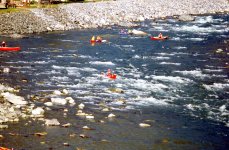
Let me illustrate. Kathleen and I were somehow making it down the South Nooksack River without capsizing, and were even enjoying ourselves. Lots of adrenalin for us, even on this easy Class I river. At one point, though, we found ourselves in an eddy, from which we couldn’t escape. I don’t even remember how we got into that eddy in the first place. Maybe it just reached out and grabbed us. Anyway, as we had been told, we were facing upstream, but every time we nosed out into the current, our canoe spun around right back into the eddy. After three attempts we remained trapped, seemingly forever.
Les and Pauline, two founding veterans of the Beaver Canoe Club, had taken us under their wing (or should I say under their paddle?), and had been occasionally shepherding Kathleen and me down the river. I’m sure they were highly entertained by our inability to get out of that eddy. Eventually, though, perhaps becoming impatient, and tiring of the hilarity of our situation, Les said, “You need to ferry out a little bit more into the current, and then turn down.”
Oh. Real useful advice, particularly if we had any idea what a ferry was. “Well,” Les explained, “the paddler on the downstream side makes sure that they are leaning away from the current, so that it goes under the boat when you leave the eddy. If you don’t lean away, the current will grab the hull, and you will capsize to the upstream side. Then you both paddle hard enough to drive the canoe into the current, at just the right angle, and the current will sort of just carry you across to where you want to be. Just like otters do when they cross a river. Or like salmon do when they are migrating upstream. Try it.”
We tried it, and dang if it didn’t work. Now we were really becoming canoeists.
After leaving the eddy victoriously, Kathleen and I paddled down the South Nooksack River, under the watchful eyes of Les and Pauline, until we reached the North Nooksack River. Our vehicles were parked on the other side of the North Nooksack River, which thundered past us in what was the most colossally threatening rapid I had ever imagined. The North Nooksack River made a sharp bend to the right 100 or so metres (100 yards) down river, and disappeared from the face of the earth. This was why Kathleen and I told Marlin Bayes that we didn’t want to paddle rivers. No way. Not a chance.
Kathleen and I sat in the eddy at the confluence of the two rivers, with four other tandem boats, one of which contained first-time river paddlers, just like Kathleen and me. We watched the first of the more experienced paddlers ferry straight across the North Nooksack River, easy as you please. That was them, though. We were us. I sort of called out to Les and Pauline, “I don’t think we can do this.” No response.
The second experienced boat then ferried straight across the North Nooksack River. No problem at all. Again I said, a little louder this time, “I don’t think we can do this.” Why did we ever accept the club’s invitation to canoe down the South Nooksack River? They said it would be easy, but they were wrong. All Kathleen and I had wanted was to paddle serenely, with the loons, on calm lakes. And now, it seemed, we were going to die.
Les and Pauline then prepared to head across. “Yes, Kathleen and Michael, you can do this. Remember, a good ferry is all about momentum, lean and angle. Have momentum when you enter the current. Lean away from the current, and leave the eddy at the proper angle to let the current carry you across. Watch us.”
And then our mentors, Les and Pauline were gone, and soon stood on the opposite shore. That left just the other first-time river paddlers, plus Kathleen and me in the eddy, all four of us contemplating the certain abyss that waited for us around the sharp bend to the right. What were Kathleen and I going to do? As I mentioned twice already, I didn’t think we could do this. In fact, I was certain that we couldn’t ferry successfully across the North Nooksack River. Criminy, we had only heard about a ferry for the first time a scant 30 minutes ago. We didn’t really know what we were doing.
And then the other first-time river paddlers sprang into action. From what I know now, they likely didn’t lean down stream. They had barely entered the current, when it grabbed their hull, capsizing them upstream into the thunderous rapid. Doom would certainly quickly follow. But no. Before bending to the right, the North Nooksack River offered a small back eddy, into which the first-time river paddlers, their boat and all their gear were swept. Experienced canoe club members leaped into their boats, ferried back across the North Nooksack River, and quickly made all the necessary rescues.
“That wasn’t so terrible, Kathleen. Not as bad as I thought it would be. They didn’t die or anything. I think we should go.”
“Well, we really don’t have much choice, do we? Our car is on the other side.”
So, Kathleen and I pointed our boat upstream toward the current of the North Nooksack River, at the same angle as demonstrated by Les and Pauline. I leaned downstream, and we both paddled, somewhat tentatively, into the most horrendous current I had ever imagined. Almost miraculously we didn’t capsize, and we didn’t lose our angle. We paddled as hard as we could, and ferried directly across the North Nooksack River toward the welcoming arms of Pauline Mushens. We literally leaped out of our Clipper Tripper to stand on shore, feeling extraordinarily triumphant and exhilarated.
I should acknowledge that my description of that terrifying rapid on the North Nooksack River was likely much exaggerated. It was probably no more than a low Class II, but it scared the bejeebers out of Kathleen and me. It must have also scared the bejeebers out of our fellow first-time river paddlers, as I never saw them again. I never even knew their names.
Now, finally, comes the reason why I’m telling you about our first river adventure on the South Nooksack River. That one day on the South Nooksack River ended our unfounded anxiety about paddling whitewater. We now actually looked forward to developing our skills at canoeing down rapids. The next weekend, Kathleen and I bought a canoe a little more appropriate for wilderness rivers—a Royalex Mad River Explorer.
With the Beaver Canoe club, we had companions, guides, and instructors for year-round canoeing throughout southern British Columbia. The Chilliwack River is about a one-hour drive east of Vancouver.
In the summer of 1988, Kathleen received a pay cheque that included retroactive pay. I said, "It's your money. Do whatever you want with it."
She said, "I want a white water play boat, like Peter has. A Mohawk XL 13."
At the time this canoe was considered a short boat. And we still have it, although it mostly sits in the barn, as there is no white water around Preeceville. We are open to offers.
Here is Kathleen on the Seymour River, that was only about 20 minutes from our home in North Vancouver. We could do our own shuttle. Kathleen paddled her Mohawk. I soloed the Explorer.
We went out a couple of times a week to practice. Kathleen ferries back-and-forth in the "Toilet Bowl" at the top of the run.
We were always looking for new water, and new experiences. Kathleen prepares to paddle Dry Creek in the Yukon Territory.
Nice cross-bow draw, Kathleen! In those days, the ubiquitous Mohawk was our spare paddle. Not anymore, but we still have them. Never throw anything away. You never know when you might need it.
We were now skilled in many varieties of water levels and conditions: high water, low water, and no water. Finally we were ready for a wilderness canoe trip. But where to go?
In the spring of 1990, Carey and Janice invited us to join them on the South Nahanni River, in the southwest corner of the Northwest Territories.
Attachments
Last edited: