Now we need Rippy to commit and bring Stabby for us to ogle for ten days.
-
Happy National Bikini Day! 🏖️👙👀
You are using an out of date browser. It may not display this or other websites correctly.
You should upgrade or use an alternative browser.
You should upgrade or use an alternative browser.
Marshall Lake 2015
- Thread starter memaquay
- Start date
- Joined
- Jun 30, 2014
- Messages
- 1,550
- Reaction score
- 589
I suppose I had better bring extra pancake mix now. I think we can forego the honourary Canadian ceremony, Robin has been on the roster for quite a while already. We can do the wobbly pop part though, just to make it official.
Nice to have you aboard.
Christy
Nice to have you aboard.
Christy
Lookin' forward to seeing my "friends of Memaquay's backyard" again, it's a great paddling destination and well worth the ride, even twice.
Irene is pretty excited already, planning the Friday night sacrifice to the Cow Gods!
Irene is pretty excited already, planning the Friday night sacrifice to the Cow Gods!
If it is anything like last year, I'm going to starve myself for two days prior.
We are presently floating the idea of bringing two solo's, my Chestnut Fox and either Christine's Stripper or even this little Tremblay if we still have it. We just are not sure it is feasible with my shoulder issues, but something to think about for 5 months.
If you need a bigger tandem, I could arrange for a wennonah spirit 11, 44 pounds, nice canoe, very light to carry.
No, the Mattawa suits our tripping just fine, Christine was just putting out an idea. If I brought the Fox, I could then sell it to Robin to take home with him! ")
My son just e-mailed me a map sheet he made covering our route. I'll download it onto a memory stick and find a print shop that'll make me nice sheet or two, or three, or four... I'll keep you posted. If this works out, I'll keep sending him canoe routes I'd like to make full map sheets for.
Sounds pretty interesting!
All he did was "centre" our route using the 4 topo map sheets, so we'd wind up with a single new adjusted sheet. He'll crop it more if I want, but I like it large. I've got some other plans for this also. A key etc, and maybe something customized. We'll see.
My information for that route is not pinpoint accurate like some of my others. When I go through in June, I'll have a cohesive route, with tracking data and stuff. Can your SIL incorporate garmin files?
I'll let you know as soon as I get a reply. Yeah, it would be nice to have campsites and portages included on this Marshall topo. Coordinates noted beside campsites too?
That might be helpful for some, but it might start to clutter up the map pretty quickly. Coordinates could always be on a separate page, plus if its a 1:50 topo you can simply read the coordinate off the map fairly quickly. If you prefer to hand write on your map, you could bring just the topo and we could update it every night with very accurate stuff, or I could send you the updated info in June and you could pen it in then.
I only have one major area of confusion on my maps, although on the river, it is perfectly clear. My GPS marked the start of the port before the falls about 400 meters from where it seems like it should be on the map. I'm looking forward to clearing that stuff up.
I only have one major area of confusion on my maps, although on the river, it is perfectly clear. My GPS marked the start of the port before the falls about 400 meters from where it seems like it should be on the map. I'm looking forward to clearing that stuff up.
- Joined
- Jun 30, 2014
- Messages
- 1,550
- Reaction score
- 589
I am decidedly on the opposite end of the spectrum when it comes to navigation. I only need a map/ compass/ and some landmarks to check off. As long as there is an X on the map where the campsite is, I can find it.
Karin likes to GPS waypoint everything with exact distances and such. I work on the old school method...I figure distance by how long it takes to travel it. I dont care how far it is, just how long it takes me to get there. And of course I can guestimate that by a quick look at the map. I need to practice more though as I have been lazy with just either following the river or letting her do the Nav.
I figure I can just sit back and follow the bread crumbs on this one....lol ( or beer cans).
I do waypoint campsites and portages, but mostly the GPS goes along as a clock. I never even go through one set of batteries per season.
After I get home from a trip I can download the waypoints onto my maps on the computer and everything is there for the next time, or if I'm doing a detailed trip report to post on MyCCR for others to use.
After I get home from a trip I can download the waypoints onto my maps on the computer and everything is there for the next time, or if I'm doing a detailed trip report to post on MyCCR for others to use.
Well thank goodness I'm not the only one who thinks putting a compass on a string is going high tech. Iskweo paddles my speed, so to speak. We were supposed to invest in a GPS this year, but I'm not sure if we'll get around to it. It's looking like a busy spring and summer already. (Cue the excuses from Brad.) The Gear Acquisition Syndrome has me looking hard at sleeping pads and bags, and even tents! (Did I go too far into the tiny & lightweight direction?) But I'm still happy with simple map and compass, and not so inclined to spend money and interest in that department.
I'm not happy yet with the map my son has sent me. It needs more work. If he wasn't so darned busy with his own life, he could spend more time helping me improve mine. How can a kid be so selfish!? (Ha!)
I sent him the link to mem's Marshall maps to see if he can incorporate those into a full sheet topo.
Last edited:
I need a new sleeping pad as well and am considering the Synmat 9 but they are order only and could take 6 months. The alternative would be the NeoAir Dream. About the same money, $225. The downside of the NeoAir is the air part, but the dream has a padded cover and is 4 inches thick but still packs smaller than regular foam type systems.
We don't need new sleeping pads, but would like a better night's sleep. I'm trying to pinch pennies and pounds. I'm leaning to the NeoAir All Season (2 of them). I'm also looking at a bigger Hubba. Mutha? Poppa? The 2 person is nice, light and with gear shed provides ample front porch room for stuff. But it's not exactly rooomy. Let me put it this way. We sleep fine in it, if we take turns breathing.
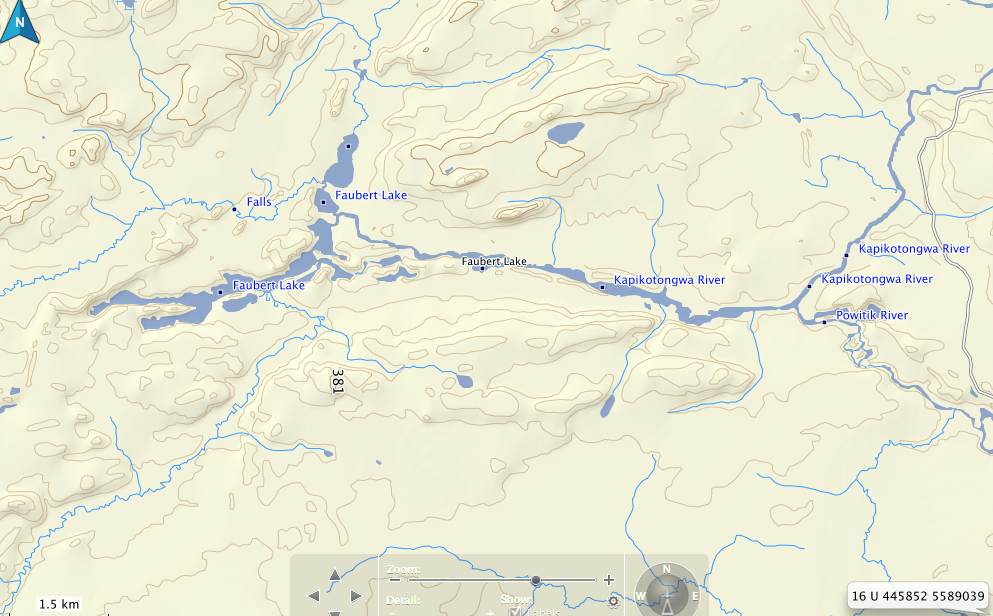
I was talking to my buddy that goes on the school trips with me. We were looking at the maps, trying to figure out a schedule for the school kids. Where the Powitick joins the Kap, we've always wondered what was upstream on the Kap. Faubert Lake looks very interesting, looks pretty remote and unexplored. Anyway, we are going to check it out with the kids, and if it is interesting, it might be something to throw into our trip too.

Similar threads
- Replies
- 13
- Views
- 2K
- Replies
- 8
- Views
- 604
- Replies
- 6
- Views
- 821