• Happy Star Wars Day! 🌇🚶🏼‍,👑👊🏼🔙

Map Storage/Organization

Joined
Mar 23, 2015
Messages
114
Reaction score
1
My Dad recently gave me about 50+ topographic maps, many with canoe routes on them. Right now most are rolled, with some being folded. What way do you store your maps? Do you have anyway you organize your maps? I'm looking for ideas now that it's winter. Also, does anyone have a map coating manufacturer you would recommend? I'd like to coat them since most are just plain paper. Any help input/suggestions/help appreciated!
 
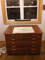
In the mapping business we would use large flat file cabinets with drawers to store map sheets. Not a typical piece of furniture in the average home. Hard cardboard tubing with end caps provide good storage protection. There are firms in the printing industry that will laminate large map sheets. My local Office Depot will laminate sheets - I think up to 11X17 sheets.

If your sheets are valuable - like the ones with routes on them, consider getting them copied by a engineering size copier and you'll always have one for field use and the other in archive for future copies.

A firm that can copy engineering size documents are likely to have laminating equipment that might handle larger formats.
 
I have a can of 'stuff' called Storm Proof a water type liquid that is applied to the paper to waterproof it. It works like a charm and I have treated many maps with it. Unfortunately the can now is rusty and the label all but unreadable the last time I looked. I'll have to dig it out and and see if I can decern any usable info.
Jim
 
I have somewhere in excess of 200 USGS paper topo maps, mostly of NY state, that I use for personal recreation, teaching land nav, and for SAR. I keep the most immediately useful maps in a wooden chest of drawers that my wife obtained and built for me. the others are kept unfolded and flat on a table in the basement. All are alphabetized and color referenced on the state topo index map. Years ago I discovered that Thompson's water seal is an excellent preservative for the maps. not only does it make them completely waterproof, but it makes them quite tough and tear resistant. For the Yukon River races, I print my route from Google Earth on regular bond computer paper ( 1000 miles on 95 sheets). They can easily be made waterproof by using a cheap waterproof spray from Walmart, or Thompson's.
H508OVm.jpg
 
I'm going to look into all of this... Thank you for the replys.
 
My Dad recently gave me about 50+ topographic maps, many with canoe routes on them. Right now most are rolled, with some being folded. What way do you store your maps? Do you have anyway you organize your maps?

I probably have 100 or more topo maps from trips to and through various States across the country. I think I have dang near the entire State of Maryland outside the urban areas.

I guess topo map storage depends on how you use (or don’t use) the maps.

I bring and use topographic maps on trips, so mine are all folded for in-boat convenience. Twice folded, once lengthwise and once width wise, so they are mostly 13 ½ inches by 11 ¼” inches. That size fits nicely inside a large Gaia map case with a window on both sides, so I can fold the maps and load the case in the order most beneficial for subsequent miles.

Some of them are pretty oft used fold tattered, but I can’t imagine using a flat or rolled topo map during a paddling trip. There is probably a way, but it would seem awkward and inefficient at best. I have a sail and don’t need to be holding up a giant sheet of paper while underway.

Not actually true. I have a topo map of the entirety of Assateague Island that is scrolled. Two scrolls, one north end and one south. The island spans two States and inconveniently hits just a corner of several topos, so it was easiest to cut & paste the relevant map sections together into two scrolls, each about 3 feet long by 12 inches wide.

Since the other topos are all folded to that map case size they are stored in a 5-drawer file cabinet with hanging file folders for all 50 States. Some State areas get their own hanging file for ease of information retrieval; the Adirondacks alone takes up two files.

That file cabinet is an artifact of dozens or crosscountry trips in the pre-internet era, with thousands of State and Nat’l handouts, brochures, park maps and etc. I still pull info and publications from those files when planning a trip, and any trip or park info I have printed from the net goes into those files as well, so I don’t have to find and print it again.

Those files are also open to friends planning trips, and it is a joy to sit down with them and pull out the appropriate State file to see what jogs the memory. “Oh, now that’s a cool place”. All I ask is please return what they borrowed, and bring me copies of freebie handouts and maps for the files if they found a special spot along the way.

One helpful hint if you store folded topos; it pays to fold (or refold) them so that the bottom right corner is visible, otherwise it is just a mystery map. Grabbed at random from the Maine – New York file drawer (lotta M and N or “New” States). I didn’t need to unfold it; Trout Brook Mtn, Maine, Provisional Edition 1988, 46068-B7-TF-024. Ah, Grand Lake Matagamon; just looking at those topos is a rush or memories, I dang near sunk a loaded canoe in that lake.
 
My local Office Depot will laminate sheets - I think up to 11X17 sheets.

The only laminated maps I have are 8 ½ x 11 mapping software print outs, many of them courtesy of friends JSaults and Willie Derness (thanks).

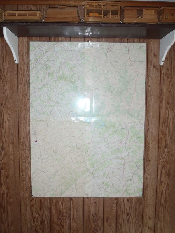
Also not actually true. I have made several laminated wall-hung four-topo map displays. That required trimming and taping the interior margins to fit together precisely, eliminating all of the blank space outer margins and cut & pasting the scale, declination, contour and road/trail legends atop some uninteresting corner of map area.

We have one of those 1:24,000 scale 4-topo map displays on the family room wall, showing the area surrounding our home for miles in every direction, and I have made them as gifts from friends. I found a laminating company that could do 34 inches wide (by any length), so those quad quadrangle display maps are two wide and two tall (33 inches by 45 inches), with a half inch of laminated lap on each side. That covers a lot of home stomping grounds.

(BTW, the guys at the laminating company were kinda into it, especially as I came back repeatedly to have new display maps made for far flung areas)

The three laminated quad quads I made for friend’s are all prominently displayed in their homes or cabins/camps, and I hope are used as often as I refer to the one for my native surrounds. I know that rural area like the back of my hand, or think I do; I still find and look into new land, lake or stream features using that wall map.

I suck at making picture frames, so those display maps simply have tiny grommets along the edges, with small brass screws and finish washers holding them to the wall. Your finish carpentry skills may vary.

Laminated wall display quad quads could be a Christmas gift idea for the hard to buy for, especially if they are mapheads living in an interesting area. The lamination wasn’t cheap, like $30 at the time, plus the cost of the topos, but it is a gift that keeps on giving.
 
I have made several laminated wall-hung four-topo map displays. That required trimming and taping the interior margins to fit together precisely, eliminating all of the blank space outer margins and cut & pasting the scale, declination, contour and road/trail legends atop some uninteresting corner of map area...... The lamination wasn’t cheap, like $30 at the time, plus the cost of the topos, but it is a gift that keeps on giving.

Neat idea. It might take away some of the personal touches that would go into doing it by hand you can go to mytopo.com and get custom maps of any area you want in multiple scales and sizes. Another nice touch is the ability to choose horizontal or vertical to make the best use of page space. You can get either folded or rolled. I just checked and a waterproof 36x48 map is $30. A laminated version of the same map would be around $60.

You can have your name printed on the map, give the map a name and short description, and choose if you want full grid lines, cross hatches, or nothing for Lat./long. and UTM grids. Each maps gets its own ID number so if you give them that ID number they can print off another identical copy.

36x48 is a bit big for tripping but would be a nice size for hanging on the wall. The 24x36" size is nice for tripping and if you have the money (and wall space) you can order up to 5x8'.

We're getting off topic but I'm surprised more people don't use services like mytopo. It's easy to use and the ability to customize the area you want mapped is great. No need to buy an entire map just because you need one little corner of it. I'm heading to SE Arizona in February and have been making myself lots of maps for hiking. The entire Chiricahua range (7 maps), Gila Box area (2 maps), most of the Santa Rita range (1 map) part of the Rincon Wilderness, and maybe up around Bear Wallow and Escudilla Mountain as well. On the printed map it shows what USGS maps the image is taken from. Some of the single 24x36 (1:24,000) maps I get are taken from pieces of 6 USGS 1:24,000 maps. I'd much rather carry one map than six.

This link should take you to the information for one of the Chiricahua maps. There will be a preview link there where you can see the whole map. http://www.mytopo.com/review.cfm?mytopoid=1535604E462

Alan
 
Last edited:
At work once, I had a map drawer cabinet... that's ideal. Would love to find a wooden one like BWCA66 posted.

At home, I have a large bulletin board in my gear room/man cave/study/craft room/refuge. I hang the current area of interest there. It's usually someplace in the Adirondacks or my local National Forest.

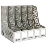
I also have a bunch of folded maps. These just go on a shelf in one of those slotted desk organizers, just so they don't all get crushed together or lost in the back. Kind of looks like this:
2.jpg
 
Having been an engineer for forty years, I would prefer to keep flat maps in flat files. Rolled maps are a distant second since it is very difficult to get them flat again. I would not fold a map unless I planned to take it into the field. The creases damage the paper more than I like. I would normally make a copy of a map that I was going to take into the field and leave my originals in the office. If I had a bunch of new maps that I wanted to preserve, I would take them to a blueprint place with a big scanner and get them scanned to pdf files. I haven't done this for several years, so I'm not sure what the cost would be. Once they have been scanned, they can always be reprinted. If they are scanned before they get creased, the quality would be better. If they are just USGS topo maps with no additional information, I would not scan them. .pdf files of most topo maps are available online or can be reproduced through an outfit like Caltopo.
 
We have a CD that contains all of the topos for Manitoba and some of WCPP. We just print 8.5x11 sheets of what we want in any magnification that suits us. Then laminate and we are good to go. Or just print em and toss em when we are done. I have all kinds laying around.

Christy
 
You guys all had great input and ideas. I'm currently in the process of making them all lay flat again, and then going from there. I found a map drawer cabinet, but it was $600, might try making one too. We'll see. Thanks again everyone!
 
you might try searching craigslist for a "blueprint cabinet". Back in the 70's when I worked on the railroad we had a 4 foot long four legged table that the top was hinged on and underneath was a compartment to hold all the signal system circuit schematics. It worked very well and get everything flat.
 
Neat idea. It might take away some of the personal touches that would go into doing it by hand you can go to mytopo.com and get custom maps of any area you want in multiple scales and sizes.

Such a service was undrempt of when I was making those giant local-area topo maps. That would have made creating such wall decoration reference much easier, and some of those topos were already old in revision date when I put them together.

Being able to personalized the giant map, center a friend’s home or camp just so, or off-centered to encompass the most interesting surrounds, would be a boon.

This link should take you to the information for one of the Chiricahua maps.

There is a laminated 4-quad topo on the wall of the Chiricahua cabin, now 30 years out of date but still fun to look at.

I still prefer the look of old-school 1:24000’s; I can drop myself into that map and visualize my surroundings like donning virtual reality glasses

Orthophotomap topos not so much, they are too colorfully distracting to get a good feel for contour lines.
 
They would look better if I had framed them.


The back of my hand local stuff is still fascinating.
 
Back
Top