• Happy "Killer Rabbit" Attacks President Carter in His Paddle Boat (1979)! 🚣🏼‍♂️🐇

Useless countdown activities

Joined
Mar 16, 2017
Messages
221
Reaction score
124
When a canoe trip is approaching, particularly when a body has been cooped up so very long, there are a few activities to help you waste time before the departure day. My favorites are watching the USGS river levels starting about 3 months in advance, seeing the water levels go from too high to just right, then continue on to so far below optimum that you start to consider bailing. Then after a rain storm, your hopes are buoyed up along with the river levels. This continues until 15 days before the trip, when you can also observe the 15 day forecast and artfully predict levels by the percent chance of rain, cloud cover, etc. Then, every day, you can see one more day of the trip. Day 1 rain. Day 2 rain. Day 3 rain and headwind and so on. But the next day the forecast changes and it's all sunny with light wind. And then back again. Of course, once you get out there, it snows but not enough to keep the blackflies away!
 
Yeah but how many times do you pack and unpacked your pack?

Being a consummate procrastinator I don't have many of these problems. I don't have any trouble filling my time before the trip because I'm scrambling to finish all the things I need to get done before the trip that I've been putting off until the last minute.

And the packs gets packed only one time. In the few days leading up to the trip gear starts finding it's way into the living room where it's piled up and then, just before departure, usually after work on Friday, things start getting put away into packs and then transferred into the car. By then (past midnight) I'm too wired for sleep so just hop in the car and start driving and wondering if I remembered everything.

Alan
 
Yeah but how many times do you pack and unpacked your pack?

Pack and unpack? After a fashion; I am typically packed a week before departure for long distance or long awaited trips, using an extensive every-possible-item for any-possible-trip or season checklist.

The problem becomes, packed with a week left to continue reviewing the everything-list, I tend to keep adding items I had already decided I didn’t need. And the night before I leave I skinny the load down a bit, “Don’t really need this, or that, or what was I thinking this” although the pile never as skinny as at first.

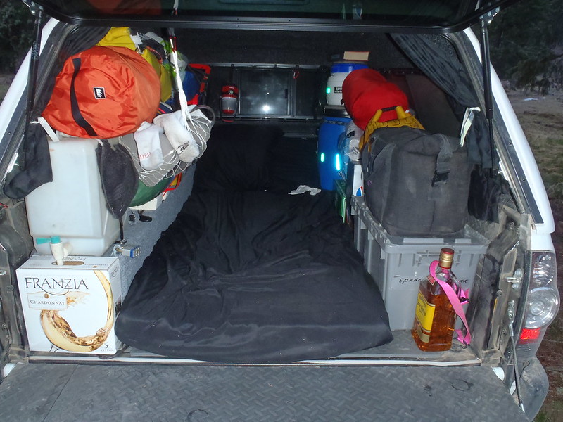
Travelling in the tripping truck with a companion it all has to fit.

P4151833 by Mike McCrea, on Flickr

At least the bar is open. NOTE: I don’t drink wine, or Tequila, but there is beer in the cooler.

My favorites are watching the USGS river levels starting about 3 months in advance, seeing the water levels go from too high to just right, then continue on to so far below optimum that you start to consider bailing.

Yup, all that. Maybe not totally useless.

I tend to start looking a month before a trip, trying to get a feel for how levels are changing with the season and looking at the historical averages. I do the same with the area’s weather forecast and historic norms.

We bailed on one multi-day trip before even leaving home. Quickly repacked, loaded different boats and drove 300 miles in the opposite direction. Wise decision.


Bailed on a couple day trips, or at times should have. I paid zero attention to the forecast on a local river daytrip; I knew it had been raining, and wasn’t supposed to let up. I didn’t even consider a day-long deluge overtopping an upstream dam. 2.8 feet is a usually nice level, we put on at around 3.5. And rising. Fast.

The river spiked to 12 feet and overwashed low bridges as we got near the end. Fastest 15 dumbass miles I’ve ever done.

Called off a couple trips when wiser heads prevailed. Arrived at a riverside meetup in the pouring rain to set the shuttle. Five guys stood sheltered under the bridge watching large trees hurling downriver, tumbling sideways with green limbs and branches cartwheeling above the surface (sawyering?).

Five guys stood under the bridge for a half hour hemming and hawing, no one wanting to be the first to suggest “This would be stupid”. Someone finally did, and there has never been such instant agreement and acclaim.

At least we didn’t spend the night perched in a tall tree, desperately clinging to the branches, keeping each other awake while our gear washed away.

I’ve heard tell of such tales.
 
I never know whether I should be amused or depressed at my atavistic irrelevancy.

In the days when I was taking serious trips, there was no such thing as USGS gauges to "watch". No internet. No cell phones. No electronics. If lucky, I knew a Tristan or Isolde who lived near the river and who would be kind enough to go take a look and phone you with a predicted guess for the next day's water level.

But for 40 years I've always had a van dedicated to canoe tripping. All my canoe gear, camping gear and clothing was always packed in it. So was my (dehydrated) food box and ice chest. All I needed to do in order to scoot away for the weekend, or at the very most two weeks, was to get some ice and Schweppes diet ginger ale for the cooler.

But I always went. If river A didn't have water, then I went to backups B or C, etc. Or the nearest interesting lake. To rely solely on one water body was foolish. I'm not talking about paid-in-advance, far-north extended Canadian wilderness trips. I've never done those. I did this alone, but even when tripping with one my several formal or informal canoe groups, we all followed the same flexible, extemporaneous approach for finding paddleable water almost every weekend and holiday break.

No, never any obsessive count-down disorder, but occasionally some disappointments when arriving at a boney river bed that Tristan or Isolde were wrong about.
 
I obsess over the weather starting a week or so before. I usually go either way unless they are predicting savage weather of biblical proportions. The forecast often does a 180 and looking more than the day before departure is usually pointless.

If lucky, I knew a Tristan or Isolde who lived near the river and who would be kind enough to go take a look and phone you with a predicted guess for the next day's water level.

Wagner? They can’t be trusted.

Bob
 
That's pretty funny, Paddlinghal. Yeah, I've done the same thing. Good to know I'm not the only one.
 
Back in the day when I paddled all the time I was perpetually packed to head out for the weekend and just headed out each weekend after throwing a boat on the roof rack. For longer trips I did a bit more but wasn't overly obsessed with the process.

When I started doing more backpacking and bike touring and was more gear weight obsessed I started using a master gear list spreadsheets. It was set up so I could just check and uncheck stuff and see the resulting base weight total. I'd run what if scenarios constantly and keep many copies with various sets of selections made. I have been over those lists thousands of times tweaking and refining.

Much of the planning I do before any trip these days is tweaking those spreadsheets for the expected conditions and preferences for a given trip whether it be canoe, backpack, or bike tour. I have tended to obsess over that as much as I do over logistics, schedule, route, budget, or menu, but it has gotten so dialed in that now it is less the case these days.
 
I'm basically always packed- I have my basics ready to go, and have various bins with winter clothes, summer clothes, fishing gear and equipment. I've acquired enough over the years, that I have different potsets, tents, tarps, etc for each season or type of trip. and can literally pack in 20 minutes (done it more than once).
where I get obsessed is the routes- I MUST have the right maps, areal photos, and descriptions, and can spend days poring over that route, finding alternates, extraction points, campsites, and bail out points...
 
In the days when I was taking serious trips, there was no such thing as USGS gauges to "watch". No internet. No cell phones. No electronics. If lucky, I knew a Tristan or Isolde who lived near the river and who would be kind enough to go take a look and phone you with a predicted guess for the next day's water level.

Those Irish beauties and Chivalric lads, the local “river watchers”, often club members, were invaluable, even better if they were riverfront close enough to have their own stick gauges or bridge abutment paintings. Or even the proverbial “The canoe zero rock is underwater”.

Glenn got me thinking about a couple oopsie low level trips.

A friend organized a trip on a local-to-him river with no gauge, not even a bridge painted or stick gauge. He had “scouted” the river level the night before, but only at the (deep pool, above a dam) take out. It was a long and complex shuttle, and when we finally got to the put in it looked mighty low to me. But, eh, I’d never been there before, and really wanted to see that unknown riparian valley

“Low” was an understatement, and I got to see the riparian valley, if not the flowing “river”, for a considerable length of time after we put on and scraped/scratched/beat our way downstream. I had foolishly brought a new RX boat. I didn’t need to worry about putting the first, or thousandth, scratch on it by the end of that trip.

Sometimes, even when there was an on-line USGS gauge, things went haywire.

My local homeriver, a dam fed trout stream, putting in a few miles below the dam. Early Saturday morning trip; the water company’s routine is to only change the release on Friday evenings. I checked late the night before, and checked again that morning before dawn.

1.8 feet is a decent level and the on-line USGS gauge was steady at 2.2. Ran the shuttle, got to the put in, and, eh, it maybe looked a little shallow, but the launch is along a broad, gravel bar, and rarely very deep. As we are staging boats a trout fisherman wades out of the river, looks us over, and remarks “Looks a little low fellas

Thanks” I say, thinking to myself, I’ve paddle here hundreds of times, I checked the on-line gauge an hour ago, and we are not planning on wading our way downriver.

There followed a very long day of wading, pulling, pushing and dragging canoes downriver, interspersed with the occasional 100 yard pool deep enough to paddle across before wading pulling, pushing and dragging some more.

Remember “the water company only changes the release on Friday evenings”? While we were setting the shuttle they killed most of the flow that Saturday morning. I do not recommend the Gunpowder Falls at 0.85 feet.

We should have turned around after a mile, dragged back upriver and called it quits, but someone, who sounded a lot like me, kept insisting it would get deeper. It really didn’t.
 
Originally posted by Glenn MacGrady

In the days when I was taking serious trips, there was no such thing as USGS gauges to "watch". No internet. No cell phones. No electronics. If lucky, I knew a Tristan or Isolde who lived near the river and who would be kind enough to go take a look and phone you with a predicted guess for the next day's water level.


Those Irish beauties and Chivalric lads, the local “river watchers”, often club members, were invaluable, even better if they were riverfront close enough to have their own stick gauges or bridge abutment paintings. Or even the proverbial “The canoe zero rock is underwater”.

Another way sometimes available to judge a river level is to look at a voluminously similar small stream -- an "indicator stream" -- in the same watershed, but closer to home. Herewith, I shall reveal such a such an indicator stream known only to me for 35 years: The level of the class 4 Neversink River gorge in New York can be judged by the level of the Vernooy Kill where it crosses U.S. 209 in Wawarsing, New York.

The first time my club paddled the undocumented and unscoutable Neversink Gorge, I got the following information by phone from an old paddler who had paddled it back in the 60's: "There's enough water in the gorge if the rocks at the take-out are covered." After we all tore up the bottoms and bashed the noses of our boats in the very steep, boney pinball machine of the gorge, we wrote off that river level "tip" as one of the worse ever, and it later became a fond joke.
 
Another way sometimes available to judge a river level is to look at a voluminously similar small stream -- an "indicator stream" -- in the same watershed, but closer to home.

One of the rivers I enjoy paddling in NC is the South River, and there is no USGS gage anywhere along its length. The nearby Black River did (does) have a gauge well upstream at Tomahawk, and the level there seemed to correlate well with paddle-able (and flood) levels on the lower 50 miles of the South.

To verify that correlation I installed a marked stick gauge on a friend’s platform over the South, aligning it at a very low water level with the Tomahawk gage. It is an 11’ tall stick gage, and it is dang near spot on all the way to 11 feet.

Long ago, before there were on-line gauges for my local rivers, I played vandal with spray paint and numbered stencils under some nearby bridges, again starting at very low water for a marked Canoe Zero.

P1190017 by Mike McCrea, on Flickr

Parking lot spray paint was most durable, and the stencils made the gages easy to refresh.
 
Back
Top