• Happy Marine Mammal Rescue Day! 🐳🐬🦭🦦

Help me understand downloadable maps, please

Joined
Nov 30, 2017
Messages
699
Reaction score
439
Here is the context: I have a trip planned for this summer in Canada and have purchased all the paper maps. No problem there.

But, I want to have a Plan B trip in reserve. I don’t want to invest in maps for Plan B especially because that could change depending on fires.

So, should I have to implement Plan B, could I just get maps downloaded onto my iphone or iPad? If so, what app would be needed?

I’ll also have a Zoleo, if that helps.

I’m very slow at adapting to this map technology. Assume I know nothing. Thank you.
 
FarOut app is the go-to, I think. It does cost money, I hope someone chimes in with something open-source and/or free.

You can download what you need and use your phone in airplane mode.
 
I use GaiaGPS for navigating Quebec's forest roads. It also has canoe routes for popular destinations. There is a free version that allows you to see/plan while you have an Internet connection, but you need to pay if you want to use it offline (i.e. download the area(s) you will be visiting and use them while out of cellular coverage). Last I checked it was $40/year which I just budget as part of my vacation savings.
 
I live in Canada and I'm not particularly techie. On my iPhone I use the free app:

Topo Maps Canada 4+​

David Crawshay


It uses Canadian topographic maps. I'm not sure which version I have but you have to download the map sections you need before you go on your trip. You can use the app whether you have cell service or not. It works on your device's GPS. You can record trails, etc. It's pretty intuitive. When you download the app, you get a base map. On the base map you need to zoom in or out until it appears and then you can touch the screen to select the sections you want. You'll have to pay for data to download the map sections but other than that, it is free.
https://www.apple.com/ca/ios/app-store/
 
I use something similar to what Ralph uses but for Android. the app is named Canada Maps. It uses the Canadian Topographic System. Comes in 2 versions. I use the free version for hiking in my area. The Pro Version permits downloading maps for offline use from wifi and costs $37.99 CND.

G.
 
Avenza Maps has all of the Canadian topo maps (in a few different versions) for free.
 
Another one to check out is Caltopo. I have an annual subscription. I can trace out routes on my computer at home which are automatically saved and magically show up on my iphone app. There are lots of different layers that can be downloaded including the Canada 1:50k and NR Canada. I mostly use that feature for off trail travel, but it can be useful for finding campsites, scouting rapids and portage locations on sat images in canoe country. In general I only travel by map and compass, but on occasion it's nice to get a reality check when things are looking down. There is a steep learning curve to this particular software to use all the features, so it's not as friendly as other options.

Mark
 
Thank you for all the suggestions.

Ralph, it turns out I have Topo Maps Canada on my phone…must be from some previous attempt at understanding these things.

So, i open the app, I get the base map and navigated to Lake Nipigon, ON, and randomly selected Gull Bay. I selected to download the Gull Bay map. I can now see that map segment on my phone screen. I can enlarge the map and move it around to view different areas. So far, it hasn’t asked for any money.

Now what? If this map has been downloaded, where is it downloaded to? Now that I want to paddle out of Gull Bay, how do I get the next map? I can’t even see how to get to the base map.

I apologize for what must be obvious to others. Please help.
 
For paddling most people want printed maps so I also use CalTopo. With the print function you can mark the sections of the seamless maps that you want and print them to jpg or pdf. The free accounts and the entry level paid account only allow 5 pages per set so for long trips or when I want to use 1:25k scale I print multiples of 5 naming them Part 1, 2, 3 etc.

You can add lat/long or UTM to the edges if you wish, adjust the scale from 1:15k up to whatever you like. You can just print the maps as they are or add waypoints and tracks prior to printing.

For really long trips where I might have a lot of pages I'm print some pages at 1:25k (rapids, complex islands/channels to navigate) most at 1:50k and some at 1:100k (big lakes, boring river sections with little if any detail needed. I usually also print 1:250k overview maps in case of going off route and want to have a larger view of the surrounding lands (maybe for an off river hike)
 
Ralph, it turns out I have Topo Maps Canada on my phone…must be from some previous attempt at understanding these things.

So, i open the app, I get the base map and navigated to Lake Nipigon, ON, and randomly selected Gull Bay. I selected to download the Gull Bay map. I can now see that map segment on my phone screen. I can enlarge the map and move it around to view different areas. So far, it hasn’t asked for any money.

Now what? If this map has been downloaded, where is it downloaded to? Now that I want to paddle out of Gull Bay, how do I get the next map? I can’t even see how to get to the base map.
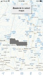
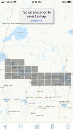
Getting to the place where you can select portions of a map to download is a bit tricky. You should be able to see the base map when you open the App. If you can't see the base map then you are likely zoomed in too much and you have to zoom out until you can see the base map. You have to be zoomed in to the right distance in order to be able to select sections of the map to download. Once you have the base map visible, go to the area where you would like to download sections of map. The App will have a message near the top of the screen that says, "Zoom in to select maps". You start zooming in until you get a message that says,

"Tap on location
to select a map
Select All". (Note: I doubt that you'll want to download All of the sections of the base map so ignore this option)

Once you get that message you can tap the screen and a small square will be highlighted in grey. You can highlight as many sections as you need.
After you have selected one or more sections, near the top of the screen it will say,

"Download
1 Selected Map
Clear Selection"

Of course, if you selected more than 1 Selected Map, it will say 2 Selected Maps, etc. When it says "1 Selected Map" it really means "1 section of a map" (or 2 Selected Maps means 2 sections of a map, etc.). If you accidentally tapped a section that you don't want then you can Clear Selection. When you have highlighted the sections of the map that you want to download you can tap the Download button and it will download the section of the map to the memory on your iPhone.
You have to download the maps and have them on your phone before you go on your trip so that you don't need to have cell service to use the app. (When I'm on a trip I turn my phone to Airplane Mode to preserve battery life). The maps don't seem to take up a lot of space on the phone and, if you don't want them after you return, you can delete them.
As you notice, once the sections you need are downloaded to your phone you can really zoom in on them just like looking at a real topo map.
It won't ask for any money.
Hope this helps.
 
You can use the free version of CalTopo to make maps of any scale you want. They are georeferenced pdf files that you can save to your device's memory. CalTopo lets you add icons for campsites, parking areas, water sources, and most anything else you want.

Then you can use the Avenza app to read the maps in the field, with out a cell phone connection. You can still find your location using the device's GPS.

I like to use my tablet for maps because the larger screen shows more detail. My tablet has an older version of Android that does not play well with the current Avenza. I had to look around on the Avenza site to find a legacy version of the app.
 
Last edited:
Thank you, recped and Ralph.

I am thinking Cal Topo is beyond my level at this point, even with the kind instructions.

Ralph, I am working my way through your instructions. Thank you.

For everyone, it's like reading in a foreign language, what you all are writing. Even if I know the definitions of all the words, I can't figure out the overall meaning.

I have a long lag phase in learning something new. (I'm also trying to learn zoleo. Spent an hour with tech support this morning. There is only so much tech stuff my brain can absorb before it just shuts down.)
 
Understood, Erica!

It's probably best to learn one thing at time and concentrate on Zoleo, since that's your emergency communication. You already know how to find your way with the paper maps.
 
Inspired by your question, I revived my quest to add maps and GPS to my phone. I downloaded the Avenza app, purchased the Quetico map set for $2.99, and downloaded the Quetico campsite locations and portage landings from Paddleplanner. Unfortunately, the are no lake names and the portage landings don't include tracks that connect the two. I think I'll go 'old-school' on my trip next week.
 
Getting to the place where you can select portions of a map to download is a bit tricky. You should be able to see the base map when you open the App. If you can't see the base map then you are likely zoomed in too much and you have to zoom out until you can see the base map. You have to be zoomed in to the right distance in order to be able to select sections of the map to download. Once you have the base map visible, go to the area where you would like to download sections of map. The App will have a message near the top of the screen that says, "Zoom in to select maps". You start zooming in until you get a message that says,

"Tap on location
to select a map
Select All". (Note: I doubt that you'll want to download All of the sections of the base map so ignore this option)

Once you get that message you can tap the screen and a small square will be highlighted in grey. You can highlight as many sections as you need.
After you have selected one or more sections, near the top of the screen it will say,

"Download
1 Selected Map
Clear Selection"

Of course, if you selected more than 1 Selected Map, it will say 2 Selected Maps, etc. When it says "1 Selected Map" it really means "1 section of a map" (or 2 Selected Maps means 2 sections of a map, etc.). If you accidentally tapped a section that you don't want then you can Clear Selection. When you have highlighted the sections of the map that you want to download you can tap the Download button and it will download the section of the map to the memory on your iPhone.
You have to download the maps and have them on your phone before you go on your trip so that you don't need to have cell service to use the app. (When I'm on a trip I turn my phone to Airplane Mode to preserve battery life). The maps don't seem to take up a lot of space on the phone and, if you don't want them after you return, you can delete them.
As you notice, once the sections you need are downloaded to your phone you can really zoom in on them just like looking at a real topo map.
It won't ask for any money.
Hope this helps.
I followed your instructions. I can get through downloading the maps. I downloaded 9 maps around Gull Bay, ON.

Where do I find these downloaded maps?

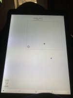
I tried clicking on the icons along the bottom, but that does not seem to help. In fact, I am now stuck in one and can’t get back to the maps. The screen shot looks like this:

1690065864217.jpeg
How do I get back to the maps?

Thank you.
 
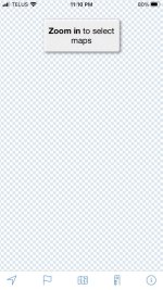
It looks like your base map is off the screen. I played around a bit and I could get the same screen if I moved the base map off of the screen. I think you have inadvertently moved the base map off the screen.


Screenshot 2023-07-22 at 11.10.13 PM.jpg

To get it back, try this:

Zoom out as much as possible.
Move the screen around as much as possible each direction - up, down, left, right.

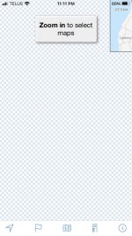
The following picture shows the base map almost hidden off to one side just to show you what I think you have done.

Screenshot 2023-07-22 at 11.11.08 PM.jpg
Hopefully, you will find the base map. Let me know if you can't find it.

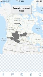
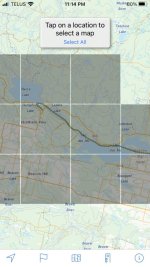
Once you have found the base map, go to the general area where you marked and downloaded the map sections. Those downloaded sections will initially appear as grey circles then grey squares on the base map. You will be able to zoom in on those downloaded sections.

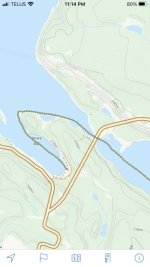
The following pictures are showing how the map looks after you have downloaded some map sections. The pictures show increasing levels of zooming in. The last picture shows how close you can zoom in on the map sections that you have downloaded. FYI, the chain of small yellow circles on the last two pictures is a recorded track.


Screenshot 2023-07-22 at 11.12.15 PM.jpg

Screenshot 2023-07-22 at 11.13.01 PM.jpg

Screenshot 2023-07-22 at 11.13.32 PM.jpg

Screenshot 2023-07-22 at 11.14.22 PM.jpg

Screenshot 2023-07-22 at 11.14.56 PM.jpg
 
Thank you, Ralph. I’ll see what I can do.

Ok. I get it now. Navigation through the maps is by zooming in and out.

And once in a block of maps, I can move seamlessly through them. When I hit the little squares,
I’ve run out of the saved maps.

And the downloaded maps are in the app, accessible when offline.

I suppose this is easy and intuitive for most, but not for me. Thank you for your patience.
 
Last edited:
Thanks all fort this educational info. The online availability of these maps is wonderful. I recall waiting weeks for topo maps to come in the mail, or going to the public library pulling drawers of maps.
there is something to be said for paper map and compass tho!
 
Back
Top