G
Guest
Guest
The Fishfinder is a keeper, whether or not I ever do any fishing (I hear Glenn laughing in a knowing manner).
The test paddle had a few complications, Tuesday I drove up to meet the family, already camped at a PA State Park lake; the Fish Commission launch permit being valid in PA State Parks as well.
I didn’t drive far. 10 miles into PA, a whopping 16 miles from my home, the highway came to a dead stop. Engine off, windows open for a solid hour dead stop. I should have brought the newspaper; instead I re-read the Tacoma’s Owner’s Manual. I may toss some old paperback in the truck, just to be safe for emergency reading material.
Followed by another hour of creeping forward a few feet at 2mph, not sure which was worse. The inter-State was shut down, all traffic re-routed onto a side road. A side road through small town traffic signals, now carrying thousands of vehicles, still creeping along at 2mph.
I said a very bad word, and was back home in 20 minutes. (Sorry, I needed a little misfortune rant)
Wednesday poured buckets, but Thursday was a decent weather day, the canoe was still racked and gear packed, so I headed to the upper Conowingo Pool, to use my permit at the Muddy Run Fish Commission launch.
The Conowingo “pool” was more of a moving river when I arrived, but I was soon upstream into the interesting areas where the current runs slower. Looking upstream into the rock formations between Peavine Island (actually more of a peninsula) and Upper Bear Island.
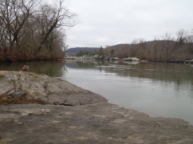 P3240004 by Mike McCrea, on Flickr
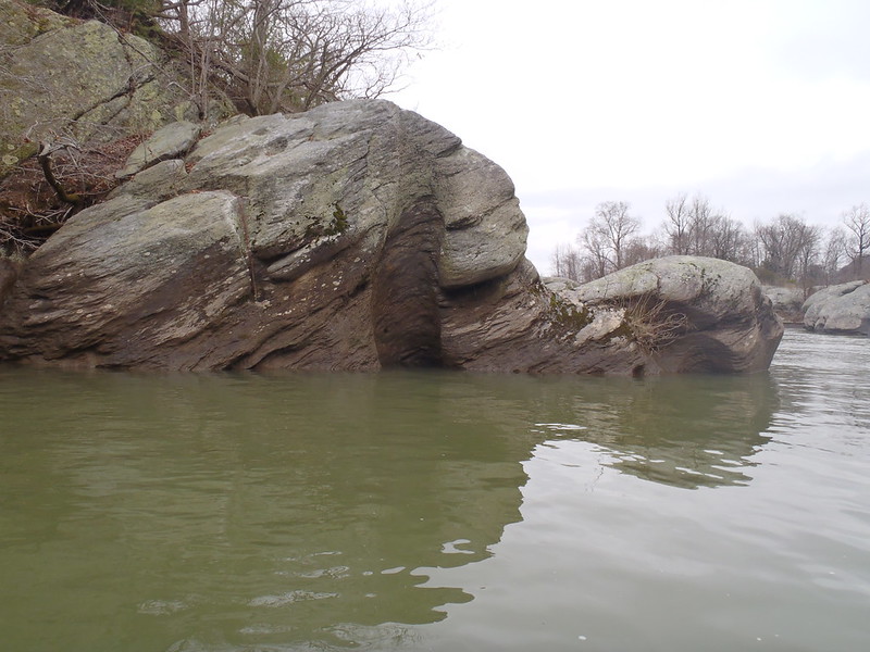
Getting into the rocky shoreline, some of the thousands of whirls and potholes become visible.
 P3240007 by Mike McCrea, on Flickr
Up close the broken out whirls along the shoreline rock edges are everyfreakingwhere.
 P3240009 by Mike McCrea, on Flickr
 P3250010 by Mike McCrea, on Flickr
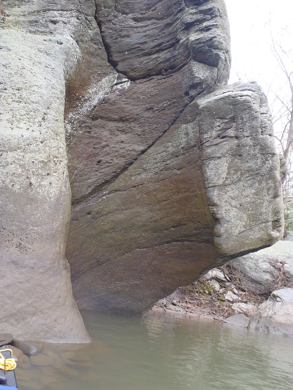
Including the mother of all whirls.
 P3250011 by Mike McCrea, on Flickr
Seriously, how long to rock swirl scrape out a hole like this?
 P3250014 by Mike McCrea, on Flickr
The eons required for current to swirl small stones in a depression and create those potholes is awesome to think about. There are intact potholes atop the cliffs (flood stage on the natural river course?); some circular cooking pot sized, some the size of a washer drum, fully 20 feet above pool level, with rainwater, little round stones and, in summer, weird invertebrate life.
I could probably have some educational fun there with a magnifying glass and a field guide. Maybe next time; I have a good magnifying glass, and know what I want for my birthday.
https://www.amazon.com/Field-Freshwa...20694574&psc=1
(That peculiar Zoology nerd activity may be likelier than me getting a fishing license)
My usual cross-over attainment routes, east towards to the Lancaster County side, between Crow and Upper Bear, or between Upper and Lower Bear, were a no-go of frothy whitewater and standing waves. I have witnessed spectacular yard-sale capsizes in both those areas with much less current (Chip once, C2G twice). Nope, not today.
Time for a leg stretcher on one of the cobble beaches.
 P3250015 by Mike McCrea, on Flickr
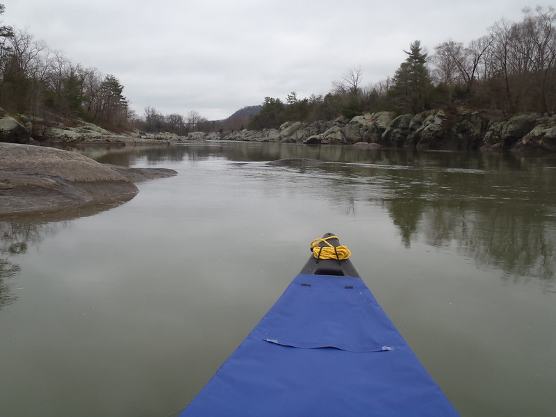
The wind began to pick up from the south, but there seemed to be an increasing amount of current to ride downstream. Down to the end of Peavine Island to do a 180 and explore further. Not really an “explore”; I’ve paddled there most of my life, and know every rock, spring, stream and beach.
I encountered my second person on the (usually busy) water at the tip of Peavine, a kayak fisherman, and paddling nearer, said “I don’t want to disturb you, but I could use some eyes on my canoe”.
Trim checked by the yakker the Fishfinder was (said to be) a touch bow-light, just as I wanted. Even better the ‘yak fisherman paddled over, inspected the Fishfinder outfitting and approved. He didn’t even see the sail, and I think I could have sold it to him then and there, but I was starting to really like the soloization rebuild.
Everything in that retrofitted canoe is functional (I did not have fishing rods, don’t even have a license yet) and located in the right position. The Fishfinder flat-spins 180 with a few strokes, and with a length-to-waterline of 5+ is not a complete pig to paddle. Plenty of depth as a solo (13 ½”) and plenty of rated capacity (820lbs). It’s a keeper even if I never fish.
Up the calm water behind Peavine Island. More whirls aplenty.
 P3250017 by Mike McCrea, on Flickr
That little stretch of river is endlessly fascinating. And we’re not done yet. The hidden paddle-in grotto at the NW tip of Big Chestnut and the battleship-prow cliff on Wolf Island await. The SE wind is picking up. So is the current, and the pool level is slowly dropping; Conowingo must have gates open.
Eh, the hidden grotto and ship-bow cliff will have to wait. Where the main stem current crosses over east to west between Lower Bear and Big Chestnut is now running fast, and there are whitecaps at the grotto entrance.
That’s a nope, but at least I can ride the flow downstream, duck out of the current and sail back up.
 P3250019 by Mike McCrea, on Flickr
When it is possible to attain between the York and Lancaster county sides that circle route, calm waters north, attaining to flowing waters south is a joy, and the east side of Upper Bear has some nice sandy beaches and rock outcropping mini-islands.
I was rewarded with that near effortless float down/sail back. I could do that all day, but I wanted a look at some of the old locks and aqueducts from the Tidewater & Susquehanna Canal. That man-laid stonework is also way cool to think about.
 P3250022 by Mike McCrea, on Flickr
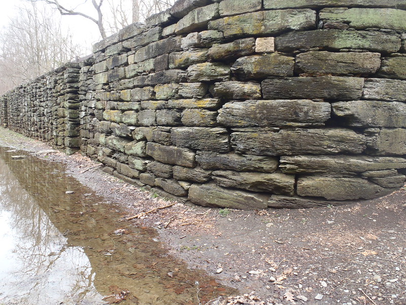 P3250024 by Mike McCrea, on Flickr
Erected with nothing but sweat, muscle, men and mules in the 1830’s, and done in like many canals by the railroads 40 years later.
https://en.wikipedia.org/wiki/Susque...idewater_Canal
On another positive note, back at the take out I received more validation for the Fishfinder. When I walked back from the truck after landing a sightseeing couple at the launch had become fascinated with the canoe, and the lady was taking photos.
I believe I could have sold the Fishfinder twice that day. And I want to thank Glenn again for passing on it. Although I still want the same-ish size in 20lbs lighter composite.
Time to head home. But first, a short drive up to have a look at Holtwood dam. There was a fair amount of water coming across the entire top of the spillway, not just through the gates on the Lancaster side, which helps explain the current. The previous day’s rain had swollen the Susquehanna, and the Conowingo Dam didn’t need to worry about running their eleven giant hydroelectric turbines, and later refilling the pool.
https://en.wikipedia.org/wiki/Conowingo_Dam
That Holtwood spillway and Conowingo gates makes for a tricky combination to calculate. The USGS gauge for Conowingo will go straight up and straight down as they open gates to run the turbines.
https://waterdata.usgs.gov/pa/nwis/u...65,00060,00010
Where was I that Thursday morning? At 16 feet and eightysome thousand CFS. That dang dam stuff is as complex as figuring out windblown tidal waters, but at least I know where the “sneak” routes are.
 P3250027 by Mike McCrea, on Flickr
No wonder I nixed any foolish attainment attempt.
All I all the day could hardly have been better. The launch is 42 miles of scenic back road from my home. 42 miles that, from ages 8 to 18 I rode along as a kid, drove, hitchhiked and even walked* twice in my youth.
*I walked it a couple times just for the hell of it. 2+ days with a backpack, with longhair hippie freak brethren routinely stopping to ask if I wanted a ride. And understanding when I said “Thanks, but I’m just having a bit of a walkabout”.
Best memory of a hike there with a friend; we got off to a late start and kept walking into dark to make up distance. We came to some open farm fields along a stream, hopped a couple fences away from the road and found a nice, level grassy spot near the stream ideal to set up the tent.
Fortunately we awoke early the next morning. We were camped, in plain view, on the expansive front lawn of a mansion atop the hill. We might have set the world record for taking down a Eureka Timberline.
Well, OK, that familiar day paddle could have been a little better. I was hungry, and had to bypass one of my favorite diners just a few miles down the road en route home.
 P3250029 by Mike McCrea, on Flickr
dang Covid; I wanted me an open face roast beef sandwich and mashed potatoes, gravy over everything please. And maybe a slice of homemade pie.
Thanks for bearing with my much ado about nothing trip report. ALSG, and a couple other local paddlers whom I provided a photocopy of the area topo map, what’s keeping you?
I will add one more area visitor suggestion. When you are done paddling drive north along River Rd beside the Susquehanna, cross over Rte 372, drive past the Lock 12 sightseer area and continue towards Holtwood dam.
The last concrete-on-dirt-road bridge you pass before the dam has a small pull off area (I know, horrible oops-you-passed-it directions, just turn around near the dam and head back), is the unmarked trailhead one of the most scenic, short streamside hikes anywhere, through a veritable forest of Mt. Laurel and waterfall cascades.
Bring your camera.
The test paddle had a few complications, Tuesday I drove up to meet the family, already camped at a PA State Park lake; the Fish Commission launch permit being valid in PA State Parks as well.
I didn’t drive far. 10 miles into PA, a whopping 16 miles from my home, the highway came to a dead stop. Engine off, windows open for a solid hour dead stop. I should have brought the newspaper; instead I re-read the Tacoma’s Owner’s Manual. I may toss some old paperback in the truck, just to be safe for emergency reading material.
Followed by another hour of creeping forward a few feet at 2mph, not sure which was worse. The inter-State was shut down, all traffic re-routed onto a side road. A side road through small town traffic signals, now carrying thousands of vehicles, still creeping along at 2mph.
I said a very bad word, and was back home in 20 minutes. (Sorry, I needed a little misfortune rant)
Wednesday poured buckets, but Thursday was a decent weather day, the canoe was still racked and gear packed, so I headed to the upper Conowingo Pool, to use my permit at the Muddy Run Fish Commission launch.
The Conowingo “pool” was more of a moving river when I arrived, but I was soon upstream into the interesting areas where the current runs slower. Looking upstream into the rock formations between Peavine Island (actually more of a peninsula) and Upper Bear Island.
P3240004 by Mike McCrea, on FlickrGetting into the rocky shoreline, some of the thousands of whirls and potholes become visible.
P3240007 by Mike McCrea, on FlickrUp close the broken out whirls along the shoreline rock edges are everyfreakingwhere.
P3240009 by Mike McCrea, on FlickrP3250010 by Mike McCrea, on FlickrIncluding the mother of all whirls.
P3250011 by Mike McCrea, on FlickrSeriously, how long to rock swirl scrape out a hole like this?
P3250014 by Mike McCrea, on FlickrThe eons required for current to swirl small stones in a depression and create those potholes is awesome to think about. There are intact potholes atop the cliffs (flood stage on the natural river course?); some circular cooking pot sized, some the size of a washer drum, fully 20 feet above pool level, with rainwater, little round stones and, in summer, weird invertebrate life.
I could probably have some educational fun there with a magnifying glass and a field guide. Maybe next time; I have a good magnifying glass, and know what I want for my birthday.
https://www.amazon.com/Field-Freshwa...20694574&psc=1
(That peculiar Zoology nerd activity may be likelier than me getting a fishing license)
My usual cross-over attainment routes, east towards to the Lancaster County side, between Crow and Upper Bear, or between Upper and Lower Bear, were a no-go of frothy whitewater and standing waves. I have witnessed spectacular yard-sale capsizes in both those areas with much less current (Chip once, C2G twice). Nope, not today.
Time for a leg stretcher on one of the cobble beaches.
P3250015 by Mike McCrea, on FlickrThe wind began to pick up from the south, but there seemed to be an increasing amount of current to ride downstream. Down to the end of Peavine Island to do a 180 and explore further. Not really an “explore”; I’ve paddled there most of my life, and know every rock, spring, stream and beach.
I encountered my second person on the (usually busy) water at the tip of Peavine, a kayak fisherman, and paddling nearer, said “I don’t want to disturb you, but I could use some eyes on my canoe”.
Trim checked by the yakker the Fishfinder was (said to be) a touch bow-light, just as I wanted. Even better the ‘yak fisherman paddled over, inspected the Fishfinder outfitting and approved. He didn’t even see the sail, and I think I could have sold it to him then and there, but I was starting to really like the soloization rebuild.
Everything in that retrofitted canoe is functional (I did not have fishing rods, don’t even have a license yet) and located in the right position. The Fishfinder flat-spins 180 with a few strokes, and with a length-to-waterline of 5+ is not a complete pig to paddle. Plenty of depth as a solo (13 ½”) and plenty of rated capacity (820lbs). It’s a keeper even if I never fish.
Up the calm water behind Peavine Island. More whirls aplenty.
P3250017 by Mike McCrea, on FlickrThat little stretch of river is endlessly fascinating. And we’re not done yet. The hidden paddle-in grotto at the NW tip of Big Chestnut and the battleship-prow cliff on Wolf Island await. The SE wind is picking up. So is the current, and the pool level is slowly dropping; Conowingo must have gates open.
Eh, the hidden grotto and ship-bow cliff will have to wait. Where the main stem current crosses over east to west between Lower Bear and Big Chestnut is now running fast, and there are whitecaps at the grotto entrance.
That’s a nope, but at least I can ride the flow downstream, duck out of the current and sail back up.
P3250019 by Mike McCrea, on FlickrWhen it is possible to attain between the York and Lancaster county sides that circle route, calm waters north, attaining to flowing waters south is a joy, and the east side of Upper Bear has some nice sandy beaches and rock outcropping mini-islands.
I was rewarded with that near effortless float down/sail back. I could do that all day, but I wanted a look at some of the old locks and aqueducts from the Tidewater & Susquehanna Canal. That man-laid stonework is also way cool to think about.
P3250022 by Mike McCrea, on FlickrP3250024 by Mike McCrea, on FlickrErected with nothing but sweat, muscle, men and mules in the 1830’s, and done in like many canals by the railroads 40 years later.
https://en.wikipedia.org/wiki/Susque...idewater_Canal
On another positive note, back at the take out I received more validation for the Fishfinder. When I walked back from the truck after landing a sightseeing couple at the launch had become fascinated with the canoe, and the lady was taking photos.
I believe I could have sold the Fishfinder twice that day. And I want to thank Glenn again for passing on it. Although I still want the same-ish size in 20lbs lighter composite.
Time to head home. But first, a short drive up to have a look at Holtwood dam. There was a fair amount of water coming across the entire top of the spillway, not just through the gates on the Lancaster side, which helps explain the current. The previous day’s rain had swollen the Susquehanna, and the Conowingo Dam didn’t need to worry about running their eleven giant hydroelectric turbines, and later refilling the pool.
https://en.wikipedia.org/wiki/Conowingo_Dam
That Holtwood spillway and Conowingo gates makes for a tricky combination to calculate. The USGS gauge for Conowingo will go straight up and straight down as they open gates to run the turbines.
https://waterdata.usgs.gov/pa/nwis/u...65,00060,00010
Where was I that Thursday morning? At 16 feet and eightysome thousand CFS. That dang dam stuff is as complex as figuring out windblown tidal waters, but at least I know where the “sneak” routes are.
P3250027 by Mike McCrea, on FlickrNo wonder I nixed any foolish attainment attempt.
All I all the day could hardly have been better. The launch is 42 miles of scenic back road from my home. 42 miles that, from ages 8 to 18 I rode along as a kid, drove, hitchhiked and even walked* twice in my youth.
*I walked it a couple times just for the hell of it. 2+ days with a backpack, with longhair hippie freak brethren routinely stopping to ask if I wanted a ride. And understanding when I said “Thanks, but I’m just having a bit of a walkabout”.
Best memory of a hike there with a friend; we got off to a late start and kept walking into dark to make up distance. We came to some open farm fields along a stream, hopped a couple fences away from the road and found a nice, level grassy spot near the stream ideal to set up the tent.
Fortunately we awoke early the next morning. We were camped, in plain view, on the expansive front lawn of a mansion atop the hill. We might have set the world record for taking down a Eureka Timberline.
Well, OK, that familiar day paddle could have been a little better. I was hungry, and had to bypass one of my favorite diners just a few miles down the road en route home.
P3250029 by Mike McCrea, on Flickrdang Covid; I wanted me an open face roast beef sandwich and mashed potatoes, gravy over everything please. And maybe a slice of homemade pie.
Thanks for bearing with my much ado about nothing trip report. ALSG, and a couple other local paddlers whom I provided a photocopy of the area topo map, what’s keeping you?
I will add one more area visitor suggestion. When you are done paddling drive north along River Rd beside the Susquehanna, cross over Rte 372, drive past the Lock 12 sightseer area and continue towards Holtwood dam.
The last concrete-on-dirt-road bridge you pass before the dam has a small pull off area (I know, horrible oops-you-passed-it directions, just turn around near the dam and head back), is the unmarked trailhead one of the most scenic, short streamside hikes anywhere, through a veritable forest of Mt. Laurel and waterfall cascades.
Bring your camera.

