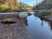
During the recent Adirondack Classic 90 mile Canoe Race, September 5-7, I noticed the water level was notably lower than normal, but in most places not by a great deal. Expecting worse, Brown's Tract seemed to have sufficient water into Raquette Lake, although there were more beaver dams then the usual three major ones, all eight of them were paddleable through. We did not paddle close to South Creek on Middle Saranac Lake, of course, but the river flow between the east end of the lake and the upper lock appeared nearly normal, as did the Marion River on the way to Blue Mountain. On toward the lower lock, through the shallows not much appeared changed from normal if you stay mostly within the red/green buoys.
The end of Long Lake normally features a shallow sand bar with sufficient water coverage into the river. Only twice in 30 years have I ever had to put feet out to float the canoe over the sand bar, including this time for a few yards. The normally shallow parts of the river were shallower than normal, but not really any significant problem, you had to watch for the occasional normally hidden rock now poking its head close to or above the surface.
Day3 on Upper Saranac Lake, I discovered a previously unknown to me rock, a couple hundred meters north of Doctor's Island surprised me in what is expected to be deep open water. I should have paid more attention to what appeared from the bow to be an odd wind swirl on the surface. Luckily, we only just brushed the barely subsurface rock with our paddles on our right side. I fear someone behind us would likely have struck it head on directly. In all my years of paddling though, I had never known that rock was there, just waiting to surprise someone with a serious bang.