• Happy Weed Appreciation Day! 🌱🌿🌻

A first-ever canoe trip across the State of Rhode Island

Joined
Aug 2, 2011
Messages
247
Reaction score
49
Location
Scituate, RI
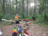
This past July I completed an epic trip, and it deserves an epic trip report. I therefore ask for patience over the weeks as I get it put here. I probably won’t even get the first couple days on here before I head off on another vacation, but hope is eternal and so will be the wait unless I get it started. So here goes.

The trip in question was the first-ever successful navigation completely across the State of Rhode Island, north to south, using a primarily inland route. It was not the first attempt, though. The first attempt was made by two college kids, aged 19 and 20, who decided on a whim in 1958 to have a summer adventure paddling across the state in a wood and canvas canoe. It was not exactly the smoothest trip in history. They flipped in the first rapids of the Blackstone, got lost somewhere mid-state, had to get at least two rides, ended up on a stream somewhere that was choked with brush and had barely enough water to float a boat…...even had their boat confiscated for a few days by an angry farmer on who’se property they had left their canoe. Despite these issues, and despite the total lack of anything coming close to a good map, they almost did it. They had to pull out about 25 miles short of their goal because one of them had to get back to school.

The second attempt was made by me, last year, and I have to say I fared exponentially worse than those two kids, despite Google Earth, better gear, and a lot more experience. I even had better beer. I and two others were primed and ready to make history. And then along came Tropical Storm Andrea. Although she was downgraded before she hit New England, all of that extratropical moisture got dumped on our tiny state, and the river gauges spiked. Overnight, the Branch River spiked from about 100 cfs to almost 2000 cfs. In this small river, that is well into flood.

At this point, I knew the attempt was over for the year. Even if we made it down a flooded Branch River and Blackstone River, there was no way we were paddling UP a flooded Pawtuxet River, a significant upstream leg. But, the day dawned bright and sunny, we had already planned to paddle the first segment without camping gear, and we were an experienced group with good knowledge of what flood conditions would bring. We figured it would at least be an exciting day trip. And in that, we weren't wrong.

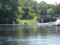
At first, it was a fun, fast ride.

Cross RI 009.jpg Cross RI 008.jpg

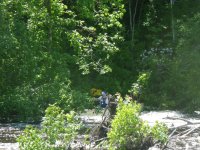
These trestle supports are usually well overhead when we pass through them.

Cross RI 012.jpg

Disaster struck, however, in trying to portage Mohegan Rapid. I had already taken one swim in the preceding rapid, and we were proceeding cautiously. But portaging river left was not an option due to a factory being in the way, and portaging river right took us MOST of the way past the rapid, but put us in a nasty eddy with a must-make ferry past a deadly strainer of trees and branches. Tommy went first and made it. Then Jim went, and didn’t. He had time to go back right before dropping in a channel blocked by two branches on river right, and hung on, trying not to flip. He eventually made it through.

Cross RI 023.jpg

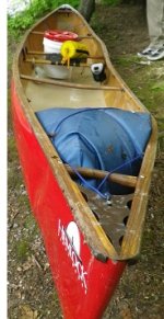
I, on the other hand, did not. As I was ferrying, I was mostly across when the boat just stopped on a surge of water, and I went in and had to swim for my life. I just made it around the edge. My boat didn’t.

Cross RI 025A.jpg

Two days later, when the water had dropped enough for a recovery, this is what my boat looked like.

Cross RI 026A.jpg

Thus ended the second attempt to paddle across the state. Our crew assembled at a nearby friends field to camp and drink some excess beer that we had packed. I resolved to try again, thinking that the chances of being flooded out two years in a row was pretty low. Just to be safe, I scheduled it for the following July. I mean, what are the chances of another hurricane in July?
 

Attachments

  • Cross RI 023.jpg
    Cross RI 023.jpg
    540 KB · Views: 2
  • Cross RI 026A.jpg
    Cross RI 026A.jpg
    50.3 KB · Views: 2
Last edited:
My daughter lives in Bristol and works in Tiverton so I'm really interested as to how this unfolded for you; no pun intended regarding your canoe. I look forward to the rest of your report when you get the time.

That's all for now. Take care and until next time...Be well.

snapper
 
Did the boat go back to Dave Curtis for plastic surgery?

Yes, and he did a fantastic job on her. He actually e-mailed me a couple weeks after the accident, having heard about it, and offered to look at the boat to see if he could fix her. He was racing nearby in West Thompson, CT, so I didn't have far to drive to take the canoe to him. He turned it into a winter project, patching all the holes and tears, replacing the gunnels (I had him install slotted gunnels this time) and even a new Conk Contour seat. He put in a layer of carbon cloth on the interior. Damage is still visible, but the hull is true, and she only gained a pound with the repairs. I drove out to Hemlock to pick her up this spring.

-rs
 
I should preface the trip report with some background information. Two questions probably have arisen already: What’s the big deal with canoeing across Rhode Island? It is, after all, the smallest state in the nation. As one smart@$$ put it, “Sure, but what are you going to do on the next day?”

And why in July?

As to the first question, although mainland RI is, along its longest north-south axis, only roughly 44 miles long (60 if you continue all the way out to Block Island), there is no one continuous river that traverses the whole state. Like, for instance, the Connecticut River does through several states. Sure, one could paddle down the Blackstone River down to Narragansett Bay, and then just cruise all the way down the bay to the ocean, but that’s been done and really, what fun is that? I wanted to do this using a primarily inland route.

Also, there are a lot of obstacles. Thanks to having been ground zero for the Industrial Revolution, Rhode Island is home to a whole lot of dams. Many of them are small, but what many lack in size they make up for in sheer inconvenience with respect to having to portage around them. Finally, the state is not blessed with a lot of canoe-camping sites. There are only two official paddling-accessible campsites in the entire state, and only a handful more of unofficial ones. Finding conveniently located campsites along what turned out to be a 100 mile route through one of the most densely populated states would be a challenge.

As to why the heck I would want to do this in July, the simple answer is: I didn’t. Various other commitments and scheduled events, and even certain superstitions, simply narrowed down our choices to two available weeks in July. We chose the one without a holiday, and just crossed our fingers that we would have enough water in our rivers to float us all the way across.

As a result, I slightly modified my planned route. I originally had planned to start up in the northwest corner of the state, on the Clear & Branch Rivers. While this was not strictly necessary in order to traverse the entire state north to south, those rivers have a special place in my heart, and added to the overall challenge. But there is next to no chance that there would be enough water in those rivers in July to get down them in anything larger than a toy boat, so I scrapped them. Since this would have shortened the trip by about 12 miles, I also decided to extend the southern end of the trip, originally planned for Downtown Westerly, all the way down to a boat ramp in Connecticut on Little Narragansett Bay. A true traverse of the state.

The final route would be a shade over or under 100 miles (unless I do it again and GPS the whole thing, I won’t ever know the exact mileage), touching on ten named rivers as well as Narragansett Bay and a couple ponds, and pass through or by 19 of Rhode Island’s 39 cities and towns, including the capital city of Providence.

The final route would look like this:

PaddleRouteRI.jpg

So I had everything set. A crew of four, including me (three solo canoes, one kayak), the route was set, I had camping for seven nights arranged, PR events set with various groups (as I had last year), and no tropical storm issues on the horizon.

Wait, did I just say there were no tropical storm issues on the horizon? Silly me! With a week to go for launch date, I get an e-mail from one of my companions asking what our plan is if Hurricane Arthur our way comes. WHaaaaAAT? Sure enough, out of a random bunch of reprobate thunderstorms off of Florida, this storm just sprang out and said “Boo!” I was like, “are you friggin’ kidding me? Two years in a row? Come ON!”

I watched while it turned into a tropical storm, and then a hurricane, and then a Category 2 hurricane, and waited for it to turn off shore and head for England. But he never did. Instead, he marched right up the coast, arriving two days before our planned departure. I spent a lot of time swearing, and planning additional portage routes to get around flooded rivers, because I’d be danged if I was going to try this trip for a THIRD time. The cohesion of my team started to waver.

But fortunately, Arthur dumped the vast majority of his rain on Cape Cod and the Islands, sending most of the state only 2 ½ inches or so, and giving some very dry rivers a nice bump up to a friendly paddling level.

So don’t knock hurricanes, they ain’t all bad.
 
Day 1: Blackstone River, North Smithfield to Central Falls

When I arrived at our put-in at The Meadows town park, Billy and his sister were already there. As I started to unload, our friend Tommy, who was part of last year’s attempt but unable to accompany us the whole way this year, came by to wish us a good journey. Soon enough, Jim and Dave arrived with our friend Jim Schoer (who, although he did not know it at the time, was going to save one of us from having to prematurely leave the trip).

The trip would start out with a semi-portage, since the river was not right next to the parking lot. We first had to haul our boats and gear across a softball field, and then through some floodplain grasslands to reach the riverbank. We put in right where the Blackstone River flows into Rhode Island from Blackstone, Massachusetts. While we packed, hauled, and got ready to launch, we were interviewed by Rhode Island Public Radio and the Woonsocket Call (the local newspaper), a continuation of some fairly good press coverage we had gotten as the launch date approached.

The crew, L-R: Jim Cole, Chuck Horbert (me), Dave Smith and Bill Luther
IMGP1156.JPG

With the boats packed, interviews done, photos taken, and good-byes made to friends and family, we were off! It was a gorgeous, sunny day, and the river seemed to be at a good level. The scenery was not that great to start out with, since this portion of the river is basically confined by flood control levees and industrial lots.

IMGP1158.JPG

We had barely left the first mile behind when we arrived at the take-out for our first portage (or second, if you count the put-in) to get around the Woonsocket Falls hydro dam. Tommy, and my wife Cindy, were there to meet us and, right after we got our boats loaded on the carts, Delilah also arrived. She was our first “Facebook” fan to find us. She was super excited, and we obliged by posing for photos. As we walked along the city streets, we picked up a couple other fans as well…it was like a small canoe parade!

IMGP1160.JPG

Soon enough, we were at the boat launch at River Island Park and, after scouting from the nearby Bernon Street Dam to look over the first set of rapids, we were off. The next half mile or so of the Blackstone contains fairly straightforward Class II rapids which, thanks to the recent rains from Hurricane Arthur, weren’t too scratchy. As we reached the end of the last set, I heard cheering from a nearby apartment building! It was a high school pal, Darren, who’s Dad’s apartment overlooks the river. He greeted us with cheers and a home-made sign none of us could read.

IMGP1163.JPG

Eventually the river swung back and headed south, and the riverbanks gradually transitioned from rip-rap slopes to forest and wetland. As we paddled into Cumberland and Lincoln, a canoe approached us from downstream…another friend, Erik had decided to join us for a short paddle! Erik is good people and I always enjoy paddling with him.

When we reached the take-out for the portage Manville Dam (accomplished via a bike path) we were met by a few members of the Blackstone River Watershed Council as well as my aunt and uncle, who live nearby! Another canoe/kayak parade was quickly formed, and down the bike path we went. Along the way, random people would stop and ask if “We were the guys paddling across the state?” Good press indeed. As we neared the end of our portage, my pal Darren, joined by his wife Doreen, met us fence-side, and this time we could see what the sign that he had been holding up earlier.

Rolling into Sycamore Landing Educational Center
IMGP1165.JPG

We all rolled our canoes right into the “Sycamore Landing” education center run by the Blackstone River Watershed folks, where we had an impromptu gathering. I said a few words about the great work that the BRWC is doing to promote stewardship of and access to the Blackstone River and its tributaries and, for their part, they fed us a fantastic lunch! We filled up water bottles, and hit the river again, joined by BRWC president John Marsland and his daughter.

They accompanied us all the way to Albion Dam, where they turned around and we got out again to hoof it around another dam. As we were shuttling all of our gear down the short path, we ran into a bicyclist who looked vaguely familiar…it turned out to be another acquaintance, Mike, a former President of the RI Canoe & Kayak Association (as were three of us) and paddling friend. He turned out to be one of the few people who had not heard of our trip, so we blew him away with our plans.

Leaving Albion Dam
IMGP1172.JPG

Back on the river, we paddled our way south, passing under the bridges for Interstate Rte 295 (a highway we would pass under again in two more days), and eventually reaching Alton Dam. While planning the trip, I had two options here. River left would be a longer portage, and would place us back on the river, where we would enjoy a few easy rapids but have a crappy take-out and steep climb at the next portage. The river-right portage was short, intense, poison-ivy infested and rocky, but it put us onto one of the few intact remaining stretches of the historic Blackstone Canal. We chose history.

A short, but rough, portage
IMGP1175.JPG

This canal was built by hand over three years connecting Worcester, MA to Providence, RI when it opened in 1828, bringing quick prosperity to merchants in both cities. Seven year later, however, the first rail line connecting the cities was opened, and 13 years after that the canal was closed. Most of its length has been filled, breached or otherwise absorbed into the surroundings. The four mile stretch we used is one of the longest intact stretches left, and provides a pleasant flatwater path southward even now, over 175 years after its construction.

IMGP1185.JPG

After we passed under the beautiful George Washington Viaduct, we stopped at Kelly house, formerly owned by Captain Wilbur Kelly, who revived an old mill in the area in the era of the Blackstone Canal and who also, in his days as a young sea captain, set a record sailing to Canton, China and back. The Kelly House is a museum now that is part of the Blackstone Valley National Heritage Corridor and run by my employer, the RI Department of Environmental Management. Ranger Victoria gave us a tour and provided us with bottles of water. It was a nice break.

Kelly House
IMGP1183.JPG

As we continued our way down the canal, which runs right next to the bike path, we continued to run into folks who had heard about us either on Facebook or in the news, and all offered us encouragement. We took out at an easy access where the Lonsdale entrance of the bike path crosses the canal, a nice grassy area where we lounged for a while. In what was to be a consistent trend, we were early for our next planned stop at an outfitters shop where we would trade paddling stories with his customers for food (the owner planned an outdoor cooking demonstration), so we slacked here on the grass for a while.

The end of the canal:
IMGP1188.JPG

While there, we ran into a guy walking his pet …lizard. I can’t remember what kind of lizard he called it (yellow collared mack dragon, or something), but it just rode along on his t-shirt. Like us, he was just out doing cool things.

P7060087.JPG

Eventually, we got off our asses and portaged our way across the Pratt Dam and back onto the main river and, quickly thereafter, pulled out at Blackstone Valley Outfitters where we were greeted by no fanfare at all. In fact, an employee was taking down the “open” sign. Huh? It turns out he knew nothing of our arrival. The owner had evidently forgotten about the trip! Which I found to be incredible considering the boost he could have given his poor store with a little advertising and marketing giving customers a chance to meet us and ask canoe-camping questions. To this day, I have not heard what happened.

Well, looks like supper is up to us! We were only a couple miles away from our last portage of the day, one that would take us right into our campsite for the night, so we hopped back in the boats and got e’r done, paddling through Lonsdale Marsh and arriving at Central Falls Landing on the Cumberland/Central Falls line about 20 minutes later.

During the previous portage, my portage cart (in keeping with its usual modus operandi) developed a flat, and it was clear that it was not going to stay inflated long enough to get me to camp. Fortunately it was a fairly short portage (about 0.4 miles), so I wheeled Jim’s boat to camp with the others while Jim stayed behind to watch my stuff. I then took his cart back with me to get my boat. While this was happening, our friend Mike arrived to join us for a spell at camp.

The bridge to our campsite:
P7070092.JPG

River Island Campground, located on an island in the river and accessible by footbridge from a nearby park, recently opened, and is one of only two official canoe camping sites in the entire state. It is an odd location for a campsite, in Central Falls, a densely populated city of many ethnic cultures and peoples. The smallest city in the state, Central Falls unfortunately has a bad rep, but honestly is making great strides in livability under bad economic conditions.

Other than the fact that the campfire pit was completely filled with trash and bottles, and the site littered with broken glass, it was a pretty nice site. We had ample room to spread out, with picnic tables to hang out on. The park had a bathroom facility to which, by prior arrangement, I had the key. This was very good, because finding any private place on that island for morning ablutions would have been near impossible, and probably would not be healthy.

We broke open some beers, cooked some dinner, and had a pleasant evening just re-living the day. It had been a long day, so we did not bother with a campfire. I replaced the tube in my portage cart wheel with the spare I had brought along. Life was good.

Camp for the night:
IMGP1198.JPG
The river nearby:
IMGP1201.JPG

One other feature of the campsite we experienced, first at 11:00 pm and again around 2:30 am, is a nearby freight track. Between rattling cars, rattling bridges, brakes and airhorn greetings, no one slept through.

Mileage for the day: about 14.1 miles.
 
Last edited:
I take great pride in knowing that my work lessens the soreness of asses across this great land. In addition, it is good to know that your morning ablutions were safe and sanitary.
 
Day 2: Central Falls, down the Blackstone, Pawtucket and Seekonk Rivers and a bit of Narragansett Bay to "The Oxbows" State Park on the Pawtuxet River, Cranston, RI

On these sorts of long distance canoe trips, it is usually nice to wake up knowing that there is no rain in the forecast. But today, rain was the least of my worries and, as it turned out, would have been welcome towards the end of this day. Before the trip, during press interviews, when I was asked the question as to what I thought our toughest challenges would be, this day’s segment was usually in the top 3. Owing to the inflexibility of my schedule, and thanks to the departing low pressure system that was Hurricane Arthur, we would have to face both incoming tides and headwinds.

But I am getting ahead of myself. There was a lot to happen before we got to the tidal Seekonk River. So it goes without saying that we were all up early. Probably too early. Like, 5:00 to 5:30 am early. So we had plenty of time to pack up camp, including filling two trash bags full of garbage from out of the campfire pit and around the area. By the time we were done but for launching, it was only 7:30, and we didn’t have to be at our first PR stop for the day, a mere mile downstream, until 9:30. By 8:30 we couldn’t contain ourselves any longer and left our little island to head towards Chocolateville.

Headed downriver to Chocolateville
IMGP1205.JPG

Yes, Chocolateville! There is such a place! Or was. One of the first water-powered chocolate mills in the world was built in Central Falls, which soon became a major chocolate manufacturer. I can just imagine THAT smell! On this morning, we were stopping for a photo op to promote a new canoe access that had been built by the City of Central Falls. At this access is a small park with interpretive signs talking about the history of the mills that used to exist there.

Parked below the Roosevelt Avenue bridge at our first stop
IMGP1206.JPG
Welcome to Chocolateville!
P7070103.JPG

We got there early, of course, and had time to kill, so we were able to read all of the signs (or take pictures of them to read later). While wandering, I investigated an odd looking post that turned out to be a well-equipped bike repair station! We found out later that it was the first one installed in the state, at a point where a designated bikeway passes through. It functioned as a bike repair rack, with all sorts of tools, and even an air pump, all integrated into one unit. I never knew such a thing existed until that day.

Got a bike to fix? We got the tools!
P7070105.JPG

Soon enough, we were joined by some fans (my cousin, and her two daughters), as well as Geraldine from the Blackstone Valley Tourism Council office, who came bearing balloons, and, right on time, James Diossa, Mayor of the City of Central Falls, which is what Chocolateville came to be named. He turned out to be a great guy (he is the guy who pushed for the development of the campground we stayed at, the boat access, and even the bike repair station). He has a tough job…Central Falls is the poorest City in the state…so we were honored he took some time out of his day to come out and meet us.

Mayor Diossa with the PARI Crew
IMGP1209.JPG

After the pictures were taken and the hands were shaken, it was time to get the canoes on the wheels again to head south into Pawtucket, our sixth community of the journey. The day was starting to warm up, so fortunately it was a nice, flat walk down Roosevelt Avenue, past old factories, businesses, community centers, a fire department, City Hall, finally to arrive about three quarters of a mile down the road at Slater Mill, the birthplace of the Industrial Revolution, carrying the dreams of a Recreational Revolution.

Walking down Roosevelt Avenue into Pawtucket
IMGP1210.JPG

Here we participated in what was planned to be the main event for the trip. We were met by a contingent of VIP’s there to talk about rivers in Rhode Island, and the Blackstone River in particular. There was a “cocktail mingle” with juice, water, and power bars. Photos were taken by the paparazzi. We started feeling like rock stars. Then the speeches started. Bob Billington, executive Director of the Blackstone Valley Tourism Council, greeted everyone with visions of the Tourism and Economic Development engine the valley has become and could yet be. Janet Coit, the Director of the state Department of Environmental Management (and my boss), talked about efforts to return anadromous fisheries to the river, and congratulating us on our efforts to highlight the recreational opportunities the State’s rivers had to offer (it was she, not me that coined the term Recreational Revolution). She was followed by Jen Smith and John Monroe of the U.S. National Park Service who talked about the importance and values of water trails, and the hopes that the Blackstone River National Heritage Corridor might one day be designated as a new National Park. I was then invited up to talk about the Big Trip, and how it related to the goals of the Rhode Island Blueways Alliance, of which both Jim Cole and I are board members. I also talked about the efforts of the Watershed Councils and their umbrella group, the Rhode Island Rivers Council, to which both Jim and I had been appointed by the Governor. And I thanked a whole lot of people!

Slater Mill, birthplace of the Industrial Revolution; visited by the Recreational revolution.
P7070110.JPG
RI Rivers Council Members, L-R: Bob Billington, Jim Cole, me and Chairperson Veronica Berounsky
IMGP1211.JPG

After another round of photographs, it was time to hit the road again. We still had Slater Dam and Main Street dam to walk around. During the walk, Dave started experiencing problems with his kayak cart. It kept folding and collapsing on him. Some time was spent tightening straps and readjusting the load, and soon we seemed to get things rolling acceptably.

Our first crossing under Route 95
IMGP1216.JPG

Soon after crossing under Interstate Route 95 (our first of many times crossing either over or under this highway), we reached the Town Landing boat launch on the now-tidal now-named Pawtucket River, which would only be the Pawtucket River for as long as it took us to reach the Pawtucket line, at which time it becomes the Seekonk River. Shortest river ever? Maybe.

The crew hits the tidal waters
DSCN2150.JPG
Leaving Pawtucket behind
IMGP1218.JPG

We generally hugged the shore, which kept us out of the worst of the wind and the strongest tidal currents, and it seemed for a few miles that this stretch wouldn’t be so bad after all. We passed a few features that I will have to research a bit more, including what seemed to be a random, small houseboat, as well as a massive rock promontory that undoubtedly has a story to tell. We also passed Swan Point Cemetery, where my grandparents are still resting until rising sea levels may disturb them. A little after noon we landed on a pleasant shady beach to have some lunch. The wind seemed to be steadily increasing, but was still not too bad.

Who lives here?
IMGP1219.JPG
The remains of...something
IMGP1220.JPG

That would change as we approached a landmark railroad drawbridge that is stuck in the “open” position, the wind picking up as we penetrated deep into the urban center of the state, with East Providence on our left and the state capital, Providence, on our right. Ahead of us was an “S” curve that would take the Seekonk River around Bold Point and into the far upper reaches of Narragansett Bay, our next challenge.

Approaching the end of the Seekonk
IMGP1222.JPG

By the time we reached Bold Point, we were all battling. The wind was definitely making itself felt, and the still-incoming tide wasn’t helping. We pulled up on the beach on the point in the lee of the wind, and walked over it to see what the Bay looked like.

Well. It sure didn’t look good. It was pretty choppy, and a core area in the center was nothing but rippling whitecaps. Easily 30 knot winds. A fleet of small sailboats was in the upper bay, practicing for races, all zipping right along. We still had almost 5 miles to paddle into the teeth of that wind if we wanted to paddle into Pawtuxet Cove to get to our next destination, camp. Our options were limited. We could walk about 2.5 miles along a nearby bike path to get us further down the bay, but that would require ferrying across to the other side of the bay (about .45 miles wide at that point), and still have almost 3 miles to still paddle south to get inside the breakwater, at which time the tide could be going out, and against us again. Or we could paddle across the top of the bay, get out at another boat ramp at Collyer Point to access Allens Avenue and walk all the way south to camp, a 4 mile unplanned portage. Or we could tough it out and just stick to our original plan. After a bit of debate, we decided to paddle to Collyer Point, and make another decision when we got there to either paddle on or get out and walk.

This maneuver alone was about 0.8 miles across the head of the bay, with seas primarily on our beams. Paddling was slow and deliberate. At one point, as Dave and I passed by the dock where the racing sailboats were based, an attendant asked us if we could please paddle further out because a couple boats might come in. It must not have been obvious to him that we were doing everything we could just to keep on our current course. Instead of retorting as each of us wanted to, we simply both authoritatively stated, “No”.

Slow and steady wins the race, and we pulled into Collyer Point boat ramp all convinced we would be walking from there. Well, all except Billy, and he was politely voted down. Back on the wheels the boats went for our last portage of the day.

Headed from Collyer Point to Allens Avenue
P7070121.JPG

And what a portage! Allens Avenue, for the first mile or so, passes through an industrial port area featuring oil tanks, scrap metal recycling companies, industrial wharfs, natural gas pipelines, rail lines, big trucks, and pretty much no shade. It was HOT! We definitely got a lot of odd looks on this walk. I doubt a canoe has EVER walked down the sidewalk of this road. We were soon dying from the heat and humidity, drinking warm water and dreaming of cold beer.

A hot walk in the city
IMGP1225.JPG

When we had arrived at Collyer Point, I had sent an update to the trip’s facebook page, and that turned out to be a good idea. Just before we passed under an on-ramp to Rte 95, a black SUV pulled over next to us, and out stepped a colleague of mine from work, Alisa, who had seen the update and decided to come out to find us and see if we needed anything. “Cold Gatorade and Lemonade!” was the immediate reply. I also asked her if she could find a bicycle tube to replace the one I had used to fix my cart a couple days before. Off went our first “Trail Angel”, and on we walked.

At about the halfway point, and after our second hill (this was no flat portage) we finally reached sections with homes, trees and shade. By then, Alisa had supplied us with drinks and the tire tube, and another friend, Steve (who will appear again in this trip report) had also arrived and brought us ice for the coolers. Trail Angel No. 2!

Trail Angel No. 1, Alisa
IMGP1228.JPG

Trail Angel No. 2, Steve
IMGP1226.JPG

With good directions from Alisa, who lives in the area, we were able to avoid one last hill by crossing over to Broad Street, and turning south again. Soon we were at the roadway that would take us back to the river, and to the Pawtuxet “Oxbows” State Park, where we planned to camp for the night. Home sweet home!

We were able to wheel over the trails and across a tricky footbridge all the way to our campsite, which was basically a wide area where two trails intersected. Beers were opened, tents were erected, supper was prepared, and we had fin chatting with many dog walkers who stumbled upon our camp. Fortunately, many of them had heard about us, so we had no complaints from anyone.

Relaxing after a long hot day
IMGP1229.JPG


We took advantage of camping in an urban area to walk back out to a convenience store for water and cold drinks, and were all pretty much in bed by 9:30. I slept much better this night. Tomorrow, we hit our first upstream segment of the trip.

Mileage for the day: 12 fairly tough miles.
 
Last edited:
Day 3: From “The Oxbows” all the way up the Pawtuxet River to Riverpoint Park at the confluence of the North and South Branches of the Pawtuxet.

Once again we were up early, and were packed and on the river by around 8:10. We hadn’t even started upriver yet when I head a shout from shore, “Hey, is Chuck here?” Another friend of mine, Bob, who had been following our trip on Facebook and who lived in the area had come down to say “hi” and wish us luck. Thanks, Bob!

I prepare to launch as Bill and Dave pack gear
P7080126.JPG

At this time, I was not sure how much we would or would not need good luck. This was another segment of my planned route that gave me angina. I had never before paddled any segment of the main branch Pawtuxet, and it was clear based on my multi-seasonal scouting, aerial photo review, and interview of others familiar with the river that the ease of paddling upstream on it would be very much dependent on flow levels. Too high, and it would be a battle. Too low, and we would potentially be walking our boats up through shallow water. All this, and we had to keep a schedule, needing to paddle 6.5 miles upstream to our first PR event scheduled for 1:00 that afternoon.

Aside from the physical challenges, I did not exactly expect a very pleasant paddle. This river winds its way past the urban core of the state, crossing under multiple highways and past tens of thousands of people and businesses. In the course of a two mile stretch we would pass by three large sewerage treatment plants discharging to the river.

Boy, was I surprised. We all were.

I was immediately optimistic as soon as we got on the river. No unpleasant smells, clam shells lining the very visible bed of the river, and fish swimming about. Flow was evident, but paddling upstream was not bad at all to start off with.

Off we go upstream
IMGP1231.JPG

We hit our first shallow spot just downstream of Warwick Avenue, but it was deep enough to paddle up it and past the bridge with some moderate effort. Jim elected to walk through the shallows a bit to save some energy, which gave me pause as to what to expect upstream since he was by far the one most familiar with this stretch of river. Soon after, we were paddling past the hulking, rusting bridges, walls and buildings of the former Ciba Geigy chemical manufacturing plant, and headed up some stronger current to Belmont Park.

As we rounded a sharp curve near the park, to our astonishment, an adult bald eagle flew out of a tree by the river and headed upstream! Never would I have expected to see one in such a heavily developed area of the state. A few hundred feet later, we flushed it again, and that was the last we saw of it. But not the last of the wildlife we saw.

We spotted painted turtles, mallards, and many birds as we continued upstream, past Elmwood Avenue, the Amtrak line, and Interstate Rte 95 (crossing number 2 for those of you keeping track).

Route 95
Rte 95.jpg

Aside from the constant roar of the traffic (and the occasional jet taking off from the nearby airport), we could have been on any wild river. Forested riverbanks shielded most of the surrounding development from view. We passed the Cranston treatment plant without hardly noticing it. Occasionally, strong currents required paddling with authority.

P7080129.JPG

Before we knew it, we came across our first real obstacle, where the river flows between several rows of old bridge pilings, creating a short rapid. Dave was able to easily attain the drop in his kayak, and as he was wading out into the river to assist the canoeists, I also was able to attain it with only moderate difficulty.

Jim tried next, but was rejected on his first attempt and since he had chosen another channel, he was out of reach for an assist by Dave.
IMGP1235.JPG

Attempt number 2 was successful with a small helping hand.
IMGP1236.JPG

Billy followed suit, and we pulled over on a nearby beach for a break.

At this time, it was very clear that we were progressing well ahead of schedule, so I called ahead to my contact at the Pawtuxet River Authority and Watershed Council to alert them to the fact that we would be arriving at their event closer to noon than one as originally scheduled. That being done, we had a snack, built a monument for a piece of a toy Ninja Turtle using river debris, and continued upstream.

Turtle Power!
Turtle Power!.jpg

Snapping turtles, stinkpots, muskrats, herons…the diversity of wildlife along this river as it flowed along the Route 95 corridor was still astounding. We passed under the twin bridges of Route 37, and through a short section of the river that had been diverted from its original channel back when Route 95 when it had been built. Unless you knew what to look for, it was tough to tell it was a constructed channel. Soon after that, we were past the Warwick treatment plant and arriving at the new boat ramp constructed by the Pawtuxet River Authority a good two hours ahead of schedule.

I have to give a shout out to the good folks of the PRA. Not only had they worked over the last couple weeks clearing any fallen trees out of our way, they provided a phenomenal lunch, with PBJ’s and chicken salad, pasta salad, fruit, water, and powerbars, all from Whole Foods. And they do a ton of good work for as advocates for the watershed.

Lunchtime with the PRA
IMGP1243.JPG

Besides representatives of the PRA, Keith Gonsalves, President of the RI Blueways Alliance, showed up, as did Ginny Leslie, who is considered the mother of the North-South trail, a hiking route that also traverses Rhode Island from north to south. I thought it was a neat juxtaposition to have her there cheering us on. Other members of the PRA were present asking us questions about the trip, as was a reporter for a local newspaper. The paparazzi descended on us again.

Being interviewed by the Cranston Herald:
Interview.jpg

Having gotten some good beta from Rita Holahan of the PRA on the takeout below the Pontiac Dam, our next obstacle just upstream from us, we posed for some last photos and were once again under way. In no time, we were hauling up a steep bank and through a short stretch of woods to reach the lawn of the Greenwich Apartments to set up for our first portage of the day. Rita had already checked with management of the apartment complex to alert them to our presence and ensure we weren’t hassled at all. For our part, we didn’t waste any time organizing gear and getting boats on the carts.

I had last scouted this portage a couple falls ago, and it sure looked different in the summer. No options immediately upstream of the dam were ideal, requiring the negotiation of steep slopes and thick vegetation. Jim, however, had scouted out an alternative route that took us up Greenwich Avenue and down to an assisted living housing complex close to the river. After a vehicle-assisted scout (thank you one more time, Rita!!) we went for it, and after a pleasant detour through a small pond found ourselves back on the river via a small interconnecting channel.

Over the next 1.8 miles we made our way a curve of the river at the junctions of two interstates (95 and 295), between two major shopping malls, under Route 295 and Route 2 as well as a couple off ramps, and up to a former freight railway-turned-bikepath (a bikepath that I had identified as a portage route option if Hurricane Arthur had once again sent this river into flood), where we again took a break. It was another hot, clear, muggy day and we were hitting the water pretty hard.

Passing under Route 295
Rte 295.jpg

A short ways upstream, as we approached the recently-replaced East Avenue bridge in Natick, the river began to get a bit shallow and cobbled. I had originally planned to take out at this bridge to start a portage that would get us around the Natick Pond Dam, but this would have required a climb over rip-rap and guard rails along a busy road, so we elected to go just a bit further upstream to an easy-out access behind some apartments that Jim had scouted out beforehand. We hauled our stuff out up to the parking lot, got the boats on the carts, and exited out to Providence Street without any hassle.

While this was a short portage, it was nasty. Between us and Natick Pond Dam was a very steep hill on a very sunny concrete sidewalk. Did I mention that it was a hot, humid day? We all walked past a convenience store with no way to stop because of the steepness of the grade, but once we reached the top of the hill, most of us walked back down to purchase snacks and cold drinks. There is something about canoes on sidewalks that invites questions, and we once again met people who had either heard of our adventure or were fascinated by hearing about it.

It was just a short ways down the other side of the hill to the dam, which I approached with a bit of trepidation. Again, my original option was to cross over the bridge and put in on the other side, above the dam. But his would have required a very steep, dicey descent to an equally dicey put-in below the bridge. Not something that any of us wanted to tackle after a long day paddling upstream and a hot walk up a hill. My preferred option was a parcel on the other, closer side of the river, where there was a much easier, flatter access. The problem was, the property was fenced behind a locked gate. As luck would have it, I had worked with this property owner while reviewing his proposed hydropower project in my capacity at the RI Department of Environmental Management. After approving the project, I took advantage of his good mood to query about getting access as part of my trip. He graciously described for me where a key to the gate was hidden.

So we walked down the street, and I followed his directions to where they key was to be hidden under a rock. There were many rocks! Ruh roh. But to the relief of all, after rooting around for a bit I found the proper rock and we were back in business.

Putting in on Natick Pond
IMGP1246.JPG

Natick Pond was a pleasant way to end our paddling day. Fairly clean, with no current and little development, it offered us some shade as we hugged the shore heading to Riverpoint Park a mile upstream. This park is located where the North Branch Pawtuxet River and South Branch Pawtuxet River come together to form the main branch. Most of the park is located on top of an old municipal landfill that has since been closed and converted to soccer and baseball fields. Our campsite was located at the bottom of the slope where a gravel parking area formerly existed for canoe access. The Town of West Warwick had significant erosion problems with the access road down to it, and it is now only accessible by walking, and the former gravel parking area is now heavily vegetated with grass and tall weeds.

Camp #3
IMGP1247.JPG

While we were setting up camp, Ray Beattie, the Town’s recreation director, stopped by to say “Hi” and to apologize for not having the site weed-wacked. We replied that we were managing OK, but 20 minutes later, a worker with a weed-wacker appeared and commenced to lay waste to the weeds around our tents. We tolerated it for ten minutes or so, and then politely thanked him for his efforts, saying he had definitely made a difference, but really mostly wanting to keep him from plastering our tents and scattered gear in weed clippings.

My day was still not over. By pre-arrangement, I was scheduled to do a talk for some scouts and Town officials up at the fields, so I filled my canoe with some random safety gear and loaded it up on the canoe cart to haul up the eroded access road. Up top, it turned out to be a pretty small crowd. A few folks from a scout troop, a couple Pawtuxet River Authority members who had not been able to attend the earlier PR event, a Town Council member, and a couple folks from the local Jaycees who maintain a portion of the park. I would have hoped for some more scouts but, having been a former scout, I know it is tough to get kids together in the summer on a non-meeting night. At any rate, everyone enjoyed the talk, and seeing the canoe set up. I answered some really good questions, and shook everyone’s hand (no paparazzi this time, except Dave who took some photos of the event), and then headed back downhill to camp for some supper and a healthy serving of beer.

Lecture time:
Riverpoint.jpg

Despite the heat, and the upstream nature of our day, on this day we had enough energy to gather a collection of dry twigs and, using Jim’s home-made fire pan, had a cheery little campfire going by riverside as the crickets and birds chirped around us. Lightning bugs made an appearance. I updated the Facebook page (so far, I had not had any problems with internet connections for my phone, which definitely was making this canoe trip far different from most of my others), answering a lot of questions and reading the many comments people were making on the page to the guys, who all still remained amazed at the level of interest in this trip. Some of my most recent posts had quickly reached well over 1000 views. Take that, George Takei!

We talked a bit about our upcoming day which, like most of the days of this trip, would have its own set of challenges, including three portages, a big reservoir, and a lot of upstream paddling. But our anticipated reward for the effort would be a campsite that would be a contender for the best site of the trip.

Canoe & Kayak Parking Only at Riverpoint
IMGP1250.JPG

Mileage for the day: Our shortest day, at a little over 10.5 miles.
 
I used to live in Chepachet, RI, west of Providence. I had no idea a trip like this was even possible. Fascinating!
Dave
 
Day 4: From Riverpoint Park, West Warwick, all the way up the South Branch Pawtuxet River, across Flat River Reservoir and up the Big River to camp in Big River Management Area, West Greenwich.

I got up after a restful night and mentally checked my social calendar for the day. Let’s see…three mile hike down a bike path to meet a youth group at 10:00 am in Coventry at new boat access; lunch, maybe, at Flat River Reservoir Dam by 12:30, meet friends for a cook-out at Zeke’s Bridge around 4:00-ish, check in at our campsite by 6:30. Oh, and cover about 13 miles, all upstream. But first, we needed to get everything up the eroded path up to the bike path.

IMGP1254.JPG

A couple hours later, I found myself adding one other item to the calendar: Get in touch with a friend to get a hold of a portage cart to replace Dave’s kayak cart, which started to melt down along our morning portage. Literally. I had noticed Dave stopping and looking at his wheels as we walked, and when he and Jim stopped at one point and seemed to be getting tools out, I walked back to investigate. Bad news. Unlike the canoe carts we were all using, Dave’s cart did not have wheel bearings. It was just a plastic wheel hub mounted on a metal axle. And not well lubricated, as it turned out. Thus, the wheel was melting, and starting to sag, creating even more friction and worsening the issue.

Dead Cart Rolling
P7090137.JPG

With no other choice, we babied it along, keeping it going with a combination of key rings (we had no other washers), water for cooling and, eventually, flipping the wheel around to start wearing the other side. It was clear, however, that even if it made it through the day, this cart was not going to last through the next day’s planned ten-mile hike over the height of land between Big River and the Wood River. Without another cart, Dave’s trip would be over. So calls went out to a couple other friends, and by the time we had reached the boat access in Coventry we had made arrangements to meet our friend Jim later in the afternoon to get a loaner.

Rolling through (the) Arctic
IMGP1257.JPG
In case you were wondering where in the country we were:
P7090139.JPG

Entering Coventry, RI
IMGP1258.JPG

At any rate, other than the cart, the portage along the bike path was lovely, and we met quite a few more facebook fans along the way. As has been the case, we arrived quite early, and had time to work the boats down what was probably the worst-designed canoe access ramps I’ve ever had the displeasure to experience. The previous access, which was a short, steep, rocky tunnel through brush, was actually better. It features a 180 degree turn with handrails that made it difficult to carry the boats down without lifting them up over the rails to make the turn. All that, and the ramp was designed essentially backwards, so that the put in was in shallow water. One had to walk back along the ramp to get to deeper water. Clearly, whoever designed it was not a boater.

IMGP1261.JPG

But we made it work, and had everything pretty much on the pond and ready to go by the time that Guy Lefebvre, head of the Coventry Recreational Department, showed up with about two dozen participants in their summer Discovery Camp program. This was a fun group of kids, and they paid polite attention as I talked about the journey we were undertaking, pointing out the various items that kept us safe, comfortable, dry and happy. Except the beer. I didn’t bring that up. Many of them had some great questions, and if I had to guess, I’d say more than one of them went away dreaming of doing their own trip.

DSCN1014.JPG

At the end of the program, as we paddled away, they all walked up the bike path to a bridge to wave at us as we paddled under them on our way upriver.

IMGP1264.JPG

This portion of the river winds its way through a fairly large marsh and wetland system, with occasional homes and a guerilla campsite or two.

IMGP1265.JPG

We only had half a mile or so to paddle before we had to get out and do a short (0.4 mile) portage around the dam at Garland Industries. Soon after, things got tough.

IMGP1268.JPG IMGP1270.JPG

This portion of river also flows through an extensive marsh system, but in this case thick growths of military rush at times completely obscured the channel. Bashing our way though this stuff turned into a mild ordeal on what was another clear, hot day. This trip was definitely living up to the challenge I expected it to be, throwing a variety of obstacles to overcome.

Fortunately, Jim and Dave had scouted out this segment a few weeks before, and generally had a decent idea which direction to paddle as we basically hopped from open water area to open water area all the way up to where a clear channel finally funneled us up to the base of the dam impounding Flat River Reservoir.

IMGP1274.JPG IMGP1275.JPG

This dam features large “No Trespassing” signs, but I had contacted the representative of the dam owner and obtained permission ahead of time to pass up and over the dam. The dam itself was nice and grassy with some shade and a nice water-view, so we took some time to munch down a snack and drink some water and, for Billy’s part, take a short swim. I sent a message ahead to my friend Alisa (remember Trail Angel No. 1?) She was solidifying her position as Trail Angel Supreme by meeting us at Zeke’s Bridge (where the Big River flows into Flat River Reservoir) and, together with her friend (and another of our Facebook fans) Cheryl, cooking us dinner.

Re-entering above the dam:
IMGP1278.JPG

Flat River Reservoir is Ground Zero in Rhode Island when it comes to tastelessness in waterfront property ownership. It had long been home to a number of summer cottages and camps that have, over the years, been converted to year-round ownership. It is therefore littered with docks, walls, motorboats, waterskiiers, jet skis, inflatable pool toys, floating trampolines, over-sized flags, and an overabundance of lawns. It goes without saying that it is rarely visited by serious canoeists or kayakers looking for peace and quiet or wildlife viewing opportunities. This also probably explains why none of us really took any pictures along our way, although I did get one photo of an over-the-top lakehouse.

IMGP1281.JPG

None of us had ever paddled this pond, and while I had a good idea of its layout, from many reviews of aerial photos and many years of reviewing proposed docks and walls, Jim decided to ask one of the people we passed whether we were headed in the right direction. She replied to keep on going straight (duh). And then advised us that if we kept on following the main water we’d eventually end up in Connecticut, thus demonstrating her total lack of knowledge of the local geography. I did not bother to set her straight, because she seemed to be one of those people who just KNOW things, and don’t tell them otherwise.

At any rate, we eventually reached Town Farm Road. Unlike many other states, paddlers don’t have to worry too much about fitting under bridges. We like to build them high and dry. Town Farm Road is an exception to this Rule. As we approached the bridge, with Dave leading in his kayak, it looked very much like we’d either have to portage over the road or tow the boats while swimming under the bridge. Dave looked like he would actually fit under, but he stopped paddling, hesitant. I eyeballed the clearance, compared it to a fixed reference point (Dave), did some quick mental calculus, and, having failed calculus in college, said the heck with it, took a couple strokes and ducked down in to my canoe…and glided all the way through to the other side with millimeters to spare. Woohoo!

I pulled over and waited for Dave to follow…and waited. Eventually, something started to emerge…it was Billy, swimming under with his canoe in tow. He was followed close behind by Jim and, a half a minute later, Dave. It was a hot day (again!) so I couldn’t really blame them, and I took a little razzing for taking the easy way through.

IMGP1282.JPG IMGP1283.JPG IMGP1285.JPG

Well, ten minutes later we were in sight of Zeke’s Bridge, and sure enough, a whole crew was waiting for us! Alisa and her husband and son were there, as was her friend Cheryl and her family. Also present and accounted for-hallelujah!-was Jim Schoer and his canoe cart for Dave! Alisa’s husband Brian came down with cold bottles of Gatorade and, after I had finally had a swim of my own, he handed me a root beer. Alisa and Cheryl fired up a huge grill and got busy cooking a huge spread. As this was cooking, my wife pulled up with her new skin-on-frame canoe that was with us courtesy of my good pal Doug Doremus on a borrow-to-try-and-perhaps-buy program. We got it off the Subaru, and she paddled it for a bit in the pond, declaring it a pretty nice boat! Jim Schoer also tried it out, kneeling with a canoe paddle. He made it look good.

Mrs. Riverstrider in her new Skin-on-Frame
IMGP1286.JPG

What a spread got set before us! Hamburgers, hot dogs, grilled chicken, corn on the cob, grilled zucchini, potato salad, chips, and cole slaw! Much better than any of our freeze-dried options.

IMG_9313.JPG

We ate more than our fill, but the call of the trip started ringing in our ears and it was soon time to bid all adieu and head up the Big River, accompanied for a short bit by Cheryl and Alisa’s sons, and Cindy in her new boat.

The Big River (which isn’t a big river at all) is a true gem in Rhode Island, like a slice of Maine that got lost and decided to settle in this little corner of our small state. The first mile or so is wide, being influenced by the impoundment of the Flat River Reservoir, and is thickly bordered by white pines and white cedars behind expansive areas of marsh and aquatic bed. As one nears Route 95, this unfortunately gives way to scrub alder and invasive Phragmites, but this does not last long.

The big culverts that carry the river under Rte 95 (our third time crossing it) are one of my favorite sub-roadway passages.

IMGP1290.JPG IMGP1291.JPG

The resonance inside is incredible, enabling even the worst whistler. Paddling from one side to the other is very much like paddling out of one dimension and into another…the river channel upstream is far more natural with forested riverbanks.

This new world only lasts maybe a quarter mile or less before reaching my absolute favorite bridge to paddle under. No bridge in the state, in my opinion, is more photogenic.

IMGP1293.JPG

And on the other side, the forest is traded for one of the premier marsh/shrub swamp complexes in the state. We are very lucky to be able to paddle this portion of the river…in the mid 1980’s this marsh and a lot of the surrounding land was proposed to be buried under a new drinking water reservoir. Like any such project, this battle was fought bitterly between the State and all of the landowners who had had their land confiscated to make way for the new reservoir. The State eventually won that battle, but ultimately lost the war when the dam proposal was squashed by the US EPA. I like to think I was part of that since, as a student at URI, I was part of a team of students that did an extensive trapping study in the area, and documented resident southern bog lemmings, a very rare mammal for this state. Reservoir plans have never since rematerialized, and the RI Water Resources Board is now pursuing plans to develop production wells instead. In the meantime, all of the land condemned for the reservoir is now a designated management area.

It was a small, unofficial campsite in this management area that we were headed to. Up this far, the Big River gets very small and meanders with a severity usually reserved for slinkies and snakes. The channel was occasionally lost in mats of marsh grass, but not nearly as bad as what we encountered below the dam earlier in the day. A couple beaver dams had to be crawled over. But at last, around the bend that was six bends beyond what I was expecting, there was the trail up to the campsite!

IMGP1294.JPG IMGP1297.JPG IMGP1298.JPG

THIS was easy living! Towering pine trees, plenty of open, flat real-estate, tons of dry firewood and a ready-made fire pit!

We had one more surprise in store for us before days end…we had just gotten a fire going when I heard a low-flying helicopter. Could it be…? I raced down the path towards the river, with the air thundering all around, and arrived just in time for a National Guard Blackhawk to blast upriver, about 50 feet up, sending the trees whipping back and forth in the prop wash! Exhilarating! This river corridor is often used by the R.I.N.G. for training. We then heard the pitch of the rotors change, and we knew it was coming back. It flew back over, much higher this time, and I snapped a picture.

IMGP1303.JPG

With a long walk ahead of us, we called it an early night. With a forecast for a chance of showers, everything got battened down. I fell asleep to the sounds of crickets, coyotes and a barred owl.

Total Mileage for the day: 13 miles, all upstream. Or walking.
 
Day 5: Portaging out of Big River Management Area out to Congdon Hill Road, up to Route 3, over to Austin farm Road, and through Arcadia Management Area to reach the Wood River and paddle down to Barberville.

A few scattered raindrops fell early in the morning, and that turned out to be the only rain we experienced all week. Everyone was up and ready to go well before I was. I guess they just couldn’t wait to start walking! Today was to include the last remaining major obstacle to getting across the state: a 10-mile or so portage over a major watershed divide to get from the Pawtuxet River Watershed (which ultimately drains to Narragansett Bay) to the Wood-Pawcatuck Watershed (which drains to the Atlantic Ocean).

This was the key to the whole trip. When I first started thinking about my options to get across the state, I knew I had to somehow get to the Pawcatuck River. The guys who did it in 1958 paddled past the Pawtuxet River further down Narragansett Bay, and eventually made their way to either the Queens River or Chipuxet River (it is not clear from the record) and bashed their way down the Pawcatuck. I chose to go all the way up the Pawtuxet River when some research showed some reasonable portage routes to get to the Wood River, the biggest tributary of the Pawcatuck River. Portage options varied from a short distance of around 9 miles to the longestoption of close to 11.5 miles, depending on the roads and trails we chose.

Bill, preparing for departure:
IMGP1305.JPG

But no matter what, there was nothing for it but to start walking.

Burnt Sawmill.jpg

The trail from the campsite out to the former Burnt Sawmill Road (now a dirt fire road) was pretty easy. Burnt Sawmill Road had some challenging sections, especially where it consisted of fairly soft sand, and we ended up doubling up on the boats in a couple spots to get up some hills. This led us to Sweet Sawmill Road which, after one fairly uneventful but lengthy uphill segment, was mostly flat or downhill to Congdon Hill Road where we were once again early.

I had made previous arrangements for Chris Fox, Executive Director of the Wood Pawcatuck Watershed Association, to meet us where we came out of the management area on Congdon Hill Road with his truck. That way we could unload a lot of our camping gear on him so he could transport it down to the WPWA headquarters area, where we planned to camp that night (with their permission). This way, the remaining 8 miles of the portage from here would go a bit easier, without too much wear and tear on our canoe carts. I had also told my gang that they were welcome to take the option of getting a ride from Chris rather than walk the whole portage. I was proud to see that no one opted out.

Our gear gets a ride:
IMGP1309.JPG

Free of some extra weight, we started walking up Congdon Hill Road. And up. And up. It was one long friggin’ hill all the way up to Route 3, aka Nooseneck Hill Road.

IMGP1311.JPG

We took a good break there. Once we got rolling down Route 3, things were pretty easy. It was wide, flat, and fairly shady.

IMGP1312.JPG

We steadily rolled our way down the road, past schools and a cemetery and not much else, waving at honking cars, until we got to the corner of Austin Farm Road.

This was a decision point. From here, if it was cool or rainy, we would have continued along Route 3 to Route 165 and follow that all the way to the Wood River. It was all pavement, but it was the shortest route. But today was neither cool nor rainy, so we opted to follow Austin Farm Road into Arcadia Management Area.

But first, we stashed out canoes under some pine trees, checked in with the nearby business to get permission to leave them there temporarily, and awaited our chariot to our mid-portage therapy center.

IMGP1318.JPG

Steve Brown, aka Trail Angel No. 2, picked us up in his Vanagon as pre-arranged, and drove us all to the Cornerstone Pub just up the road where we enjoyed a temporary respite from outdoor living, with cold pints of beer or glasses of soda, and some fatty food. It was just what we needed to fortify ourselves for the second half of the portage. It was definitely a great way to break up the monotony of a long portage, and I highly recommend that you do the same thing on your next portage if presented with a similar opportunity.

Cheers!
IMGP1317.JPG

After meeting the owner, who had also heard of our trip but inexplicably did not offer to pay for our beer, it was back into the Vanagon so Steve could drop us off back at our canoes to resume our trek. He left us some ice packs and told us he would meet us later that afternoon on the river.

Off we walked down Austin Farm Road, quickly reaching, and crossing for the fourth time (this time by walking over it), Interstate Rte 95.

IMGP1319.JPG

A short distance after that we ran into another guy who had also heard about our trip, but asked us if we knew where the heck we were going. We replied in the affirmative, but he pressed us. Did we know what the trails were like? Did we know that the condition of the roads in Arcadia were terrible? He thought we would have taken Rte 165. I began to seriously doubt Jim’s advice that we go this way (he was the one who ground-checked this route), but we were too far down the road to turn back now (this road HAD to be the longest dead-end road in the state), so onward.

Entering Arcadia Management Area
IMGP1324.JPG

And fortunately, it went very well! Other than a few very short stretches of wash outs and one steep hill to climb, the trails presented fairly easy rolling for the carts. The lighter boats definitely helped.

IMGP1327.JPG

We passed a couple riding the trails on mountain bikes, and another pair of women on horseback, both resulting in double-takes of disbelief at seeing canoes so far from water. The mountain bikers had heard of us and were excited to run into us out in the middle of the woods.

After one short detour to see if we could put in a little farther upriver (no dice, not enough water), we eventually emerged onto Route 65 a mere few hundred feet from the boat access at the Wood River, where we once again met my wife, who came equipped with her kayak this time. We took a break here again, switching from hiking boots to water shoes, and drinking some water or other water-based fluids. The boats were slid into the water, and we were paddling for the first time that day. It was all downhill from here!!

IMGP1330.JPG

There is probably no other river I have paddled in the state more than this stretch of the Wood River. It is very popular not only with canoeists and kayakers, but also with trout fishermen. The first couple miles are characterized by quickwater riffles divided by deep pools, heavily forested and wild. This river and a few others in the watershed are being proposed to become the first in the state to be nationally designated as Wild and Scenic.

The bump in water levels that we had gotten from Hurricane Arthur at the start of the trip had finally drained down to normal July levels, so the Wood was scratchy and bumpy. We gingerly made our way down, enjoying the sensation of once again going with the current. Soon enough, we met Steve again, paddling his Bell Yellowstone, so he could paddle with us for a short bit.

After a couple miles, we hit the backwater behind Barberville Dam. The big marshy area is known as Frying Pan Flats. Usually after coming down that section of the river, hitting this is like paddling through molasses, but we had no problems with it this time. It was just nice to be on the water!

IMGP1334.JPG

In short order, we were pulling out above the dam at the headquarters of the Wood-Pawcatuck Watershed Association. They had graciously allowed us full access to their complex here, to either crash in their conference room or education center or set up tents, and to also host family members and members of the RI Blueways Alliance for another barbecue. Both Jim and I are board members of the RI Blueways, a group dedicated to identifying and developing water trails and promoting access.

It was great to see everyone from Rhode Island Blueways and to share our stories with them. They have been tremendously supportive the whole time I planned this venture. The food menu rivaled even the spread that Alisa prepared the night before! We even had several choices for dessert! And the river-side deck location could not be beat.

IMGP1335.JPG

It was getting dark by the time our guests departed, and we were late getting tents up. There was practically zero chance of rain, so the tent fly stayed off. Cindy decided to stay the night and, since he was joining us for one more night of paddling and camping, so did Steve. After the tents were up, the group talked quietly for a while longer on the deck, enjoying the cool, clear night, before heading to bed. It took some time for me to get to sleep. With only three days left to paddle and no major obstacles, unless we had tide or wind issues at the end, I could taste victory, and was pretty excited about it. And with no other PR events to worry about other than meeting some reporters at the very end, I could spend those three days just enjoying the paddling.

Mileage for the day: 13 miles, mostly walking.
 

Attachments

  • IMGP1305.JPG
    IMGP1305.JPG
    407.8 KB · Views: 0
Day 6, down the Wood River from Barberville to its confluence with the Pawcatuck River.

It was cool overnight, and a cool, dry morning as we awoke. We convened in the conference room for a mosquito-free breakfast of leftovers: hot dogs, potato salad, egg salad, and strawberry rhubarb crisp.

IMGP1336.JPG

Our friend and frequent paddling companion Tommy Taylor showed up to join us for the remainder of our journey. Welcome aboard, Tommy!

So the bad news for the day was that it would entail five portages, beginning with a short portage to get from the WPWA headquarters across the road and down to the river channel to bypass the Barberville Dam and a former mill raceway. The good news was that all of the portages were generally short (although not necessarily easy). Also, that we had no scheduled appearances or PR events…we could just enjoy being on a fantastic river on a phenomenal, dry, sunny day.

With Tommy, my wife Cindy (who would join us to the next portage), and Steve (who would camp with us tonight) our fleet swelled to seven boats. Almost a flotilla! Cindy shuttled our car down to Wyoming Dam (our next portage), we all broke camp, and recovered all of the beer we had chilled in the Association fridge as well as all of our charging phones, efficiently moving everything across the street and down the trail to the river.

We had some low, scratchy quickwater to contend with for the first half mile or so, as well as a low-hanging tree to limbo under, before we reached deeper water and, eventually, Wyoming Pond. We continued to run into people who had heard of the trip and rooted us on. It was a pleasant way to start the day.

Limbo Tree
IMGP1342.JPG

At the Wyoming Pond boat access it was time to get the boats up on the carts. I should mention that we left the canoe cart we had borrowed for Dave back at the WPWA for Jim Schoer to retrieve. Instead, we planned on using one cart to first move Jim’s canoe, and then walk back to use it again for Dave’s kayak, since all of our remaining portages were short enough that this was no real inconvenience. While they were making the first trip, I fulfilled my husbandly duties by putting Cindy’s kayak up on the J cradles, and then taking it back down to first put the straps on the cradles (duh), and then putting the kayak back up and strapping it down for her. She repaid me the favor by stopping traffic on Route 138 so I could cross over on my way to the put in down the road a piece. Must be love.

We put in near some ballfields, and headed for our next portage, known as the Hope Valley dam. This section starts off wooded, but eventually flow slows as we reached the impounded marsh above the dam. This is a theme that was repeated a few more times this day.

IMGP1348.JPG

The take-out above this dam is steep, but manageable. As we were unloading our boats, a woman across the way asked us if we were those guys paddling across the state. Yes ma’am! She said that if it had been later in the day, she would have offered us a beer. We didn’t see why that mattered, but whatever.

Cindy showed up again, and assisted us over the portage. This one was anticipated to be one of the rougher portages. It does not get a lot of use, and there are very steep slopes with broken glass down to the river below the dam. And no real good put-in. But we of course managed to coordinate our movements to get everyone loaded and on their way. I bid Cindy a final good-bye and she promised to meet me in a couple days at the end of the trip.

The next stretch was a nice long stretch before our next portage, free of any obstructions other than one small, easily-run weir near another old mill.

IMGP1354.JPG

Approaching Woodville
IMGP1358.JPG
Abutments of a former railway.
IMGP1360.JPG

This took us down to the Woodville Dam. Portage number four. We took out river-right, crossed the bridge, and put back in on river left.

Billy on the Woodville Walk
Woodville.jpg

As we were doing this, I got a call from my neighbor, and Director of the RI Department of Health, Dr. Michael Fine, wondering if there was a way to join us on a segment of the trail the next day. A couple phone calls and e-mails later arrangements were made to meet him the next day in Bradford, RI.

A short distance downriver there is a funny turn that the river makes. It appears that the channel continues straight, but in actuality it makes a sharp turn left. Jim and I noticed that Billy seemed not to be paying attention, so we quietly made our left turn while Billy continued straight down the false channel. We enlisted Dave into our conspiracy. It looked like a successful gag until Tommy, who was uncharacteristically at the back of the pack, piped up, “Hey, Billy, everyone went left”. Roaring laughter ensued. This was especially funny since this is not the first time Billy has been lured down that dead-end channel.

A short ways downstream is a popular rope swing and Billy, who is not known as Wet Willy for nothing, gave it a go! It was a hot day, but not as humid as it had been, so the rest of us couldn’t be talked into trying it, especially since it seemed it was tough to get any airtime off of the swing.

swing.jpg

Soon after we continued, we reached Alton Pond, the precursor to our last portage of the day at Alton Dam. It is a long, open impoundment, and not as marshy as many of the other impoundments we had paddled this day.

Entering Alton:
Alton.jpg

Downstream and to the left is a closed mill that is the subject of a cleanup of contaminated soils and groundwater. This is a common occurrence with old mill sites throughout the state, leftovers from the textile industry boom that moved to China.

IMGP1369.JPG

This portage was not worth strapping the wheels on, so we merely teamed up, helping to carry each other’s gear and boats across the road and down the other side below the dam. The river here was pretty grown in with reeds, but the channel quickly cleared downstream.

This channel brought us past the rest of the Town of Richmond on the left, to the halfway point of the Town of Hopkinton on river-right, and ultimately to the Pawcatuck River, the opposite bank of which was our planned campsite, in the Town of Charlestown. It was only 3:30 in the afternoon! We had plenty f time to leisurely set up camp and administer a little thirst aid.

IMGP1373.jpg

I fondly remember this campsite as the first place that I ever camped from a canoe while on a three-day boy scout canoe trip. That was more than three decades ago, and I had not been back to camp since, until today. Not much has changed, except the chimney from a former cabin has since collapsed. The site of the cabin is ringed by old forest roads, which is in turn surrounded by a white pine forest. Like Big River, this site had plenty of room to spread out and plenty of dry firewood.

Last night, Dave had the opportunity to resupply some of his fresh food, so he cooked up a tasty batch of chicken enchiladas for the rest of us. Nice treat!

IMGP1378.JPG

Around 6:30, we were joined by another friend and paddling companion, Erik Eckilson, who came equipped to cook! That night, he broke out a dutch oven and served us bowls of backed deliciousness that he called “Apple Dump Cake”. With real whipped cream! Another nice treat!

The night was clear, the moon was near full, and we were properly filled with dessert and beer. Canoe stories flew back and forth over a lively campfire. Laughter rang out. This is what it is all about.

IMGP1381.JPG

Total mileage for the day: 11.7 pretty easy, scenic miles.
 
Day 7: The confluence of the Wood and Pawcatuck Rivers to Post Office Lane below Potter Hill Dam, Westerly, RI

Once again, we woke up to a phenomenal sunny, dry day with nothing to do but paddle to our next campsite. *yawn* Our only obligation was to get to the paddling access down in Bradford in order to meet my neighbor, Dr. Fine.

Erik put his kitchen together and cooked us the finest breakfast of the entire trip: veggie omelettes with sausage, home-fried potatoes and cinnamon buns. What a start to the day!

Eric.jpg

We broke camp and packed boats right after breakfast.

Packing.jpg

Erik and Steve had to take their leave of us today, so they wished us luck, we thanked them for their companionship (and breakfast), and they headed back up the Wood River to Alton Pond, where Erik’s van was parked. We headed in the other direction for our first taste of our last river, the Pawcatuck.

A little over a mile away we reached the remains of the Burdickville Dam, which forms a short, straightforward Class II rapid. Jim probed the drop, and set up below to get pictures of the rest of us coming through. No problems.

BurBill.jpg BurDave.jpg BurChuck.jpg

In the run-out of the rapid we met Jeff who was out training for a marathon race in his Wenonah racing canoe. He told us that he had been following our trip and was psyched to meet us. As he paddled downstream with us under the Burdickville Road bridge, two other folks on the bridge cheered us on! The number of these meetings continued to astound us.

But not much topped what we found when we reached the “official” Burlingame canoe campsite downstream. Here we met another “Jeffrey”, who had actually motored up in his motorboat the night before hoping to camp with us that night, not knowing that we had stopped a bit further upstream. He was still there in the morning, with a sign his wife had made welcoming us to Burlingame!

PARI sign.jpg

Pretty cool. We hung out with him for a bit, learning about the work he puts in picking up garbage on this stretch of the river. We need more folks like this guy!

A few miles more down the wide, flat Pawcatuck brought us to Bradford boat access. I got call from Dr. Fine saying he was “here” and asking us where we were. I looked around and didn’t see him. It turned out he was at the Alton Pond access upstream of us! Fortunately it is a shorter distance by road than by river to get to us, and once we discovered his error, he was soon pulling into the parking lot where we were waiting.

He came with an Old Town Disco 158, the version with the plastic bucket seats. So, there was no way for him to paddle from the bow facing the stern. We quickly deduced that he would need some weight in the bow to improve his trim, so Tommy and I sprang into action, unloading some water and one of my heavier packs into his bow.

IMGP1406.JPG

Winning! We probably could have unloaded a bit more into his boat without him becoming wise to our nefarious plots, but we didn’t want to be obvious about it.

Right around the corner from the Bradford Access is the Bradford Dam, our first of only two portages for the day.

IMGP1395.JPG

We carried around it on river-right, next to a fish ladder. There are a few folks who are exploring the possibility of removing this dam and improving the health of the river, since the fish ladder is not very effective. It could prove to be an interesting project. To date, two other upstream dams on the Pawcatuck have been removed or modified so that they can be paddled, albeit with some whitewater skills.

Below the dam.
IMGP1402.JPG

Below this, we had a very pleasant, easy paddle down the river. The Pawcatuck here is all flat water, mostly undeveloped with wooded or marshy shores. About a mile below the dam we crossed under a new pedestrian bridge that had been installed to connect two large parcels of land owned by two different land trusts.

IMGP1404.JPG

P7120190.JPG

A little further on, at a former substation site, we took a break for lunch on a nice sandy, shady site pre-equipped with chairs and even a grill or two. This is now a popular neighborhood gathering spot.

We continued on a little while later, crossing under RI Route 3 and entering the backwater formed by Potter Hill Dam.

IMGP1407.JPG

and, a half hour or so later, we arrived at the take-out above the dam on a nice grassy spot owned by the Westerly Land Trust. Here we parted ways with Dr. Fine, who retrieved a bike he had stashed nearby so he could go back to his truck. We stashed his canoe behind a small building on the lot and hoped for the best.

Dr. Fine and the PARI Crew
IMGP1408.JPG

The rest of us put our boats up on the carts so we could wheel our way across the street and down Post Office Lane to our campsite for the night. The RI DEM just purchased this property last year with the intention of developing it as a boating access site, and I happen to think it provides a quicker, safer portage route around the dam. It also has potential for a nice campsite.

When I had scouted this site earlier in the year, it looked perfect. On this summer day, it looked pretty different, having grown in thickly with weeds and the occasional thorn bush. No problem! Dave called his brother, who lives locally, and in no time we had a weed-wacker taking care of business and a cooler of cold Sam Adams beers.

IMGP1411.JPG

With tent sites and paths carved out, we set about getting camp organized. Boats were pretty much left at the gate out of the way, and a path was cut up to an old bridge that crosses the river into Connecticut that was at one time used by a farmer to connect his fields. This bridge became the spot to sit around, eat supper, drink beer, and gather around the campfire. While we were eating, we spotted a canoe coming downstream…it was our pal Mike Bussell again! He came down to join us for a few beers and to get updated on our adventures.

The Admiral arrives for a snap inspection:
IMGP1414.JPG

Fire on the Bridge!
IMGP1415.JPG

He left as it started to get dark and the July “Supermoon” started rising over the field.

IMGP1419.JPG

Seven days down, only one more day to go to make history.

Total miles for the day: about 12.3 miles.
 

Attachments

  • IMGP1402.JPG
    IMGP1402.JPG
    453.1 KB · Views: 1
I hope you are enjoying this report, and I really appreciate your patience! I have only one more day to post, but it will be more than a week before I can get to it. Lake Tahoe calls for some R & R. Cheers!

-rs
 
You seem to have cornered the market on convincing people to arrive with cold beers; this alone has convinced me of the value of an urban canoe trip.
 
Back
Top