• Happy Weed Appreciation Day! 🌱🌿🌻

Printing maps?

On all of my trips, it has been guaranteed that I will need a map that contains a very small corner of the route between two adjoining maps. I contemplate not getting it, but I can’t help myself. I love maps.

A major feature for me of having a large map compared to a narrower, cropped map, is that I can place myself in the broader landscape. Toward this end, I usually also buy 1:1,000,000 topo maps. In the tent at night I revel in studying the macro-scale of the landscape in which I currently live. All those distant place names cause me to wonder and speculate.

I love paper maps and love spending time looking at the route, or choosing a route, or planning how I might get out should an emergency arise (just for fun.)

I have used the mytopo.com maps and it just isn't the same. Just looking at the corridor of the river.

I used to have a large paper map of all of Canada with the available topo maps placed on a grid. I loved that map. I haven't found it since my last move, which was over 10 years ago. Maybe someone knows how to get one now?
 
I use the method Odyssey described with one additional part. I print my maps for each day of travel.
 
I make my map sets using Caltopo for extended canoe and backpacking trips. Like others have said, I can place markers on the maps for water sources and any other points of interest along with notes etc. Caltopo also has an app for the phone, so the same thing is on your phone in case you want to mark a location or figure out where you are, but I rarely use it. I only have this on the phone in case something goes wrong with my printed set. Inside Caltopo there are map layers from a few different sources, some have different information and more detail. You can also look at satellite images to check out things in even more detail. Depending on where you are, the images are detailed enough to map out a route and find the potential path of least resistance if bushwacking.

Once I make up a route on the computer, the map set can be created and saved in a pdf to print on 8.5x11 or 11x17 sheets. I don't have a good printer, so I always just upload the file to Staples and pick them up when I'm over in Bozeman prior to a trip. I find these printed sheets are much better quality than anything I've tried to print on a non-commercial printer and they hold up quite well to moisture. I soaked a bunch of maps once when my map case leaked and was able to dry them all out with no damage.

Mark
 
Where I've been going lately...
Step 1 - I use my large scale planning map 1:100,000 to plan/dream/idle away some winter hours, backed up by a good Hap Wilson guide book.
Step 2 - I refer to a waterproof 1:80,000 map that joins me on the trip.
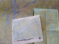
Step 3 - I label and print off collections of whichever smaller scales I feel I'd need. (The blue arrows shown below are mag lines to simplify things if I emit grid lines on maps smaller than 1:50,000)

maps.jpg


On a trip not too long ago we'd been on the water for no more than an hour on day 1 before I realized I'd brought the wrong small scale maps, the correct ones were in another Ziplock bag back in the parking lot.
No worries, the larger scale worked well with compass, it just lacked the finer detail. I also got to try out my Avenza Map app on my phone, just as a momentary gps check from time to time. Satellites eh?
But you can't beat maps and compass.

ps I posted on the wrong map thread originally. Sorry.
 
Last edited:
I was wondering, given the ability to design maps online, if folks use a different scale than 1:50,000 or 1:250,000? I've often thought 1:100,000 might be a good compromise for longish river trips...
 
I was wondering, given the ability to design maps online, if folks use a different scale than 1:50,000 or 1:250,000? I've often thought 1:100,000 might be a good compromise for longish river trips...


I generally stick with 1:50 almost all the time but I do create overview maps at a higher scale, for those I pick the size that will give me the most coverage with the fewest sheets of paper with no fixed scale. That results in some pages that might be 1:250, some that would be 1:200 some might be 1:150.

At the other end of the scale, when I need a detail map I might use 1:25 but again the main criteria is to get the complete area on one page.

I'm so used to estimating distance based on grid lines that I don't worry too much about the actual scale.

I print maps from Caltopo which allows printing at any scale you want.
 
Earlier in the post I mentioned custom printed maps from mytopo.com but I was disappointed when I visited their site a couple days ago to see they no longer offer that service. It looks like the maps are still semi-customizable but not nearly to the extent they were before. It's disappointing as I'm not sure anyone else was offering that.

They did give an 800 number to call if you needed to access custom maps stored in your old profile or to possibly have new ones created.

Alan
 
Is this the way to use mytopo to create custom maps? http://help.mytopo.com/knowledgebase/articles/1986634

I think you are correct. I hadn't seen that. I only skimmed through it but it sounds like maybe it's for the US only?
Too bad the software is so expensive to subscribe to but it's nice that they said they can renew your free trial anytime if you're sending maps in to be printed by them.

I might have to do that one of these days as I wanted a nice map of the area surrounding my house to hang on the wall. The ability to add markers, annotations, and maybe trails, will be nice for that.

Alan
 
I print the scanned topo green layer version with the contour lines. I add campsites, pictograph sites, portages, and magnetic north lines at strategic locations for compass use.
Our printer is an inkjet. Terrible. The waterproofing is necessary. So too is the clear Ziplock.

I have just revisited CalTopo and found that the CalTopo website has changed enough to require me to relearn marking, saving, and printing my own maps. It was never very user friendly and now seems less so.
 
Back
Top