We are thinking about a fly-in/paddle out trip from Red Lake for next summer. 2 paddlers, 1 canoe, 5 nights. Does anyone have some advice on a route, air service, parking, etc?
-
Happy Incorporation of Hudson's Bay Co. (1670) 🍁🦫🪓
You are using an out of date browser. It may not display this or other websites correctly.
You should upgrade or use an alternative browser.
You should upgrade or use an alternative browser.
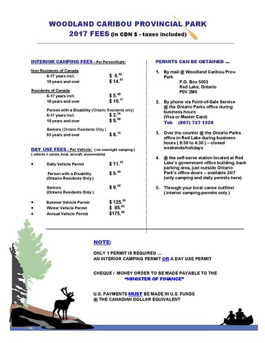
Woodland Caribou Provincial Park
- Thread starter Sweetfancymoses
- Start date
G
Guest
Guest
That sounds like the trip of a lifetime. Probably someone else’s lifetime; I am gawd awful Scot’s cheap when it comes to paying to paddle.
I expect the answer will be Harlan at Red Lake Outfitters:
https://www.redlakeoutfitters.com/
I expect the answer will be Harlan at Red Lake Outfitters:
https://www.redlakeoutfitters.com/
Saw this Youtube video by Joe Robinet I enjoyed which might be informative if you haven't already seen it: https://youtu.be/jd5AEjeE_CY
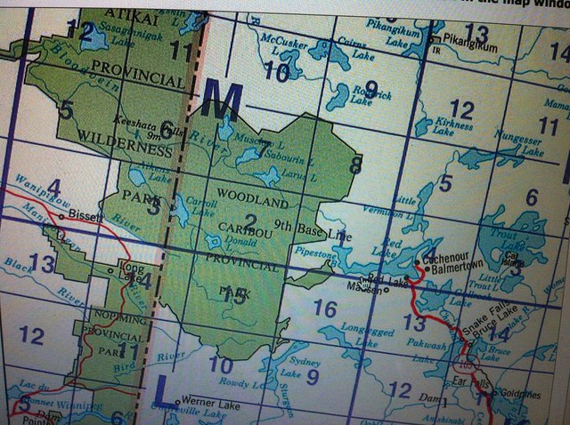
I've never been there, but I've studied the maps because I almost did a couple of times. I wouldn't pay for a plane either. If you have at least two vehicles, you can do a loop trip with no lake repeats by shuttling between two access points. Or Harlan can arrange a shuttle if you can't or don't want to do your own.
Well that nice two access point is not that easy. Access by car is limited.
I believe there is still a planning map. Portages usually in groups of three
Flying is expensive. Boat shuttles can be arranged. The MNR office in Red Lake can advise you
I'd go looking fore more time off work
I believe there is still a planning map. Portages usually in groups of three
Flying is expensive. Boat shuttles can be arranged. The MNR office in Red Lake can advise you
I'd go looking fore more time off work
I parked at Leano Lake access and did a 2-week trip from there, that is the southern part of the park. There are a lot of options right out of Leano for a 5-night trip if flying doesn't work out.
I've done a couple of 10 day solos out of Leano. No doubt Harlan can arrange for fly in but seems frightfully expensive for five days
Leano is probably the most popular put in. That said you probably won't see many people or any at all. I didn't
Leano is probably the most popular put in. That said you probably won't see many people or any at all. I didn't
Judging by Joe Robinets video it looks like great spot for fishing and wildlife viewing.
Lots of options. I would recvomend Goldseekers for an outfitter. They have a good relationship with the park people and have been doing the outfitting out of red lake for 20 years
Lots of options. I would recvomend Goldseekers for an outfitter. They have a good relationship with the park people and have been doing the outfitting out of red lake for 20 years
Last time I had real trouble connecting with them. They weren't responsive in I think 2009
Hope they are doing better now!
I got a lot of help from you re campsites.
Thank you for all the comments. Good advice as always. I wish we would have more time to spend but it's not in the cards. The first mate made the comment on our last trip to Quetico that it would be nice to see the lakes from a bird's perspective and I have to agree. Redlakeoutfitters make the comment on their website that the access points are very hard to reach by car. I was wondering, how far is the drive from the ranger station to Leano Lake and how are the roads?
Here is some info on Leano Lake http://www.woodlandcaribouprovincialpark.com/routes/leano-lake-options/
I drove to Leano Lake from rt 105 via 804, it was in good shape when I did the drive. I wonder if you can avoid driving up to Red Lake by buying permits on line. They say it's about an hour and 1/2 to two hours from Red Lake to Leano.
Claire Quewezence is the park manager and is a member here. (Quew), she said when I corresponded with her that she is more than happy to answer any questions from CT members.
I did buy some topo maps at a place on Rt 804 and iirc they sold park permits. This would save a few hours driving if you could avoid going to Red Lake.
Sweetfancymoses, glad to hear you're looking at at trip to WCPP....and incredible Boreal destination as others have attested to here. We'd be happy to help you out with anything you may require as far as routing, information, flights, shuttles etc..
Drop me an email at harlan@redlakeoutfitters.com and i'll get an information package out to you with some stuff that will aid in the planning process.
As far the road to Leano, conditions change on this road from time to time and although some passenger cars do make it all the way to Leano, i would advise against it. If you have access to a high clearance vehicle, you'll be alright. Just make sure you have tires with reinforced sidewalls as tire blowouts are the #1 issue we encounter on the road. Also of note, it's roughly 76 KM from our shop in Red Lake to Leano. The last 55KM of which is seldom traveled. We run shuttles virtually daily to Leano and hardly ever encounter another vehicle along the way. If you are bringing in a smaller vehicle, make sure you have the tools required for changing tires and to plan for what you would do if a break down occurred. It's a 2 day walk out should you not see anyone else on the road.
Happy to help with any other questions so fire away!
Also do not leave food or wrappers in the car.
Sometimes beaver dans flood the road. A small car may have issues
Sometimes beaver dans flood the road. A small car may have issues
Access road conditions for WCPP were recently updated here:
http://canoeing.com/forums/topic/backroad-conditions-august-2017-update/
http://canoeing.com/forums/topic/backroad-conditions-august-2017-update/
Access road conditions for WCPP were recently updated here:
http://canoeing.com/forums/topic/backroad-conditions-august-2017-update/
Good info.
I guess you can obtain a permit ahead of time without the detour through the ranger's office.
 https://flic.kr/p/Wu7BY4https://www.flickr.com/photos/133956285@N05/
Also, here is a link allowing you to download free topos. Use the format: 052K12 in the search window.
http://www.canmaps.com/topo/browse-topo-maps/052.html
 Indexhttps://www.flickr.com/photos/133956285@N05/
PS: Not looking forward to transcribing the campsite info from paddleplanner.com into the topo or Chrismar map.
Stopping at the Park Office is highly recommended. They do have the most up to date information and can advise on recent fires or areas to avoid. Also can give you locations of pictographs or fishing spots.
They also love to hear from paddlers after their trip as to conditions encountered or wildlife seen. All that information is compiled by Claire and her trusty staff of summer students. Ask to see her topo maps. They are a treasure trove of information.
It's also nice to see the cars in town with the canoes on their roof so the locals know that the park is a contributor to the economy. Some fail to see it, just a few really.
Road conditions do fluctuate usually after a heavy rain or some yahoo driving down there too fast creating washboard. There are many users of those roads from logging to exploration to trappers to MNR and hunters so please do keep that in mind when heading down the roads. As remote as they may seem if something did go wrong you wouldn't likely be out there long before somebody come along. Nobody from here would drive by somebody stuck out there. I once gave my truck keys to a complete stranger in the park to drive my truck out because a member of their party was not doing real well.
As far as route options go, look at a loop out of Onnie. It's a shorter drive and there are lots of areas to explore. Only drawback is you'll pass some fly in camps but mostly just freindly folks doing some fishing.
No matter what you decide there is an adventure awaiting you
PS: Not looking forward to transcribing the campsite info from paddleplanner.com into the topo or Chrismar map.
I've been through WCPP twice and never had campsite information. The search for a campsite is part of the fun. Sometimes when you wait too late into the evening you get stuck at a bad site because you didn't have time to find a good one but more often then not you stumble onto something good. The longer you're there the better your eyes and brain get at spotting potential site locations.
Alan
Similar threads
- Replies
- 5
- Views
- 451
- Replies
- 12
- Views
- 929
- Replies
- 63
- Views
- 5K
- Replies
- 26
- Views
- 2K
- Replies
- 8
- Views
- 1K