-
Happy National Sunglasses Day! ☀️🕶️😎
You are using an out of date browser. It may not display this or other websites correctly.
You should upgrade or use an alternative browser.
You should upgrade or use an alternative browser.
Woodland Caribou Provincial Park is Closed due to fires
- Thread starter Mihun09
- Start date
That park has had a rough few years
Yes, likely more burned areas than green.
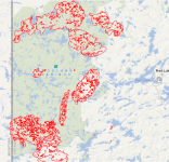
Very sad to see the whole park going up like this. No rain in sight either and these fires are even burning into each other. The map link is the best to really track the fire. Select layers in the upper right drop-down list. 0https://cwfis.cfs.nrcan.gc.ca/interactive-map?zoom=4¢er=122186.94437388869%2C368438.3202099733&month=7&day=27&year=218#wb-cont
More than half the park has burned now but the big fire, Kenora 51 hit a natural fire line from a burn a few years ago to the north and is mostly advancing south into crown land.
In the meantime, fires in Manitoba have burned the Bloodvein, Leyond, Barrens and Pigeon and are still active. https://www.gov.mb.ca/conservation_f.../fireview.html

In the meantime, fires in Manitoba have burned the Bloodvein, Leyond, Barrens and Pigeon and are still active. https://www.gov.mb.ca/conservation_f.../fireview.html
Just heartbreaking. How many years does it take for the fire dependent forest to recover? There ought to be lots of fireweed next year
What I worry about most in situations like this is that a park/area will be so damaged by fire that people will lose interest in it and that it will become abandoned/unprotected. It's hard to keep the long term in mind, especially when it's something that's not a quick fix.
In his book Sleeping Island, and his journals of other travels during that time, Downes lamented the loss of forest to heavy fires that were in the area at that time. When I traveled that same area a few years ago there were a handful of recently burned areas but most of it looked fine and many of the trees I cut for firewood were about 75 years old, which would indicate I was probably looking at forest that had possibly regenerated from those fires.
As bad as it might look now it will look great for someone else someday.
Alan
Christine and I, having canoed Atikaki for 10 years always looked at the amount of wood on the ground and how dry it has been since 2013 that eventually the entire province would burn and it would appear to be this year. Since 2013 the snow pack has melted weeks before ice out thus the area dried out early and we have not had rain in a couple months now although the northern areas are finally receiving rain although generally as thunderstorms. There are 154 fires burning in Manitoba today
Albert at Goldseekers Outfitting posted this info o
See All


Aaaand we're off and running again! -but with a few conditions.
For anyone still interested in paddling WCPP this year we’ve been given a small window of opportunity before the snow flies. I’ve proposed the 8 routes shown below to Parks and Fire management and all have been approved for use. These routes were designed to avoid travelling though this summer’s fires, although nearly all of them will at least skirt along the edge of current fire boundaries at some point during your trip. While the fires have not been declared out, there are no significant hotspots of concern at the moment. Do expect some helicopter activity as fire crews de-mobilize and fly patrols. Two way satellite communication devices will need to be carried as a precaution -we do have a limited number of devices available . Anyone entering the park MUST check in and out either with us, or with WCP Park staff. Online permits are not currently available so either obtain your permits at the park office, or at the self serve kiosk outside the park office should you arrive after business hours. I have a number of parties interested so if you have tentative dates, please let me know asap so that flights and shuttle can be arranged. Do remember this is autumn weather tripping so be prepared for temperatures ranging from below freezing to hot.
Approved Route Options:
1) Dunstan, Simeon, Larus, Murdock, Knox, exit at Lund -Fly-in/Shuttle Out
2) Donald, Black Otter, Sea Horse, Haggart River, Carroll (with a possible loop back to Donald for pick-up) -Fly-in Fly-out
3) Bulging, Haggart River, Carroll Lake. Fly-in Fly-out
4) Leano Lake to Kilbourn and return, -Shuttle in/out
5) Leano Lake -Bunny Loop -Shuttle in/out
6) Leano Lake, Bunny to Jake, eastern part of Paul, Elephant Head, Bunny, Leano. (W/option to head south to Upper Kilbourn, Kilbourn to Leano) Shuttle in/out
7) Barclay or Sabourin to Lund via the Bloodvein. -Fly-in/out
8 ) Aikens Lake MB to Donald. -Fly-in/out
A note from Ontario Parks.
Additional Considerations:
-You can expect to see increased air traffic in the park.
-Several fires remain active and fire suppression is ongoing – these fires are not out. Be aware you may see smoke from these fires.
-Entry into the park is at your own risk and you must ensure you have communication devices with you and a method of evacuation should it be needed.
-Please remember if you are planning a trip into the park which travels near a fire.
Fires will continue to smoke and grow pending weather
-SPOT – SOS is not an exit strategy, that is a last resort.
-Know where you are on a map so you understand your relationship towards the fires
-Communication is highly recommended to ensure contact if required (InReach device, satellite phone, SPOT unit etc)
-Situational awareness – watch the weather/winds/clouds/smoke direction
-Do not explore towards an active fire to “get a closer look”
-Ensure someone knows your route – WCPP office can be your contact if required, or your outfitter.
-Fires have the potential to move very fast pending weather
-Select a safe campsite – use the lake as a natural boundary between you and the fire.
-If camping\traveling through the burn - check trees as the roots maybe compromised posing a safety hazard.
We look forward to welcoming you back to WCPP!
Cheers,
A note from Albert at Goldseekers Outfidding about routes in Woodland Caribou P.P after the fires.
Photos
See All
Goldseekers Canoe Outfitting -Woodland Caribou Provincial Park
SeptetmobuerSps io3 atr 6:n4erd4f hPMd ·Aaaand we're off and running again! -but with a few conditions.
For anyone still interested in paddling WCPP this year we’ve been given a small window of opportunity before the snow flies. I’ve proposed the 8 routes shown below to Parks and Fire management and all have been approved for use. These routes were designed to avoid travelling though this summer’s fires, although nearly all of them will at least skirt along the edge of current fire boundaries at some point during your trip. While the fires have not been declared out, there are no significant hotspots of concern at the moment. Do expect some helicopter activity as fire crews de-mobilize and fly patrols. Two way satellite communication devices will need to be carried as a precaution -we do have a limited number of devices available . Anyone entering the park MUST check in and out either with us, or with WCP Park staff. Online permits are not currently available so either obtain your permits at the park office, or at the self serve kiosk outside the park office should you arrive after business hours. I have a number of parties interested so if you have tentative dates, please let me know asap so that flights and shuttle can be arranged. Do remember this is autumn weather tripping so be prepared for temperatures ranging from below freezing to hot.
Approved Route Options:
1) Dunstan, Simeon, Larus, Murdock, Knox, exit at Lund -Fly-in/Shuttle Out
2) Donald, Black Otter, Sea Horse, Haggart River, Carroll (with a possible loop back to Donald for pick-up) -Fly-in Fly-out
3) Bulging, Haggart River, Carroll Lake. Fly-in Fly-out
4) Leano Lake to Kilbourn and return, -Shuttle in/out
5) Leano Lake -Bunny Loop -Shuttle in/out
6) Leano Lake, Bunny to Jake, eastern part of Paul, Elephant Head, Bunny, Leano. (W/option to head south to Upper Kilbourn, Kilbourn to Leano) Shuttle in/out
7) Barclay or Sabourin to Lund via the Bloodvein. -Fly-in/out
8 ) Aikens Lake MB to Donald. -Fly-in/out
A note from Ontario Parks.
Additional Considerations:
-You can expect to see increased air traffic in the park.
-Several fires remain active and fire suppression is ongoing – these fires are not out. Be aware you may see smoke from these fires.
-Entry into the park is at your own risk and you must ensure you have communication devices with you and a method of evacuation should it be needed.
-Please remember if you are planning a trip into the park which travels near a fire.
Fires will continue to smoke and grow pending weather
-SPOT – SOS is not an exit strategy, that is a last resort.
-Know where you are on a map so you understand your relationship towards the fires
-Communication is highly recommended to ensure contact if required (InReach device, satellite phone, SPOT unit etc)
-Situational awareness – watch the weather/winds/clouds/smoke direction
-Do not explore towards an active fire to “get a closer look”
-Ensure someone knows your route – WCPP office can be your contact if required, or your outfitter.
-Fires have the potential to move very fast pending weather
-Select a safe campsite – use the lake as a natural boundary between you and the fire.
-If camping\traveling through the burn - check trees as the roots maybe compromised posing a safety hazard.
We look forward to welcoming you back to WCPP!
Cheers,
Last edited:
so sad. the three out and backs are really short.
Total area burned for 2021

Total area burned in Manitoba for the 2021 fire season...
3,129,713 acres or
4890 square miles
3,129,713 acres or
4890 square miles
An acre of mature trees can capture 2.6 tonnes of CO2 per year.
If we consider only half of the acres which burned to be mature trees that still equals 4,068, 626 tonnes of CO2 released back into the atmosphere.
However, the following article suggest the forests in Canada emit more carbon than they capture.
If we consider only half of the acres which burned to be mature trees that still equals 4,068, 626 tonnes of CO2 released back into the atmosphere.
However, the following article suggest the forests in Canada emit more carbon than they capture.
Total area burned in 1193 fires in Ontario, 5 still active
793,324 hectares
1,960,346 acres
3063.04 square miles
793,324 hectares
1,960,346 acres
3063.04 square miles
Similar threads
- Replies
- 10
- Views
- 2K