G
Guest
Guest
Using the Tortoise Reserve as my home base I arrived in Bladen County NC on Valentine’s Day, bearing a heart shaped box of chocolate (with a bite taken out of each piece) and a van full of tools and camping gear, intending to paddle the best of eastern NC and continue working off an “Incomplete” earned in a 1974 Field Biology class.
(More on the Reserve Days later)
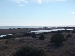
After a few days of rough carpentry and manual labor the forecast showed a mix of weather, including cold nights (27f) and short spell of rain. Perfect conditions to paddle into one of the more protected sites at Hammocks Beach State Park two hours east of the reserve.
I need a long spell of alone time, and Hammocks February should provide just that. I arrived as the Park opened with favorable tidal timing for the shallow approach to the paddle in sites, aiming for site 12 in a protected canopy of stunted live oak.
![URL]](http://[URL]http://i1285.photobucket.com/albums/a593/CooperMcCrea/North Carolina Winter 2013/P2180690_zps8d19c681.jpg[/URL])
![URL]](http://[URL]http://i1285.photobucket.com/albums/a593/CooperMcCrea/North Carolina Winter 2013/P2180703_zps8638ad9e.jpg[/URL])
Site 12 offers a superb hideaway from wind and weather, and with tent and tarp up and the canoe completely covered and spring lined down using the a small tree and the spiral dog run stake I’m ready for the nights forecast rain.
![URL]](http://[URL]http://i1285.photobucket.com/albums/a593/CooperMcCrea/North Carolina Winter 2013/P2190709_zps2d0f336c.jpg[/URL])
![URL]](http://[URL]http://i1285.photobucket.com/albums/a593/CooperMcCrea/North Carolina Winter 2013/P2180692_zpsb5adc904.jpg[/URL])
I want to figure out the tidal flux between Bogue Inlet and the campsite channel, so I pull out the watch I use almost solely for tidal timing and find the battery dead. Turning to the dreaded cell phone I found that it displays the time. Whodathunk it.
I staked the rising and falling tide over the next few days and was able to discern that low tide, in the narrow neck between the Bouge Inlet marsh and the inner-island tidal lake, falls 2 hours after Bogue Inlet, as it takes a long time for the lake to drain, but high tide is almost right on the inlet, as the inrushing water piles up in the narrows.
Low tide in the inlet is very low.
![URL]](http://[URL]http://i1285.photobucket.com/albums/a593/CooperMcCrea/North Carolina Winter 2013/P2180705_zps1cdbaa62.jpg[/URL])
Time to set up the wind chair for maximum protection and don my winter apparel.
![URL]](http://[URL]http://i1285.photobucket.com/albums/a593/CooperMcCrea/North Carolina Winter 2013/P2190707_zpsd0f57485.jpg[/URL])
![URL]](http://[URL]http://i1285.photobucket.com/albums/a593/CooperMcCrea/North Carolina Winter 2013/P2180699_zps2dc99fdc.jpg[/URL])
It is brisk out, and a personal warming fire would be a comfort. The fire-in-a-can is ideal; I can light it for a bit of warmth and, once warmed, put it out with the cover and wander again into the chill of the high dunes behind camp, turning it on and off like a personal heater.
![URL]](http://[URL]http://i1285.photobucket.com/albums/a593/CooperMcCrea/North Carolina Winter 2013/P2190712_zps3123b400.jpg[/URL])
![URL]](http://[URL]http://i1285.photobucket.com/albums/a593/CooperMcCrea/North Carolina Winter 2013/P2190713_zps85991cfa.jpg[/URL])
![URL]](http://[URL]http://i1285.photobucket.com/albums/a593/CooperMcCrea/North Carolina Winter 2013/P2190715_zpsac1d252f.jpg[/URL])
Not a bad first day, and there lots of exploring to do. Given the forecast I doubt I’ll see another soul; rain and thunderstorms tonight with high winds, with SW winds tomorrow 15-20, highs in the 50’s, lows in the lower 30’s.
The aural background is a mix. Mostly the surf, with a base note of artillery exploding in the distance, and when the wind is right the low moan of the Bogue Inlet horn. The Marine aviation seems less that in October of last year; just a few distant helicopters and one flyover of 10 tilt-rotor Osprey in 3/7 formation. Awesome.
There followed several days of wandering the high dunes
![URL]](http://[URL]http://i1285.photobucket.com/albums/a593/CooperMcCrea/North Carolina Winter 2013/P2200728_zpsa5bfd6fa.jpg[/URL])
Checking out the other protected campsites. #14 is well wind protected, level and large, with a good landing before the worst of the inlet shallows
![URL]](http://[URL]http://i1285.photobucket.com/albums/a593/CooperMcCrea/North Carolina Winter 2013/P2200724_zps918c3e7c.jpg[/URL])
And falling down rabbit holes
![URL]](http://[URL]http://i1285.photobucket.com/albums/a593/CooperMcCrea/North Carolina Winter 2013/P2200726_zpsf58d990a.jpg[/URL])
Until, several days into my stay I looked down the channel to see a lone kayaker slowing paddling and towing his way in my direction. Whereupon I soon met Legally Blind Dave, a visually impaired Swansboro kayaker who paddles into Bear Island largely on instinct and feel.
I do not mention that I made a wrong turn, even with a marked trail to follow.
![URL]](http://[URL]http://i1285.photobucket.com/albums/a593/CooperMcCrea/North Carolina Winter 2013/P2200721_zps0b873535.jpg[/URL])
Legally Blind Dave filled me in one some local history that isn’t in my guidebooks, including the location of Fort Huggins on the south side of Huggins Island (attacked twice by the Union Navy and taken, burned demolished by explosive. This area has a long history of explosions.
Dave also told of the remains of Congressman Dare’s Bear Island home, nestled in the high and forested dunes above site 14. I looked, I did not find, but the view from that highest point on the island is spectacular.
I cannot get to know and appreciate an area while passing through on foot or in a boat. I need to sit amongst the trees and shrubs and look, listen and think for a few days. Hammocks Beach gave me that opportunity.
(More on the Reserve Days later)
After a few days of rough carpentry and manual labor the forecast showed a mix of weather, including cold nights (27f) and short spell of rain. Perfect conditions to paddle into one of the more protected sites at Hammocks Beach State Park two hours east of the reserve.
I need a long spell of alone time, and Hammocks February should provide just that. I arrived as the Park opened with favorable tidal timing for the shallow approach to the paddle in sites, aiming for site 12 in a protected canopy of stunted live oak.
Site 12 offers a superb hideaway from wind and weather, and with tent and tarp up and the canoe completely covered and spring lined down using the a small tree and the spiral dog run stake I’m ready for the nights forecast rain.
I want to figure out the tidal flux between Bogue Inlet and the campsite channel, so I pull out the watch I use almost solely for tidal timing and find the battery dead. Turning to the dreaded cell phone I found that it displays the time. Whodathunk it.
I staked the rising and falling tide over the next few days and was able to discern that low tide, in the narrow neck between the Bouge Inlet marsh and the inner-island tidal lake, falls 2 hours after Bogue Inlet, as it takes a long time for the lake to drain, but high tide is almost right on the inlet, as the inrushing water piles up in the narrows.
Low tide in the inlet is very low.
Time to set up the wind chair for maximum protection and don my winter apparel.
It is brisk out, and a personal warming fire would be a comfort. The fire-in-a-can is ideal; I can light it for a bit of warmth and, once warmed, put it out with the cover and wander again into the chill of the high dunes behind camp, turning it on and off like a personal heater.
Not a bad first day, and there lots of exploring to do. Given the forecast I doubt I’ll see another soul; rain and thunderstorms tonight with high winds, with SW winds tomorrow 15-20, highs in the 50’s, lows in the lower 30’s.
The aural background is a mix. Mostly the surf, with a base note of artillery exploding in the distance, and when the wind is right the low moan of the Bogue Inlet horn. The Marine aviation seems less that in October of last year; just a few distant helicopters and one flyover of 10 tilt-rotor Osprey in 3/7 formation. Awesome.
There followed several days of wandering the high dunes
Checking out the other protected campsites. #14 is well wind protected, level and large, with a good landing before the worst of the inlet shallows
And falling down rabbit holes
Until, several days into my stay I looked down the channel to see a lone kayaker slowing paddling and towing his way in my direction. Whereupon I soon met Legally Blind Dave, a visually impaired Swansboro kayaker who paddles into Bear Island largely on instinct and feel.
I do not mention that I made a wrong turn, even with a marked trail to follow.
Legally Blind Dave filled me in one some local history that isn’t in my guidebooks, including the location of Fort Huggins on the south side of Huggins Island (attacked twice by the Union Navy and taken, burned demolished by explosive. This area has a long history of explosions.
Dave also told of the remains of Congressman Dare’s Bear Island home, nestled in the high and forested dunes above site 14. I looked, I did not find, but the view from that highest point on the island is spectacular.
I cannot get to know and appreciate an area while passing through on foot or in a boat. I need to sit amongst the trees and shrubs and look, listen and think for a few days. Hammocks Beach gave me that opportunity.
![URL]](http://[URL]http://i1285.photobucket.com/albums/a593/CooperMcCrea/North Carolina Winter 2013/P3060788_zpsbbaf8d0d.jpg[/URL])
![URL]](http://[URL]http://i1285.photobucket.com/albums/a593/CooperMcCrea/North Carolina Winter 2013/P2280757_zpsac79a8b1.jpg[/URL])
![URL]](http://[URL]http://i1285.photobucket.com/albums/a593/CooperMcCrea/North Carolina Winter 2013/P2270744_zps0f779d69.jpg[/URL])
![URL]](http://[URL]http://i1285.photobucket.com/albums/a593/CooperMcCrea/North Carolina Winter 2013/P2280755_zps20aba048.jpg[/URL])
![URL]](http://[URL]http://i1285.photobucket.com/albums/a593/CooperMcCrea/North Carolina Winter 2013/P2280768-Copy_zps8a27a0bd.jpg[/URL])
![URL]](http://[URL]http://i1285.photobucket.com/albums/a593/CooperMcCrea/North Carolina Winter 2013/P2260742_zpse2737938.jpg[/URL])
![URL]](http://[URL]http://i1285.photobucket.com/albums/a593/CooperMcCrea/North Carolina Winter 2013/P2280754_zps49dd1e1e.jpg[/URL])
![URL]](http://[URL]http://i1285.photobucket.com/albums/a593/CooperMcCrea/North Carolina Winter 2013/P2280756_zps93907656.jpg[/URL])
![URL]](http://[URL]http://i1285.photobucket.com/albums/a593/CooperMcCrea/North Carolina Winter 2013/P2280763_zpseb724ae0.jpg[/URL])
![URL]](http://[URL]http://i1285.photobucket.com/albums/a593/CooperMcCrea/North Carolina Winter 2013/P2280759_zpsed914b44.jpg[/URL])
![URL]](http://[URL]http://i1285.photobucket.com/albums/a593/CooperMcCrea/North Carolina Winter 2013/P2280762_zps8135e4c5.jpg[/URL])
![URL]](http://[URL]http://i1285.photobucket.com/albums/a593/CooperMcCrea/North Carolina Winter 2013/P2280765_zps819b3a7f.jpg[/URL])
![URL]](http://[URL]http://i1285.photobucket.com/albums/a593/CooperMcCrea/North Carolina Winter 2013/P3040782_zps7ca63598.jpg[/URL])
![URL]](http://[URL]http://i1285.photobucket.com/albums/a593/CooperMcCrea/North Carolina Winter 2013/P3050785_zpsc11eda77.jpg[/URL])
![URL]](http://[URL]http://i1285.photobucket.com/albums/a593/CooperMcCrea/North Carolina Winter 2013/P3040783_zps0d2b3d6e.jpg[/URL])
![URL]](http://[URL]http://i1285.photobucket.com/albums/a593/CooperMcCrea/North Carolina Winter 2013/P3080828_zpsaba8c989.jpg[/URL])
![URL]](http://[URL]http://i1285.photobucket.com/albums/a593/CooperMcCrea/North Carolina Winter 2013/P3070805_zpsc659d308.jpg[/URL])
![URL]](http://[URL]http://i1285.photobucket.com/albums/a593/CooperMcCrea/North Carolina Winter 2013/P3070804_zps01f59e26.jpg[/URL])
![URL]](http://[URL]http://i1285.photobucket.com/albums/a593/CooperMcCrea/North Carolina Winter 2013/P3070814_zpsc5a88763.jpg[/URL])
![URL]](http://[URL]http://i1285.photobucket.com/albums/a593/CooperMcCrea/North Carolina Winter 2013/P3070819_zpsfabc361c.jpg[/URL])
![URL]](http://[URL]http://i1285.photobucket.com/albums/a593/CooperMcCrea/North Carolina Winter 2013/P3070822_zps7c62ff1c.jpg[/URL])
![URL]](http://[URL]http://i1285.photobucket.com/albums/a593/CooperMcCrea/North Carolina Winter 2013/P3080826_zpsec5a4750.jpg[/URL])
![URL]](http://[URL]http://i1285.photobucket.com/albums/a593/CooperMcCrea/North Carolina Winter 2013/P3080835_zps078c01f6.jpg[/URL])
![URL]](http://[URL]http://i1285.photobucket.com/albums/a593/CooperMcCrea/North Carolina Winter 2013/P3080834_zpsc340fd70.jpg[/URL])
![URL]](http://[URL]http://i1285.photobucket.com/albums/a593/CooperMcCrea/North Carolina Winter 2013/P3080839_zpsd2dae647.jpg[/URL])
![URL]](http://[URL]http://i1285.photobucket.com/albums/a593/CooperMcCrea/North Carolina Winter 2013/P3080837_zpsab39a98e.jpg[/URL])
![URL]](http://[URL]http://i1285.photobucket.com/albums/a593/CooperMcCrea/North Carolina Winter 2013/P3080840_zps4401abe1.jpg[/URL])