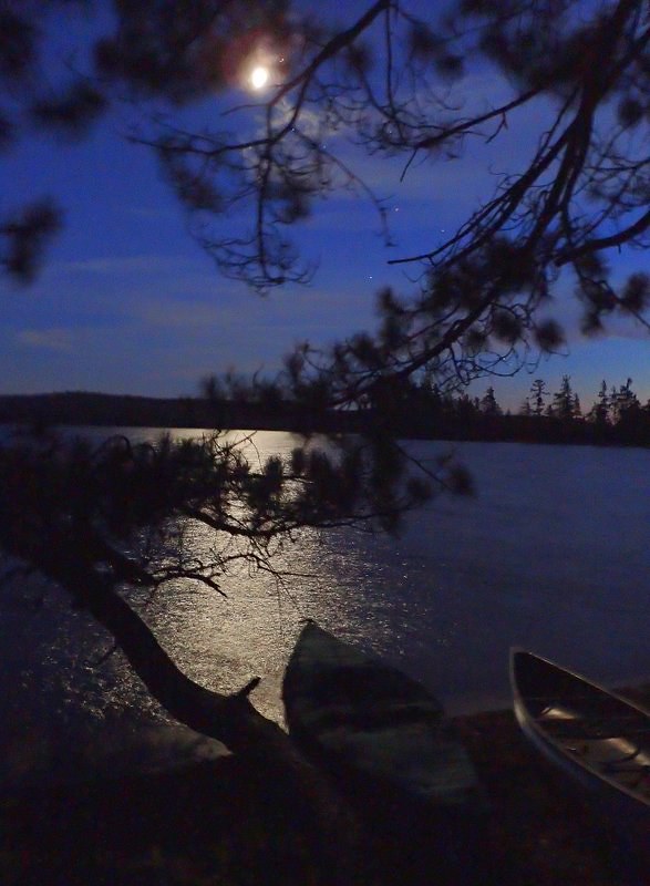
Last month I made two solo trips to Little Tupper Lake. The first was on the weekend of May 14-16; the second trip was May 28-31 (Memorial Day Weekend). This report will cover the second trip (with some photos from the first trip).

Introduction/Background
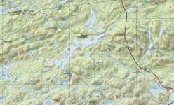
Little Tupper Lake is a major body of water in the William C. Whitney Wilderness Area, which is located in the central Adirondacks, between towns of Long Lake and Tupper Lake. Little Tupper is connected to several other water bodies in the wilderness area, including Round Lake (which you can paddle to directly from Little Tupper without a carry) and Rock Pond, which has a very short carry and some lifts over beaver dams. Both of these bodies are worth a visit either as part of a trip to Little Tupper or as separate trip destinations.
Day 1: Friday, May 28
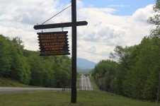
I had a late departure from home due to no preparations being done in the immediate days before the trip because I was just too busy. I had to shop for food on Thursday as well, so I didn't leave home until nearly 7:00 AM on Friday. I arrived at the turn-off for Little Tupper Lake around 11:15 and the put-in a short time later.
Granted it was Friday, but it was Memorial Day Weekend so I was surprised to find only six cars in the parking lot. Shortly after my arrival, I met and chatted with the assistant forest ranger for the area. I also met two paddlers from Rochester who were coming out from an 8-day stay on Rock Pond. Although I was anxious to get on the water, I thoroughly enjoyed meeting all three and having those conversations. Little Tupper is a pretty big lake, is often windy and has waves, so I chose to take the Sawyer, rather than the Hornbeck for this trip. So it was about 12:15 by the time I had the canoe and all the gear down at the sandy, beach put-in and ready to go.
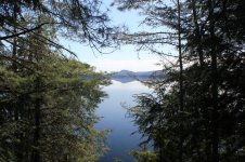
Although it always looks calm from the put-in, after rounding the first point and getting out into the main lake, I was pleasantly surprised to find that it was still relatively calm. After about a half hour of paddling,I arrived at site #6, whose landing is on a rocky point.


I had wanted to check out this site on the last trip, so I took this opportunity to have a look. I pulled the canoe partially up on the rocks at the landing and took the path up to the site, which is on a rise with a view back down the lake. The site has plenty of space for tents, but importantly (for me), it also had plenty of trees for me to hang my hammock.
After this brief stop, I launched to continue my paddle up the lake. I paddled along, relatively close to shore, to minimize the effect of the wind, although unusually, the wind was actually behind me. It showered lightly from time to time, more a mist than actual rain. I passed site #10, which was empty. On my last trip, I stopped to check out this site. It has a nice beach landing and much like site #6, the site is up on a rise above the lake with plenty of room for tents, trees for hammocks, a thunderbox and good fire ring.


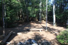
I continued on and shortly arrived at site #11 which was occupied, with two canoes on-shore. I had stayed at this site on my trip earlier in the month and really enjoyed it. Even though I tend to camp at different sites each time I visit an area, had it been available, I probably would have camped there again.
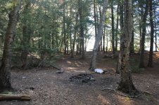
There is a small, sandy/rocky beach where one can easily land to load/unload the canoe. There is enough room to pull a couple of canoes up on shore while camped there. The site sits up on a rise above the lake, is pretty open, giving one a great view up and down the lake. There is a wet area behind the site that is rich in bird and plant life. There is plenty of room for tents and trees for hammocks. It has what is perhaps the best fire ring of all the sites (and on my visit, a huge store of fire wood ready for use). To get to the thunderbox, one takes the path that runs off to the one side of the site, down a small embankment to its location on the edge of the wet area. Here are some photos from my stay there on the previous trip.
While looking longingly at site #11, I recalled how great it was to camp there, with more than enough room for my hammock and the bug shelter.
Unfortunately, this site was also occupied, so I would have to continue on and cross over to the eastern side of the lake, my intended destination being site #14, which is located on a large island near the head of the lake, just east of the Rock Pond outlet. It was showering as I arrived around 3:30, and the site was not taken and looked good, so I decided this was going to be home for the weekend. The landing area is not ideal, it is small and rocky, making the unloading/loading somewhat difficult, but certainly manageable. I stowed the canoe and the paddles in the landing area. It took three trips to get all the gear up to the camping area.
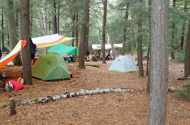
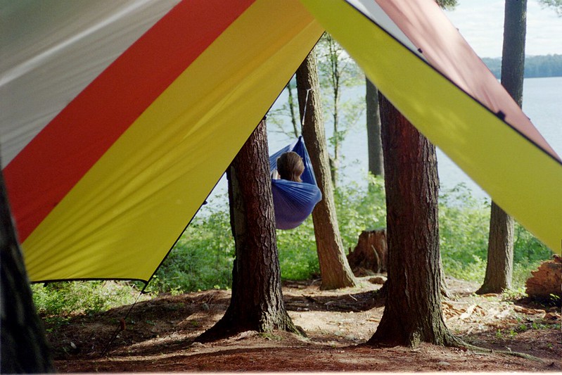
The actual camping area is at the top of a hill, in an area with many large white pines, suitable for hammocks and with several flat, open areas for tents. There is a good fire ring and the sign for the thunderbox, a short walk, back in the woods. I set-up the Warbonnet Ridgerunner hammock in porch mode, providing an overlook of the lake. My sleep system (top quilt, under quilt and under quilt protector) were packed as separate items (rather than in the hammock catch-all), so it took a bit more time to set everything up. I brought along the military casualty blanket, which I slid into the hammock sleeve and a wool blanket, which I put inside the hammock as another layer. Later, when I noticed the temperature dropping, I decided to put on the sock, as it was supposed to go down into the lower 30s.
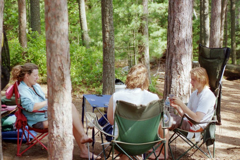
I pitched the Nemo Bug-Out shelter more towards the center of the site, closer to the fire ring. In addition to the table and chair, I decided to string up the Hidden Wild double travel hammock I had purchased at Costco to try out. With all the gear stowed in the shelter, I decided it was time for a late lunch, so I pulled out the deli (eggplant and roasted peppers) sandwich I had purchased on the way out of town, along with a cup of tea. The remainder of the day was spent finishing camp setup and chores, including collecting some firewood. When all this was done, it being a long day, I decided to turn in; it was around 9 PM. Pretty much as soon as I hit the hammock, I was asleep.
I woke up around 1 AM and checked the temperature on the outside thermometer - 34 degrees. The thermometer inside the sock read 52 degrees. My base layer of merino wool long underwear, along with a down sweater and beanie. I next woke at 7:30 AM when nature called and then re-entered the hammock, promptly fell asleep, next waking and getting up around 10 AM.
Day 2: Saturday, May 29
The weather report was good - blue, sunny skies, scattered clouds and temperatures in mid to upper 60's. There was supposed to be little wind. The plan is to take a paddle around the area of the lake where I am camped. After getting up and dressing, I prepared a quick breakfast of instant oatmeal, a breakfast biscuit, a clementine and coffee.
After breakfast, I walked the area around the campsite, taking photos and finding a good spot for photos of the sunset. After returning to the campsite, I checked the thermometer and it read 57 degrees - lower than the forecast; it felt colder than that, probably because of the wind, which had grown steady, moving the branches of the trees along the lake shore. I noted that all the trees and bushes were now green, a stark contrast to what it was like when I came to the area just two weeks before. Spring had really sprung! So far the bugs have not been bad at all. I have seen some black flies and mosquitos, but they have not been bothersome. I am quite certain that the fairly constant breezes and the cool temperatures have helped keep them at bay.
I went down to the lake shore to prepare the canoe for my planned excursion, but upon arriving, I noted that it was much windier than it was at the campsite in the trees. The lake had many white caps, which would make my planned paddle of the shoreline and taking pictures difficult, if not impossible. That being the case, I changed my plan and decided to spend the day on the island, exploring and taking photos.
After taking photos, some video and making some field (sound recordings), I returned to the campsite for a late lunch of tuna on a pita with tomato and some tea. I spent the remainder of the afternoon reading and relaxing around camp until dinner (chicken patty with stewed tomatoes and a Knorr rice side dish. After dinner and clean-up, I took my cup of tea and dessert (an Rx Bar) over to an area of the island that faced west to watch the sunset. And what a sunset it was!
After the sunset, I returned to the campsite and readied it for the night, stowing gear in the dry bags, securing them and my food supplies. It was about 9:15 when I changed and climbed into the hammock. I read until I was struggling to keep my eyes open, falling asleep to the sound of owls and loons calling from distant parts of the lake.
Day 3: Sunday, May 30
I woke up around 7:30 to mostly gray skies and no wind. Looking to the south, I could see some blue skies, so despite what it was at them moment and the forecast of showers during the day and a possibility of some rain, I was hopeful for some more good weather. Breakfast was scrambled eggs and turkey bacon in a pita, of course with coffee. After breakfast, I decided to process the firewood I had collected so it was ready for an evening campfire. When the firewood processing was done, it was still gray and overcast, but it was not showering or raining, so I decided to take a day paddle and visit the other campsites in the area, with the purpose of marking them as waypoints on my GPS unit. After packing up my photo and video gear, I launched, heading towards the first of the campsites, #15, which is on another part of the island where my campsite was located.
Campsite #15 looked abandoned except for the campsite marker and number on the tree. There was a huge log blocking the landing area of the site. I was able to land in a brushy, rocky area to the side of the landing area. The immediate area behind the landing point was overgrown and there was a lot of blowdown. A campsite marker with an arrow was on one of the still-standing trees, pointing uphill. However, with the amount of blowdown in the area, there was no obvious trail to the campsite. Also, there was no visible marker further up the hill to indicate where the campsite was located. I decided against bushwhacking up hill to try to locate the campsite.
My next destination was campsite #17, as I wanted to check it out. I had visited it on a previous trip, but I wanted to see it again. However, upon launching, I noticed another solo paddler heading towards it. I slowly paddled in the direction of the campsite, but part way there, decided against continuing, as the paddler had landed and was spending time checking out the site. Assuming he was another camper, because of the amount of time he was spending there, I thought he was going to occupy the campsite, so I decided to continue on to campsite #16. I soon arrived there and was marking the waypoint when I noticed the paddler I had seen earlier paddling towards me.
When he arrived, we greeted each other and introduced ourselves. It turns out he was the Backcountry Steward for the William C. Whitney Wilderness Area. We spoke briefly and I informed him about what I found at site #15. He told me he was meeting up with the Assistant Forest Ranger, who was paddling up the far shore of the lake. He disembarked from his canoe to check out site #16. I went on towards site #17, pulled up and marked the waypoint on my GPS unit.
From there, I headed towards site #18, which I was very curious about, it being an island site that I had seen on a previous trip to Little Tupper. Although it is a small site, it turned out to be very nice and one that I definitely come back to. My visit to site #18 was a quick one, as both the rain and the wind had picked up, so it was time to make my way back to my campsite.
Upon my return to the campsite, I started a fire, changed out of my now slightly damp clothing and got around to having lunch. While having lunch, the showers turned to a steady, light rain. I spent the remainder of the afternoon relaxing under the bug shelter/tarp, drinking tea and doing some reading. Occasionally I would venture over to the fire ring to add some wood and spent some time there warming up. Later I took a walk around camp to stretch my legs.
The remainder of the afternoon was spent reading and relaxing under the bug shelter, as the rain continued on and off. Dinner was simple, a Knorr rice side dish resulting in little clean-up. Keeping dinner and clean-up simple provided time to prepare gear for departure tomorrow, while still allowing time to sit before the campfire enjoying some quiet time as darkness came over the campsite. Once it became almost completely dark, I went down by and spent some time just taking in the night sounds.
Day 4: Monday, May 31
I awoke early (5:30) to an overcast, gray day. There was some wind and the temperatures were in the mid-40s as I sat under the bug shelter and had a quick breakfast of grape nuts and coffee.
Once breakfast was done and the cook kit was packed away, I turned to finishing up the packing of the gear, beginning with the hammock set-up, which went fairly quickly. Once the tarp was down, knowing that I was going to remove the sock from the hammock when I returned home, I decided to just remove the spreader bars from the hammock, rather than removing the quilts, I just stuffed the sock, with the hammock and quilts still inside it, into the bottom of the large dry bag. Once home, I would remove the sock and put the hammock (with the quilts and pillow) into the catch-all, ready for the next trip.
When the packing of the hammock was done, I turned to the bug shelter. I removed all of the gear from under it, placing it by the logs near the fire ring along with the hammock gear. I then collapsed the bug shelter and packed it away.
Next began the process of moving all the gear down to canoe for loading. I pulled the canoe from its resting place, turned it over and placed it partially in the water. I removed the spray cover from its stuff sack, spread it out over the canoe and snapped it place down the far side of the canoe, leaving the near side available for loading. Before going back up the hill for another load of gear, I used the Granite Gear sink that I bring along to scoop up some water to drown out the fire. I would repeat this a couple of times to be sure the fire (or embers) were all extinguished.
It took three trips to get all the gear down to the canoe. Next was loading the canoe, beginning with the large dry bag which goes behind the seat, taking up most of the space. One of the smaller dry bags, along with axe/saw sling and spare paddle, also get stowed in this area. The front of the canoe holds the thwart bag, the dry bag with the camera/video/sound gear and the food bag. Once all the gear was in the canoe, I pulled the spray cover over the canoe and snapped it into place.
It was still overcast as I launched for the paddle back to the put-in site. The lake was calm near my campsite. I would not see what the rest of the lake is like until I get out beyond the island I was camped on into the open lake. As I headed out towards the main part of the lake, the wind and the waves gradually picked up.
After crossing the first stretch of open water, I approached the first of the islands I would pass by on the paddle out. I took shelter behind it to get out of the wind and enjoy a few sips of coffee. A short time later, I rounded the point of the island went back out into the wind and the small waves it created.
Leaving the shelter of the island, I decided to set a course for the eastern shoreline. With the wind and waves, it seems more prudent to travel close to shore. It would not add a significant amount of distance to the trip, but would make it easier to get off the water should the conditions worsen.
Paddling along the shoreline provided me with opportunities to observe the trees and other vegetation close-up. However, it was too windy and wavy for me to take photos. It didn't take that long to run out of shoreline and have a fairly large bay to cross. I headed towards the distant shoreline in more or less a straight-line course across the bay. In another 45 minutes, I would be pulling up to the take-out, unloading the canoe, carrying the gear to the car and loading up for the ride home, having had a wonderful four days in the Adirondack wilderness.
Introduction/Background
Little Tupper Lake is a major body of water in the William C. Whitney Wilderness Area, which is located in the central Adirondacks, between towns of Long Lake and Tupper Lake. Little Tupper is connected to several other water bodies in the wilderness area, including Round Lake (which you can paddle to directly from Little Tupper without a carry) and Rock Pond, which has a very short carry and some lifts over beaver dams. Both of these bodies are worth a visit either as part of a trip to Little Tupper or as separate trip destinations.
Day 1: Friday, May 28
I had a late departure from home due to no preparations being done in the immediate days before the trip because I was just too busy. I had to shop for food on Thursday as well, so I didn't leave home until nearly 7:00 AM on Friday. I arrived at the turn-off for Little Tupper Lake around 11:15 and the put-in a short time later.
Granted it was Friday, but it was Memorial Day Weekend so I was surprised to find only six cars in the parking lot. Shortly after my arrival, I met and chatted with the assistant forest ranger for the area. I also met two paddlers from Rochester who were coming out from an 8-day stay on Rock Pond. Although I was anxious to get on the water, I thoroughly enjoyed meeting all three and having those conversations. Little Tupper is a pretty big lake, is often windy and has waves, so I chose to take the Sawyer, rather than the Hornbeck for this trip. So it was about 12:15 by the time I had the canoe and all the gear down at the sandy, beach put-in and ready to go.
Although it always looks calm from the put-in, after rounding the first point and getting out into the main lake, I was pleasantly surprised to find that it was still relatively calm. After about a half hour of paddling,I arrived at site #6, whose landing is on a rocky point.
I had wanted to check out this site on the last trip, so I took this opportunity to have a look. I pulled the canoe partially up on the rocks at the landing and took the path up to the site, which is on a rise with a view back down the lake. The site has plenty of space for tents, but importantly (for me), it also had plenty of trees for me to hang my hammock.
After this brief stop, I launched to continue my paddle up the lake. I paddled along, relatively close to shore, to minimize the effect of the wind, although unusually, the wind was actually behind me. It showered lightly from time to time, more a mist than actual rain. I passed site #10, which was empty. On my last trip, I stopped to check out this site. It has a nice beach landing and much like site #6, the site is up on a rise above the lake with plenty of room for tents, trees for hammocks, a thunderbox and good fire ring.
I continued on and shortly arrived at site #11 which was occupied, with two canoes on-shore. I had stayed at this site on my trip earlier in the month and really enjoyed it. Even though I tend to camp at different sites each time I visit an area, had it been available, I probably would have camped there again.
There is a small, sandy/rocky beach where one can easily land to load/unload the canoe. There is enough room to pull a couple of canoes up on shore while camped there. The site sits up on a rise above the lake, is pretty open, giving one a great view up and down the lake. There is a wet area behind the site that is rich in bird and plant life. There is plenty of room for tents and trees for hammocks. It has what is perhaps the best fire ring of all the sites (and on my visit, a huge store of fire wood ready for use). To get to the thunderbox, one takes the path that runs off to the one side of the site, down a small embankment to its location on the edge of the wet area. Here are some photos from my stay there on the previous trip.
While looking longingly at site #11, I recalled how great it was to camp there, with more than enough room for my hammock and the bug shelter.
I continued up the lake towards site #12, one of my intended destinations (and possible campsite) for this trip. Like the other sites visited thus far, it too sits on a rise, high above the lake. The landing is not ideal, making it a somewhat difficult spot to load/unload a canoe, but the site itself, with ample room for tents and good trees for hammocks, together with the fine view is well worth this slight inconvenience.
Unfortunately, this site was also occupied, so I would have to continue on and cross over to the eastern side of the lake, my intended destination being site #14, which is located on a large island near the head of the lake, just east of the Rock Pond outlet. It was showering as I arrived around 3:30, and the site was not taken and looked good, so I decided this was going to be home for the weekend. The landing area is not ideal, it is small and rocky, making the unloading/loading somewhat difficult, but certainly manageable. I stowed the canoe and the paddles in the landing area. It took three trips to get all the gear up to the camping area.
The actual camping area is at the top of a hill, in an area with many large white pines, suitable for hammocks and with several flat, open areas for tents. There is a good fire ring and the sign for the thunderbox, a short walk, back in the woods. I set-up the Warbonnet Ridgerunner hammock in porch mode, providing an overlook of the lake. My sleep system (top quilt, under quilt and under quilt protector) were packed as separate items (rather than in the hammock catch-all), so it took a bit more time to set everything up. I brought along the military casualty blanket, which I slid into the hammock sleeve and a wool blanket, which I put inside the hammock as another layer. Later, when I noticed the temperature dropping, I decided to put on the sock, as it was supposed to go down into the lower 30s.
I pitched the Nemo Bug-Out shelter more towards the center of the site, closer to the fire ring. In addition to the table and chair, I decided to string up the Hidden Wild double travel hammock I had purchased at Costco to try out. With all the gear stowed in the shelter, I decided it was time for a late lunch, so I pulled out the deli (eggplant and roasted peppers) sandwich I had purchased on the way out of town, along with a cup of tea. The remainder of the day was spent finishing camp setup and chores, including collecting some firewood. When all this was done, it being a long day, I decided to turn in; it was around 9 PM. Pretty much as soon as I hit the hammock, I was asleep.
I woke up around 1 AM and checked the temperature on the outside thermometer - 34 degrees. The thermometer inside the sock read 52 degrees. My base layer of merino wool long underwear, along with a down sweater and beanie. I next woke at 7:30 AM when nature called and then re-entered the hammock, promptly fell asleep, next waking and getting up around 10 AM.
Day 2: Saturday, May 29
The weather report was good - blue, sunny skies, scattered clouds and temperatures in mid to upper 60's. There was supposed to be little wind. The plan is to take a paddle around the area of the lake where I am camped. After getting up and dressing, I prepared a quick breakfast of instant oatmeal, a breakfast biscuit, a clementine and coffee.
After breakfast, I walked the area around the campsite, taking photos and finding a good spot for photos of the sunset. After returning to the campsite, I checked the thermometer and it read 57 degrees - lower than the forecast; it felt colder than that, probably because of the wind, which had grown steady, moving the branches of the trees along the lake shore. I noted that all the trees and bushes were now green, a stark contrast to what it was like when I came to the area just two weeks before. Spring had really sprung! So far the bugs have not been bad at all. I have seen some black flies and mosquitos, but they have not been bothersome. I am quite certain that the fairly constant breezes and the cool temperatures have helped keep them at bay.
I went down to the lake shore to prepare the canoe for my planned excursion, but upon arriving, I noted that it was much windier than it was at the campsite in the trees. The lake had many white caps, which would make my planned paddle of the shoreline and taking pictures difficult, if not impossible. That being the case, I changed my plan and decided to spend the day on the island, exploring and taking photos.
After taking photos, some video and making some field (sound recordings), I returned to the campsite for a late lunch of tuna on a pita with tomato and some tea. I spent the remainder of the afternoon reading and relaxing around camp until dinner (chicken patty with stewed tomatoes and a Knorr rice side dish. After dinner and clean-up, I took my cup of tea and dessert (an Rx Bar) over to an area of the island that faced west to watch the sunset. And what a sunset it was!
After the sunset, I returned to the campsite and readied it for the night, stowing gear in the dry bags, securing them and my food supplies. It was about 9:15 when I changed and climbed into the hammock. I read until I was struggling to keep my eyes open, falling asleep to the sound of owls and loons calling from distant parts of the lake.
Day 3: Sunday, May 30
I woke up around 7:30 to mostly gray skies and no wind. Looking to the south, I could see some blue skies, so despite what it was at them moment and the forecast of showers during the day and a possibility of some rain, I was hopeful for some more good weather. Breakfast was scrambled eggs and turkey bacon in a pita, of course with coffee. After breakfast, I decided to process the firewood I had collected so it was ready for an evening campfire. When the firewood processing was done, it was still gray and overcast, but it was not showering or raining, so I decided to take a day paddle and visit the other campsites in the area, with the purpose of marking them as waypoints on my GPS unit. After packing up my photo and video gear, I launched, heading towards the first of the campsites, #15, which is on another part of the island where my campsite was located.
Campsite #15 looked abandoned except for the campsite marker and number on the tree. There was a huge log blocking the landing area of the site. I was able to land in a brushy, rocky area to the side of the landing area. The immediate area behind the landing point was overgrown and there was a lot of blowdown. A campsite marker with an arrow was on one of the still-standing trees, pointing uphill. However, with the amount of blowdown in the area, there was no obvious trail to the campsite. Also, there was no visible marker further up the hill to indicate where the campsite was located. I decided against bushwhacking up hill to try to locate the campsite.
My next destination was campsite #17, as I wanted to check it out. I had visited it on a previous trip, but I wanted to see it again. However, upon launching, I noticed another solo paddler heading towards it. I slowly paddled in the direction of the campsite, but part way there, decided against continuing, as the paddler had landed and was spending time checking out the site. Assuming he was another camper, because of the amount of time he was spending there, I thought he was going to occupy the campsite, so I decided to continue on to campsite #16. I soon arrived there and was marking the waypoint when I noticed the paddler I had seen earlier paddling towards me.
When he arrived, we greeted each other and introduced ourselves. It turns out he was the Backcountry Steward for the William C. Whitney Wilderness Area. We spoke briefly and I informed him about what I found at site #15. He told me he was meeting up with the Assistant Forest Ranger, who was paddling up the far shore of the lake. He disembarked from his canoe to check out site #16. I went on towards site #17, pulled up and marked the waypoint on my GPS unit.
From there, I headed towards site #18, which I was very curious about, it being an island site that I had seen on a previous trip to Little Tupper. Although it is a small site, it turned out to be very nice and one that I definitely come back to. My visit to site #18 was a quick one, as both the rain and the wind had picked up, so it was time to make my way back to my campsite.
Upon my return to the campsite, I started a fire, changed out of my now slightly damp clothing and got around to having lunch. While having lunch, the showers turned to a steady, light rain. I spent the remainder of the afternoon relaxing under the bug shelter/tarp, drinking tea and doing some reading. Occasionally I would venture over to the fire ring to add some wood and spent some time there warming up. Later I took a walk around camp to stretch my legs.
The remainder of the afternoon was spent reading and relaxing under the bug shelter, as the rain continued on and off. Dinner was simple, a Knorr rice side dish resulting in little clean-up. Keeping dinner and clean-up simple provided time to prepare gear for departure tomorrow, while still allowing time to sit before the campfire enjoying some quiet time as darkness came over the campsite. Once it became almost completely dark, I went down by and spent some time just taking in the night sounds.
Day 4: Monday, May 31
I awoke early (5:30) to an overcast, gray day. There was some wind and the temperatures were in the mid-40s as I sat under the bug shelter and had a quick breakfast of grape nuts and coffee.
Once breakfast was done and the cook kit was packed away, I turned to finishing up the packing of the gear, beginning with the hammock set-up, which went fairly quickly. Once the tarp was down, knowing that I was going to remove the sock from the hammock when I returned home, I decided to just remove the spreader bars from the hammock, rather than removing the quilts, I just stuffed the sock, with the hammock and quilts still inside it, into the bottom of the large dry bag. Once home, I would remove the sock and put the hammock (with the quilts and pillow) into the catch-all, ready for the next trip.
When the packing of the hammock was done, I turned to the bug shelter. I removed all of the gear from under it, placing it by the logs near the fire ring along with the hammock gear. I then collapsed the bug shelter and packed it away.
Next began the process of moving all the gear down to canoe for loading. I pulled the canoe from its resting place, turned it over and placed it partially in the water. I removed the spray cover from its stuff sack, spread it out over the canoe and snapped it place down the far side of the canoe, leaving the near side available for loading. Before going back up the hill for another load of gear, I used the Granite Gear sink that I bring along to scoop up some water to drown out the fire. I would repeat this a couple of times to be sure the fire (or embers) were all extinguished.
It took three trips to get all the gear down to the canoe. Next was loading the canoe, beginning with the large dry bag which goes behind the seat, taking up most of the space. One of the smaller dry bags, along with axe/saw sling and spare paddle, also get stowed in this area. The front of the canoe holds the thwart bag, the dry bag with the camera/video/sound gear and the food bag. Once all the gear was in the canoe, I pulled the spray cover over the canoe and snapped it into place.
It was still overcast as I launched for the paddle back to the put-in site. The lake was calm near my campsite. I would not see what the rest of the lake is like until I get out beyond the island I was camped on into the open lake. As I headed out towards the main part of the lake, the wind and the waves gradually picked up.
After crossing the first stretch of open water, I approached the first of the islands I would pass by on the paddle out. I took shelter behind it to get out of the wind and enjoy a few sips of coffee. A short time later, I rounded the point of the island went back out into the wind and the small waves it created.
Leaving the shelter of the island, I decided to set a course for the eastern shoreline. With the wind and waves, it seems more prudent to travel close to shore. It would not add a significant amount of distance to the trip, but would make it easier to get off the water should the conditions worsen.
Paddling along the shoreline provided me with opportunities to observe the trees and other vegetation close-up. However, it was too windy and wavy for me to take photos. It didn't take that long to run out of shoreline and have a fairly large bay to cross. I headed towards the distant shoreline in more or less a straight-line course across the bay. In another 45 minutes, I would be pulling up to the take-out, unloading the canoe, carrying the gear to the car and loading up for the ride home, having had a wonderful four days in the Adirondack wilderness.
Attachments
-
 Little Tupper Lake Topo Lake.png199.7 KB · Views: 2
 -
 Little Tupper Lake 1.JPG87.5 KB · Views: 2
 -
 IMG_5178.jpg251.1 KB · Views: 1
 -
 IMG_5178.jpg251.1 KB · Views: 1
 -
 IMG_5179.jpg265.7 KB · Views: 1
 -
 IMG_5179.jpg265.7 KB · Views: 2
 -
 IMG_5169.jpg262.6 KB · Views: 1
 -
 Little Tupper Lake 1.jpg131.8 KB · Views: 0
Last edited:


")
