Day 3: Moose Pond to Millimagassett Lake
I literally awoke refreshed. The previous evening I was totally spent, but food, water and sleep brought me back.
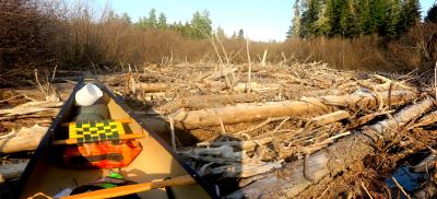
We were on the trail, heading south back to the canoe, at a quarter to 8. Our fresh legs made quick work of both the road walk and the woods travel. We had no trouble retracing our steps to the canoe, still tied to that tree near the beaver dam.
View attachment 130899
Canoe is still where we left it
As before, Hope led and found the path while I carried the canoe. The forest had its share of awkward blowdowns and trees 32" apart, but compared to Confusion Hill it was a good portage.
View attachment 130900
Dragging through the alder
View attachment 130901
A walk in the park
The 1.3mi road walk section of the portage was long but uneventful. Once you get in the zone, you don't want to stop.
The theme of the back half of this trip was "defining adversity down". To get to open water on Moose Pond, we had to drag down a steep slope impeded by several large blowdowns and push through / drag over about 50 yards of dri-ki. This was so much less of a pain than dragging the canoe over Confusion Hill that it hardly even registered.
View attachment 130902
Almost on Moose Pond
We were paddling again at 10:15am. I felt a great sense of satisfaction when the canoe was floating free on Moose Pond. We had made the crossing from the Penobscot to the Aroostook watershed. From here we were undertaking a "normal" canoe trip, on bodies of water at least mentioned in the AMC River Guide. It's all in the book.
There is a sporting camp on Millinocket Lake, and as we first emerged on the big lake we saw a float plane take off and head north. I wondered where they were going. Just a note on geography, this Millinocket Lake is unrelated to the one near the town of Millinocket, 50 miles or so to our south.
Moose Pond, Little Millinocket Lake and Millinocket Lake were all full of dri ki, and we saw few opportunities to make a rough camp or even a comfortable shore lunch. The exceptions were the passage between Moose and Little Millinocket and this gravel bar on the south side of the big lake.
View attachment 130903
Shore lunch on a Millinocket Lake gravel bar
Unlike the view from Matagamon, the mountains on the horizon here were unfamiliar. The pointy peak in the distance is Beetle Mtn.
Continuing east down the lake, we detoured into a deep cove to enjoy the scenery. OK, actually were were looking for the dam, and this wasn't it, but it was pleasant.
View attachment 130904
This deep cove is not the outlet
We found the dam and the portage, not marked. It might also be a snowmobile trail. It was on the north side, up the hill, right then left, down to a landing, about 0.3 miles. One big blowdown, but still very low on the trip adversity scale.
View attachment 130905
Easy put-in on Millinocket Stream
Descending Millinocket Stream through Millinocket Falls we had a fun whitewater run, adding another flavor to this already diverse trip. The book says Millinocket Falls is class 2, scout on the left. We felt fine just reading the river from the canoe.
We planned to finish our trip on Millimagassett Lake, so below the whitewater section we knew we had to make a right turn up Millimagassett Stream. I had a waypoint and we checked the GPS several times so as not to waste any effort backtracking. Note that heading up Millimagassett Stream there is a fork about 0.25mi above the confluence. Keep right to stay on the stream leading to the lake.
The ascent up Millimagassett Stream got our legs wet but was only nominal on the adversity scale. Not as hard as the East Branch or a portage. We were in good spirits as we knew we would get to camp at a reasonable hour.
We arrived at camp on an island in Millimagassett just before 4pm. (I'd previously camped on the island at the western end of the lake, this time we were on the one closer to the outlet.) Miller Time! From here we were only a short lake paddle and .3mi road carry from a vehicle.
This was a real campsite, even noted on the DeLorme Maine Atlas. There was a big pile of firewood. It was not pristine, but a lot of the junk was decades old, so it had a lived in, dive bar vibe to it. There was a large if wobbly fire ring, two picnic tables and lots of open space. The good life.
View attachment 130906
Campsite on Millimagassett Lake
View attachment 130907
View west from camp; later the clouds closed in
Day 4 & afterward: Home from Millimagassett Lake
We arose to a misty morning and paddled out. Rain was in the forecast so we didn't wait around. We saw a couple of fishermen in a square stern canoe, the first people we'd seen since Matagamon. The quarter mile carry up to the parking area was easy, and soon we were on the road and on the way home.
View attachment 130908
Back at my car on Matagamon
Looking back, this was a 4 day, 3 nite trip, less than 72 hours in the wilderness, and yet it seems like so much happened. I can't wait to do another. Still, I may need a cushy float trip to recover before taking another adventure from Canter's guide.
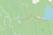
Have you ever finished an off-the-beaten-track trip and thought gee, wouldn't it be nice to have a map of that? Well, when you trip with a GIS expert, these things happen. Click on the map image for a slick "story map" with photos.
https://arcg.is/11PuP9
View attachment 130909
An Extraordinary Adventure in the Northern Reaches of Maine's Backcountry

arcg.is
Word of caution to novices: don't let the map give you the impression this is a tourist bureau approved water trail. It's an interesting historical route that can be followed with difficulty by determined paddlers.

")