• Happy International Mermaid Day! 🧜🏼‍♀️

September Allagash Advice

Joined
May 8, 2021
Messages
16
Reaction score
1
I have done the Allagash three times in May back in the late 80’s. Even met Milford Kidney at Lock Dam.

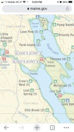
I am planning a trip this year in mid-September. The water will be too low to put in above Allagash Lake. I am trying to decide where to put-in. My buddy wants to see the trains. What about Indian Stream? What if the water is low? I don’t want to put in at Telos. Too much lake work. What about Smith Brook?
 
I floated/walked/lined a canoe down (and back up) Indian Stream in June with good water levels. In September, especially this year if things continue as they did in the spring, you might be pretty dry.
 
I think Indian Stream is a good option almost any time. It usually requires wading, but the footing isn't difficult and it's short enough that it doesn't become tedious. A couple years ago I did an August out and back trip from Indian Stream up to Allagash Lake, and while Allagash Stream was a hike I didn't have any trouble with Indian Stream.

I believe there is now a parallel foot trail if one wants to portage, an Eagle Scout's project. I haven't walked it myself, so I can't say if it's better or worse than wading the stream.

Smith Brook would be an off-the-beaten-track approach. If you do that, write up a trip report! That used to be a route in days of old.
 
I don't believe Smith Brook is a legal AWW access point. There are falls right at John's Bridge Road that can be carried. I don't know what the brook looks like after that.

I can't quite recall if we have ever run Indian Stream, but we have lined/waded it and I do believe there is a carry trail now. It is not far down the stream to the lake.

Cheers.
 
Last edited:
I don't believe Smith Brook is a legal AWW access point. There are falls right at John's Bridge Road that can be carried. I don't know what the brook looks like after that.

Cheers.

Yeah, if it’s not shown as a legal access point on the official AWW map, then it is probably not allowed.

It looks like Indian Stream is about 1/4 of a mile. If there is a carry trail there, that would be a possible alternative to dragging the stream. Either way, I think Indian Stream will be a viable access point in low water. Hopefully, we will get some rain this summer, but I would not bet on that.

I did the Upper West Branch of the Penobscot to fish The Fox Hole in September 2018. The water was very low almost to the point that we had to abort the trip. We are in a long-term drought. Also, water is staying warm later. Brook trout and Salmon spawning are happening later. I wonder whether the State will extend the general fishing season past October 1 one day.
 
Last edited:
Not looking good tor September unless things change. 1000 cfs or more is ideal.. Under 500 and there is walking no matter where you put in. Already the Allagash is running behind median water levels for this time of the year.

You can walk into the locomotives. Google Maps will give you directions. Its about a mile in and back from parking.
 
You can walk into the locomotives. Google Maps will give you directions. Its about a mile in and back from parking.

Really, it looks WAY longer than that and I don’t see where parking would be legal.

If water is low - - which I expect it will be - - my plan would be to put-in at Indian Stream and take-out at Michaud Farm. From what I have read, this should be do-able in any conditions short of the Apocalypse. Correct me if I am wrong about this
 
The tramway portage is .6 miles. Using that as a scale of reference the nearest road is approximately 3 miles from the trains. I believe the only way to see the trains is to canoe to either end of the tramway on either Chamberlain lake or Eagle Lake and walk from there. I’ve been there three times before myself.
 
They do have a legal parking area and in one of the last videos I saw of the trains, there were piles of planks near the Lombard for a new treadway. I'm headed in there the beginning of June.
 
This thread inspired me to reread the rules (https://www.maine.gov/dacf/parks/park_passes_fees_rules/aww_rules.shtml). A few observations:
  • The carry trail along Indian Stream is on the list of foot trails (sec 2.15), so it's legit. Hopefully it's even maintained.
  • The rules are quite specific about access to the watercourse by motor vehicle (sec 2.10), but afaict access by the sweat of one's brow (such as Mud Pond Carry, Musquacook Stream or perhaps Smith Brook?) is legit, although as a practical matter parking a vehicle might be a problem.
  • I know I've seen non-paddlers at the trains, and even seen a ranger give people directions to the trailhead. I assume it's far enough from the watercourse that it doesn't run afoul of the access rules. I have to admit I wish it wasn't so.
Nothing in the rules about rain. Hope we get some.
 
The carry trail (mostly a boardwalk) was put in around 2014 and with all the work that went into it, I'm sure they are maintaining it.

From YC's video, This is a Trailhead
2Screen Shot 2021-05-14 at 6.58.18 AM.png
 
So this road and trail to the trains is relatively new then. (I am an old-timer. I have not been to the Allagash for 30 years). It is still not shown on the official AWW map.

I assume it was part of the logistics necessary to get equipment in for the tramway restoration project.
I don’t like the idea of drive-in access. IMHO they should close the road and make you have to canoe in to be able to see the trains.
 
Last edited:
I've walked a lot of that trail back towards the trailhead from the rains. It's nothing more than a hiking trail, it wouldn't be used for maintenance or reconstruction of any size. I think a lot of that material was most likely brought in during the winter as they did bring in the stone during the shoring up of the locomotives.
 
So this road and trail to the trains is relatively new then. (I am an old-timer. I have not been to the Allagash for 30 years). It is still not shown on the official AWW map.

I assume it was part of the logistics necessary to get equipment in for the tramway restoration project.
I don’t like the idea of drive-in access. IMHO they should close the road and make you have to canoe in to be able to see the trains.

Most visitors to the trains do not come in by foot or canoe or drive to the parking lot. It is a wildly popular snowmobile area and I believe the snowmobile trail became the road. You might be upset too that Chesuncook Village now has road access.
The AWW is not a wilderness. It is part of a working forest.
Without snowmobile access the trains would have toppled over years ago. All the equipment necessary to right the trains was brought in by snowmachine.

https://www.maine.gov/dacf/parks/discover_history_explore_nature/history/allagash/index.shtml
 
Back
Top