• Happy Mickey Mouse Day (1928→)! °o° ♨️🚢

Request for Insight on the Owyhee River, Oregon

Joined
Apr 17, 2023
Messages
332
Reaction score
705
Location
Nantucket, USA
My annual tripping group may be coalescing around the idea of a trip on the Owyhee in Oregon. We're in the preliminary stages of research and would love being pointed in the right direction. A survey of CT.net yields no trip reports and only the following relevant references, which seem to indicate access and shuttle logistics that will require careful planning.
The Green has a lot of class III rapids and the longest shuttle around except for maybe the Owyhee River in Idaho.
but I can stretch a poling adventure into about a week in some cases. The Owyhee River at Three Forks being one of those.
For instance, the road that goes to the upper Owyhee river - a popular canyon run with a very short season - can be used if you call ahead to the landowner with detailed description of your party and vehicle that will be used. Forget to ask permission or show up looking different than described.......expect to be escorted (or towed) off the property, likely with some hostility.
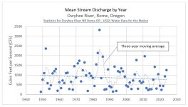
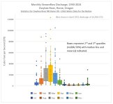
I understand the Owyhee flows are snowpack dependent: trips are viable March through early June, April and May being prime season. Daily temperature fluctuations are significant. We've done cold water trips before (Machias, John Day) and big volumes (John Day at 14,000 CFM+) but those elements coupled with the remoteness of the Owyhee gives me pause. A preliminary web search yields much more information on rafts and kayaks than open canoes. Watching YouTube videos leads me to believe that a spray cover could be warranted: we swamped repeatedly on the John Day. Overall, we're a solid group of paddlers.

So the question is, can we pick a feasible section of the Owyhee that would accommodate a trip of 4/5+ days without irresponsibly stretching the limits of heavily loaded canoes?

Given the challenge of managing our collective schedules, we'll certainly need to commit to a set of dates and keep our fingers crossed for appropriate flows; setting a contingency plan for another river if the weather disagrees.
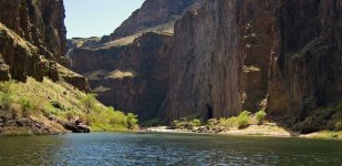
The-Lower-Owyhee-canyon-Oregon-Grand-Canyon-scaled-488613366.jpg
 
That photo looks familiar. Three Forks, right? I picked up a group there a couple summers ago.

That would be the takeout for the upper runs with very remote and inconvenient access. Putting in there takes you through a lot of class 3, some 4, and a couple of class five (one is+5) on the way to Rome. Most people who I know that have done it in canoes get in at Rome and take out at Birch Creek, just above Owyhee Reservoir. That has several cl3, and a couple cl4. A lot more camping options, I think. Still a significant shuttle, but easier since Rome is right on the highway. Birch Creek requires high clearance and sometimes 4wd.

I still haven't done any of it yet (that poling from Three Forks trip keeps getting bumped), and it's unlikely that I'll do any of the whitewater in a canoe at this point. But I would be glad to help you with the shuttle if timing doesn't conflict.
 
BTW, the BLM website probably still has a link somewhere for river maps of the entire drainage above the reservoir. Let me know if you can't find it. Worst case, if it's not there anymore, I can scan my hard copy.
 
@Steve in Idaho thank you! Very kind of you to offer shuttle support. I'd love the occasion to meet you. Given that you've picked others up on this river before, is that a service you do routinely, or are you just the nicest guy in Idaho?

That photo looks familiar. Three Forks, right?
I sourced this photo from the Momentum River Expeditions website, which seems to indicate its location on the lower Owyhee.

In line with your advice, I received a couple of very helpful direct-messages from another forum member, who also pointed me towards the lower section of the river, specifically the Rome to Leslie Gulch section. Barring headwinds, the eight miles of the reservoir might prove an enjoyable "glory lap" at the end of a trip: recounting our heroics (and idiocy) over a few, final, rationed beers!

Further research yields, an out-of-print river guide from the BLM: https://www.blm.gov/sites/default/f...Idaho_Bruneau-Jarbidge-Owyhee_BoaterGuide.pdf

And a pretty good trip summary from and organization called The Mountaineers: Owyhee River (Lower): Rome to Leslie Gulch — The Mountaineers
 
Steve is right. This river is one of the most remote in the lower 48. It is a very flashy watershed. Flows can come up quickly. Low flows are even worse over sharp basalt and lava rock. No place for canoes. Very hard to plan ahead because of wild fluctuations in flow. Some years it is unrunnable even for rafts and kayaks. The shuttle is over 8 hours.
 
I have a friend that used to solo canoe (MR Rx Explorer) part of the Owyhee on an almost annual basis (his dog is even buried there, having expired on one of the trips). I don't know the details, but it wasn't the whitewater sections, and obviously water level was critical. I've seen pix, and I always wanted to do it--just a neat looking trip in the middle of nowhere.
 
H
@Steve in Idaho thank you! Very kind of you to offer shuttle support. I'd love the occasion to meet you. Given that you've picked others up on this river before, is that a service you do routinely, or are you just the nicest guy in Idaho?


I sourced this photo from the Momentum River Expeditions website, which seems to indicate its location on the lower Owyhee.

In line with your advice, I received a couple of very helpful direct-messages from another forum member, who also pointed me towards the lower section of the river, specifically the Rome to Leslie Gulch section. Barring headwinds, the eight miles of the reservoir might prove an enjoyable "glory lap" at the end of a trip: recounting our heroics (and idiocy) over a few, final, rationed beers!

Further research yields, an out-of-print river guide from the BLM: https://www.blm.gov/sites/default/f...Idaho_Bruneau-Jarbidge-Owyhee_BoaterGuide.pdf

And a pretty good trip summary from and organization called The Mountaineers: Owyhee River (Lower): Rome to Leslie Gulch — The Mountaineers

Haha! Not the nicest guy in Idaho, but I live near the Owyhees and I'm not one to pass up an excuse to visit them. The group I picked up were some younger guys I used to paddle with until they got too much into whitewater for me.

Ppine is right that the river can be flashy and it can be bony - especially in its upper reaches. And oar rafts are the most popular crafts getting in at Rome from what I've seen. But some people do run it in properly outfitted whitewater oriented canoes. I have been told that some of the more difficult rapids can be sneaked at higher flows and portaged at lower flows. But yeah, it is a pretty serious trip. Photos I've seen are pretty awesome.

The shuttle for the upper runs probably is eight hours or more, which is why that group was happy I could pick them up (they retrieved their put-in vehicle all the next day later). But Driving time from Leslie Gulch to Rome is only two hours. Rome to Birch Creek might be a little shorter, but I would expect it to take about the same amount of time, due to the condition of the "road".

Short side trips on the way into Birch Creek can include Jordan Craters (some of the youngest lava beds in the continental US) and a view into Leslie Gulch from above on Mahogany Mountain - both of which are definitely worth the time.

BTW, getting out at Leslie Gulch can b a slog in anything suitable for whitewater. Most people choose to get out at Birch Creek if the road there hasn't been washed out. There is camping with vault toilet facilities at Leslie Gulch, and the Gulch is another place definitely worth visiting and hiking though - so there's that.

One could also camp just off the route between Rome and Birch Creek at Cow Lakes, at the southeast end of Jordan Craters.

My thoughts.... if you choose to go all the way to Leslie Gulch, you should set aside some time to do some day hikes there if possible. But that also applies to Birch Creek.
 
Back
Top Bottom