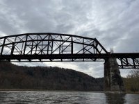
My wife, father-in-law and I just returned from two nights and 35 miles on the Allegheny River from Franklin to Emlenton. It was a perfect weekend to canoe.
We drove out to Emlenton after work Friday, November 3, and left our shuttle vehicle at the parking lot for the Allegheny Trail, a rail trail that runs along much of the river on this stretch. We then piled into one vehicle with the canoes on the trailer and drove to the Samuel Justus Trailhead, arriving just after 6:00. We traveled about 2 miles downstream to the Deep Hollow camping area river left. This camping area has three lean-tos, tent pads, fire rings and porta-potties. The takeout is a little tough to find and navigate, but well worth it. This is a wonderful resource, although close to Route 322 and the highway noise. Nevertheless, we had a nice fire and dinner and enjoyed a few glasses of wine prior to heading to bed about 10:30. Temps hovered in the mid-40s.
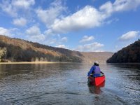
Saturday, November 4, we arose shortly after sunrise and completed our camp chores and breakfast. We managed to get onto the water by about 10:00 under partly sunny skies, very light winds and temps that would rise to about 55 degrees. It was a lovely day to paddle! My wife and father-in-law paddled our tank; the 17' aluminum Grumman with most of our gear. I soloed in a 14,6 Wenona Royalex sitting backward in the bow seat and using gear to establish some semblance of trim. It worked fine.
The river is dam controlled with all of this outflow coming from Kinzua Reservoir. If not for that, river levels would be too low to paddle this time of year. The canoe hulls never touched river bottom this trip. This is an extremely beginner-friendly stretch of river with excellent camping. There are numerous islands on which camping is permitted. A few miles below Franklin, the river leaves the paved route behind. While there are still some structures and gravel roads along the river, much of it is undeveloped and beautiful, even past the peak for fall colors. We managed a consistent 4 miles per hour. Typically, the river has 1-2 mile sections that move very well with some easily managed wave trains. These are broken up by 1-2 mile sections of calm that can be a hassle if you end up with a southerly wind. The river is wide enough that sweepers and strainers are never an issue.
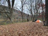
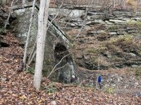
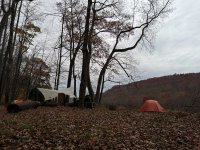
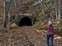
We made Danners Rest at the 14-mile mark by 1:00 and had some lunch. Danners Rest is in Clear Creek State Forest and is another excellent camping resource. There are picnic tables, fire rings, a pit toilet (being replaced by a vault toilet) and a piped spring (not potable). The area sits across the river from the Kennerdell Tunnel, a destination unto itself. We busted the stove out for lunch and made some hot drinks for our next stretch of paddling. We looked at a North Country lean to river left at the 19-mile mark. The NCT shares the route with the Allegheny River Trail here. We weren't interested in sleeping in the lean to and the surrounding area was not conducive for tent camping, so we paddled on. At around mile 22.5, we found a wonderful site river right that is in Clear Creek State Forest. The site gets a lot of use but was otherwise clean. We left it better than we found it. We made camp by around 4:45 and enjoyed dinner made over the Dragonfly stove, some more wine and excellent views as the colors changed with the setting sun. A peaceful night was had.
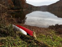
Up on Sunday, November 5 before the sun! We set the clocks back, so we were all well-rested. It got coolish overnight and was about 38 degrees by morning. However, there were no clouds in the sky and the sun warmed things up quickly. It got close to 60 degrees! We were on the water by 9:00. We made a number of stops today. There are islands at approximately miles 25 and 27 that have wonderful camping on them. We also stopped to check out the Rockland Tunnel, another railroad tunnel meant to shorten the route by cutting off large oxbows in the river. Finally, at about mile 31, there is a much nicer lean-to on the Allegheny River Trail/NCT. At mile 35 is the takeout in Emlenton. We made that by 1:45, completed the shuttle, had a beer and an early dinner at Emelenton Brew Haus and headed home.
This is a wonderful trip for beginners and families, which is the reason I posted it here. Another great Allegheny River trip we've done a number of times runs from Buckaloons Federal Campground downstream of Warren to Tionesta, PA. The entire stretch of river from the reservoir to Emelenton is really nice, but novice paddlers should be aware of the Oil City rapids upstream of Franklin.
We drove out to Emlenton after work Friday, November 3, and left our shuttle vehicle at the parking lot for the Allegheny Trail, a rail trail that runs along much of the river on this stretch. We then piled into one vehicle with the canoes on the trailer and drove to the Samuel Justus Trailhead, arriving just after 6:00. We traveled about 2 miles downstream to the Deep Hollow camping area river left. This camping area has three lean-tos, tent pads, fire rings and porta-potties. The takeout is a little tough to find and navigate, but well worth it. This is a wonderful resource, although close to Route 322 and the highway noise. Nevertheless, we had a nice fire and dinner and enjoyed a few glasses of wine prior to heading to bed about 10:30. Temps hovered in the mid-40s.
Saturday, November 4, we arose shortly after sunrise and completed our camp chores and breakfast. We managed to get onto the water by about 10:00 under partly sunny skies, very light winds and temps that would rise to about 55 degrees. It was a lovely day to paddle! My wife and father-in-law paddled our tank; the 17' aluminum Grumman with most of our gear. I soloed in a 14,6 Wenona Royalex sitting backward in the bow seat and using gear to establish some semblance of trim. It worked fine.
The river is dam controlled with all of this outflow coming from Kinzua Reservoir. If not for that, river levels would be too low to paddle this time of year. The canoe hulls never touched river bottom this trip. This is an extremely beginner-friendly stretch of river with excellent camping. There are numerous islands on which camping is permitted. A few miles below Franklin, the river leaves the paved route behind. While there are still some structures and gravel roads along the river, much of it is undeveloped and beautiful, even past the peak for fall colors. We managed a consistent 4 miles per hour. Typically, the river has 1-2 mile sections that move very well with some easily managed wave trains. These are broken up by 1-2 mile sections of calm that can be a hassle if you end up with a southerly wind. The river is wide enough that sweepers and strainers are never an issue.
We made Danners Rest at the 14-mile mark by 1:00 and had some lunch. Danners Rest is in Clear Creek State Forest and is another excellent camping resource. There are picnic tables, fire rings, a pit toilet (being replaced by a vault toilet) and a piped spring (not potable). The area sits across the river from the Kennerdell Tunnel, a destination unto itself. We busted the stove out for lunch and made some hot drinks for our next stretch of paddling. We looked at a North Country lean to river left at the 19-mile mark. The NCT shares the route with the Allegheny River Trail here. We weren't interested in sleeping in the lean to and the surrounding area was not conducive for tent camping, so we paddled on. At around mile 22.5, we found a wonderful site river right that is in Clear Creek State Forest. The site gets a lot of use but was otherwise clean. We left it better than we found it. We made camp by around 4:45 and enjoyed dinner made over the Dragonfly stove, some more wine and excellent views as the colors changed with the setting sun. A peaceful night was had.
Up on Sunday, November 5 before the sun! We set the clocks back, so we were all well-rested. It got coolish overnight and was about 38 degrees by morning. However, there were no clouds in the sky and the sun warmed things up quickly. It got close to 60 degrees! We were on the water by 9:00. We made a number of stops today. There are islands at approximately miles 25 and 27 that have wonderful camping on them. We also stopped to check out the Rockland Tunnel, another railroad tunnel meant to shorten the route by cutting off large oxbows in the river. Finally, at about mile 31, there is a much nicer lean-to on the Allegheny River Trail/NCT. At mile 35 is the takeout in Emlenton. We made that by 1:45, completed the shuttle, had a beer and an early dinner at Emelenton Brew Haus and headed home.
This is a wonderful trip for beginners and families, which is the reason I posted it here. Another great Allegheny River trip we've done a number of times runs from Buckaloons Federal Campground downstream of Warren to Tionesta, PA. The entire stretch of river from the reservoir to Emelenton is really nice, but novice paddlers should be aware of the Oil City rapids upstream of Franklin.
Last edited: