• Happy Weed Appreciation Day! 🌱🌿🌻

Not Maine but nice plan B, ADK Low’s Lake

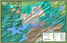
Hey Coldfeet, I'm thinking of going to Lows this coming weekend and have a couple questions if you don't mind. Did you put in at the lower dam or somewhere else? Were you able to get a map of the lake that had the campsites marked, if so where? It looks like a great destination but I'm not finding much straightforward info on it.


The lower dam is the only designated public launch site on Lows. It may be possible to enter from the Horseshoe Lake access road easement area, but it is a longish portage. You can also access/bushwhack/trail from Lake Lila, or bushwhack to a trail from Cranberry Lake The public is not allowed road accesss directly at the upper dam. The only other option is if you are with the Boy Scouts and access Sabattis Scout Reservation during the resident camping season.
 
Last edited:
Were you able to get a map of the lake that had the campsites marked, if so where?
Hi Al, Try here, this should help.

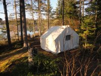
My favorite is Virgin Timber Landing at the west end of the lake. If the wind kicks up from the west you can still do some exploring, north to Grass Pond, south to Bog Pond. It's a long paddle into VTL, I have done it many times with my wall tent outfit in one afternoon, beautiful campsite.


DSC00477.JPG
 
Thanks for the info gents. If nothing else I took photos on my phone. While I'm up there I'll see what is available as far as guide books and maps for future reference.


Robin, I don't think I'll be camping that far in as I have to drive 6 hours after getting back to the truck but I would like to check it out on a day trip from a basecamp. That is unless there is a hike that would take us to a peak or vista.
 
map of the lake that had the campsites marked

https://andyarthur.org/data/map_023925_c.png

map_023925_c.png
 
Thanks for the info gents. If nothing else I took photos on my phone. While I'm up there I'll see what is available as far as guide books and maps for future reference.


Robin, I don't think I'll be camping that far in as I have to drive 6 hours after getting back to the truck but I would like to check it out on a day trip from a basecamp. That is unless there is a hike that would take us to a peak or vista.
A nice hike to a Vista is right at the upper dam, about 45 minutes up and 20 back down. Walk up the hill past the dam to the right and look for the second sign in register

Jason
 
Don't stay there in October... you will freeze to death. You have the fetch of the whole lake, and hardly any vegetation to block the wind. Bring a good tarp!


Jason
 
Great report and commentary from others and so timely for me - I am planning another trip in that area, just not sure of the exact destination yet - and Low's Lake is on our short list.
 
I'll give another vote for site 18. If the weather is questionable or you want to get back to the put-in fairly quickly a reasonably flat and protected site is #10 which offers a number of spots to put a tent or hammock and is only about a 15 minute paddle to the upper dam. It's on the bog flow - right side after you pass the floating bog . You would still be a distance from the larger Low's lake but in an area protected from high winds.
Raquette River Outfitters in Tupper Lake has a paddlers and hikers map "Lows Lake and Bog River" that shows all the campsites on the Bog River and Lows Lake with a description of all 40 campsite sites on the back.
 
Back
Top