We have a lot of snow and two more feet coming. Total snow in last week will total more than 150 cm by the end of today. My hubby is tired. It just won't stop here in Maine
-
Happy National Pink Day! 🌷🩰🦩
You are using an out of date browser. It may not display this or other websites correctly.
You should upgrade or use an alternative browser.
You should upgrade or use an alternative browser.
Marshall Lake 2015
- Thread starter memaquay
- Start date
Whoa, hold on there just a minute. I've got dibs on the snow re-gifting thing. Mihun's coming for my snowbank account first! YC, your's will just hafta wait.We have a lot of snow and two more feet coming. Total snow in last week will total more than 150 cm by the end of today. My hubby is tired. It just won't stop here in Maine
Seriously though, how was the snowshoeing? I guess your lake is fully frozen by now? Is it spring fed, or is it stream fed?
There are huge drifts on the lake. It's spring and stream fed. Even the snowmobiles are not going on it. The ice is three feet deep. I don't have the ability to snowshoe. I am not strong enough. Chemo has robbed me of 20 lbs in one month and all my immunity. It hits the bone marrow. That's why I think canoe tripping is a thing of the past. When done it takes a couple of years to regroup
Sorry YC, I didn't realize you'd hung up your snowshoes for now.
Keep as well as can be, and looking ahead. The regrouping, rethinking, readjusting might be like trip planning.
Let's look at it that way.
You've got 150cm of snow!? I guess I'll be okay with my 25cm. But I still want my snow transfer to Manitoba to come first. I wonder how to get it there? What we need is a trucker with a bit of extra time. Hmm.
Last edited:
- Joined
- Dec 12, 2014
- Messages
- 364
- Reaction score
- 4
We have a lot of snow and two more feet coming. Total snow in last week will total more than 150 cm by the end of today. My hubby is tired. It just won't stop here in Maine
I thought of you down-easters as I was removing the 18-inch (45-cm) block of solid snowpack from my double-wide driveway this morning. I was quite happy to have only that much to clear.
I still need to dig up some maps. My mapmaker son still hasn't followed through on his offer of installing and demonstrating map software here for me. I also keep e-mailing him for old topo maps. We'll see.
I'll send you some stamps, you can mail it to me. At the rate of ground delivery by Canada Post it should get here by Summer when we need to cool down.
Maps... I don't have mappage of the area, just used google maps/earth to follow Robin's route and Mem's other trips in the area. He could have a mecca of canoeing if we get an outfitter and some interest in the area.
Maps... I don't have mappage of the area, just used google maps/earth to follow Robin's route and Mem's other trips in the area. He could have a mecca of canoeing if we get an outfitter and some interest in the area.
No shortage of routes, that's for sure! It's just keeping them all open...that's a full time job.
No shortage of routes, that's for sure! It's just keeping them all open...that's a full time job.
Er, are we gonna get shanghaied into port clearing as part of our "canoe trip'"?
I wanna know, cause I might hafta bring more beer.
Ha ha, nope, gonna have it all cleaned up from the school trip in June. Hopefully have tons of firewood stacked at each campsite too.
We sure are looking forward to this trip. Mind you, if the fishing in Gripp is as good as Robin said, you all just leave me there, I'll find my way out.
I'm not sure if you will find the fishing as good as I experienced, (shoulda been here last week syndrome
 ), but you can't beat the atmosphere. Nice place to be "left"
Robin, is that the island campsite you found on the north arm of Grip? I seem to recall you said you thought it might be a good site for the kids this June.
Yes, it is, it has a wall tent frame set up, lots of room to camp.
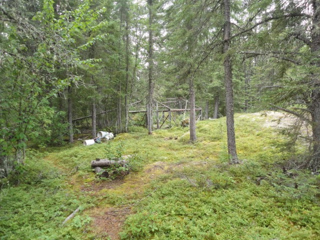


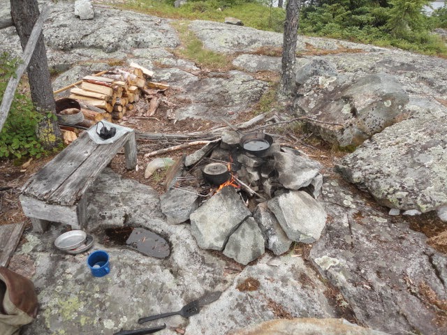
Love the pics of BARE GROUND!
dang, that site looks sweet, we will definitely be staying there in June, much more room than the usual cliff site we use. That's a great find Robin, thanks so much!
Your Welcome, I hope it works for your group. I enjoyed my lunch there, very peaceful location.
So like, I'm starting to work out my vacation time for this year, do we have dates yet for this CT Gathering trip?
I get 12 paid vacation days, which equals 3 weeks. I'm doing OT to add bank time to get 4 weeks, or more. If I take only weeks after a long weekend I could make it easily into 5 weeks off this Summer. The G'Town trip is going to be 2 weeks for us, not sure which end we will tag the extra days onto yet though.
Not enough time off for me I tell ya. We have a fellow at work who goes to Mexico in November and comes back in March, my ideal would be take June through September off, much like Mem gets. Being away from work is more important than being there for me nowadays.
Well, Brad says he can be here on the 7th or 8th of August, so we can play it out from there. I'm not going to make any firm schedule for travel, we'll just travel with group consensus. Since we aren't doing the loop, the travel schedule is pretty flexible. I'm so used to pounding put miles every day, I'm thinking it might be time to slow down and explore. I'm thinking of a rough travel schedule something like this
Day One: Somewhere on Marshall (one port, some paddling)
Dat two: Grip (Three short ports, 10-17 k of paddling depending on previous day)
Day three: Grip (I would really like to explore fishing opportunities around Grip, looks like a nice campsite too)
Day four: Water falls campsite (3 or four short ports, 24 k of paddling)
Day Five is problematic, it will either be a very short day (15 K, bug hole campsite) or a very long day (you don't want to know how long)
Day Six: Esker Hilton Beach site (probably two short ports, 25 k of paddling)
Day 7: If everyone is willing to do a 30 K paddle and one short port, we will get to stone lake
Day 8: Back up to Stewart Lake (one port 10 k of paddling), or paddle to Berger Lake (one port, 20 k paddle, carve out old campsite)
Day 9: Back to Esker Hilton or back to bridge.
Day 10: Wind day, extra travel day.
I'll have a sat phone. I figure everyone can look after their own food, although hopefully we will have some communal fish frys. As long as there is no fire ban on, we'll have fires every night. I've got extra gear and can even provide a canoe or two if people don't want to haul one up here. We can resupply at the bridge on Day 6, so don't be afraid to bring lots of food and beverages.
Like I say, that's a tentative schedule. We'll be having a few frosties at my place the night before we leave. we've got lots of room to put people up before and after the trip too.
What maps do we need for the area? Technically we don't need them since you are intimate with it, but from the topo's I can get a feel for where the best fishing should be prior to arrival, besides, I love my maps. My DVD's of all the topo's of Manitoba include most of WCPP too and I pore over those constantly.
I doubt we have ever done 30k of paddling in a single day, should be a challenge, however, what Christine can handle might slow you all down. Our single longest days have always been Wallace to Leaf Lake, 25km and 10 ports. The river out of Summit is all downhill is it or only until the next river, then uphill?
I doubt we have ever done 30k of paddling in a single day, should be a challenge, however, what Christine can handle might slow you all down. Our single longest days have always been Wallace to Leaf Lake, 25km and 10 ports. The river out of Summit is all downhill is it or only until the next river, then uphill?
Everything is downstream until we come back up from Stone, then we would be travelling upstream on the Kap back to the bridge. However, Kap is big slow river at that point. We can break things up smaller if 30 k is too much..as i say, we'll play it by ear, there is really no destination just the journey.
Similar threads
- Replies
- 13
- Views
- 2K
- Replies
- 8
- Views
- 539
- Replies
- 6
- Views
- 791