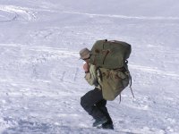
I haven’t done many portages. There was a BWCA trip were I made about 30 portages, and I’ve carried about ten times in the Adirondacks, but that’s about all. I wouldn’t call any of the portages joyful, but neither were they Hellish.
for those who want to read portage ordeals, I’ve copied from myccr.com Tom McClouds description of his group’s portage on the Petite Mecatina. It took them something like six days to portage around a three-mile canyon. Below read the tale in McCloud’s words:
6 August 03. The objective of the first hike was to scout the portage route, to see the canyon and the cascades, determine if there might be sneak routes at water level, and also to determine where we will re-enter the river at the end of the canyon. So with heavy packs on, we head out. Soon we realized that this forest was extremely thick, and we made poor time. At noon were on top of a bluff overlooking the rapid that had stopped us yesterday. In the sun it was blisteringly hot. We did not find the anticipated caribou-moss-covered balds at the top, where the walking would be easy, nor were there the game trails to follow through the woods that wed hoped for. In the forest you could not see the person only 50 feet in front. At 3 pm break we were nowhere near the end of the canyon and had drunk all our water. It had to be in the mid-80's. We needed water and a place to camp before dark. On the topo maps a lake was shown not far away so the coordinates were dialed into a GPS, and we headed in that direction. Ive come to call this camp Tent Lake, which according to the GPS was 1.8 miles, as the crow flies, from our camp of the previous night. Admittedly we did not move in a straight line, but after 8 hours of some of the most difficult bushwacking Ive ever done, it was a discouraging thought to contemplate repeating this twice more.
Up at dawn, each of us packed a light pack with some food, and extra clothes, figuring that we could not make it back here with boats in a day. It took 3+ hours to reach the boats. Then began the toughest portage Ive ever done, pulling and shoving the canoes up hills, and sideways through the dense spruce trees. Portaging in the traditional sense, canoe overhead, is not possible here. There are many down dead trees that add to the problems. It took hours and hours, just to get boats and packs onto the boulders near the mouth of a stream on the downriver end of Granite Island Rapid, which wasnt even a third of the total portage distance, and we were real tired. After a slim supper we put on all the clothing we had, a couple of us used deflated airbags as blankets, and curled up. It became colder. Sometime during the night the fire died, and had to be rekindled. This night took its toll.
Then we started to move up the creek. Well, kind of. With packs on we started to walk up along the creekside, but this foray did not last long. The viewpoint was expressed that this portage route was an impossibility, that the 1985 group MUST have used some other creek. The argument ran something like this Suppose we had no information whatsoever about this river? What would we be doing? Wed be probing on downriver until we came to something that we absolutely could not get around. We havent gone that far yet. Well, I cant argue with that, because its premise is correct. It might even be true. We dragged the boats down to the Mecatina and headed around the next bend. In only a few hundred yards we were at another major rapid, a long and bouldery class 4/5, which began with a ledge. If we continued to portage this rapid the canoes would have to go over boulders the size of vans and panel trucks, and the next rapid below was clearly unrunnable. Still uncertain whether we were at the head of the impassable cascades, one of us made a 3 hour scouting hike. On return he had few words: the impassable canyon was just around the bend. The river was white as far as he could see. Both canyon walls were smooth rock at a 45 degree angle descending into the water, and passage through at water level was impossible. Resigned, we retreated upriver. Back at the mouth of the creek for the second time, and not wanting to spend another night here in the open, each of us picked up his second pack and, around 2 pm, started to hike toward Tent Lake. As you would guess it was again torture from both trees and heat. A GPS position check was made every half hour. At one point we were 0.3 miles away from the tents, and a half hour later 0.5 miles away! It was getting into dusk, and we were becoming concerned. We kind of semi-ignored the GPS and went by dead-reconning, eventually reaching the lake, but at the wrong end of it, so another 45 minutes of terrible hiking by flashlight was required to find our tents. So at 9:30 we were getting the kettle boiling to make supper. It was a really beat up group.
The alarm clock didnt sound as early as usual, and when we did gather by the fire we were not moving quickly. In talking over our situation it was clear that we had to get the boats up that creek and into the highland lakes, in order to get them close to Tent Lake, and we could not do it in one day. It was also clear that we had neither the muscle strength nor the amount of food & days needed to move all five boats. Two canoes would be abandoned. So again we packed light packs in anticipation of spending another night in the woods away from our tents and gear. The hike back to the boats went predictably slowly on yet another hot, dry day. A note was tied to a thwart of an abandoned canoe giving the date we had left and where we were headed. It was with a lump in my throat that I walked away. Losing a boat is a humiliation, a defeat. We were getting our asses kicked.
The ascent of the creek began. Its not a big creek, only 10 cfs. There were innumerable lifts of 3-5-7-feet, up small falls and over fallen trees. The going was slow, but at least we were going, and being wet from the waist down meant that the heat was less of a problem. This little creek rivals in green-ness and lushness any stream in the Smokies. The rocks were often slippery, and we all suffered many stumbles, cracks to the knees, shins and ankles. It was perhaps 5 hours of exceedingly tough work to ascend the one mile and 500 feet gain in elevation. While the guys rigged a tarp and spread out ground cloths for a place to sleep, I tended the fire and improvised a one-pot group meal from potatoes-au- gratin, milk powder, dried green peppers and corn, plus a summer sausage. The cook always likes favorable comments but I have to believe these were influenced by fatigue and hunger.
Up at first light, 4am. It had been a quiet, dry night and was again a warm morning. Now we started the different, but equally difficult task, of finding our way. It was here that we realized the problems of using maps obtained off the internet and printed on home printers: the green ink is water soluble. Both copies have suffered water damage, though stored in plastic bags. They have become borderline readable, with the green running everywhere, but the brown contour lines stayed in place. Better than nothing. As we worked through a series of small, interlocking lakes, mostly dragging between them, there were frequent map checks. At the top of a small lake where a sphagnum swamp only inches above lake level divided us from the next creeks watershed, we portaged across and found a ravine with a trickle running down it. The descent was predictably slow and very difficult because of the thick underbrush and many down trees. After 3 hours we found a very small lake, dammed up by beavers, then following 100 feet of moist boulders, there was a real lake. The trickle feeding the beaver pond MUST be draining Tent Lake, so thats where well have to go to retrieve our gear. If anything, this was the most difficult push through the bush wed done yet. Both the creek itself and the nearby forest were a tangle of fallen trees and underbrush. Another backbreaking job on top of so many others, after we were already exhausted. But the gear DID get retrieved. Reunited with all our equipment for the first time in 5 days, we loaded up, tandem now, got into the bigger lake, and immediately looked to camp. When I crawled into the tent, on this night like so many others, I was asleep instantly, and slept the sleep of the dead.
With the fire going and breakfast over, we made an effort to consolidate, lighten the loads, and get better prepared to tandem paddle. Burned were a small bottle of hand lotion, five empty film canisters, two pens and a tablet, a pair of sneakers, a full roll of canoe tickets, a shattered fishing rod, badly torn nylon pants, the lacerated Frog Tog pants and several other small things. So after this longer than usual breakfast period, we loaded the remaining gear and headed out across this good-sized lake. There was some wildlife here, including ducks, mergansers and some little guys with a white belly, gray top, black head with white patch just behind the eye. When we found the exit flow we were rather pleased that it was a swamp creek plenty big enough to float a canoe. After following that creek for a several miles, a critical decision point was reached. If we stayed on this creek we might be descending into the Mecatina canyon too soon, where we would face unrunnable cascades. The alternative was to work up-flow, through additional lakes on the canyon rim, to get to a second creek further downstream. This option involves more miles of dragging and portaging, and keeps us up on top for at least two days with very poor maps. We dont know which of these two creeks the 1985 group took, if either. The additional days of hard work and the additional food that would be consumed on the longer route tipped the balance. We decided to go with the flow.
Before long this little creek starts dropping precipitously over solid rock ledges, the first of them 30 feet! Its an interesting place, scenic in its own way. Hard to judge our rate of progress, dragging, pushing, grunting, but we keep moving. Before long we saw nothing but sky in front of us: the lip of a 100 foot fall. This one forces a portage into the woods. As you would expect it was again an extraordinarily physically difficult task, but at least it was mostly downhill. During one of these poses a thunderstorm struck. We huddled underneath overturned canoes for a half hour, then continued. As dusk was falling we were no where near the Mecatina, though we could now see it, occasionally through gaps in the trees, still far below, and we were at the lip of another hundred foot fall. To our left was a brushy field with few trees, and lots of caribou moss, which became home for the night. Big servings of spaghetti, with meat sauce and Parmesan made supper, and we could have gone for a seconds. Everyone craved those calories.
After a couple more hours of hard work the next morning we reached the big river, viewing both a big rapid above, and a big rapid below, but in both cases there was a boulder apron along the sides and we could pass there if necessary. Good news. Though still in a canyon, the walls were no longer so tight. We took an hour to rest, swim with a bar of soap and wash out clothes, the first hygiene wed practiced in 6 days. Our bodies looked bad, scabbed, bruised, bug-bitten, and thin, with lower legs, ankles and feet swollen. Since were now 3 days behind schedule...
That’s s the end of the excerpt. There’s lots more trip report, I just copied the portage part.


")


