• Happy World Hippo Day! 🌍🦛

Info on Chivelston, Harris & Harold Lakes outside Wabakimi?

Joined
Aug 10, 2018
Messages
2,151
Reaction score
7,261
Location
Blairsville, PA (about 30 mi E of PGH)
I'm starting to plan for 2025 and thinking of a mid August / early September trip in the Wabakimi area. (hopefully this past July's bugs are dead by then)

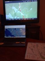
At this point, I'm considering parking in Armstrong and taking the train to Chivelston Lake (just East of the Savant Lake stop). From there, go North through Harris and Harold lakes to Savant lake and follow the Savant River to the Palisade River which can get me to Whitewater Lake. I'll check out whatever is left of the Wendell Beckwith cabins then head to Whiteclay lake, go up the Raymond River, check the pictographs on Cliff Lake and exit via Moonshine, Big Lake and Little Caribou.

My understanding is that this loop should reduce cost by starting & finishing on crown land instead of the being inside the Provincial park the whole time, it will pass through some rarely visited areas with incredible scenery, pictographs in at least 2 locations and some good fishing. The trade-off for this is that some of the lakes are huge and the portages might be rough or non-existent.

One thing I really like is that, if the portages turn out to be total bush-whacking, I'll have lots of options to shorten the route when I get to Whitewater (I have 2 weeks vacation from work but I'm figuring on taking an additional week without pay so I'll have 3 weeks at my disposal)

I've contacted Friends of Wabakimi (@jdeerfoot has been especially helpful), Ramblin' Boy, the Saugeen First Nation and Mattice Lake Outfitters for information on the state of the portages between the rail line and Savant (almost certain to be the least traveled section of the proposed route) but, so far, I've not been able to get any information and Google searches have yielded nothing.

(I've been hesitant to contact Bruce Hyer. Although I suspect he may have the best maps and information, he's also pricey and I don't want to waste his time unless I'm willing to cough up the $500 that seems to be his starting point)

Both Paddleplanner & the FOW planning map show portages existing but that's certainly no guarantee... Does anybody here have insight or an idea of where else to look for info?

Unless someone talks me out of it, I'll probably have the train dump me off & see what I find but I'd like to know that there's a reasonable chance of getting through. (and, yes, I'll post the inReach link here so you can follow along / speculate on difficulty / be glad you're not me... hell, maybe we can have a fundraiser with a "how far does he get / does he bail out via Smoothrock or press the SOS button" pool...)

IMG_20240912_165610401.jpg
 
I haven't updated this thread in awhile but I'm still researching and thinking that I'll give it a shot.

Logistics at the Armstrong end seem easy enough. I talked to Matt at Red Granite Inn and he tells me that they only have 5 units for rent but Sat & Sunday are their lightest days. They're a 5 minute walk to the train station and there is a good place to grab breakfast (Gail's grill & Bakery) on the way. (open at 7am and the train is due at 9am so should be plenty of time to eat and portage to the station).

In addition, Red Granite Inn is about 6km (4 miles) from the parking area at Little Caribou Lake so I should be able to dump my gear at the hotel, drive my truck to the take-out and hoof it back to town. (Matt offered to help shuttle if needed but it's only 4 miles... might take him up on it if it's getting late...)

Incidentally, David Jackson seems to think that the portages will be relatively clear and they're more difficult to find than they are to navigate (he tells me that he's never paddled Chivelston, however, and his first hand knowledge begins at Harris.)

I continue to be impressed by how helpful everyone I've contacted has been.
 
Incidentally, David Jackson seems to think that the portages will be relatively clear and they're more difficult to find than they are to navigate (he tells me that he's never paddled Chivelston, however, and his first hand knowledge begins at Harris.)

That describes what I encountered on my trip from Harris Lake. It's a common thing that I have experienced on many trips in the boreal forest zones. The alders and other stuff grow really fast and obscure the take out locations and blazes if the exist become invisible with dead fall etc covering the first 5 - 10m into the bush.

All part of the thrill of the journey!
 
Reaped is correct. In the Wabakimi Project we learned to look for old portages by landing at likely locations and going into the bush and start walking back and forth looking for old blazes and trail tread. Portage openings on the shoreline would fill in quickly because they got sufficient light and often the trails became apparent not too far in from the landing.

One thing that always amazed me was how close to potential danger on rivers the portage landings were at falls and rapids. They were often at about the last possible place to exit the river before you would be in real trouble.
 
Quick update: I received maps for the route (and an alternate exit from Whitewater skipping the Raymond River & Cliff Lake) from Laurence at Wabakimimaps.com and I'm, again, grateful for @memaquay's excellent maps the past 2 years. Don't get me wrong; the maps look great and should be enough to get through the route, they're very reasonably priced, tailored specifically to the route that I proposed and they're even laminated.

IMG_20250315_194706231.jpg

I am wondering about the scale, however, and wondering if I should look for some topos that show the area better. I'm actually undecided on this as water is pretty flat so the contour lines won't mean much except to (possibly) help verify my location or if I would have to hoof it out of there because I got unbelievably stupid & destroyed my canoe.

My understanding is that the map books available from Friends of Wabakimi are smaller scale but the upside is that they would show the entire area (I'll need 4 of the 5 books to cover all of the route) instead of my specific route.

Although I really would like longitude & latitude lines on the map to help with GPS location, my gut says that these should be sufficient but I'm curious what others here would do.
 
Interesting, do the Wabakimi maps not provided waypoints for ports and campsites? I have a collection of canadian topos 1:50 in digital form somewhere, it will take me a few days to find them, but I'll internet them to you.
 
The maps from wabakimimaps.com show campsites as black triangles & portages in red w/ length notation but no GPS coordinates or campsite / portage notes such as I've had for the past 2 trips (thanks again, mem... You've, obviously, spoiled me)

I assume that both length of ports & locations of ports & camps are approximate but I'm not terribly worried about that. During the trip, I'll drop waypoints w/ the inReach as I enter & exit ports and visit as many campsites as I can find. I can then add that info to the TR (& also update Laurence) in case anyone else wants to try this.

The thing that bothers me is the lack of topography. As stated above, recped sent me some maps from the start of his trip via email and I like the scale & topo lines. I've also noticed that paddleplanner shows more campsites than the new maps so I think I'll spend some time to modify some CalTopo or Garmin topo maps, adding ports & campsites from both the maps I got last week & paddleplanner. That way, I'll have as much info as possible and my only worry will be actually finding the stuff along the shoreline.

To mem & recped: Are the CalTopo & Garmin maps that you use free or should I buy a subscription / software?
 
I only use the free version of Caltopo. Because I used it so much a few years ago I paid for the basic sub (they call it mobile) but it added nothing that I was interested in. To get some usable bonus features you need the $50 or $100 subs and even for those most of the extras are only available for the lower 48.

As far as Garmin maps, I think they are almost useless, I have their Canada Topo 4 edition but the maps are nowhere near as good as the classic Government Of Canada Topo maps that CalTopo uses. I use the now ancient Gamin Mapsource utility to download the data from my GPS, I do a little bit of cleaning up work on them and then transfer the results (tracks, waypoints etc.) to CalTopo.
 
Reaped is correct. In the Wabakimi Project we learned to look for old portages by landing at likely locations and going into the bush and start walking back and forth looking for old blazes and trail tread. Portage openings on the shoreline would fill in quickly because they got sufficient light and often the trails became apparent not too far in from the landing.

One thing that always amazed me was how close to potential danger on rivers the portage landings were at falls and rapids. They were often at about the last possible place to exit the river before you would be in real trouble.
I agree. I've run into places where no apparent portage is visible from the water and you know there must be one because there is a 50 ft drop coming just ahead. Like Jdeerfoot, I found portages at the last possible place to exit before going over the falls. I discovered this by getting out way ahead of the falls, walking along the river and then stumbling on the portage trail. Those ports also ended at the first split second you might get back on the water, no matter how fast the water was moving or how slippery the shore.

Besides that, it was a matter of getting out and beating back behind the alders or labrador tea until you got to the woods. Then, a trail would often appear. If the trail is a long one, and if it runs through a cut over area, I sometimes would lose it. Hence I carry hunter's orange flagging tape to make sure I don't lose myself, or my packs.
 
Gamma, it has been interesting to me to follow your trip planning process. I guess I am getting to the age where I will have to relive past trips vicariously through young guys like you. Thanks.
 
It’s been awhile since I’ve updated this thread but I haven’t abandoned the project. In fact, quite the opposite and I believe that I’ve got my maps ready. If anyone is interested, here’s what I came up with:

I carry an inReach and can mark waypoints, etc on it from a computer, my smartphone or the inReach itself. The map can also be displayed on the inReach or on my smartphone via the Earthmate app (I have the Explorer model, not a Mini, so it's larger and has its own screen).

I jumped on Garmin Explore (their computer-based version of the Earthmate app- no idea why they need 3 names but they do). I hooked my TV to my laptop as an additional monitor (so I could more easily compare) and started marking portage locations and campsites from both the wabakimi.com maps and paddleplanner, inputting it all to the Garmin.

IMG_20260214_185130856_HDR.jpg

I can also zoom Garmin Explorer to view satellite images and compare to Google Earth images so I was able to determine what I might be portaging around and where it would seem logical to have a portage begin and end.

Next, I binged about every YouTube trip I could find on the park and checked to see if our routes overlapped. Many of them commented on portages, campsites, etc and this information was also recorded. I believe that I now have the route mapped out very well on the inReach with the exceptions of the very beginning of the route and the section between the Pikitigushi River and Caribou Lake at the end of the trip. (Don Elliot from Mattice Lake Outfitters has suggested that I skip that part because it's a climb and nobody does that section)

Screenshot (62).png

The clusters with numbers indicate multiple items in too-close proximity for the elevation and I marked campsites and portage locations from both sources as they were not always the same (if I can't find one, maybe I can find the other).

If I saw something on YouTube, I made note of the channel (@dogbrain put me onto an island site in Lonebreast Bay and @Jontario gave enough info on a site in Redmond lake that I think I can find it) and entered that info as well. This was really helpful in identifying difficult portages and there is one on the Raymond River that I will probably not try in the rain.

You may notice that I've also mapped out 2 escape routes in case the first part of the trip kicks my butt or I am unable to complete the route for some other reason. I can exit from Kenoji Lake via Wabakimi & Smoothrock Lakes or from Whitewater Lake directly to Smoothrock instead of going to Cliff Lake and the Raymond River

I don’t want to rely on electronics in the woods so the next step was to generate paper maps.

I opened Caltopo and imported the data set from the inReach. There were areas (mostly portage trails) that did not import cleanly so I had to go in and clean them up. (Note: if you don't have an inReach or similar device, you could input the data directly to Caltopo)

That done, I clicked on “print maps” and it allowed me to select the area to be included on each map, set a scale that I thought might be reasonable given the location and the amount of detail contained on the map, and then generate 5 PDFs at a time to be downloaded. (all for free!)

Screenshot (65).png

Now I only needed a way to modify the PDFs (preferably without a recurring payment plan), and I discovered that I already had that solution on my laptop. By opening the PDFs with Microsoft Edge, I was able to modify and save them so I started editing.

For Paddleplanner sites, I used PP's site number preceded by CC ("Chivelston Camp"). If the site was shown on Friends of Wabakimi only, I marked it as "FOW" and if it was on both, I used PP's number simply because they were numbered and I could more easily upload pictures when I get back (Kevin Callan will be thrilled https://www.canoetripping.net/threads/callan-adventure-is-being-planned-out-of-existence.130368/).

I also numbered portages from 1 to 103 (88 on the main route and an additional 15 on the escape routes). Portages were designated as CP (Chivelston route Portage) because that’s how @memaquay had notated the maps that I’ve used for the past 2 trips (good enough for mem; good enough for me, eh?)

Next, I added portage notes and other items of interest onto the land areas surrounding my route (you may notice that I exaggerated portage trails away from the route to indicate river left or river right. This is primarily where I expect the portage to be but may not be accurate)

Screenshot (64).png
Screenshot (63).png

After completing all of that, I sent the first 5 PDFs to the printer’s to determine if my scale seems reasonable, the maps are readable and if any further modifications need to be made. I had them printed on 12x16 inch (30x 41cm) plain paper and I’m pretty pleased with the result.

IMG_20260213_160917308.jpg

I think they should work just fine so I just need to decide how much I trust a map case to be waterproof. I know my old one is not so I've been planning on getting another, probably from Recreational Barrel Works.

In all, I have 30 maps to print. Plain 12x16 paper will cost me $30, and waterproof 12x16 paper is $255. I'll probably opt for waterproof. Like portaging a sketchy section, alone in the woods is not the place to find out you were stupid.

I'm pretty excited at this point and really think I've got it all mapped out about as well as I could hope. Now I just need to decide about the timing... I'm laid off from the day job right now so I could do it as an ice-out but water levels would be really high. The alternative is to go as planned in August and see if my new employer will grant me 3 weeks off (unpaid if necessary) in my first year of employment.

Either way, I'll drop the inReach link like last time.
 

Attachments

  • IMG_20260214_185130856_HDR.jpg
    IMG_20260214_185130856_HDR.jpg
    93.7 KB · Views: 2
Gamma1214 thank you for sharing your travel planning process with us.

That's pretty much how I plan my trips. I gather all available information from all sources accessible to me and enter it into maps I've created myself.
The big difference is that I'm doing it the old-fashioned way by transferring the information by hand onto the maps, which I then print. To make them waterproof, I laminate them.

I don't mean to criticize you at all, but I simply must ask why you are so keen to travel up the Big River, Mac Laren Lake, Linklater Lake etc. instead of following the Pikitigushi River to a pickup point, or even further downstream to the railway line and taking the train at Mud River Station. I personally liked the Pikitigusi River south of Cliff Lake. Even though it is traveled relatively often, I didn't see anyone when I was passing through there.

Planning a trip creates anticipation, doesn't it?
 
Last edited:
Aslowhand, thanks for the input. I've been anticipating this trip for a while now, which is why I'd rather take time without pay than delay it for another year (or more).

As for questioning the route: No worries and certainly no offense taken. I've considered staying on the river until it hits Airport Road as it would also take me past the plane crash site on Wash Lake. I'm sure I could park the car nearby but the walk back to town would be long enough that I'd have to hire someone. (looks like 38K or 24 miles instead of 5.75K or 3.5 miles)

Whether backpacking or paddling, I like loops where I can be completely self-sufficient. It allows me to have maximum flexibility in my schedule and eliminates the need to depend upon anyone else. I understand that there are some very reliable people up there and all contacts so far (with one exception) have seemed eager to help. The exception said that I seemed "very frugal" and preferred to work with people from whom he could extract more money.

Another advantage of self-supported trips is that they'll be repeatable 15-20 years from now. The VIA train will still run the section of track West of Armstrong long after Clem stops providing shuttles or Don stops Flying people in/out.

The less-traveled section provides one final advantage: By the time I reach Big River, I should be getting good at finding portages and the trip from Gort Lake to Linklater should have me looking for ones that have fallen into disrepair. I see this as an opportunity to tune-up for my planned 2027 trip where I'll return to Marshall Lake and do the longer loop down the Kapikotongwa River and return to my car via Abamasagi Lake and the infamous Hellport.

Those portages are likely to be much harder to find & navigate than anything I've done previously. I've only seen one YouTuber attempt it and they couldn't find the portage from Terrier Creek into Abamasagi Lake. (and Jon & Erin have a lot more experience bushwacking portages that I do)

While I think that I improvise well, I like to hedge my bets by having back-up plans and I think backtracking to Airport Road and messaging Clem for a pickup is going to be a lot more straightforward than trying to go back upstream on the Kapikotongwa.

And, finally... I hadn't even thought of returning to Armstrong by catching the train at Mud River Station but I'll certainly look into that now. I would miss out on some suffering and bushwacking practice but that would be a cool way to end a trip!

It looks like general use Crown Land NE of the station so waiting a day or two for the train wouldn't be bad.

The downsides:

1) I'd be a little more locked into a schedule as I'd need to get there on Wednesday night for Thursday pickup or Sunday for the Monday train.

2) The train only stops at Mud River Station if requested in advance so I'd have to have someone at home buy tickets for me as I approached the take-out. That's easy since I can contact my kids via the inReach.

3) Decreased suffering.

Thanks for the idea, I have research to do :)
 
Back
Top Bottom