• Happy National Audubon Day! 🐣🐦🦅🕊️

Counting Strainers

Joined
Oct 22, 2014
Messages
543
Reaction score
355
Location
Maryland
A friend and I paddled a woodsy section of the Patuxent yesterday. Our rivers in Maryland are at summertime levels, and we knew we'd hit some blockages. We counted 13 "carries" and three sand-bars. Along the way, we had a discussion of what constitutes a "carry," and maybe that is the wrong word to use, for only two were true portage type carries were we picked the boat up and carried through the woods. We were just getting around strainers, not pond-hopping through the BWCA. The most frequent carry was just running the boat up on a downed tree that was spanning the river, stepping out onto the log, pulling the boat across, and hopping back in.

We disagreed on awarding half-carries. One log we almost made it entirely over. Steve, in the stern, needed only one foot on the log to push us the rest of the way over. Was that a carry or not a carry? Steve gave it a half-carry, but I have a hard enough time keeping count without getting into fractional carries. Steve wanted to give the next carry a 1.5. There were two river-wide logs about 30 feet apart. We climbed the 6' bank, pulled the boat up, and carried the boat through the woods past both logs, dropped the boat back in, and Tarzan-jumped into the boat. Given the difficulty of getting up and down the bank and bushwhacking the 80lb tripper past two strainers, Steve wanted credit for more than just one carry. That's trying to be a little too fine. All I want is a rough indicator to express how open or not open the river was, and I'll keep my count in whole units.

"Sand bars" were shallow sand or gravel areas we got through with one leg in the canoe and the other in the water, de-weighting and propelling the boat. Certainly, not a carry, yet another indicator of how open the stretch of water is at a given level.

I just wondered, does anybody else counts "carries"? (or perhaps I should call them "strainer events.")


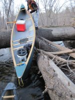
Boats down there and we're up here. "Tarazan" re-entry required.
PaxStrainers - 2.jpg


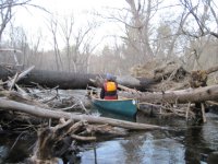
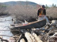
Most carries were off this variety. Run up on the log and pull over.
PaxStrainers - 3.jpg
 

Attachments

  • PaxStrainers - 3.jpg
    PaxStrainers - 3.jpg
    185.6 KB · Views: 0
No Title

One of my favorite local rivers is the Blackwater River which is very diverse. At 33 miles long I've run most of it. There's a narly class 4 section I'll never attempt. It has a dam about 3/4 of the ways down as well. One day we decided to run the section from Smith Bridge (might have been Peter's Bridge, I get the two confused) to the dam putting in at 5ish in the afternoon thinking we'd have no problem as dusk was around 830 and it was only 5 miles. Well, it turned out to be carry over after carry over no sneak routes under the river wide logs, I stopped counting at 19. My buddy kept counting and said we did 24. That's 24 in a short stretch of river. It was almost dark when we pulled off the river. I haven't been back on that section since and yes I was sore as heck the next day. Here's a few pictures from a different section as we didn't take pictures that day. It gives you and idea of what we played with!
 

Attachments

  • photo5713.jpg
    photo5713.jpg
    120.6 KB · Views: 0
  • photo5714.jpg
    photo5714.jpg
    132.6 KB · Views: 0
  • photo5715.jpg
    photo5715.jpg
    179.9 KB · Views: 0
We used to put in the Blackwater off Little Hill Rd when I was a kid but never saw a mess like that.

 
Sweeper, trying to picture a put in off of Little Hill. I know where that is. Was that above the dam? It's the only put in takeout I know of after Peter's Bridge. Not much between. Love the canoes!
 
I call those "pull-overs." In the north woods these are most often beaver dams, but in a river, those trees are pull overs to me.

Now when the boat is on the bottom of the shallows I call it it a drag. In both senses of the word!

A carry, or portage, means I empty the boat, pick it up, and move it to another point on the shoreline.
 
It wasn't much a road in, not very long and the last time I was in there was 1972.

​So looking at the map, I'd say it had to be somewhere near where the river straightens out below Warner Rd and comes close to the LH road
 
DougD, that is a tall pile to be pulling over. It's okay to sneak under, too--plenty of daylight under that log. I think we all select the route to take over, under, or around, based on what's easiest. I know we think of safety, too, but exactly how safe one can be while climbing through timber piles is questionable. As long as it all holds together and you don't slip, it's safe! Last week we encountered a strainer complex that was about 150' feet long, and we elected to go over, though there was an okay route to use around it. Once you get the boat up on the logs, it's not that hard to slide it. The hazard is on the paddlers, you really need to pick your way with care.

Jcav--I like your terminology, pull-overs and drags will now be my units of measure.

Dave, we put in on the Little Pax at Conways Rd. in Crofton. Nine pull-overs, two carries and three drags encountered between Conways Rd and the confluence. Only two pull-overs on the main Patuxent to the landing at Governors Bridge.
 
Would have slipped under if I could but the Courier has too much freeboard hence the climb! I agree with you that looking for the easiest route is best, on that day it was a lot of climbing and dragging of boats!
 
One day we decided to run the section from Smith Bridge (might have been Peter's Bridge, I get the two confused) to the dam putting in at 5ish in the afternoon thinking we'd have no problem as dusk was around 830 and it was only 5 miles. Well, it turned out to be carry over after carry over no sneak routes under the river wide logs, I stopped counting at 19. My buddy kept counting and said we did 24. That's 24 in a short stretch of river. It was almost dark when we pulled off the river. I haven't been back on that section since and yes I was sore as heck the next day. Here's a few pictures from a different section as we didn't take pictures that day. It gives you and idea of what we played with!

Back in the heyday of the Duckheads we would paddle the Pocomoke and tributaries every August over a 4 day Weekend of Rivers group trip.

Every few years we would paddle the upper Pocomoke, starting at Whiton Crossing. Or, egads, above Whiton. We knew those were likely to be strainerfests, and it took a couple of years passage of time to forget just how grueling 5 miles could be.

I expect Chip and Dave04 have paddled those sections, and the degree of difficulty varies from year to year and with water level.

We did the five miles between Whiton and Porter one low water year. In eleven hours. Or twelve, who’s counting.

There was every manner of obstacle. Speed bump logs. Dicey will-the-boat-fit duck under max-headroom logs. I stopped counting at 20+ haul the boat over complex log piles. That is a cypress swamp, so hauling the boat around obstructions on land isn’t much of an option, ‘cause there is not land, just a dauntingly thick expanse of cypress trees and knees. Fortunately it is flatwater, and was low flow to boot, so current and strainer issues were absent.

I had done a pre-launch group meeting, and explained that there would be a lot of strainers and that, with a dozen boats, we all didn’t need to, and timewise couldn’t all wait after every strainer. Get over/under/across, wait for the next boat or two to clear, get gone.

The allure of waiting for someone to eff up and falling off a log into the mud was too good to pass, so despite my attempts at chivying the group along everyone wanted to stay and watch at every obstacle.

And then there were the “speed bump” logs, cross river timber with a couple inches of water flowing over log. A couple of novice swampers on that trip just didn’t get it. I would bump over in demo and stage against the log on the downstream side, encouraging them as they approached, “Paddle, keep paddling, paddle hard, lean back, lean forward and you’re over”. This was somehow translated as “Paddle, oh god there’s a log, stop paddling, drift a third of the way over and sit there looking puzzled”.

Towards dark muscling the canoe over a strainer pile only to see the next towering occlusion only 20 paddlable yards downstream was, um, disheartening. I started swimming the boat between too close strainers.

We were not getting out of there before dark. And I know of two groups that spent the night in the Pocomoke swamp when darkness fell. Actually, three, two of them met up bivouacked swamp in the swamp. I was not going to be part of number four.

With less than a mile remaining and darkness falling to go I took off at a race pace and left them behind in the swamp.

I got to my truck shortly after nightfall, cleaned and bandaged up my bleeding parts, strapped a D-cell Maglite to the bow and went back for them. They still had a couple strainers to clear when I found them.

James Branch/Hitch Pond Branch below Trap Pond SP in Delaware is another classic swamp run. That section can have nice current when Trap Pond is spilling. It is less than 3 feet wide in places and S-turn twisty enough that a 17 foot canoe won’t make the turns before wedging between banks.

Cleared of strainers we have run that 5 mile stretch in under two delightful hours (during a spring skimmer hatch; like paddling through a cypress knee fairyland) and conversely taken an 8 hour body beating.

I love swamping. Especially if I have time to forget.
 
My favorite local river system is the Connowango/cassadega system in SW NY. There can be huge logjams on it, sometimes 50yds long. We keep track by length. Because the banks are steep and muddy and unclimbable, climbing over the jam dragging your canoe is the only possibility. Lots of fun, but not for everybody. The only real complication is when, on the upstream side, there is floating debris too thick to paddle through, but unable to support your weight.
Turtle
 
Back
Top