Day 1: May 19, 2021
Having loaded my canoe & gear the evening before, and rising at about 4:30am, I stole out of the house like a thief and set off from southeast Pennsylvania for an 8 hour drive to the Adirondack Park. This is a very familiar drive for me since I've been going to the Adirondacks for over 55 years now, since I was 13, though until recently strictly for the hiking & climbing in the High Peaks area. This trip marks my second time paddling in the SRCA, my first trip just last November. Also, this is only my second SOLO paddling trip anywhere! It seems with age creeping up on me, all my old friends are no longer able or interested in canoe tripping, and my son who has been on lots of adventures both on water and climbing/mountaineering now has three kids of his own. Much of his time now is devoted to his family and career, though he does have an active group of outdoor partners who regularly mountain bike, bike pack, and backcountry ski/snowboard- much of that also in the High Peaks of the ADKs.
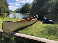
After an easy ride north in my comfortable old work truck, my lovely wood/canvas canoe and I arrived at Little Clear Pond, behind the New York State Fish Hatchery complex on Rt. 30. Little Clear Pond is roughly 12 miles west of the town of Saranac Lake, NY. Once at the launch site I signed into the register,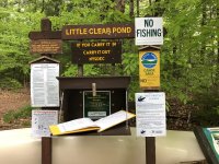 then dropped off my canoe and gear which I secured to the sign nearest to the actual shore launch.
 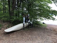 The plan then was to drive over to Hoel Pond and the launch site which would be my take out on Friday afternoon. Having left the truck, and carefully locked up and deposited my keys in a zippered pants pocket, I proceeded to walk back to the Little Clear Pond launch site. The better idea would have been to bring along a bike for the 3.5 mile journey, but I don't own any bikes which I would leave out in the woods once I launched my canoe! So... I walked on and it was a pleasant walk through the Saranac Inn golf course- I'll need to bring my clubs for a round of golf when I take out the next time, though with my lousy golf skills, I could probably play just as well using my paddle to knock the ball around. Walking out to Floodwood Rd I waved to a friendly NY State Trooper who was going the other way, then about 2 miles along my way, the same trooper stopped me on Rt. 30 and he asked me if all was well. Once I explained my plan, he offered me a ride the rest of the way! An unexpected treat!
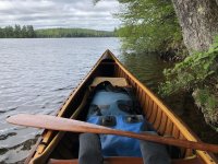
Launching onto Little Clear Pond I immediately encountered both black flies and a headwind. By now it was about 3:00pm, and beginning to rain a little. In the stiff wind, I headed for the lee of the shore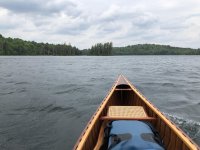 on the west side, and aimed for the small channel between the shore and an island, seen here just left of my bow (actually the stern, as I'm paddling backwards from the bow seat). Though requiring some brisk paddling, and judicious aiming just a few points off directly into the wind so I could paddle on the lee side of the canoe, thereby needing very few corrective strokes, I made it to the carry to St. Regis Pond.
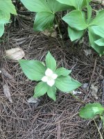
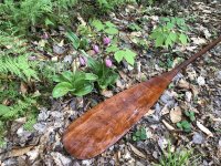
 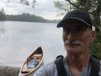 Since I had been here just last November, though paddling in the opposite direction, the landing and carry trail were quite familiar to me. Of particular interest were several Pink Lady Slippers https://www.fs.fed.us/wildflowers/pl...m_acaule.shtml
 The carry to St. Regis Pond was pleasant. Oddly, the bugs were absent in the woods perhaps because there was a consistent breeze and perhaps the light rain helped as well. Along the way, I encountered another fellow my age who was carrying his Hornbeck classic 12' canoe back from a day of fishing on St. Regis Pond. We spoke for a few minutes in which I apologized for stopping him while he had his canoe on his shoulders and he said he didn't mind a bit since his canoe was so light (19 lbs), as opposed to my 15 foot 62 lb canoe! While mildly envious, I still love paddling my canoe and at least as long as I can manage it, I get so much enjoyment from my w/c canoe that I'm willing to suffer a little carrying it.
This topic of carrying/portaging is of great interest to me now as I'm getting older. I used to have the mindset that I would just shoulder the load along with my pack and get it over with; in fact, that's just what I did last November.... single carrying my outfit on the long carry from Long Pond to Bessie Pond (about 1.5 miles). If you read my prior report, https://www.canoetripping.net/forums...morrow-morning, you may note that I made a comment about 'rushing through the trip'. I had decided that this time around I would not do that, and in particular, I decided to try to enjoy the carries more. To that end, I would carry the canoe along with a light pack as far as I could comfortably (is that possible?) manage, drop the canoe (gently, gently) and then go back for my main heavier pack. Then, I would carry the heavy pack beyond the canoe resting in the woods all the way to the next landing, and then go back to carry the canoe the rest of the way. This was a revelation for me; I thoroughly enjoyed the carries more, took more note of my surroundings, the flora and fauna, and generally didn't hurry. This has to become my new habit!
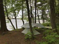
I leap-frogged the canoe and pack a couple of times, and finally arrived at the landing on the marshy inlet of St. Regis Pond.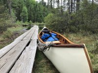 By now, it was getting near 5:00pm and I didn't have a clear idea of where I would camp on St. Regis Pond. All I knew was that I wanted a breezy spot to keep the bugs at bay! So, paddling roughly NW I headed for the first point of land on my right but nearing the site there I rounded the point and discovered a canoe pulled up onshore, and spotted a single guy already camped there, and not wanting to disturb his placid campsite I simply waved and carried on out into the larger lake. The wind was so fierce from the NW that I headed across open water for the small island due north of the point, aiming to get into the lee of the island and consult my map for the location of a suitable campsite. The island campsite is currently closed for regeneration, and I could see another party camped on the larger island to the east, so I continued NbyE to the far shore where I found site #8. It was most importantly open to the NW breeze which was good. Landing the canoe was somewhat difficult though as there is a steep bank to negotiate. Luckily, I tucked the canoe in between the shore and a floating log which at least gave me respite from the waves! I tossed my packs up onto the bank, then pulled the canoe over the grassy bank for a smooth and gentle ride to a safe spot onshore. After a long day, driving and paddling, my little campsite by the shore was a welcome spot! I quickly set up my one man tent, a tarp, and after a short nap in the bug free haven of my tent, I made a quick dinner of freeze dried Chili Mac and headed off to an early nights sleep serenaded by loons, barred owls, raindrops, and the occasional mosquito humming.
My camp, and the necessary headgear!
End of part 1; more to follow in a day or two!
Having loaded my canoe & gear the evening before, and rising at about 4:30am, I stole out of the house like a thief and set off from southeast Pennsylvania for an 8 hour drive to the Adirondack Park. This is a very familiar drive for me since I've been going to the Adirondacks for over 55 years now, since I was 13, though until recently strictly for the hiking & climbing in the High Peaks area. This trip marks my second time paddling in the SRCA, my first trip just last November. Also, this is only my second SOLO paddling trip anywhere! It seems with age creeping up on me, all my old friends are no longer able or interested in canoe tripping, and my son who has been on lots of adventures both on water and climbing/mountaineering now has three kids of his own. Much of his time now is devoted to his family and career, though he does have an active group of outdoor partners who regularly mountain bike, bike pack, and backcountry ski/snowboard- much of that also in the High Peaks of the ADKs.
After an easy ride north in my comfortable old work truck, my lovely wood/canvas canoe and I arrived at Little Clear Pond, behind the New York State Fish Hatchery complex on Rt. 30. Little Clear Pond is roughly 12 miles west of the town of Saranac Lake, NY. Once at the launch site I signed into the register,
 then dropped off my canoe and gear which I secured to the sign nearest to the actual shore launch.
  The plan then was to drive over to Hoel Pond and the launch site which would be my take out on Friday afternoon. Having left the truck, and carefully locked up and deposited my keys in a zippered pants pocket, I proceeded to walk back to the Little Clear Pond launch site. The better idea would have been to bring along a bike for the 3.5 mile journey, but I don't own any bikes which I would leave out in the woods once I launched my canoe! So... I walked on and it was a pleasant walk through the Saranac Inn golf course- I'll need to bring my clubs for a round of golf when I take out the next time, though with my lousy golf skills, I could probably play just as well using my paddle to knock the ball around. Walking out to Floodwood Rd I waved to a friendly NY State Trooper who was going the other way, then about 2 miles along my way, the same trooper stopped me on Rt. 30 and he asked me if all was well. Once I explained my plan, he offered me a ride the rest of the way! An unexpected treat!
Launching onto Little Clear Pond I immediately encountered both black flies and a headwind. By now it was about 3:00pm, and beginning to rain a little. In the stiff wind, I headed for the lee of the shore
 on the west side, and aimed for the small channel between the shore and an island, seen here just left of my bow (actually the stern, as I'm paddling backwards from the bow seat). Though requiring some brisk paddling, and judicious aiming just a few points off directly into the wind so I could paddle on the lee side of the canoe, thereby needing very few corrective strokes, I made it to the carry to St. Regis Pond.
  Since I had been here just last November, though paddling in the opposite direction, the landing and carry trail were quite familiar to me. Of particular interest were several Pink Lady Slippers https://www.fs.fed.us/wildflowers/pl...m_acaule.shtml
 The carry to St. Regis Pond was pleasant. Oddly, the bugs were absent in the woods perhaps because there was a consistent breeze and perhaps the light rain helped as well. Along the way, I encountered another fellow my age who was carrying his Hornbeck classic 12' canoe back from a day of fishing on St. Regis Pond. We spoke for a few minutes in which I apologized for stopping him while he had his canoe on his shoulders and he said he didn't mind a bit since his canoe was so light (19 lbs), as opposed to my 15 foot 62 lb canoe! While mildly envious, I still love paddling my canoe and at least as long as I can manage it, I get so much enjoyment from my w/c canoe that I'm willing to suffer a little carrying it.
This topic of carrying/portaging is of great interest to me now as I'm getting older. I used to have the mindset that I would just shoulder the load along with my pack and get it over with; in fact, that's just what I did last November.... single carrying my outfit on the long carry from Long Pond to Bessie Pond (about 1.5 miles). If you read my prior report, https://www.canoetripping.net/forums...morrow-morning, you may note that I made a comment about 'rushing through the trip'. I had decided that this time around I would not do that, and in particular, I decided to try to enjoy the carries more. To that end, I would carry the canoe along with a light pack as far as I could comfortably (is that possible?) manage, drop the canoe (gently, gently) and then go back for my main heavier pack. Then, I would carry the heavy pack beyond the canoe resting in the woods all the way to the next landing, and then go back to carry the canoe the rest of the way. This was a revelation for me; I thoroughly enjoyed the carries more, took more note of my surroundings, the flora and fauna, and generally didn't hurry. This has to become my new habit!
I leap-frogged the canoe and pack a couple of times, and finally arrived at the landing on the marshy inlet of St. Regis Pond.
 By now, it was getting near 5:00pm and I didn't have a clear idea of where I would camp on St. Regis Pond. All I knew was that I wanted a breezy spot to keep the bugs at bay! So, paddling roughly NW I headed for the first point of land on my right but nearing the site there I rounded the point and discovered a canoe pulled up onshore, and spotted a single guy already camped there, and not wanting to disturb his placid campsite I simply waved and carried on out into the larger lake. The wind was so fierce from the NW that I headed across open water for the small island due north of the point, aiming to get into the lee of the island and consult my map for the location of a suitable campsite. The island campsite is currently closed for regeneration, and I could see another party camped on the larger island to the east, so I continued NbyE to the far shore where I found site #8. It was most importantly open to the NW breeze which was good. Landing the canoe was somewhat difficult though as there is a steep bank to negotiate. Luckily, I tucked the canoe in between the shore and a floating log which at least gave me respite from the waves! I tossed my packs up onto the bank, then pulled the canoe over the grassy bank for a smooth and gentle ride to a safe spot onshore. After a long day, driving and paddling, my little campsite by the shore was a welcome spot! I quickly set up my one man tent, a tarp, and after a short nap in the bug free haven of my tent, I made a quick dinner of freeze dried Chili Mac and headed off to an early nights sleep serenaded by loons, barred owls, raindrops, and the occasional mosquito humming.
My camp, and the necessary headgear!


End of part 1; more to follow in a day or two!
Last edited:

