• Happy International Left-Handers Day! 🫲🏻

In defense of dams, which U.S. canoeists should worship!

Glenn MacGrady

Administrator
Staff member
Joined
Oct 24, 2012
Messages
6,986
Reaction score
14,548
Location
NW Connecticut
Dams have been unfairly and unwisely d*mned, including on this site.

Without dams, both the lentic and lotic canoeing waters of the USA would be impoverished.

Let's start with extreme lotic waters: whitewater rivers. Without dams, whitewater runs for normal paddlers would be limited to a narrow window between the gullywashing torrents of peak runoffs of spring and the bony rock gardens of summer and fall. Dam releases provide predictable and safe levels for whitewater canoeing throughout the year, all over the country.

The importance of dams for lake/lentic canoeing is even more dramatic. The only places in the USA that have a high percentage of natural lakes are the northern states that were glaciated during the last Ice Age and Florida. The rest of the USA's lentic canoeing waters rely on dams—from picturesque mill ponds, to swamps like Sparkleberry, to large lakes. In a 2012 assessment of 111,119 lakes in the USA, the U.S. Environmental Protection Agency estimated that 52% are natural and 48% are manmade.

Maryland has zero, zip, nada, no natural lakes. Texas has only one large natural lake. Delaware has at most two. Other than in the formerly glaciated northern tier of states and Florida, the vast majority of lakes in every state are manmade. DAM CREATIONS! Here is the EPA's distribution map of natural vs. manmade lakes in the USA's Lower 48:
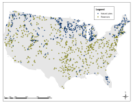
1786410471433.png

For lentic water paddlers who like to travel by bush plane, Alaska has about 3 million natural lakes. Hawaii has only five.

Virtually all the lakes and ponds I paddle in Connecticut are dammed.

For the dam busters among us (with all due respect to the RAF's Operation Chastise), remember that busting dams en masse will bust U.S. canoeing en masse.

Maybe that's why god invented Canada.
 
There are some undammed stretches of river that are canoeable most of the year, sometimes even in both directions. The Teton has no impoundment dams (well, we tried). I just got back from paddling some of the upper valley stretch, going upstream and down in late summer flows. I saw no evidence of high spring floods.

The Salmon (aka River of No Return) is navigable for the whitewater capable most of the year. The South Fork of the Payette runs all summer. Neither are controlled by dams.

Large natural lakes...we have four. Pend Oreille, Bear Lake, Coeur d'Alene, and Priest Lake.

Three others are of significant size (4,000 to 6,000 acres) - Henrys Lake, Payette Lake, and Hayden Lake.

Besides that, the Snake River below Shoshone Falls is largely spring fed year-round, to the tune of about 5'000 cfs.

There are numerous other rivers with upper reaches that are navigable (especially if you're a poler) all through summer in most years
That's just Idaho. I know there are some as well in neighboring states. I'm not sure how much I would really miss dams in the PNW..... assuming we made up the loss with nuclear power.
 
Last edited:
Florida has a lot of natural lakes and many of the spring fed rivers are not dammed. Fisheating Creek is not dammed but only because angry citizens objected. The further south you do, the more dams and other impediments impair water flow.
 
Coal, steel, grains, gravel/sand, and other heavy materials still move around central US on large rivers and these remain navigable for barges most of the year only because of dams and locks.

I once took a river trip on the Scioto and Ohio rivers. Many large tows of barges on the Ohio and the shore has many terminals to transfer to and from railroads or other land transport.

OTOH, the map above shows 2 natural lakes in Ohio while Wikipedia lists 13 natural lakes larger than 100 acres. Maybe different criteria for "natural"?
 
I’ve been thinking about this while reading the other conversation about removing dams. Lake Nockamixon is my regular day paddle, a 1450 acre lake created by a dam. Without that getting in the water around here would be a challenge, particularly as the summer progresses and local rivers get low. And I very much enjoy lake paddling.

While I recognize that dams have been generally not great from an environmental standpoint, I selfishly don’t want my local spot to go away. And it does seem like the conversation can be a bit more nuanced than “dam bad get rid of dam.”
 
Without the system of dams on the Boise, this Treasure Valley community wouldn't exist. Much of the farmland that is being swallowed up by development lies in what was historically the seasonal flood plain. That farmland itself would be too dry for any significant production if not for the system of diversions and canals. I don't see any chance that Boise River dam removal will even come up in discussion here any time soon, but it's a shame there was never any consideration for spawning fish.

That has been the disaster to the steelhead and salmon fisheries brought by the Snake River dam complex. There is much talk about removing the dams on the lower Snake. It's highly controversial, because of their utility as power producers and inland navigation. It's pretty doubtful that I will live to see any of that resolved.
 
I'm very lucky living in Ontario with it's 250,000 lakes (about 95% natural), but most of the larger rivers themselves have at least one dam. In the 60's through to the late 90's our MNR were fairly progressive though, and insisted new projects must have well-engineered fishways- many are "pool and drop", with large 1000+ gallon holding ponds (off grade septic tanks) between 18-24" drops, as they work with all water levels unlike the old "fish-ladders" that needed a substantial flow to get enough depth to function. Many old dams were retrofitted at the same time. One easy fix for smaller flood control dams was to cut a window or slot through it that still allowed fish access while holding water back, and in fact, many are intentionally designed to plug with debris in a high water flooding situation. An added bonus was that many of the invasives don't have the stamina to fight the high volumes of water flowing through those windows.
Unfortunately in the late 90's MNR budgets were slashed meaning less boots on the ground to ensure that the actual installations met the submitted drawings, resulting in a lot of rubber- stamped designs that just do not function.
Although it still means portaging, the maintenance paths for the runs make nice wide, gentle portages because of the need to get small, heavy equipment in to remove debris or maintain the structures, and many are now favorite spots for lunch breaks. it's not uncommon to see a half- dozen canoe carts chained to trees or hidden in the bushes. One dam operator went so far as to put in a rail to lock your cart to...
it's a strategy that works while only creating a minor inconvenience to all users without singling out only one of them, and I really wish more US states would adopt similar legislation- maybe it's time to demand change in HOW the dams operate rather than the existing go/ no go mindset...
 
Your post makes the assumption that canoeing is a top priority, making human recreation the prime reason for keeping dams. I know you’re a smart guy, and I expected something more nuanced from you. Do you really think we should keep all dams because they give us a place to recreate?
 
Your post makes the assumption that canoeing is a top priority, making human recreation the prime reason for keeping dams. I know you’re a smart guy, and I expected something more nuanced from you. Do you really think we should keep all dams because they give us a place to recreate?
Relax. It's just a point for discussion.

I don't think anyone here believes we should keep all dams for recreational purposes - or any other reason FTM. Personally, I see both sides of the issue. As much as I would love to see a resurgence of free flowing rivers, I also recognize that there is a price to pay in human life issues.....food production and safe housing, for instance. I think we all realize that.

I live 15 minutes from a large reservoir with two dams and 15 minutes from a dam controlled river. I'm 30 minutes from another dam controlled river, and an hour from another. As a paddler, I benefit from a lot of dams. Would I miss them if they were removed? I don't know. Certainly not if they had never existed.
 
There are some undammed stretches of river that are canoeable most of the year, sometimes even in both directions. The Teton has no impoundment dams (well, we tried). I just got back from paddling some of the upper valley stretch, going upstream and down in late summer flows. I saw no evidence of high spring floods.

The Salmon (aka River of No Return) is navigable for the whitewater capable most of the year. The South Fork of the Payette runs all summer. Neither are controlled by dams.

Large natural lakes...we have four. Pend Oreille, Bear Lake, Coeur d'Alene, and Priest Lake.

Three others are of significant size (4,000 to 6,000 acres) - Henrys Lake, Payette Lake, and Hayden Lake.

Besides that, the Snake River below Shoshone Falls is largely spring fed year-round, to the tune of about 5'000 cfs.

There are numerous other rivers with upper reaches that are navigable (especially if you're a poler) all through summer in most years
That's just Idaho. I know there are some as well in neighboring states. I'm not sure how much I would really miss dams in the PNW..... assuming we made up the loss with nuclear power.

Both Lake Pend Oreille and Lake Coeur d'Alene have dams built to raise the original lake level higher, provide hydropower. I can only speak to Lake Coeur d'Alene as live near it. That dam will never come out because of lake front property owners, the cities, possibly the tribe. Avista who controls the dam, pays mitigation fees to the tribes for flooded land is my understanding.
It’s not just dams. It’s groundwater withdrawal. Last summer, the Spokane river went dry for a mile or so. Second time in current decade. The influx of people has lowered the water table that replenished the river in the summer. Any springs now, are further downstream. I was talking to an old boy one day at the river. He mentioned how theres very few red band trout, doesn’t understand it. Saying as a boy, they used to catch 30-40 trout every weekend right there….. huh, over fishing, less water
 
Throughout the Adirondacks, we have multiple dams and remnants of dams, but an odd treatment of them.
Some of these dams are within designated wilderness areas, which, according to the Adirondack Park Agency Master Plan, are to have NO man made structures. In fact, existing man made structures are actively removed when NYS takes ownership and designates the area Wilderness. ( For example, when NYS acquired Lake Lila and designated it Wilderness, the DEC burned and removed all of the structures from the great camp Nehasane.) This edict is enforced by NYS Department of Environmental Conservation (DEC)...sort of.
Some of the dams within designated wilderness areas were actively maintained by the DEC. The dam on Duck Hole is (was) an example. The DEC struggled to maintain it for years until it was taken out by the remnants of hurricane Irene. And Duck Hole, a nearly sacred place, became Muck Hole.
A dam on Cedar Lakes has been intentionally left to decay. The series of linked lakes are continually shrinking, eventually to become a much smaller lake and associated wetlands.
I paddled and carried in to both of those waterbodies and they were spectacular...
The dam on Henderson Lake, yes, holding back the Hudson River is in a designated wilderness area. Yet the dam remains and is actively maintained.

There was a dam on the Boreas River, Lester Dam, that was breached by stormwaters in the 70's. While this dam was in a designated Wild Forest and could have been repaired, it was not. I paddled Cheney Pond and Lester Flow before and after the breach, as well as the Boreas downstream from the former dam. I preferred the dammed section of the Boreas.

While I appreciate the paddling opportunities that these dams provide(d), I question the inconsistent enforcement of allowing some man made structures not only remain, but have efforts to maintain them, while other MUST be removed since they are non conforming structures.

Go figure...
 
Both Lake Pend Oreille and Lake Coeur d'Alene have dams built to raise the original lake level higher, provide hydropower.
Yes, but we're talking about only an additional what - twelve feet? And a very small fraction of additional acreage. Without the dams, they're still very large natural lakes, and Pend Oreille still being over 1100' deep. You can include Bear Lake in that as well.
 
Yes, but we're talking about only an additional what - twelve feet? And a very small fraction of additional acreage. Without the dams, they're still very large natural lakes, and Pend Oreille still being over 1100' deep. You can include Bear Lake in that as well.

Lake Pend Oreille is 90’ tall dam.
Lake Coeur d'Alene Dam is 31’.

Yes, natural lakes, dam controlled.
 
Here is the EPA's distribution map of natural vs. manmade lakes in the USA's Lower 48:
What's the threshold in acreage for the EPA to consider a waterbody a lake? Reason I ask is that there are hundreds of lakes within the lower 48 missing from that map if the lakes shown within Vermont are representative.

As to the value of reservoirs, I agree, I'd hate to see every dam removed simply (and I use that term somewhat facetiously) to restore stream reaches or wetlands. Tradeoffs are inevitable when considering our effect on the world. I selfishly use many reservoirs for canoeing and have to say that some of the best places to canoe are reservoirs. As mentioned in this thread, there are numerous other benefits from dams and the reservoirs they create, despite the inherent drawbacks. It's a balancing act and many dams should be removed, but how do we decide which ones?

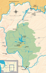
One of the more dramatic benefit/cost examples is Lake Roosevelt behind Grand Coulee Dam. Although disastrous for anadromous fisheries upstream, Grand Coulee Dam has a total generating capacity of 6,809 megawatts and its average annual energy output is about 2,300 megawatts, the largest power station in the USA. That's enough power to continuously supply the needs of two cities the size of Seattle (or a hundred small towns and cities) and perhaps more importantly, supplies irrigation water to over 670,000 acres of some of the most productive farm and orchard land in the USA.

The Columbia Basin Project is an ingenious (and massive) irrigation system that takes advantage of a natural coulee, Banks Lake *, to store water pumped up from Grand Coulee Dam and distribute irrigation water through a system of canals. Potholes Reservoir captures return flows from the northern half of the project to store and redistribute water to the southern half of the project. The amount of irrigation water, 2.3 to 2.7 million acre-feet of water (800 billion gallons!), is just over two percent of the Columbia River's average annual flow and isn't depleting stream flow or aquifers like most of the other major irrigation systems in the USA. Do the benefits to society outweigh the loss of salmon, steelhead and bull trout runs above Grand Coulee Dam? In this case, I think they do, even though Lake Roosevelt isn't all that great for canoeing. :unsure:

* Banks Lake offers some prime canoeing at the northern end of the reservoir. Just be aware of the 20 mile wind tunnel fetch if the wind is coming from the south.

1786544193547.png
Note: The green shading represents the entire Columbia Basin Project area; irrigated acreage is distributed throughout.
 
Last edited:
Look folks it’s been nearly 3 days this thread has been up, and we’re missing the bigger picture. If y’all don’t start taking advantage of this opportunity with some more dam puns I’m going to quit checking in on it. Let’s lock in here, and take this to another level.
 
So this morning I'm thinking about the reservoirs I visit the most - those within an hour from home.

The closest was created as a shallow irrigation impoundment, holding water diverted from the Boise River. It was given a second purpose after its creation, as a wildlife preserve. It now supports a large population of Western grebes during nesting season, serves as a stopover for migrating waterfowl, and a summer home for various other bird species. I go there often to view the heron rookery from my canoe, as I find the fledglings most entertaining.

That lake also has a good population of bass and now walleye (which were illegally introduced, which is kind of ironic), and I sometimes do fish for them. But there's a pretty short window of time that I will use that lake. Boating is essentially prohibited between September 30 and April 15. From about the end of July until about the beginning of September, algae blooms often render the water unhealthy. So I'm limited to about four and a half months of canoeing there.

During that time though, the powers that be have decided that jet skis and wake boats somehow comply with the mission of the preserve (contrary to the mission statement, IMO), so my involvement is mostly restricted to the fringes while the pool is high and into the surrounding vegitation. Since irrigation takes water out faster than it comes in, that has me usually abandoning the lake by late July, if not sooner. I will admit that I'm allowed to paddle in the "no boating" season, so long as I stay within 200 yds of the dam. So I can go there for boring exercise without driving the additional 15 minutes for the more interesting Snake River.

So as a purely selfish canoeist, I wouldn't miss that lake much if the dams (there are two) were removed.

Next closest is an aged impoundment on the lower Payette that is so silted in that it isn't much more than a large pond and a diversion. In fact, the river coming into it would be more fun and more navigable if it ran free instead of filling with sand bars. I don't actually paddle in the lake itself....ever. It's just the take out spot for the river above. The selfish canoer in me would like to see that dam gone, but the diverted flow waters a valley that produces a lot of fruit and other agriculture. OTOH, it serves virtually no flood control purpose, unlike the dams upstream.

About the same distance in another direction is Lucky Peak. This lake is pretty much nothing but a mass of powerboats and clapotis - when the wind isn't blowing up or down the narrow canyon. I rarely go there. This is the one that, with the help of the two above it, waters pretty much the whole Treasure Valley. Can't say it does anything for my canoeing.

The one directly above that is a little sketchy to access in the busy season, but much more usable in a canoe. A couple years ago, it was almost completely empty at summer's end. The river that was left was quite runnable and would have been even without the upper dams. Again, better for canoes without the dams IMO, but a major part of the valley water supply in the heat of summer.

The three Boise River dams do provide flood control. Without them, the lower Boise would be largely unrunnable during spring and often well into early summer. The upper reaches and tributaries however have plenty of early season opportunity, much of that going well into summer. The late summer flow going into the system would be more than enough for good canoeing, were it not diverted to farms - and especially if it retained its natural meandering in the valley.

Back again to the Snake...
A little bit upstream from me is the oldest dam on the Snake. The Swan Falls dam was built in 1901 to provide power to the Silver City mining district in the nearby Owyhee mountains. Without checking, I can't say what spring runoff was like at the time, but that's not a high dam, so it couldn't have been very dramatic. What I do know is that I have run the river below that dam during a heavy spring release when all the reservoirs above were about full and the BOR was making room for more, and it was a gas. The river is consistently runnable for many miles below that, year round. And if it wasn't being drawn off for irrigation, it would never be below that spring fed 5,000 cfs.

So as a purely selfish canoeist, I think I would have been happy if these dams were never built. That's fine as a mental exercise, but of course it's not the reality we live in. Bottom line, we have to face the fact that our presence has resulted in great damage to the environment, and we should be making effort to reverse that where we reasonably can.

And at that, @ABT , I will end this long dam post.
 
Last edited:
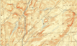
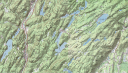
In Harriman State Park (NY), many lakes were created by damming small streams, none of them navigable AFAIK, to create lakes for recreational purposes (and a few reservoirs). This is what it looked like in 1893:

1786623486980.png

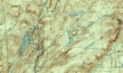
In 1910, it looked much the same but there were more houses:

1786623609319.png

The Park was created in the nineteen-teens and the lakes were created and given pseudo-Indian names. The mountain people were displaced and the place where one town was (Sandyfield) is now under water, but that's another story.

Then the Park invited local groups and clubs to build camps on the lakes, some for children and some for families. My great grandfather was one of the founders of one of the three family camps which still exist and where I grew up, and the American Canoe Association has a camp on Lake Sebago. The lake where I do most of my paddling started as a small natural lake (Little Long Pond).

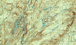
In 1918, a 20' high dam was constructed on Stillwater Creek which enlarged Little Long Pond and created the other two Kanawauke lakes. A larger dam on Stony Brook created Lake Sebago. This is what it looked like in 1938:

1786623793967.png

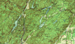
During the 1930 more dams and camps and roads were built, many with CCC labor. The residents of Sandyfield lost their long court battle and Lake Welch was created, with a large public swimming area and campground. Today it looks like this:

1786625769748.png

In the sixty years I've been paddling on the lake I've seen its character change. The coves that used to be paddleable are now silted up and choked with lily pads and invasive milfoil is everywhere. The water, though still very clean, isn't quite as clean as it was. Lake Welch, which was never very clean to begin with, is now plagued by recurrent algae blooms which have closed the lake for swimming and even fishing.

If the Park and lakes hadn't been created? Hard to say. Some of the descendants of the Sandyfield residents are still bitter, but the park is beautiful, in an area that would have been overrun by civilization. They certainly created paddling opportunities (and hiking and swimming and camping) where today there would certainly be larger towns and streams altered in other ways.
 

Attachments

  • 1786624216237.png
    1786624216237.png
    1.5 MB · Views: 1
The Penobscot River Restoration Trust removed three dams, opened a thousand miles of Salmon habitat, increased the hydropower capacity, all the while creating an incredible whitewater run from Old Town to Brewer. This is the same route that Chief Bashabez took to meet Samuel de Champlain in Penobscot Bay in the 1600's.

The Kennebec River Restoration Trust is forming to remove 4 dams on the Kennebec, restoring Salmon habitat on Sandy River, and restoring a large section of Benedict Arnold's route taken for America's failed attack on Quebec.

I raised $3,000 for the Penobscot River restoration by poling 180 miles up it to the furthest north point of Salmon habitat and will be starting a similar fundraiser next summer for the Kennebec project.

I am not in the camp of "All dams are bad", but the dam removal projects I am involved in are a net positive.
 
the map above shows 2 natural lakes in Ohio while Wikipedia lists 13 natural lakes larger than 100 acres. Maybe different criteria for "natural"?

What's the threshold in acreage for the EPA to consider a waterbody a lake? Reason I ask is that there are hundreds of lakes within the lower 48 missing from that map if the lakes shown within Vermont are representative.

I can't be sure and didn't count the dots, but I doubt the blue and yellow dots on the EPA natural lake/reservoir distribution map are attempting to show all 111,119 lakes sampled. It's more likely just a graphic summary. Here is what the text of the report says, which seems to indicate that the EPA sampled lakes smaller than 10 acres:

"Based on the NLA 2012, of the total 111,119 lakes assessed, approximately 52% (58,700) were natural and 48% (53,119) were manmade. The NLA found that natural lakes are distributed fairly evenly in size from small to large while most manmade reservoirs are relatively small. For example, 40% of reservoirs are less than 10 acres (4 hectares) compared to 22% of lakes."
 
Back
Top Bottom