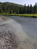
Day 3 finds us again floating casually down the Delta, it widens out, slows down, more flatwater than quickwater, as if it were impounded. In actuality it is. Eureka Creek, a glacial river, enters on river left, and the outwash delta pushes the Delta far up against the bluff on river right, impounding the flow. This photo shows where the very first glacial water from Eureka Creek filters through the outwash delta and enters the Delta River.

For those who have never paddled a glacial river, suffice to say, they are different. Very. The nature of the Delta changes completely as more and more of Eureka Creek enters. It becomes gray and absolutely loaded with sediment, viscous. The gradient steepens, volume quadruples, current speeds up, I'd estimate it clips along at 4-5 knots. The eddy lines get dramatic and squirrely, the standing waves build, the cut banks become filled with sweepers of downed spruce and alders. Altogether a different river. I would have been very anxious on the glacial section if they had broken that boat and we had all piled into the remaining boats. While the upper Delta is relatively benign, a swim on the glacial Delta risks consequences. Being glacial the water is cold, icy, and the dry suits were welcomed.

There are rewards though, as the valley opens up with stunning views of The Alaska Range above the Richardson Highway.

In this view, nearing the takeout, you can just about see the Trans Alaska Pipeline cutting across the hills. It actually tunnels under the river between here and the takeout.

At the takeout the Delta is thoroughly braided out, the river bed half a mile wide with half a dozen braided channels. We had to find just the right side channel and then line/drag our boats 1/4 mile to get to the cars. Once again a unique but quite common feature/event on a braided glacial river.

The takeout sign is just barely visible through binoculars from across the braided channels. It is possible to continue down the Delta for many more miles, through some seriously big water and the class IV Black Rapids. Not for us. I'd do it in a raft but would not consider it in an open canoe.

We parked the shuttle vehicle some miles down from the takeout at the Black Rapids Road House. There had been a rash of trailhead break-ins in Anchorage and, while we were not in Anchorage any more, we were still spooked. This is the original log Road House, being slowly restored. There is a gorgeous new Black Rapids lodge up the hill with slate siding. Now, I'm from New England and know slate roofs, but, have you ever seen a three story building with slate siding? The Black Rapids Lodge was extremely accommodating of our request to park there and provided some cold libations to wrap up the trip. Definitely deserves your patronage.

A gratuitous photo of the crew and shuttle rig, with three canoes clamshelled on top for the 60 mile drive back to the put in.

I took the scenic route home, some 120 miles of gravel across the Denali Highway. Truly not to be missed. There is a young man who traps out of his family's Alpine Creek Lodge and I heartily endorse a stay there if you've got the time. They cater to folks year round, though the road is not plowed in the winter and requires a 60 mile snow machine ride in from the nearest pavement. They will take you fishing for grayling, photographing moose, caribou and wolves, panning for gold, or even a ride along on his trap line. Real Alaskans for sure.

Me and my shuttle rig at the Windy Creek crossing at the entrance to the Clearwater Controlled Use Hunting Area. I've done a fatbike supported caribou hunt back up there in the Clearwater Mountains, but that, my friend, is a topic for another post in a different forum.

Keep the open side up,
Monel

For those who have never paddled a glacial river, suffice to say, they are different. Very. The nature of the Delta changes completely as more and more of Eureka Creek enters. It becomes gray and absolutely loaded with sediment, viscous. The gradient steepens, volume quadruples, current speeds up, I'd estimate it clips along at 4-5 knots. The eddy lines get dramatic and squirrely, the standing waves build, the cut banks become filled with sweepers of downed spruce and alders. Altogether a different river. I would have been very anxious on the glacial section if they had broken that boat and we had all piled into the remaining boats. While the upper Delta is relatively benign, a swim on the glacial Delta risks consequences. Being glacial the water is cold, icy, and the dry suits were welcomed.
There are rewards though, as the valley opens up with stunning views of The Alaska Range above the Richardson Highway.
In this view, nearing the takeout, you can just about see the Trans Alaska Pipeline cutting across the hills. It actually tunnels under the river between here and the takeout.
At the takeout the Delta is thoroughly braided out, the river bed half a mile wide with half a dozen braided channels. We had to find just the right side channel and then line/drag our boats 1/4 mile to get to the cars. Once again a unique but quite common feature/event on a braided glacial river.
The takeout sign is just barely visible through binoculars from across the braided channels. It is possible to continue down the Delta for many more miles, through some seriously big water and the class IV Black Rapids. Not for us. I'd do it in a raft but would not consider it in an open canoe.
We parked the shuttle vehicle some miles down from the takeout at the Black Rapids Road House. There had been a rash of trailhead break-ins in Anchorage and, while we were not in Anchorage any more, we were still spooked. This is the original log Road House, being slowly restored. There is a gorgeous new Black Rapids lodge up the hill with slate siding. Now, I'm from New England and know slate roofs, but, have you ever seen a three story building with slate siding? The Black Rapids Lodge was extremely accommodating of our request to park there and provided some cold libations to wrap up the trip. Definitely deserves your patronage.
A gratuitous photo of the crew and shuttle rig, with three canoes clamshelled on top for the 60 mile drive back to the put in.
I took the scenic route home, some 120 miles of gravel across the Denali Highway. Truly not to be missed. There is a young man who traps out of his family's Alpine Creek Lodge and I heartily endorse a stay there if you've got the time. They cater to folks year round, though the road is not plowed in the winter and requires a 60 mile snow machine ride in from the nearest pavement. They will take you fishing for grayling, photographing moose, caribou and wolves, panning for gold, or even a ride along on his trap line. Real Alaskans for sure.
Me and my shuttle rig at the Windy Creek crossing at the entrance to the Clearwater Controlled Use Hunting Area. I've done a fatbike supported caribou hunt back up there in the Clearwater Mountains, but that, my friend, is a topic for another post in a different forum.
Keep the open side up,
Monel
Attachments
Last edited: