I am heading out soon (about 24 hours) for my Summer solo trip, expecting to be on the water for about 3 weeks.
As you may know I have a preference for river trips where the current does some of the work and the excitement level is greater than it is for flat water trips. That said, in recent years I have done some lake or mostly lake trips and they are not that bad after all.
This year I'm heading to the "big crater", since that might not mean much I will provide some details.
The Manicouagan Reservoir which is located in eastern Quebec is in the remnants of a massive meteor strike about 200 million years ago which eventually created two large crescent shaped lakes. In late 1960's Quebec Hydro constructed the Manic-5 (Daniel-Johnson) Dam (one of the largest dams in the world) creating the reservoir by joining those two crescent lakes.

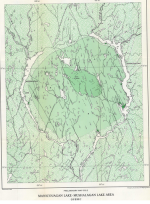
Prior to the dam it looked like this

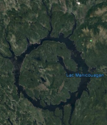
What it looks like now

I will be paddling around the huge island in the middle a distance of close to 200km.
There is a lot of online info about the reservoir, much of it related to the geology of the area with only a little info about paddling. What few reports there are talk about paddling in kayaks, many comment on it's unsuitability for open canoes due to the potential for bad weather (wind) that can make it dangerous. Other comments are about the swarms of bugs and freezing temperatures even in mid-summer. The bugs I can deal with, the cold is not a problem, the wind on the other hand is a concern especially when crossing the open water to get to and from the centre island. The area is frequently subject to storms appearing out of nowhere.
Although I could normally easily cover the distance in 10 days or less I expect to be wind bound at least half the time so I am prepared to take about three weeks to complete. If the conditions permit, I will add to the distance by exploring some of the rivers that flow into the northern part and the big bay that cuts into the centre island where Mont Babel towers 2000 feet above the level of the water. I have driven past the reservoir several times on my way to Labrador for previous trips, the scenery can be spectacular when it's not obscured by cloud or fog. There are many areas with cliffs as much as 800 feet high along the shore of the island (the outer shore line is more "flat" than the island). I plan to get over to the island and spend most of my time paddling close to the shore to avoid windy conditions as much as possible. Of course being a circle the best I can hope for is that I luck out and don't end up battling headwinds all the time. I'm not sure if I will paddle clockwise or counter clockwise, I will probably just pick whichever way seems best on the first or second day.
You can follow my progress on my tracking page: https://share.garmin.com/Grumpy
I will try to post update messages every day or two via my InReach satellite communicator, I can also receive weather information via InReach, hopefully that will tell me if it's a good day to paddle or best to stay in camp and wait for better conditions. I usually don't mind a layover day but it can get tedious if I get stuck for more than one day especially when conditions make wandering around on land unpleasant forcing me to stay cooped up in my tent.
I want to be back home in time to watch most of the "action" from the Paris Olympics, pretty sure I'll be too late for the opening ceremonies but in time to see most of events that I'm actually interested in.
As you may know I have a preference for river trips where the current does some of the work and the excitement level is greater than it is for flat water trips. That said, in recent years I have done some lake or mostly lake trips and they are not that bad after all.
This year I'm heading to the "big crater", since that might not mean much I will provide some details.
The Manicouagan Reservoir which is located in eastern Quebec is in the remnants of a massive meteor strike about 200 million years ago which eventually created two large crescent shaped lakes. In late 1960's Quebec Hydro constructed the Manic-5 (Daniel-Johnson) Dam (one of the largest dams in the world) creating the reservoir by joining those two crescent lakes.

Prior to the dam it looked like this

What it looks like now

I will be paddling around the huge island in the middle a distance of close to 200km.
There is a lot of online info about the reservoir, much of it related to the geology of the area with only a little info about paddling. What few reports there are talk about paddling in kayaks, many comment on it's unsuitability for open canoes due to the potential for bad weather (wind) that can make it dangerous. Other comments are about the swarms of bugs and freezing temperatures even in mid-summer. The bugs I can deal with, the cold is not a problem, the wind on the other hand is a concern especially when crossing the open water to get to and from the centre island. The area is frequently subject to storms appearing out of nowhere.
Although I could normally easily cover the distance in 10 days or less I expect to be wind bound at least half the time so I am prepared to take about three weeks to complete. If the conditions permit, I will add to the distance by exploring some of the rivers that flow into the northern part and the big bay that cuts into the centre island where Mont Babel towers 2000 feet above the level of the water. I have driven past the reservoir several times on my way to Labrador for previous trips, the scenery can be spectacular when it's not obscured by cloud or fog. There are many areas with cliffs as much as 800 feet high along the shore of the island (the outer shore line is more "flat" than the island). I plan to get over to the island and spend most of my time paddling close to the shore to avoid windy conditions as much as possible. Of course being a circle the best I can hope for is that I luck out and don't end up battling headwinds all the time. I'm not sure if I will paddle clockwise or counter clockwise, I will probably just pick whichever way seems best on the first or second day.
You can follow my progress on my tracking page: https://share.garmin.com/Grumpy
I will try to post update messages every day or two via my InReach satellite communicator, I can also receive weather information via InReach, hopefully that will tell me if it's a good day to paddle or best to stay in camp and wait for better conditions. I usually don't mind a layover day but it can get tedious if I get stuck for more than one day especially when conditions make wandering around on land unpleasant forcing me to stay cooped up in my tent.
I want to be back home in time to watch most of the "action" from the Paris Olympics, pretty sure I'll be too late for the opening ceremonies but in time to see most of events that I'm actually interested in.
