This year Kate and I returned to the Pickle Lake area for our June canoe trip. After last years trip, I assumed that there was never a rainy day around Pickle lake. Our weather was worst this year, as were the bugs. We drove to Pickle lake the day before, and stayed at the lakeview manor B&B, as we had the year before. Lynn took care of our vehicle shuttle.
We set off early on our first day, hoping to get ahead of the wind. We were not so lucky and made our way down the lake in a light rain and a heavy wind. The wind was better once the lake jogged west, but still required our full attention. The lake itself was scenic and full of rock outcroppings.
At 11:30 we came to a large section of lake that we could not safely cross in the wind. Luckly there was a nice place to camp. We warmed ourselves in our tent and killed time till dinner. No photos were taken the first day.
Day two we woke up at 4am. The wind was already strong. We were able to make our first crossing and head down the lake. The waves were very large, but the spacing between them was large and predictable. Around 11 we again came to s crossing that we were not comfortable with considering the wind. We decided to make our way into the bay and see if we could portage across the beginning of a large peninsula. The topo had it marked as a wooded bog, so it seemed possible. Portaging wasn't too bad, and it was nice to stretch our legs anyways. After our trip was over, I was amused to see a possible portage marked in the Canoe Atlas of the Little North.
After portaging, the wind seemed to die down, and the sun came out. We ate a nice long lunch on a sand beach. We continued down the lake, still in large waves, but in better spirits due to the sun. We made camp on a large rock outcropping right before the lake jogs south.


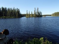
 Day three we again woke at 4am and paddled a large crossing. Once we begin heading west, we were treated t a light wind at our backs. We stopped after a few hours and ate breakfast on an island. The day was pleasant by the time we reached Johnston Bay. It took us a second to locate the entrance of the Cat river, but we were happy to be able to paddle right up the small swift at the mouth. We ere greated by the "Whale Rocks" referred to in the canoe atlas. By Blackstone lake there was on and off again light rain. The lake was very scenic, possibly my favorite of the trip. We met a party of motor boats from the fly in camp on the lake, and shortly after set up camp on a very small site.

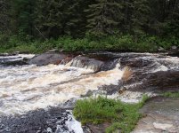
Day four saw us get off Blackstone and do our first planned portage of the trip. We were encouraged to find the port in good shape. The rapids we carried around were full of water. At the next portage it got a little tricky. The portage was marked on an island, but we were unable to find it. The island was very narrow, and there just weren't too many places the trail could have been hiding. The portage was around a series of rapids (we were heading upstream) and we were able to crash through the woods to the top of one set and paddle to the bottom of the other. another trip through the woods saw us at the top of the next set looking to the third, which was around a separate small island. Some hard paddling put us on the small island, and we lined up the rapids and ate lunch. On our way to Roadhouse lake, and then Bamaji we encountered a few more rapids, which may or may not have had portages around them, I can't remember. The important part is we got up them.
By the time we where to Bamaji the wind had really picked up out of the east. We headed N.W. across Bamaji sheltered by islands, until the time came to make a wide open crossing straight west. We made a poor choice and had a wild ride, but safely made it to the opposite shore. We paddled by a large fly in camp to a sheltered bay and made camp on a high rock. Soon after it started to rain heavily.


The morning of day five it was still raining. We made breakfast under the tarp and headed out. The wind was strong out of the west, and made our crossing of N. Bamaji difficult. I found the south shore of N. Bamaji very scenic. As we paddled across the lake, a float plane headed to the slate falls community landed right over us.
We were happy to find the first portage out of N. Bamaji. Once again, it was around a very full set of rapids. The next set of rapids was marked SLW, but we had to portage. Luckily there was an alright path. The last marked portage before Wesleyan lake may have existed, but the rapids seemed to be washed out, and some hard paddling got us to the top.
Wesleyan was again a very scenic lake, with high rocks and islands. The going was slow against a strong wind. On the north shore we could see the run out of what must have been a very large rapids, but we just didn't have it in us to fight the wind and go look at it.
We arrived at the portage between Wesleyan and Kezik, known as the "Cat River Portage" and shown on my topo map. The portage had a lattice of logs constructed on it for dragging boats. It made walking much more difficult.
On kezik we had a favorable wind. We ate lunch and than headed east for the first time. Kezik was a sprawling lake full of islands and narrow channels. We paddled in a light mist.
We came to the east end of Kezik a bit early to make camp. Our next section consisted of a very small creek, and I was unsure if we would be able to find a nice place to camp. We considered stopping early, but Kate leaned towards pushing on, so we did. The creek turned out to be one of my favorite parts of the trip. While I had though it might be swampy, it was generally it was high sided with small rock outcroppings. Paddling was easy, and a nice change of pace from the large lakes we'd been on. After around an hour we came to a great camp site on a small lake, next to a ledge filled rapids. A moose swam across the lake in front of us as we inspected the side. As the evening went on we were treated to our fist patch of blue sky since our second day.


Day six was our last day of going up stream. We broke camp and made our way up the creek, which was becoming narrower. The 350 m potage into the last lake on the creek was easy to find and in good shape, which was an encouraging sign for the long portages to come.
It took us a couple of passes to find to first of three long portages crossing the height of land into the Dobie river. Once on it, the 700m portage was flagged with a good trail, until we hit a swamp were it disappeared. After much dragging, cursing, and despair, we made it out to a small channel with took us to the next lake. The next portage, 800m, was high and dry and marked with old blazes. The last portage, marked 500m, was not apparent. With a little scouting we were able to carry through a section of spruce forest and emerge at Dorothy Lake. On Dorothy we saw flagging at a likely spot to have replaced the missing 500m port, and wondered if maybe our information was out of date (we were not using the route to the Dobie shown in the canoe atlas, but instead a route apparently used by Camp Wabun).
We crossed Dorothy lake and finally were on the Dobie. The Dobie is small at this point, but with steady current. We ran some small riffles and had to lift over a log. Shortly after passing the Winter Rd we came to a large drop that we lined. We portaged river left around a long rapids well on its way to becoming a log jam. We made camp just above a small lake at a nice but unspectacular site.


On day seven we woke up to blue skies. It would be our first full day of good weather. We paddled across the small unnamed lake and the made our way down a long shallow set of rapids, often wading. On the next lake paddled east into a strong wind. We took a 750m portage into Dobie lake. The port was in great shape, probably maintained by the fly in camp on the lake. We paddled Dobie, and ate lunch half way down on an island. We ran two sets of rapids, one large that required some eddy scouting, and one straight forward set. We paddled a small lake, and then Hergott Lake. After Hergott we found a small are we could camp at. We decided to paddle another little ways and see if there was better camping at the next portage. I had the portage on the left, but we eventually found it on the right. The rapids were impressive, but there was no good place to camp. We returned to the first site and made camp.

Day eight started with a short paddle and the portage we had found the day before. We padded until another large rapids which we ran left. We took on some water at a small ledge. As we paddled across Lecky lake, the and shifted to behind us. We ran a few easy riffles and ended up in Nanos lake, were the wind was no longer favorable. We ate lunch at Nanos. After Nanos we ran a couple SLWs and took a 600m portage around a powerful set of rapids. We ran a few more bigger rapids, eddy scouting on the way down. We came to a rapids that Lynn had told us to be cautious of, where the Dobie makes a hairpin turn during a steep drop. We ran the top, working form eddy to eddy. After awhile we found a portage trail in an eddy. Below us we noticed a slopping rock campsite, with small eddy above it. We elected to potage to it, since missing the eddy would have been high consequence. The site needed a little work, but sat at the edge of a massive section of the rapids. The water was deafening.


Day nine started with a long portage around the remaining rapids. It had rained all night, and the bugs were very bad. the remaining rapids on the Dobie were mostly easy straight shots. We entered the Otoskwin below Froats lake. Since we had paddled this stretch last year, it was interesting to compare water levels. The rapids this year seemed pushier and more confused. It rained most of the day. We were happy to take the long portage around the rapids above Bow lake, just to stretch our legs. Last year we had run and lined them, and I'm glad we did as there was no good view of the rapids or the campsite at their bottom from the portage.
We paddled Bow lake and them made camp on the portage around a big set of rapids. Last year we had arraived at this site mid-day and thought how nice it would be to camp there, so it was nice it worked out this trip. I rained on and off through out the evening, and the bugs keep us inside our bug shelter.


Day ten was a beautiful sunny day. We ran the bottom of the rapid we were camped on, and continued towards mud lake. The current was strong, and we made good time. We arrived at our last campsite from last year around 11:30. We new that it would take nearly a half day to make it to our take out, so we decided to camp and have a short day our last day. The bugs were bad, but a breeze kept them in check.


On day eleven it was overcast, but not raining. We paddled the last of the Otoskwin to Mud lake and made it to the take out. We drove about halfway home, and stopped in Upsala for the night.
This trip presented many challenges, from Lake St Joe to missing portages to unbelievable bugs and hard rapids, but on day eleven I would have happily just kept going down the Otoskwin. We paddled a little bit of everything, giant lakes to tiny creeks, and saw a pronounced difference in the landscape after crossing the height of land. The total trip ended up at 11 days and about 210 miles, plus around 16 hours driving.
We set off early on our first day, hoping to get ahead of the wind. We were not so lucky and made our way down the lake in a light rain and a heavy wind. The wind was better once the lake jogged west, but still required our full attention. The lake itself was scenic and full of rock outcroppings.
At 11:30 we came to a large section of lake that we could not safely cross in the wind. Luckly there was a nice place to camp. We warmed ourselves in our tent and killed time till dinner. No photos were taken the first day.
Day two we woke up at 4am. The wind was already strong. We were able to make our first crossing and head down the lake. The waves were very large, but the spacing between them was large and predictable. Around 11 we again came to s crossing that we were not comfortable with considering the wind. We decided to make our way into the bay and see if we could portage across the beginning of a large peninsula. The topo had it marked as a wooded bog, so it seemed possible. Portaging wasn't too bad, and it was nice to stretch our legs anyways. After our trip was over, I was amused to see a possible portage marked in the Canoe Atlas of the Little North.
After portaging, the wind seemed to die down, and the sun came out. We ate a nice long lunch on a sand beach. We continued down the lake, still in large waves, but in better spirits due to the sun. We made camp on a large rock outcropping right before the lake jogs south.
Day three we again woke at 4am and paddled a large crossing. Once we begin heading west, we were treated t a light wind at our backs. We stopped after a few hours and ate breakfast on an island. The day was pleasant by the time we reached Johnston Bay. It took us a second to locate the entrance of the Cat river, but we were happy to be able to paddle right up the small swift at the mouth. We ere greated by the "Whale Rocks" referred to in the canoe atlas. By Blackstone lake there was on and off again light rain. The lake was very scenic, possibly my favorite of the trip. We met a party of motor boats from the fly in camp on the lake, and shortly after set up camp on a very small site.Day four saw us get off Blackstone and do our first planned portage of the trip. We were encouraged to find the port in good shape. The rapids we carried around were full of water. At the next portage it got a little tricky. The portage was marked on an island, but we were unable to find it. The island was very narrow, and there just weren't too many places the trail could have been hiding. The portage was around a series of rapids (we were heading upstream) and we were able to crash through the woods to the top of one set and paddle to the bottom of the other. another trip through the woods saw us at the top of the next set looking to the third, which was around a separate small island. Some hard paddling put us on the small island, and we lined up the rapids and ate lunch. On our way to Roadhouse lake, and then Bamaji we encountered a few more rapids, which may or may not have had portages around them, I can't remember. The important part is we got up them.
By the time we where to Bamaji the wind had really picked up out of the east. We headed N.W. across Bamaji sheltered by islands, until the time came to make a wide open crossing straight west. We made a poor choice and had a wild ride, but safely made it to the opposite shore. We paddled by a large fly in camp to a sheltered bay and made camp on a high rock. Soon after it started to rain heavily.
The morning of day five it was still raining. We made breakfast under the tarp and headed out. The wind was strong out of the west, and made our crossing of N. Bamaji difficult. I found the south shore of N. Bamaji very scenic. As we paddled across the lake, a float plane headed to the slate falls community landed right over us.
We were happy to find the first portage out of N. Bamaji. Once again, it was around a very full set of rapids. The next set of rapids was marked SLW, but we had to portage. Luckily there was an alright path. The last marked portage before Wesleyan lake may have existed, but the rapids seemed to be washed out, and some hard paddling got us to the top.
Wesleyan was again a very scenic lake, with high rocks and islands. The going was slow against a strong wind. On the north shore we could see the run out of what must have been a very large rapids, but we just didn't have it in us to fight the wind and go look at it.
We arrived at the portage between Wesleyan and Kezik, known as the "Cat River Portage" and shown on my topo map. The portage had a lattice of logs constructed on it for dragging boats. It made walking much more difficult.
On kezik we had a favorable wind. We ate lunch and than headed east for the first time. Kezik was a sprawling lake full of islands and narrow channels. We paddled in a light mist.
We came to the east end of Kezik a bit early to make camp. Our next section consisted of a very small creek, and I was unsure if we would be able to find a nice place to camp. We considered stopping early, but Kate leaned towards pushing on, so we did. The creek turned out to be one of my favorite parts of the trip. While I had though it might be swampy, it was generally it was high sided with small rock outcroppings. Paddling was easy, and a nice change of pace from the large lakes we'd been on. After around an hour we came to a great camp site on a small lake, next to a ledge filled rapids. A moose swam across the lake in front of us as we inspected the side. As the evening went on we were treated to our fist patch of blue sky since our second day.
Day six was our last day of going up stream. We broke camp and made our way up the creek, which was becoming narrower. The 350 m potage into the last lake on the creek was easy to find and in good shape, which was an encouraging sign for the long portages to come.
It took us a couple of passes to find to first of three long portages crossing the height of land into the Dobie river. Once on it, the 700m portage was flagged with a good trail, until we hit a swamp were it disappeared. After much dragging, cursing, and despair, we made it out to a small channel with took us to the next lake. The next portage, 800m, was high and dry and marked with old blazes. The last portage, marked 500m, was not apparent. With a little scouting we were able to carry through a section of spruce forest and emerge at Dorothy Lake. On Dorothy we saw flagging at a likely spot to have replaced the missing 500m port, and wondered if maybe our information was out of date (we were not using the route to the Dobie shown in the canoe atlas, but instead a route apparently used by Camp Wabun).
We crossed Dorothy lake and finally were on the Dobie. The Dobie is small at this point, but with steady current. We ran some small riffles and had to lift over a log. Shortly after passing the Winter Rd we came to a large drop that we lined. We portaged river left around a long rapids well on its way to becoming a log jam. We made camp just above a small lake at a nice but unspectacular site.
On day seven we woke up to blue skies. It would be our first full day of good weather. We paddled across the small unnamed lake and the made our way down a long shallow set of rapids, often wading. On the next lake paddled east into a strong wind. We took a 750m portage into Dobie lake. The port was in great shape, probably maintained by the fly in camp on the lake. We paddled Dobie, and ate lunch half way down on an island. We ran two sets of rapids, one large that required some eddy scouting, and one straight forward set. We paddled a small lake, and then Hergott Lake. After Hergott we found a small are we could camp at. We decided to paddle another little ways and see if there was better camping at the next portage. I had the portage on the left, but we eventually found it on the right. The rapids were impressive, but there was no good place to camp. We returned to the first site and made camp.
Day eight started with a short paddle and the portage we had found the day before. We padded until another large rapids which we ran left. We took on some water at a small ledge. As we paddled across Lecky lake, the and shifted to behind us. We ran a few easy riffles and ended up in Nanos lake, were the wind was no longer favorable. We ate lunch at Nanos. After Nanos we ran a couple SLWs and took a 600m portage around a powerful set of rapids. We ran a few more bigger rapids, eddy scouting on the way down. We came to a rapids that Lynn had told us to be cautious of, where the Dobie makes a hairpin turn during a steep drop. We ran the top, working form eddy to eddy. After awhile we found a portage trail in an eddy. Below us we noticed a slopping rock campsite, with small eddy above it. We elected to potage to it, since missing the eddy would have been high consequence. The site needed a little work, but sat at the edge of a massive section of the rapids. The water was deafening.
Day nine started with a long portage around the remaining rapids. It had rained all night, and the bugs were very bad. the remaining rapids on the Dobie were mostly easy straight shots. We entered the Otoskwin below Froats lake. Since we had paddled this stretch last year, it was interesting to compare water levels. The rapids this year seemed pushier and more confused. It rained most of the day. We were happy to take the long portage around the rapids above Bow lake, just to stretch our legs. Last year we had run and lined them, and I'm glad we did as there was no good view of the rapids or the campsite at their bottom from the portage.
We paddled Bow lake and them made camp on the portage around a big set of rapids. Last year we had arraived at this site mid-day and thought how nice it would be to camp there, so it was nice it worked out this trip. I rained on and off through out the evening, and the bugs keep us inside our bug shelter.
Day ten was a beautiful sunny day. We ran the bottom of the rapid we were camped on, and continued towards mud lake. The current was strong, and we made good time. We arrived at our last campsite from last year around 11:30. We new that it would take nearly a half day to make it to our take out, so we decided to camp and have a short day our last day. The bugs were bad, but a breeze kept them in check.
On day eleven it was overcast, but not raining. We paddled the last of the Otoskwin to Mud lake and made it to the take out. We drove about halfway home, and stopped in Upsala for the night.
This trip presented many challenges, from Lake St Joe to missing portages to unbelievable bugs and hard rapids, but on day eleven I would have happily just kept going down the Otoskwin. We paddled a little bit of everything, giant lakes to tiny creeks, and saw a pronounced difference in the landscape after crossing the height of land. The total trip ended up at 11 days and about 210 miles, plus around 16 hours driving.
Attachments
Last edited: