• Happy Release of John Lennon's "Imagine" (1971)! 🌎✌️🫂

Lake Jocassee, SC

Joined
Oct 26, 2022
Messages
346
Reaction score
421
Location
North Carolina
Lake Jocassee, SC
Date: Late April 2024
Put-in/Takeout: Boat-in boat ramp, Devils Fork State Park
Paddlers: 1 adult, 1 Elementary School Kid, 1 Middle School Kid
Craft: Mad River Lamoille, "Moose"

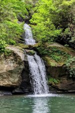
Lake Jocassee and the surrounding gorges are among the most beautiful and rugged places on the East coast. The lake is clear and mostly undeveloped. The four rivers that feed into it contain some of the best waterfalls in the southeast. Minor waterfalls cascade directly into the lake.

Wright Creek Falls
PXL_20230505_201856820~2.jpg

The plan was to leave early so we could arrive in South Carolina and hike before check in. Unfortunately a smoke detector demanded a new battery in the middle of the night, so we got off to a late start.

Boat-in camping is officially limited to Double Springs campground, part of Devil's Fork State Park. Designated parking for the boat-in sites is at the north most boat ramp.

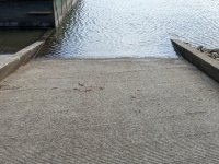
The boat ramp, like everything at Jocassee, is a little challenging. It is too narrow to accommodate a big canoe sideways. The was no dock or beach for loading.
PXL_20240429_150244728.jpg

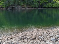
We carried everything down the scree, loaded wet footed, then paddled 20 yards across the cove to a small beach. I prepared the canoe while the kids chased butterflies. A minor cascade roared from behind the foliage.

The scree is rougher, steeper, and less stable than it appears.
PXL_20240429_150311029.jpg

I think the non-motorized boat launch would be a more pleasant place to put in. It would add 0.5 miles to the trip.

Once properly loaded we began the mile crossing to Double Springs campground.
 
Have never been on Jocassee, but have hiked across it's northern rim on the Foothills Trail. Definitely lovely country. I think with a canoe, I'd consider stealth camping at the outlet of the Toxaway River where there is a pretty large designated backpacking spot. At least I remember one there. And I'd just get the boat far enough from shore and hidden so that anyone on the water wouldn't see it.
 
Have never been on Jocassee, but have hiked across it's northern rim on the Foothills Trail. Definitely lovely country. I think with a canoe, I'd consider stealth camping at the outlet of the Toxaway River where there is a pretty large designated backpacking spot. At least I remember one there. And I'd just get the boat far enough from shore and hidden so that anyone on the water wouldn't see it.
Shhhh....

Traveling with two kids I keep to the straight and narrow.

I would really like to paddle up to the north end of the lake, camp, and run the Foothills trail where it comes along the lake.
 
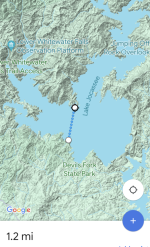
The crossing to Double Springs mountain is about a mile of open water. It is most intimidating when the wind is blowing from the northwest, towards the open part of the lake.
Screenshot_20240506-113017.png

We enjoyed remarkably calm conditions. With the development behind you it feels for a while as if you're paddling off into the mountains. As you approach the opposite shore more development becomes visible to the west. We were also fortunate to have limited motorboat traffic.

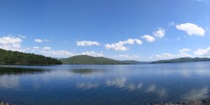
Double Springs mountain is in the middle. The campground is at the right where the mountain meets the lake.
PXL_20240429_150145741.PANO.jpg

At the campground there were two or three aluminum canoes on the shore. Two folks were fishing in what looked like a 15-ish Discovery. There were a few small motor boats.

We landed at the spot the ranger suggested and noticed where larger boats had been beached. We unloaded and with some difficulty carried the canoe completely off the beach into the steep hillside.

Most of the shore of Jocassee is brutally steep. We were pleased the path was walkable the 100 ft up to the campsite.

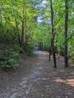
The double Springs campground is essentially built on the old logging road.

Looking down the logging road to the next site. PXL_20240429_133647026.jpg

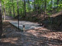
Our site was nice and flat. However, I was a little surprised there is no picnic table like at the walk-in campsites.
PXL_20240429_133627895.jpg

By time we'd made camp and eaten it was truly dark. We return to the beach to wash dishes. The two motor boats had returned and we're now tied up along the beach.

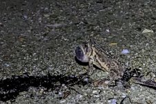
Three American Toads trilled loudly to each other along the water's edge.

PXL_20240429_005718431.jpg

The campground and boat traffic quiet down nicely. The campsite had no indication of large or troublesome creatures so we had no trouble sleeping.
 
We woke to the sound of a motorboat leaving the cove. It was already daylight, but our site was on a westward slope, deep and dark in the trees.

The other campgrounds at Jocassee are plagued by motorboat noise. The boat-in site was far quieter. We heard the two motorboats come and go from the campground. Boats could be heard on the lake, but never too loud.

While cooking breakfast we discover two items we forgot: bug spray and pancake syrup. Thankfully the bugs were not a problem. The pancake syrup was greatly lamented. I suggested we could paddle the 3.5 mile round trip to the ranger station/gift shop/convenience store. Dry pancakes were then readily accepted, perhaps even enjoyed.

Since all the official camping is clustered on the south end of the lake we adopted a base camp style trip. It also reduced the risk of wearing the kids out. We selected Moondance Falls as our Sunday trip. It is a 3.2 mile paddle, mostly along the step side of Double Springs mountain. In many places the banks are sheer stone. There are no major crossings. We enjoyed mild weather and very little wind.

Just before Moondance falls is the outlet for Bad Creek Hydroelectric Station. It is an impressive bunker-like facility carved from the mountain. The kids were a little intimidated, especially after they read the scary signs. We kept to the opposite shore as the mountains closed in and the shore gave way nearly cliff-steep rock.

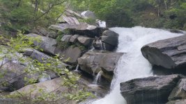
Moondance Falls is the last falls of the Whitewater River before it is flooded by the lake. Less famous than it's upstream siblings Whitewater Falls and Lower Whitewater Falls, it is flanked by shear walls and only accessible by boat. From the lake the falls appear as a boulder piIe. I failed to get good pictures of the approach.

This video on YouTube shows the falls from the lake at about 3:50. It also shows one off Jocassee's ubiquitous northern water snakes.
https.://m.youtube.com/watch?v=pKjE505FYtA

We hopped from the canoe onto the steep rocks and scrambled up to the lowest shear drop. The pictures don't convey how steep and rugged it is. PXL_20240428_144431342_exported_3347.jpg

After scrambling along the middle falls we got back in the canoe and crossed to the other side of the river. There was a small beach where we could land and unload. We had lunch on top of a bus-sized rock where the boulder pile met the lake. Scores of yellow butterflies fluttered around while we ate. I was pleased that Jocassee finally seemed to have lived up to my kids' expectations.

Lunch completed, we loaded up and started back. After about a half mile we found a small beach, maybe 30 ft across, at the back of a cove. We landed to replenish our water and gather firewood. The kids explored the shoreline while I assembled our new water filter.

So far we had not encountered a northern water snake. As I knelt beside the canoe a small snake swam between my feet and the canoe. I tried to run it up the beach but it disappeared under the canoe.

I decided the water would be cleaner pumped from the middle of the lake, and my fingers would be farther from curious reptiles. I called the kids back. My son returned wide-eyed. "There was a giant snake up there! It was longer and fatter than a broom handle!"

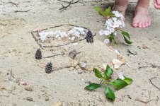
The rest of our trip back to camp was uneventful. Once at camp we lounged around on a beach. We skipped stones and built sand castles. PXL_20240428_184030529~2.jpg

We had dinner and s'mores. After dark we returned to the beach where the toads were calling again. As we watched one toad honed in on the sound of another on a nearby rock. It made an amphibious assault, entering the lake and emerging from the water at the base of the rock. It crawled up the rock to meet it's rival but was repelled, rolling down the rock into the water. The kids cheered and the defeated toad returned to his spot on the beach.

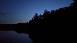
We watched the night sky for a little while then retired for the night.

The night sky from Double Springs campground.
PXL_20240429_010801501.NIGHT.jpg
 
Last edited:
We awoke to a cool morning. There was a gentle breeze blowing through the trees. We had an easy breakfast of Pop-tarts and apple pastries heated on the a-frame toaster.

We broke camp and loaded up. With the two motor boats on the beach we loaded wet-footed. However, it was much easier on the beach than standing on scree or rocks.
PXL_20240429_135852610.jpg

My daughter found a group of salamanders on the beach.
PXL_20240429_010708668.jpg

The gentle breeze we felt at the campsite was real wind on the beach. It was blowing from the south, directly from the takeout, just gentle enough to avoid making whitecaps. The crossing would take longer, but it was safe enough to proceed. I instructed the kids to dig in, and paddle the entire way without slacking off.

As we left the cove another canoe appeared, coming around the point of Double Springs Mountain. I couldn't make out the type of canoe, perhaps a composite tripper. They turned to follow the shore as we continued across the lake.

2/3 of the way across we saw a large bird soaring high overhead. It's wings were too flat across to be a vulture. It didn't have the distinctive bald patches of an eagle. It wasn't behaving like an osprey, and didn't have the right wing structure. It could have been a peregrine falcon, there is an active of nest along the east side of the lake, although this bird seemed bigger than a falcon. We settled on, " Big Bird".

Other birds we saw on the trip were a great blue heron, a kingfisher, and small fork tail birds chasing each other over the lake.

We finished the crossing without drama. While we loaded a paddle boarder came into view. He had stayed at Double Springs campground, carrying his gear in a dry bag on the back of his inflatable board.

Our next stop was Bad Creek station, where I hoped to complete our exploration of the Whitewater River. The kids had previously seen the big one, upper Whitewater Falls. Now they had seen the end of the river at Moondance Falls. We had only been a few hundred yards from Lower Whitewater Falls. But reaching the official observation platform is several miles of hiking.

Bad Creek station has a trailhead access, potentially allowing us into the gorge without several miles of hiking. But Lower Whitewater Falls is a dangerous place. It starts with a gentle slide before the sheer drop. The most recent victim seems to be a Clemson student who fell in 2018.

In the early '70s the falls claimed two couples in a Cessna. It must have been a glorious flight, seeing the fall line along the Toxaway, Horsepasture, Thompson, and Whitewater gorges. But something went wrong at Lower Whitewater. The plane is still there today.
PXL_20240429_174131157.jpg
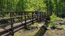
We reached the plane, but it was too steep to go deeper into the gorge by ourselves. We retreated and continued our hike along the Whitewater River on a spur of the Foothills Trail.

The Sierra Club described Jocassee Gorges as "National Park quality", and the Whitewater River lives up to this description. Thankfully it wasn't far to the parking lot, as the kids were exhausted after a few miles.
PXL_20240429_183345688.jpg

Our last planned stop was our end-of-trip meal. An hour later we were south of Asheville enjoying burgers, fries, and ice cream.

It was a great trip. We had great weather and no real problems. The kids enjoyed their first multi-day trip. We did as much as we reasonably could have, but still haven't seen the whole of even the Whitewater River.
 
Last edited:
Late to your report, MrP. Sounds like a very nice family trip. Thanks so much for taking the time to write up the details and posting the photos.
 
2/3 of the way across we saw a large bird soaring high overhead. Its wings were too flat across to be a vulture. It didn't have the distinctive bald patches of an eagle. It wasn't behaving like an osprey, and didn't have the right wing structure. It could have been a peregrine falcon, there is an active of nest along the east side of the lake, although this bird seemed bigger than a falcon. We settled on, " Big Bird”

In all likelihood, based on your description, Big Bird was an immature Bald Eagle. They do not achieve their distinctive white heads and tails until after their third year.

Thank you for the trip report. It’s great to get kids out on the water.
 
Back
Top