• Happy National Paranormal Day! 🔮👻👽

Green River, UT, Water Running Fast, Dumb Idea? Or Just More Work?

Joined
May 7, 2017
Messages
2
Reaction score
0
First off, hi everyone! We are new and are looking forward to meeting others in this community.

I have done three multi day canoe trips including the Green River in Utah twice. This June I was planning on taking my girlfriend on her first Green River trip. We have been planning it for nearly a year and are super excited.

The (possible) problem is that there is a huge run off and the water flow is more than twice "normal". It should still be flat water but it will be running super fast compared to what I have done in the past. As an inexperienced paddler I do not know what to expect.

We don't mind more work. We don't mind if it is hard. However, it obviously wouldn't be fun if our trip consisted of not being able to make land and tipping our canoe and floating miles before being able to get out.

We desperately want to do the trip but are trying to gauge if it will just be harder and require more precautions or if we are idiots for ignoring the conditions and doing it anyway.

Does anyone have any thoughts here? We won't hold anyone to their opinions :) We just want more feedback and information to try to make a good decisions from.

Thanks everyone!!!!!!
 
First, if your questioning the conditions, its probably best not to do it.

Has any others been paddling recently? If everyone else is staying away, you should too. Fast water is more dangerous than it looks. Are there any local paddling clubs you could ask for advice? Or perhaps the state conservation dept. or DNR.

If you did tip over, would you and your partner be able to swim to shore?

Personally, I'd either wait till it slowed down, or go with an experienced 'group'.
 
I have done three multi day canoe trips including the Green River in Utah twice.

The (possible) problem is that there is a huge run off and the water flow is more than twice "normal". It should still be flat water but it will be running super fast compared to what I have done in the past. As an inexperienced paddler I do not know what to expect.

We don't mind more work. We don't mind if it is hard. However, it obviously wouldn't be fun if our trip consisted of not being able to make land and tipping our canoe and floating miles before being able to get out.


Does anyone have any thoughts here? We won't hold anyone to their opinions :) We just want more feedback and information to try to make a good decisions from.

June is a long ways off in terms of predicted water flow. The gauge is now at 13,000 cfs/9.6 feet and mostly trending downwards.

https://waterdata.usgs.gov/nwis/uv?site_no=09315000

(BTW, if you have done past Green River trips you can select the historical data for that year-month-dates for comparison)

I have done Green River trips at low to normal seasonal water levels, where there were exposed sand bars aplenty to choose from as campsite or landings. On launch day a few years ago the gauge at Green River was at 2000 cfs, gauge height at 6.5 feet. It slowly rose over the course of that trip to a peak of 5500 cfs, 7.4 feet.

There were mid-river shallows to be read and avoided, but the river still move along at a couple miles per hour.

With lower level there are more sandbars and (mostly) easier landings, but insufficient water to paddle back into some of the side canyon sites. “Mostly” easier, some of the ledge sites are a long steep/sheer ways above water for disgorging gear. At Turks Head the ledge was an awkward 3 feet above the water.

A year later at the same time of year (late April/early May) we launched at 3000 cfs, gauge height at 6.4 feet and it went to over 10,000 cfs and 9 feet while we were on the river

At high water 30 miles days were a walk in the park, which is good because with the sandbar site overwashed and with fewer sites possibilities everyone is piled together back into the amply watered side canyons.

At Turks head the water was 3 inches below the ledge, but all of the side canyons had plenty of water to poke back a ways. Turks head was crowded with a large no-place-else-to-camp party. With 3 inches of river rise to spare I wouldn’t have camped there anyway.

With that high water paucity of sites I saw folks camped on some awfully low sandbanks remainders. I wouldn’t have slept a wink knowing I had only a foot of river rise to spare.

My only other cautions about high water, using that 13,000 cfs/9.6 feet as a measure, are these:

I would not, as many people do, leave my boats tied off and floating in the river. At peak high water there was some wood floating downriver, and logs bashing someone’s rented Grumman at 3am makes a remarkable sound. Even well back in some the side canyons the water can come up a couple feet overnight.

Or up and down and up; I pulled my canoe up on a small bench at water’s end in Horse Canyon in high water. A couple days later it was 100 feet of foot sucking mud from there to the water’s edge. I know, I foot sucking carried it back down and tied it up on another bench. And the next day I waded out 100 feet down canyon to fetch the canoe and paddle it back to the new high water end.

(BTW, at low water there was also a mudbar at the entrance to Horse, which kept down the number of visitors, so score!)

If you chose to ride the bubble line on the outside of turns try to stay a reasonably safe distance away from the tammies. It is tempting to stay hard on the fastest bubble line a few feet away, but it wouldn’t take much of a mis-stroke to end up disastrously unboated in the bushes.

Entering the side canyons at high water is usually nothing more than an eddy turn. Exiting a side canyon onto the high watered river can be more of a challenge, especially with a narrow canyon mouth and a fast bubble line waiting to catch the canoe. Be aware and plan your exits.

High water and strong upriver winds will create small standing wave trains. They are nothing really, just a bouncy ride with little maneuvering required. Those waves are of course higher on the outside of curves bubble line, but you don’t have to stay in the fast lane; even off the line the river is moving along at a reasonable speed.

The one area where I would be concerned about high water is the confluence with the Colorado. If the Colorado is running high that intersection could be a mess of waves, whirls and confused waters.

A couple trip reports:

(The actual river trip gets started at post #6, the rest is getting there preamble)
http://www.canoetripping.net/forums...ert-SW-travels-and-3-weeks-on-the-Green-River=

http://www.myccr.com/phpbbforum/viewtopic.php?f=163&t=41410
 
The Green flow depends on snowpack of course but more immediately the release from Flaming Gorge Dam
We launched in April at 5500 cfs and of course that day there was a dam release swelling the flow to 12,500 cfs. This made finding up side canyon landings easier. Of course there were no sandbars. The bubble of water lasted but a day and by the time we got to the Confluence to watch NPS kill tammies the water was going low again.

The current is swift but if you can do some basic eddy turns there is no difficulty in exiting site channels.. if you come out too much at a wide angle remember to lean downstream

You really don't want to lose the toilet. Last trip someone did not secure their canoe sufficiently as we found a red canoe floating downriver empty of goods and people. Remember not to leave your boat waterside and secure both ends to the inevitable tamarisk.

Being able to get into the side canyons in my mind is a plus.

You really can't expect to know now what the June level of discharge will be.

Just wear your PFD and if anything happens remember that there are other groups on the river. I'd be cautions about going below the Confluence in high water. Spanish Bottom is the last easy take out and you don't want to miss that one. Cataract Canyon is rafting country with serious rapids!
 
I'll just reiterate from comments above that the water will be up high enough to at least flood most or all the sand/gravel bar campsites. Look at the NRCS Snotel data and you'll see that the Wyoming snowpack is way way above normal, 200% of average in the Wind Rivers and Upper Green River basin, which typically means a later and higher spring runoff. The last big snow year was 2011, take a look at the Green River flow record for that year to get an idea of what's possible. The lack of campsites would make this trip less than ideal from the standpoint of finding a place to camp next to the river. Not all is lost though, if you're willing to leave the boat and hike a little ways inland you can find some great sites off the river. If I were to do a trip during that time I would plan on doing a bit of gear portaging from the tributary canyons and make camp up the dry washes. Pack your gear like you're doing a portaging trip and it'll be easy, especially since you won't have to portage the canoe stuff. Good Luck!

Mark
 
The current is swift but if you can do some basic eddy turns there is no difficulty in exiting site channels.. if you come out too much at a wide angle remember to lean downstream.

The one canyon exit that seemed most problematic when exiting at high water was Deadhorse at mile 20. The mouth is narrow and at the outside bend of a turn, so the bubble line is right there, made worse by a projecting cliff face immediately on the downstream side. Nice one tent two person campsite ledge on that cliff face if you enjoy watching traffic float past, with a landing bench 50 feet up canyon.


I'd be cautions about going below the Confluence in high water. Spanish Bottom is the last easy take out and you don't want to miss that one.

At low water there can be a nice sandy beach on river right at the confluence, with a deep enough drop off for the jet boat to pull up (test for the jet boat required the depth obviously)

A mile or so past the confluence there is a large rock (Scorpion Rock) on river right at also has a jetboat required depth for pick up. There is a good flat campsite there as well, with some cowboy glyphs.

Not going down to Spanish Bottom has distinct jet boat advantages. The shuttle boat goes down to Spanish Bottom and does pick ups on the way back upriver, so waiting at the confluence or Scorpion Rock means you’ll be among the last to get picked up, with less crowd chaos. Plus your (non-rental) boats and gear will go on the jet boat last and be first off when you get back to Moab.

The last night’s campsite for folks taking out on the Colorado is a tricky business. Close enough to get unhurriedly packed up and paddle down to Spanish Bottom (or before), with time to unload/stage gear and wash the boats before the jet boat arrives.

Shot Canyon/Water Canyon at mile 4.5 is a very scenic site, with space for 6 or 7 well scattered tents. And also the tailhead for some hikes, so very popular. And if you miss the unimpressive site landing break in the tammies ¼ mile above the actual canyon mouth at high water you aren’t paddling back up.

Past Shot/Water there are only a couple of decent high water camp sites before the Colorado, both on river right. An elevated one around mile 3 has a fine view upriver.

We don't mind more work. We don't mind if it is hard. However, it obviously wouldn't be fun if our trip consisted of not being able to make land and tipping our canoe and floating miles before being able to get out.

We desperately want to do the trip but are trying to gauge if it will just be harder and require more precautions or if we are idiots for ignoring the conditions and doing it anyway.

To address those actual questions:

I do not know how high would be too high. Certainly at 9 or 10 feet it shouldn’t be more work, or harder. At high water with even a modicum of boat control you should be able to find landings and camp sites, especially paddling back into the high watered side canyons out of the current. Just don’t count on finding sandbars and plan your hoped for side canyon daily mileage accordingly, maybe with a Plan B canyon site further downstream just in case Plan A is full or otherwise unappealing.

At the least paddling up into the side canyons to land and make camp eliminates the most likely “tipping our canoe and floating miles before being able to get out” scenarios. You might be able to tip the boat or fall in at an awkward landing back in some canyon, but you and your gear are unlikely to float off downriver inescapably. You could probably just stand up in the water and laugh.

You don’t say where you are putting in, Ruby or Mineral Bottom, or taking out. At high water the 45 miles between Ruby and Mineral Bottom would go by in short order. Mineral Bottom to the confluence likewise.

But I would not want to encourage anyone to do a trip they thought beyond their skills or comfort level.

Where do you plan to put in and take out?
 
And our first trip down the Green was in 2011. But in September. We played bocce on the big sandbank at the inside curve of Spanish Bottom. Yes we had that much room and that little water. It was September though.. We did get snowed on that last night.

Me I am fond of Jasper. Around mile 7. Has wonderful waterfalls too.
 
Thank you everyone for taking the time for such amazing answers. I am so impressed with how much time went into giving such great information. THANK YOU GUYS SO MUCH!
 
And our first trip down the Green was in 2011. But in September. We played bocce on the big sandbank at the inside curve of Spanish Bottom. Yes we had that much room and that little water. It was September though.. We did get snowed on that last night.

Me I am fond of Jasper. Around mile 7. Has wonderful waterfalls too.

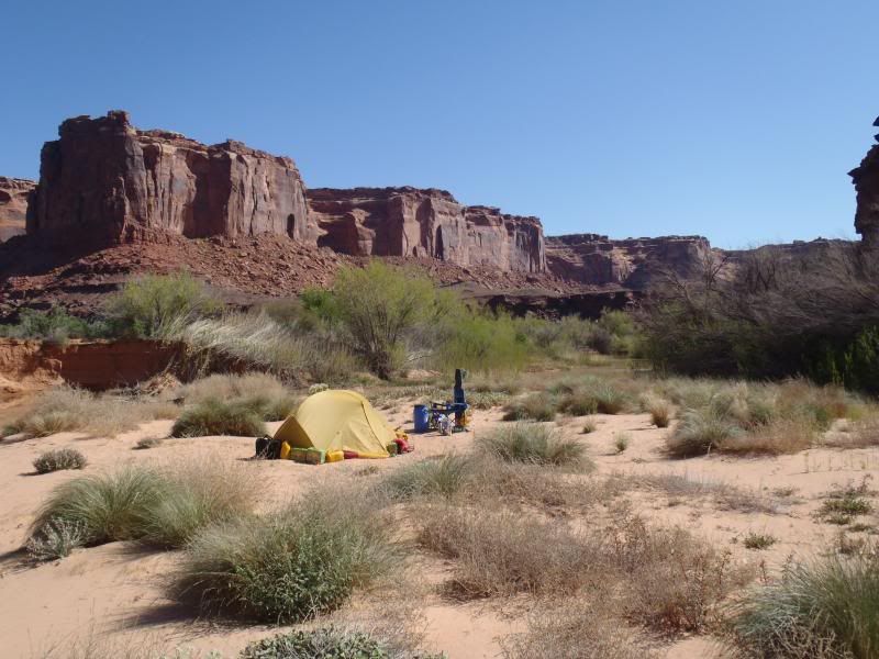
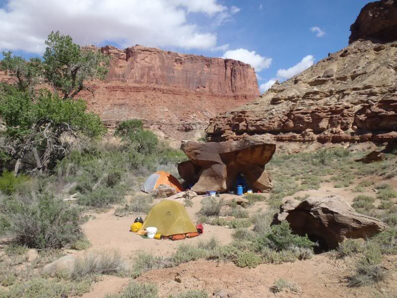
I have yet to camp on an actual river’s edge sandbar on the Green, preferring canyon and ledge sites, even if some are similarly sandy sites further off or above the river. At low water I was tempted by the massive sand expanse at Valentine Bottom; a good square mile of clean, flat sand a few feet above the river, stretching from mile 29 all the way around the bend for a mile downstream. A mile of wind fetch blowing sand would be a b*tch though, and zero shade. Sandbars, meh.

I am so impressed with how much time went into giving such great information.

We ain’t even got started yet. My favorite paddle-up-a-side-canyon sites:

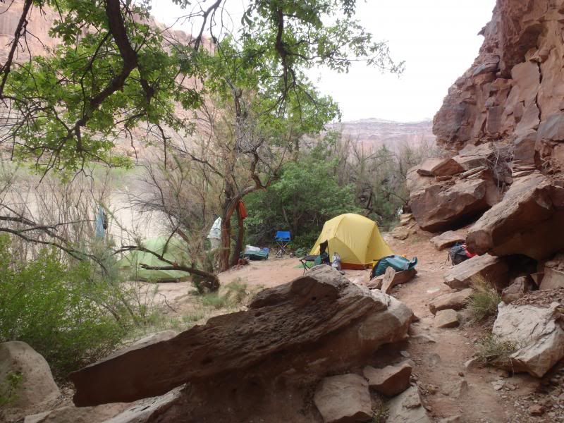
Three Canyon/Trin Alcove (mile 90, river right). Easy landing & launch areas, some promise of clean filterable water up canyon, room for at least a dozen tents on either side of the canyon. Cottonwood shade and as visually stunning as any canyon anywhere along the river. As a top end site, a scant 7 miles downstream from Ruby Ranch, Three Canyon is not to be missed, even if it is campground full.


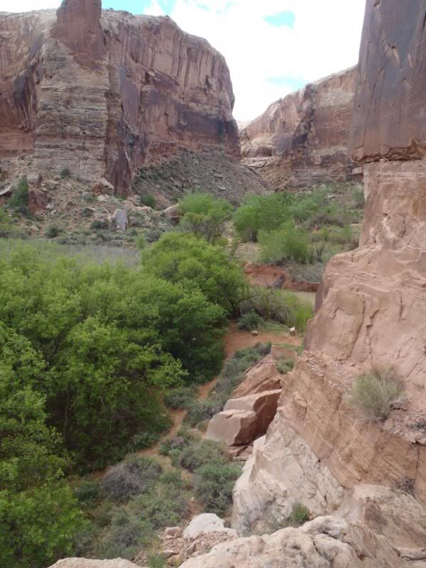
Slaughter Canyon/F Bottom (mile 85.5, river right). Room for 4 or 5 tents with a sandy landing at low levels and a short steep climb at higher water. Not really a paddle-back-into canyon, maybe if the water is really high, but it is along a straightaway and would be tough to stop and land unless well backwatered. Nice cottonwood shade though.


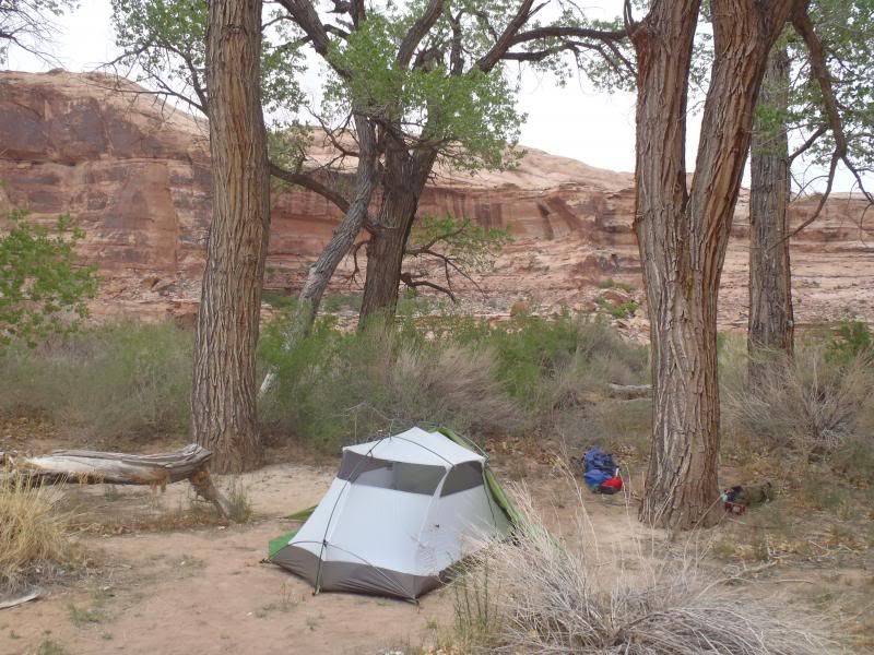
Two Mile Canyon (mile 61, river right). Multiple tent spaces atop a rocky plateau. Cottonwoods and afternoon shade from the western cliff face. (I do appreciate afternoon shade in the desert)


Horseshoe Canyon (mile 59, river right). At high water you can paddle 100 yards up into the canyon and the landing/launch is shallow easy. Not a lot of cottonwood or cliff wall shade though.


Horsethief Canyon (mile 45.5, river right). Multiple level tent sites on both sides of the up canyon backwater, rock carvings, cottonwood and rock shade. Easier sandy bank landing at high water on the north side of the canyon backwater, better sites on the short steep bank and 50 yard gear carry on the south side, especially at lower water when a shallow bench appears.


Deadhorse Canyon (mile 20, river right). No photos, I had a bit of a confrontation with an ahole who staked claim to the entire canyon, but there is room back at the end for dozens of tents, and one very nice high vista ledge site at the canyon mouth. Tricky high water exit, especially if you stupidly stop paddling to chat up the folks camped on that ledge. I almost demonstrated my technique for blathering inattentively and flipping against that rock face when the current grabbed me.

Horse Canyon (mile 14.5, river right. . . . I think I have all those danged “Horse” canyons in the correct order). Deep canyon walls on both sides, and perhaps filterable water in a pourover pool a mile back. That one probably needs reasonably high water to paddle back the shallowing approach into the open sand bench tammie-free end.


Horse Canyon doesn’t offer much in the way of side hiking, it serpentine twists around for a mile or so and end at an impassible dryfall pool. The lack of day hiking more than a mile may keep the Vibram soled riffraff down. It helps that the “trailhead” (and crappy bankside tent sites) for hiking into the Maze is just upstream at Mile 16.


Water/Shot Canyon (mile 4.5, river right). Steep landing, in the current along the outside edge of a turn, and don’t miss the break in the tammies well before the actual canyon mouth. Almost as scenic as Three Canyon/Trin Alcove, but note the end of trip and hiking trailhead site popularity.


Yeah, those are all on river right. That is in part the lay of the land and where the bigger side canyons come in, as well as my preference for morning sun and afternoon shade.

Not a side canyon, and the ledge landing is awkward at low water, but Turks Head (mile 21, river right) has room high up top for 3 or 4 tents. (This is about 7 gauge feet at Turks Head; at 10 or 11 feet the ledge would be a step-out rock dock landing)


I have not camped at Jasper Canyon (mile 9,5, also river right). I’ve always gone another couple miles down to Water/Shot Canyon and hoped there was room at the inn.

I am trying to visualize the Green with another 6 feet of water. I have no idea how much faster the flow, but over 10 feet might actually open up more of the usually dry mouthed side canyons (especially on river left) and old oxbows for easier off-river landing. If there is a stand of Cottonwoods there is probably dry open space to camp.

Sostokedly, the best source of high water information is probably the guys at Tex’s or Tagalong, or whoever is doing your shuttle. The Green is their bread and butter (especially Tex’s) and they have been sending folks out with risk of rental equipment loss for decades. I would trust their high water risk assessment and advice.
 
Back
Top