Until recently, I wasn’t aware of any canoeable rivers in next door Nevada, other than the Colorado below Hoover Dam. However, my friend Jason found references to one within a four hour drive. Two weeks later we loaded four solo canoes on my Tundra and Jason’s 4 Runner and headed west from Park City, UT. My son, Dan, drove down from Sun Valley and met us at the put-in just south of Jackpot, NV (2020 population of 855). This town was founded in 1954 after Idaho outlawed gambling in the state. Two Idaho casino operators simply moved their operations across the state line to more “lenient” Nevada and there are now four or five casinos and not much else in Jackpot.
On the drive over, we were surprised to see big, snow covered mountains west of Wells, NV. I presume that somehow the snowmelt from these impressive mountains provides the flow ,via numerous drainages on the east side of the Sierras, to form Salmon Falls Creek. The Class I section we did ended at the south end of a long (14 miles) narrow reservoir a few miles across the Idaho state line. The shuttle was easy, but about half consisted of rutted dirt roads/trails, and we put in at about 2:30 on May 16. Salmon Falls Creek is an intimate little river which flows south to north from mountains in north/central Nevada to the Snake River in Idaho.


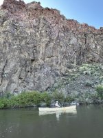
The creek was flowing at 500 to 550 CFS, per the USGS, during our two day trip. It has reportedly been run at as low as 150 CFS, but requires walking/dragging at that level. The 500 CFS was adequate and we had no issues other than some paddle strikes in shallow areas. The creek had been running for nearly 100 miles primarily through high desert terrain and some ranches and was fairly silty. It goes through a series of small canyons, some lined with volcanic rock cliffs. The river is almost constantly turning with many “hairpin” 180 degree turns. As my son Pete said, there was not much time on the water for relaxing or taking photos. If you weren’t actively paddling or at least steering the current would push you into the banks very quickly. Fortunately, the invasive Tamarisk trees have not made it into this drainage. It was a pleasure to paddle past native willows and other varied vegetation rather than the jungles of Tamarisk which infest most western desert river banks. There were very few large trees and no really hazardous strainers.
The put-in was at a highway rest stop with adequate parking adjacent to the confluence of Salmon Falls Creek and Shoshone Creek. Unfortunately, the latter came in from the northeast through farm country and was pretty murky. Visibility into the water was only a couple of inches after the merger. We set off on a bright sunny day with temperatures in the 60’s and minimal wind.

Fortunately, we were aware of a mandatory portage around a riverwide dam about three miles from the put-in. The old, rusty sign warning of a dam in 500 feet would have been easy to miss, and the first several portage takeouts were totally overgrown. The last one was about 30-40 feet from the lip and only had room to take out one canoe at a time. Luckily the river is backed up behind the dam for a few hundred feet which slowed the current. The takeout was muddy and very slippery. Three of us ended up waist deep after slipping on the muddy bank. The portage was an easy 150-200 yards and we enjoyed running part of the wave train below the dam runout.

The infamous afternoon desert wind picked up shortly after the portage. We now had to deal with the combination of the pushy current and buffeting of the wind as we were constantly changing directions down the sinuous river bed. Even fully loaded with camping gear, firewood and drinking water it took a lot of effort to keep the boats from skittering across the river when the gusts hit. We all concurred with the guide book that it may be a Class I section, but it wasn’t for inexperienced paddlers! Draws, cross draws, cross forward, back sweeps, etc. were all extensively used as we negotiated the tortuous course with the unappreciated “wind assist’’. The scenery was very good- not as colorful as the red rock canyons of the Green, Colorado, San Juan or Dolores, but still very interesting with a lot of strange formations in the black volcanic rock.


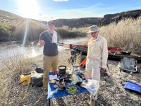
The guide book indicated that there would be numerous good gravel bar camp sites after the intersection with Cottonwood Creek on river left. As my GPS showed the miles accumulating, we watched in vain for the creek. One problem with using a GPS for mileage is the unknown addition to the cumulative distance shown resulting from crossing the river numerous times. Even at 20-50 feet per crossing, it adds up and we were not sure exactly how far we had really gone. We never spotted the elusive Cottonwood Creek and finally decided to camp before we got too far down the river and out of the scenic canyon area. Peter located a nice fairly level gravel bar on the inside of a hairpin turn with a relatively easy takeout. We soon had our four tents and a kitchen area set up in the golden late afternoon sun. I really enjoy watching the setting sun reflecting off of the current and ripples in a river, and this afternoon provided a visual feast.

The fleet at rest.

Dinner consisted of sliced cheddar cheese on flour or corn tortillas fried in butter in my little cast iron pan. My old Trangia alcohol stove provided the heat. After the cheese was melted we added fresh avocado slices and salsa. They were delicious, as usual. I learned of this meal from Ed Gillette, the famous sea k*y*ker who completed a solo, unsupported trip in a tandem sea k*y*k from San Diego to Hawaii in 1987. He later provided guide services for k*y*k trips along the Pacific coast of Baja, Mexico, and we were fortunate to take one and got some culinary instruction as well as sea cave exploration and surf lessons in the long boats.

The temperature dropped quickly after sunset, and we were happy to sit around a small campfire (we brought our own firewood from home) for a few hours reminiscing and savoring the quiet desert. I usually shove a stick into the sand/mud at water’s edge to determine changes in the water level over night. The next morning we were surprised to see that it had actually risen during the night and then fallen below “stick gauge”. The fluctuations were probably due to temperature changes in the mountains affecting the rate of snowmelt. The lag time for the changes in water volume to show up at our location could be days, due to the distance involved. That morning we splurged and had Kodiak pancakes with butter and genuine maple syrup, rather than our typical oatmeal. This was a throwback to the annual trips the boys and I made during the 1980’s to Maine or the Adirondacks. We always had pancakes and often pan flipping contests.

The morning was pretty calm and we enjoyed maneuvering down the river, practicing eddying out where possible while keeping an eye out for a white 4Runner, or the remnants of one, parked up in a clearing on river right. It eventually came into view and we managed to crowd into a small eddy adjacent to a two foot mud bank. Jason was relieved to find our vehicles undisturbed and we were soon packed up and on our way back to the put in.

We all enjoyed the trip and resolved to do it again. It reminded me in some ways of the section of the rarely runnable Dolores River in western Colorado near Bedrock and Slickrock. At 500 CFS Salmon Falls Creek had plenty of water and required near constant attention, but was not life threatening (except for the dam if someone missed the pullout). There were no bugs at all, no snakes were seen, and the only people were in a couple of cars at the put in, which was a highway rest stop. Other than a couple of power lines near the beginning, there was no sign or sound of civilization. The canoes: Dan and I traded time in the Mohawk Odyssey 14 and Mad River Guide. We both liked the Guide better for acceleration and responsiveness. However, the Mohawk had more initial stability and a larger carrying capacity. Jason enjoyed his first canoe camping experience in his newly acquired Royalex Bell Yellowstone, and Peter loved the performance of his Kevlar MR Courier, as usual. All of us appreciated the sub 15' lengths on this beautiful, twisty little river.
On the drive over, we were surprised to see big, snow covered mountains west of Wells, NV. I presume that somehow the snowmelt from these impressive mountains provides the flow ,via numerous drainages on the east side of the Sierras, to form Salmon Falls Creek. The Class I section we did ended at the south end of a long (14 miles) narrow reservoir a few miles across the Idaho state line. The shuttle was easy, but about half consisted of rutted dirt roads/trails, and we put in at about 2:30 on May 16. Salmon Falls Creek is an intimate little river which flows south to north from mountains in north/central Nevada to the Snake River in Idaho.
The creek was flowing at 500 to 550 CFS, per the USGS, during our two day trip. It has reportedly been run at as low as 150 CFS, but requires walking/dragging at that level. The 500 CFS was adequate and we had no issues other than some paddle strikes in shallow areas. The creek had been running for nearly 100 miles primarily through high desert terrain and some ranches and was fairly silty. It goes through a series of small canyons, some lined with volcanic rock cliffs. The river is almost constantly turning with many “hairpin” 180 degree turns. As my son Pete said, there was not much time on the water for relaxing or taking photos. If you weren’t actively paddling or at least steering the current would push you into the banks very quickly. Fortunately, the invasive Tamarisk trees have not made it into this drainage. It was a pleasure to paddle past native willows and other varied vegetation rather than the jungles of Tamarisk which infest most western desert river banks. There were very few large trees and no really hazardous strainers.
The put-in was at a highway rest stop with adequate parking adjacent to the confluence of Salmon Falls Creek and Shoshone Creek. Unfortunately, the latter came in from the northeast through farm country and was pretty murky. Visibility into the water was only a couple of inches after the merger. We set off on a bright sunny day with temperatures in the 60’s and minimal wind.
Fortunately, we were aware of a mandatory portage around a riverwide dam about three miles from the put-in. The old, rusty sign warning of a dam in 500 feet would have been easy to miss, and the first several portage takeouts were totally overgrown. The last one was about 30-40 feet from the lip and only had room to take out one canoe at a time. Luckily the river is backed up behind the dam for a few hundred feet which slowed the current. The takeout was muddy and very slippery. Three of us ended up waist deep after slipping on the muddy bank. The portage was an easy 150-200 yards and we enjoyed running part of the wave train below the dam runout.
The infamous afternoon desert wind picked up shortly after the portage. We now had to deal with the combination of the pushy current and buffeting of the wind as we were constantly changing directions down the sinuous river bed. Even fully loaded with camping gear, firewood and drinking water it took a lot of effort to keep the boats from skittering across the river when the gusts hit. We all concurred with the guide book that it may be a Class I section, but it wasn’t for inexperienced paddlers! Draws, cross draws, cross forward, back sweeps, etc. were all extensively used as we negotiated the tortuous course with the unappreciated “wind assist’’. The scenery was very good- not as colorful as the red rock canyons of the Green, Colorado, San Juan or Dolores, but still very interesting with a lot of strange formations in the black volcanic rock.
The guide book indicated that there would be numerous good gravel bar camp sites after the intersection with Cottonwood Creek on river left. As my GPS showed the miles accumulating, we watched in vain for the creek. One problem with using a GPS for mileage is the unknown addition to the cumulative distance shown resulting from crossing the river numerous times. Even at 20-50 feet per crossing, it adds up and we were not sure exactly how far we had really gone. We never spotted the elusive Cottonwood Creek and finally decided to camp before we got too far down the river and out of the scenic canyon area. Peter located a nice fairly level gravel bar on the inside of a hairpin turn with a relatively easy takeout. We soon had our four tents and a kitchen area set up in the golden late afternoon sun. I really enjoy watching the setting sun reflecting off of the current and ripples in a river, and this afternoon provided a visual feast.
The fleet at rest.
Dinner consisted of sliced cheddar cheese on flour or corn tortillas fried in butter in my little cast iron pan. My old Trangia alcohol stove provided the heat. After the cheese was melted we added fresh avocado slices and salsa. They were delicious, as usual. I learned of this meal from Ed Gillette, the famous sea k*y*ker who completed a solo, unsupported trip in a tandem sea k*y*k from San Diego to Hawaii in 1987. He later provided guide services for k*y*k trips along the Pacific coast of Baja, Mexico, and we were fortunate to take one and got some culinary instruction as well as sea cave exploration and surf lessons in the long boats.
The temperature dropped quickly after sunset, and we were happy to sit around a small campfire (we brought our own firewood from home) for a few hours reminiscing and savoring the quiet desert. I usually shove a stick into the sand/mud at water’s edge to determine changes in the water level over night. The next morning we were surprised to see that it had actually risen during the night and then fallen below “stick gauge”. The fluctuations were probably due to temperature changes in the mountains affecting the rate of snowmelt. The lag time for the changes in water volume to show up at our location could be days, due to the distance involved. That morning we splurged and had Kodiak pancakes with butter and genuine maple syrup, rather than our typical oatmeal. This was a throwback to the annual trips the boys and I made during the 1980’s to Maine or the Adirondacks. We always had pancakes and often pan flipping contests.
The morning was pretty calm and we enjoyed maneuvering down the river, practicing eddying out where possible while keeping an eye out for a white 4Runner, or the remnants of one, parked up in a clearing on river right. It eventually came into view and we managed to crowd into a small eddy adjacent to a two foot mud bank. Jason was relieved to find our vehicles undisturbed and we were soon packed up and on our way back to the put in.
We all enjoyed the trip and resolved to do it again. It reminded me in some ways of the section of the rarely runnable Dolores River in western Colorado near Bedrock and Slickrock. At 500 CFS Salmon Falls Creek had plenty of water and required near constant attention, but was not life threatening (except for the dam if someone missed the pullout). There were no bugs at all, no snakes were seen, and the only people were in a couple of cars at the put in, which was a highway rest stop. Other than a couple of power lines near the beginning, there was no sign or sound of civilization. The canoes: Dan and I traded time in the Mohawk Odyssey 14 and Mad River Guide. We both liked the Guide better for acceleration and responsiveness. However, the Mohawk had more initial stability and a larger carrying capacity. Jason enjoyed his first canoe camping experience in his newly acquired Royalex Bell Yellowstone, and Peter loved the performance of his Kevlar MR Courier, as usual. All of us appreciated the sub 15' lengths on this beautiful, twisty little river.