• Happy International Mermaid Day! 🧜🏼‍♀️

Algonquin Park 2021: Tim Lake - Nipissing River - Magnetawan Lake Loop

Joined
Mar 16, 2022
Messages
30
Reaction score
37
malt 2.JPG
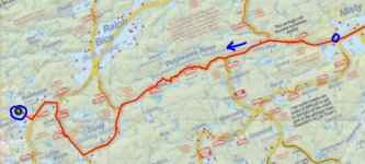
Tim Lake – Nip R. – Magnetawan Lake Loop

Total travelling distance = 127 km. 42 portages, totaling 17,370 m, the longest being 2,140 m.

Trip Overview.JPG
This was our "big" trip this year (2021) and with Covid and VAC time shuffling life around it was exactly what we needed to center ourselves.
The prep for this trip was straight forward. Stove fuel was easier to procure this year, hotel vacancy was not an issue for the drive up, and Rich had spent many lockdown afternoons preparing the dehydrated meals for the year. We could not find a 4th person, so we were going into the park with one tandem canoe and myself going solo.

Goals of the trip were the following:
- Avoid some of the Covid Crowd on HWY60, hence the Tim Lake access point choice.
- Complete the last remaining stretch of the Nipissing River that Ryan and I had not already experienced (Loontail junction to the P1930 into Remona)
- take Rich into some of the big, beautiful lakes south of Catfish (our favourite area of the Park)
- see some of the historical locations on the Nipissing River and Burntroot Lake.
- visit two interior Ranger Cabins (Highview and White Trout).


The one obstacle we did have to overcome was the lack of campsites close to the Tim access on the last night of our trip. Everything was booked solid all the way up past Longbow (at the time we were planning on coming out the Tim River). This meant we would need to exit the Park at Magnetawan. We drove up in two vehicles and had to perform the one-hour car swaparoo on the first and last day. A bit of a pain, but in the end a small price to pay for an epic week.

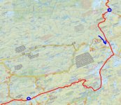
Day 1: Tim River (access point) to Nipissing River (Grass Lake)
Total travelling distance = 24.5 km including 11 portages, totaling 3,135 m, longest being 820 m.

day 1.JPG

We had previously completed this section on a spring trip in 2018 and knew exactly what to expect. We knew it was going to be a full day, especially with the wasted time of car juggling before even pushing off in the boats.

It was a decently cool morning for August, and it was calling for rain by midafternoon.
One of the first things we noticed when launching at the Tim access was how high the water levels were. The small dock at the launch point was 5-6 inches under water. With much of our scheduled trip taking place on rivers, this excited me more than it should have. We also noticed, by visiting two access points, that there were a ton of people in the Park.

The stretch of the Tim River from the access point to Tim Lake is a really nice paddle. An excellent first 20 minutes to the trip, which likely can’t be beat by many other access points. Tim Lake was fully occupied, and we had already passed 3-4 loaded boats leaving the Park. Behind us to the west we could see the towering rain clouds approaching.

The portages between Tim and Big Bob are not overly hard, but they are up hill and with the recent rain they were muddy/slippery. On the first portage Rich managed to slip and fall while descending towards Chibiabos. He twisted his ankle pretty good but was confident he was good to continue. On one of the final portages into Big Bob Ryan also slipped and fell forward into one of the many mud filled quagmires. No damage to Ryan, just some muddy clothes and hands. These lakes are small but feel secluded while still being very close to the access point.

We had planned to stop and eat lunch on the beach on the eastern end of Big Bob. This plan was thwarted by the previously noted high water... the beach was now a sandy bottom on a weedy shoreline. I was less excited about water levels at this point. We elected to not eat at the campsite we passed on Big Bob (it really is an excellent spot) and elected to stop and eat at the falls on the P200m into the Nipissing.

At the end of the portage there is a bit of pulling and weaving to get yourself out to the main flow of the river. The path is fairly obvious through the rushes when travelling in our current direction, but from experience it is less obvious when trying to leave the Nipissing towards the portage.

The section of the Nipissing from the P200 to the third campsite down river is fantastic. The river is wide and reasonably straight, we usually see some wildlife (moose), and the portages are easy (plus they bypass awesome rapids / waterfalls). These rock formations are quite oxidized and are flanked on both sides by towering white pines, so when fishing in the pools at the bottom the backdrop is stunning. Enjoy this stretch while you can, as the next 3-4 hours of your day will be terrible.

Shortly after the third campsite the river narrows, and the alder becomes the focus of your attention. There are a few sections that require some lift overs, and some sections where cutting of alder was required. For the most part, we were queued up behind each other and were pulling our way down stream, paddles optional. During this time the expected afternoon rain also began, so things got very wet and miserable. Just when you are about to lose your patience, when all hope appears to be lost, the river widens again near the 4th campsite down river.

We considered staying at this campsite, as we were all very cold and wet (we were shivering uncontrollably, which goes to show that even in August body temp can be a concern), but the campsite was garbage. There are actually very few good campsites on the Nipissing River, especially for hammock campers.

We made the wise decision to push on into the quickly fading light and arrived at our campsite on Grass Lake shortly after sunset. Grass Lake is essentially a wider spot in the river with one or two large switch backs through the weeds. The campsite is top notch though, and once we had a roaring fire going we all quickly forgot the trials and tribulations of the afternoon. Night one is normally a fresh meal, so on the menu was a full pork tenderloin , twice baked potatoes and fried peppers all washed down with a litre of the finest boxed wine.

We had fished the bottom of all the portages we could with not a single nibble all day. Our quest for the Nipissing brook trout would need to continue in the coming days.


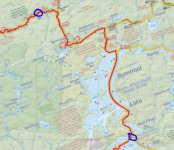
Day 2: Nipissing River (Latour Creek) to Nipissing River (Highview Cabin)

Total travelling distance = 13.9 km including 6 portages, totaling 850 m, longest being 365 m

day 2.JPG


We awoke to a calm, misty morning. One of those damp and quiet mornings where nothing seems to be moving. That included Rich and Ryan, who slept until the coffee was already perked and the bacon was sizzling. After packing up and eating our bacon / egg / cheese wraps we slipped into our still damp clothing from the day prior. This has got to be one of the worst feelings you consistently get while in the back country, something that no one is looking forward to.

We left the campsite later than we had hoped, but the plan for the day was not as ambitious as the day before. Our plan was to head downstream past the Highview cabin to the campsite at the end of the Nod Lake portage, around 19 kms in total.

As we made out way through the section of river before the Loontail Creek junction we seemed to be waking up every single duck / goose in the Park. The morning was very calm, with a slight fog, and we were paddling fairly quiet, so during every twist and turn of the river we were met with the rapid flutter of wings from the startled waterfowl.

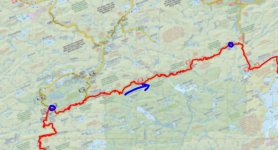
Once we passed the junction Ryan and I entered the final section of the Nipissing that we had yet to experience. For many years we had planned and dreamt of completing this portion of the river, and finally we were making it a reality.

The river does bend back and forth quite a bit, but not as monotonously as the lower end of the Nipissing near Cedar Lake. The portages are very simple, not long, and they typically hug the shoreline. Some care needs to be taken when on these river portages though, as the grasses can grow up and obscure your view of the holes and rocks by the riverbanks.

We avoided several of the portages entirely, as the water was high, and the obstructions were not difficult to avoid. Some of the portages take you around a blind corner, so we elected to portage all of those. In hindsight, all of those ended in rocky drops at the bottom end so we correctly elected to portage.

The campsites on the P365m (High Dam) were half decent, but most of the campsites in this stretch appear to see little use. The access to the river sites are not great due to the high riverbanks (and we were in high water) and the available space is limited at most sites.

We fished the bottom end of all of the portages and started to get some nibbles. At the bottom of the P90m and P110m I was able to hook on to a brook trout but was not able to land either.

The section leading up to Dogay’s dam is exceptionally nice. The river is wide, slow, and the shoreline is dotted with massive white pine. Rich and Ryan were likely annoyed by my occasional comments regarding how much I enjoy sections of river like this… how each bend in the river looks like a post card to heaven etc etc. There are many things I enjoy in the Park. Some involve big lakes and sunsets, but most involve quiet rivers and solitude.

On the P155m around Dogay’s dam Rich managed to stumble over some blowdown and took another tumble on his sore ankle. At the end of the portage Rich dipped his ankle into the cool water to bring down the swelling, while Ryan and I patiently fished the pools. I managed to catch a few little brookies, nothing worth keeping. We wrapped up Rich’s ankle with a tensor bandage we carry for such occasions and paddled on.

When we got to the forked portage (P100 to fork, P2865 to Gibson’s Lake, P875 to Nipissing) we started thinking about finding home for the night. This would leave us nearly 5 km’s behind schedule (1 hour) but it would let Rich put his foot up and rest his ankle for the night. When we got to the first campsite on the portage it was filled with lots of fallen / cut trees. The prospects for finding suitable hammock spots was limited, and overall it was not a very appealing campsite. Halfway down the portage we finally made it to one of the ranger cabins that I was the most interested in visiting, the Highview cabin.

This little ranger cabin is positioned 10-12 feet above the Nipissing River and has a nice little view back upstream. You will know you are close when you see a large rectangular clearing on the left-hand side of the portage. Clearings like this always get my nerves up, as I think they would be perfect locations for bears to sit in the high grass munching on berries. Alas, no bear encounter on this trip.

The cabin is pretty remote, and one of the harder cabins to reach for most people but was in decent shape. The cabin itself is set very low and requires a taller person to duck to enter but once inside it is very cozy. Around the cabin, on the walls and in the grasses close by, there are a multitude of relics from years gone by. An old broken-down cast-iron stove, various cans and metal implements can be found if you poke around. The side of the cabin has various saws and wheel rims, plus a massive set of moose antlers. Behind the cabin there is a rare sight in the Park, a fully roofed outhouse.

With the condition of the party, and the appeal of having a roof over our heads and a stove to dry out our gear, we decided to stay the night at the cabin. Rich took some Ibuprofen and elevated his ankle, Ryan started the fire and made dinner, and I caught some fish down by the river.

After we played some cards and swapped some stories we settled down for a much-needed rest. Before going to bed we stepped out into the clearing and took in a perfectly cloudless sky and the multitude of stars visible. It is nights like this, surrounded by good friends, in such a beautiful setting that recharges the soul and cements in your mind a memory that will last a lifetime. Tomorrow is another day, and we are now behind schedule and hopefully Rich’s ankle responds well to the rest.


Attachments

  • malt.JPG
    malt.JPG
    41.9 KB · Views: 3
  • day 6.JPG
    day 6.JPG
    85 KB · Views: 2
  • day 5.JPG
    day 5.JPG
    92.4 KB · Views: 0
  • day 4.JPG
    day 4.JPG
    107.5 KB · Views: 0
  • day 3.JPG
    day 3.JPG
    82.3 KB · Views: 1
Day 3: Nipissing River (Highview Cabin) to Nipissing River (High Falls)
Total travelling distance = 25.5 km including 6 portages, totaling 5,475 m, longest being 2,140 m

day 3.JPG

Day three started with a very calm and chilly morning. We all had a wonderfully warm sleep, so the contrast when stepping outside was noticeable. After a few pots of coffee and some farmer’s wraps we were ready to tackle the day. We were looking forward to camping near High Falls and since we had not seen anyone else since leaving Tim Lake we were not worried about competing for campsites today.

First things first, we needed to complete the portage we were on and start making up the 5 KM of river we had left from the day before.

While sitting in my canoe waiting for the fellas to load up, I decided to fish a few of the little pools in the river. I landed the second biggest brook trout of the trip, so this day was already shaping up to be a good one! I am always shocked with how lightly brook trout hit the lure, and for their size they certainly don’t put up much of a fight.

It was an uneventful paddle down to the campsite on the end of the Nod portage. We were fairly quiet and were just trying to make up some miles. Upon reaching this campsite we stopped to check it out, and to have a quick snack. Thank the camping gods we decided to stop at Highview as this campsite was less than ideal. The main campsite is set back to the right off the portage, up a small hill and into a tiny firepit that is encroached on all sides by brush. On the river side there is alder and brush as well, so a view of the river is not even possible. As we munched on some trail mix we joked about how we would even have set up the hammocks, and sat around the rarely used fire pit. Note to self, avoid this campsite in future trip plans.

The portage around Stewart’s Dam was similar to most of the portages the day before but with a nice field of ferns halfway through. You never stray too far from the sound of the river, and this would happen to be the first maintained portage of the trip. On the bottom end of the portage the river splits slightly and flows into a nice little pool. We floated around here briefly, trying to hook into some more brook trout without luck.

This section of river is quite wide and straight, with banks of high alder over which the shoreline pine trees loom. It was a beautifully warm morning, but as noon approached (and the P2140m portage) the heat of the day was becoming more noticeable.

With the high water levels, we were able to easily pass over some small swifts and then we were at the biggest portage of the day. The portage around the Allen Rapids is not overly difficult but it is long enough to get the heart pumping. The footing is excellent, and as the trail moves away from the river it does gain in elevation while passing through a nice forest. It is actually a nice change of scenery from your typical Nipissing River portage experience. When the trail returns to the side of the river close to the campsite, there are several spots where you can access the water for some fishing in the rapids. We caught more snags than anything else. We also had some laughs while trying to get our lures back while wading in the river. At the end of the portage Rich decided to go for a swim, partly to cool off (he is not a big fan of long portages… I guess no one really is) and partly to soak his ankle. So far today, with the extra wrapping on his ankle, and the better footing on portages, he was able to avoid any more twists or falls.

As we travelled towards the Kelly Creek junction, we actually saw the back end of a bull moose on two separate occasions. Both times we were not able to get the cameras up in time to catch them, but we did sit in the river and listen to them crashing back into the bush. It has been many years since we have seen a bull moose in Algonquin, with the last time also being a trip out of the Tim access.

Between the junction and Graham’s Dam we started seeing some really large logs floating in the water or hanging out from the shore. This in itself is not odd, but we did note the large size of some of these logs as we passed by. Eventually we ran into the floating log meet up spot, and what a party that was. You blindly come around a bend in the river and run into 10-15 meters worth of stacked up logs completely blocking the river. We pulled over to river right and disembarked on to a massive log. With multiple people standing on it, it still had enough buoyancy to stay afloat with ease, just a slight rocking. Over the next 20 minutes we picked our way across this obstruction carrying the bags and boats and attempting to not fall through the cracks into the river below. We managed to get over without any issues, no holes in boats, no twisted ankles, just some good ole sweat, curses, laughs, and hard work.

The campsite before the P410m portage (Coldspring Cr Junction) is not very appealing from the water and it did not seem to be used often. In hindsight, this is likely because the campsite on the P410 is awesome. This portage is a quick up and over carry. Some parts have sandy footing and there were several downed trees to work around. The campsite itself is smack dab in the middle of the carry, and has a nice, elevated view of the rapids below. Excellent fire pit area surrounded by massive white pines with a spot off the back that is levelled for sleeping pads etc. If I am back through this area, this is the campsite I will be targeting.

For several months we had been looking forward to poking around at the downriver end of the P365, which is marked as “Spring Camp” on Jeff’s Map. I do remember seeing a clearing at the end of the portage, but at the time I was daydreaming about the brisket meal we were going to prepare that night for supper. I had also planned to set the boat down well before the end of the portage to fish the pool at the bottom, in which I landed the biggest brook trout of the trip. I am disappointed we did not snoop around the POW camp remnants, but as a silver lining, I caught the largest brook trout of my life and have also given myself a reason to return in the future. Win / win!

When we arrived at the final portage of the day, the P1300m around High Falls, we decided to double carry. The plan was to carry the boats to the bottom end and check out all three campsites on the way back before returning with the bags. The first campsite is right at the top end of the portage, and again had downed trees and overall, it was not very appealing. The second campsite is well past High Falls and is not typically the type of site we would pick. In looking at the map from afar, it looks like the 3rd campsite is at the end of the portage but when we got to the river, we realized our error. If you look closer, the third campsite is slightly downstream from the put in. The river is extremely low in this section, even in high water, so we attempted to walk our way down the river to check it out. We got most of the way there, but then had to shuttle ourselves over a small deep section with a canoe. This campsite south of the High Falls portage is really really nice. It feels like a lake campsite, wide open, great view, and most importantly a brand-new thunder box and metal artifacts. At the time, we decided that this was going to be home for night three and we headed back to get our bags.

On the walk back we stopped at High Falls, and this is something that everyone should see. The falls itself starts with a small waterfall upstream, and then ends with a large waterfall at the bottom. You will hear this set long before you see it, especially with the massive Canadian shield reflecting the sound. When sitting on this rock, taking in the sights, sounds, and rumble, I couldn’t help but label this the “Niagara Falls of Algonquin”.

Needless to say, with the extra time we spent at the falls and after returning for our bags at the top of the 1300, we were running out of daylight by the time we returned to the 2nd campsite on the portage. Instead of carrying on to the better campsite downstream, we decided to settle for this campsite instead. We made sure to hang our hammocks as far off the portage trail as possible even though we knew it was unlikely to have anyone pass us by. The Park staff must have been busy in this section, as this campsite also had a brand-new thunder box. We enjoyed a brisket and potato dinner, and likely too much scotch and amaretto, and headed to bed to the gentle sound of the Nipissing River passing us by.

 
Day 4: Nipissing River (High Falls) to Redpine Bay
Total travelling distance = 13.4 km including 4 portages, totaling 3,725 m, longest being 1,930 m

day 4.JPG

We woke up to a beautiful morning, and some booze induced headaches (or at least I did). Even with a cinder block for a head, I decided to treat the fellas to some pancakes and bacon. The sugary goodness, in addition to a couple pots of coffee, got us feeling ready to portage our way out of the Nipissing watershed.

The quick paddle to the P1930 was a milestone for Ryan and I. This was the final section of the Nipissing we needed to paddle to complete the entire river inside the Park. It was a short lived feeling, as we began portaging uphill to Remona. In 2015 Ryan and I had travelled this portage going in the opposite direction, and I have a vivid memory of this portage, although long, being a nice downhill walk on a nice wide trail to the river. This was confirmed as we trudged our way up the gradual incline, on a nice wide trail, to the lake. Rich had a pretty tough portage, and several times got to experience his breakfast again. Around where the access trail crosses the portage we ran into some park staff coming the other way with chainsaws. We exchanged quick greetings and we made sure to thank them for their hard work before carrying on.

When we arrived at Remona we were all very winded and hot, so a quick swim was in order. It was really nice to finally be back on a larger body of water, and to feel the wind on our faces again. Additionally, it was splendid to drink some water that was transparent and not the colour of weak tea.

We made quick work of Remona, Whiskey Jack, and Robinson lakes, and got to enjoy a slight tailwind on each of them. The portages between them were quite muddy at the put ins, but no one managed to step in the wrong spot. I have taken a strong liking to Whiskey Jack Lake in particular, some of the campsites and the colour of the water really does it for me.

We stopped to each a quick lunch at the start of the P1285m , and then made short work on this trail into another one of our favourite lakes, Burntroot Lake. When we got to the end of the portage, we quickly realized that the tailwind we enjoyed earlier was now going to slow down the rest of our journey. The plan was to head to the north end of the lake, to show Rich the root cellar located near the Portal Rapids, then head to the southwest to check out the alligator remnants. Even with the wind, we decided that we may not be back on this lake any time soon so we might as well check it all out.

We rode the waves into the north end, passing what appeared to be a nude sunbather on the beach site just south of the P155m. A quick sit inside the root cellar, some photos, some hydration, and we were back in the boats heading south. The going was slow but even while solo I was able to keep the canoe pointed in the right direction. We stopped in the lee of several of the islands as we went, taking little breaks to catch our breath and loosen up some muscles.

Another site we wanted to check out was Anchor Island. This will now be my third time through Burntroot where this campsite was occupied. We chose to pass right by with a wave to the occupants. I am not one to intrude on someone’s solitude (unless in an emergency), so we now have another reason to return to this beautiful lake.

It was getting late in the afternoon when we reached the southwestern bay and began our search for the logging remnants. As we paddled deeper into the bay, we noticed what looked like a roof in the trees to the left of the little creek. As we approached, we realized we were in the correct spot. The alligator remails on Burntroot are in much better shape than the remains found on Catfish. Most of the rudder, boiler, winch, and lower structure is reasonably intact. The upper wood structure is obviously decomposing, leaving the steel gears, pipes, and parts clearly visible. After seeing the boiler on Catfish, it would be hard to envision what an “alligator” was, but after seeing the remains on Burntroot it is amazing to see what these machines really were.

After leaving this contraption, we head over to a very noticeable clearing on the shoreline just east of the Alligator. This sight is where we assumed the “Politician’s Cabin” would be found according to Jeff’s map. We poked around this clearing but could not find any remains or foundations in the tall grass. We spent some time searching along the treeline as well and did find a very old foundation 10-12 feet into the trees. It must be quite old, as an old birch tree is growing right out of the corner of the foundation.

We then loaded up the canoes and decided it was time to finally find home for the night. Our plan was to camp on one of my favourite campsites in the Park, the first island site on Red Pine Bay. It was early evening as we paddled across the south end of Burntroot, and the view was pretty nice looking back into the setting sun. We really should have made better time today, we started to worry that someone else made it the site before us. Today was the first day we had seen people since the morning of day one, but really it was only two groups (Anchor Island and the northern beach site).

As we paddled the narrows into the bay, I was describing to the guys what to expect on the site. When we pulled around the final corner, and the island camp into view I immediately began studying the big rock on the northern side of the island. If anyone was on the site, this is likely where they would be, soaking in the sunlight of another awesome Algonquin day. Much to our delight, the island was empty, and we soon settled in. The campsite is virtually perfect for a group of hammock campers. The trees are perfectly spaced, mature, and plentiful. The firepit is top notch and the lookout from the afore mentioned rock face is excellent. Like most island sites there is usually a lack of readily available firewood, but we did manager to get enough for the evening fire.

While the sun was setting, the three of us sat around on the lookout rock with some 8-year-old Lagavulin and just shot the breeze. We swapped stories about life, love, and camping. We also floated the idea of changing up the trip plan. We grabbed the map and tried to find the quickest and most portage free route to the truck. In light of Rich’s ankle, we decided to make our 4 day return up the Tim River into a 2 day trip up the Petawawa River. This meant instead of going from Red Pine Bay to Shippagew tomorrow (a pretty easy day), we were going to try and make it to Misty Lake instead. From Misty we were going to head out to the access point the following day. Seemed doable (we are not strangers to massive days) so as a group we voted this plan into action. Cheers, now lets eat!

Dinner was homemade, rehydrated pulled pork wraps with copious amounts of spirits. We sat around the fire, quietly listening to some of Rich’s favourite bands while the fire roared. We even had some sort of SKOR bit, peanut butter chocolate pudding treat that Rich brought. All in all, an excellent day. With our big day planned for the next day we went to bed reasonably early with prayers for clear skies and favourable winds on our lips.

 
Day 5: Redpine Bay to Misty Lake
Total travelling distance = 32.5 km including 9 portages, totaling 2,055 m longest being 850 m

day 5.JPG

We woke up early and settled into a hearty oatmeal breakfast with plenty of coffee. Today was going to be a long day. We got very lucky with the weather; all things considered. The wind was down compared to the day before and it was sunny but not unbearable hot. Simply a beautiful August day in the heart of the Park.

Today was a very paddle heavy day with very little portaging until the afternoon. The plan was to get a jump on the day and get most of the big lakes out of the way early. Spirits were high and other than Rich’s ankle we were all in reasonably good physical condition.

We bypassed one of the portages into Longer Lake, neither are very long with the second portage being marked “Poison Ivy on this portage”. Once you arrive at Longer Lake there is a marshy, Lily pad laden start to the lake. It seems like good moose viewing territory though we have never seen one here. Once we turned the corner and headed South we saw a rare sight up to this point in the trip… other paddlers! We passed two canoes on the water, exchanged “Good Mornings”, then landed at the P300m to Big Trout. This portage is a quick little up and over, nothing overly difficult, and you arrive to a superb view looking down Big Trout Lake. The put in on the South side also has a very nice sandy bottom, perfect for a mid-summer swim. At the put in we met a nice couple, with a dog, going the other way. They noticed the Single Malt and Map logos on our canoes and asked us about our channel. We quickly discussed our route and provided some feedback on campsites and occupancies on Burntroot, their destination for the day. Based on the groups we had passed, plus more canoes we could see heading north on Big Trout, the once empty Burntroot was likely going to be quite full tonight.

After a quick snack and some water, we headed out on Big Trout. What a beautiful lake! We have passed through this lake on multiple occasions but have never spent the night. I can only imagine how amazing the sunsets and sunrises must be from the multitude of campsites we passed. Quite a few of them I would describe as my ideal campsite. Most featured a big chunk of Canadian Shield jutting out from underneath a large windswept White Pine, with a sweeping view of the lake. Hopefully we end up on something like this tonight (… if only…).

Before long we were paddling into the narrows not White Trout Lake. This is another lake we have never camped on but have passed through multiple times. Once we entered the lake, we decided to stop at the first campsite on the right to eat some lunch. We pulled up to another campsite worth adding to our future plans. The landing is not ideal, basically you pull up to a rock shelf with a small crack to squeeze the nose of the canoe into. But once out of the canoe the site is fantastic. Multiple levels, benches and stumps for fireside sitting, plus an excellent view of the high cliffs on White Trout Lake. We stopped here and had our full lunch, as well as a bottom of the bag Cracked Canoe that Rich had squirrel away and kept secret for 4.5 days. We were about halfway through the day and were dragging our feet a bit after lunch. I think we all had a small part of us that wanted to stay put for the night, but alas we pushed off and headed south again.

We were heading into a bit of a head wind, so Ryan and Rich slowly pulled away from me as we headed towards Grassy Bay. A few of the campsites were occupied, but surprisingly most were not. I am glad the number of spectators was low as we neared the island campsite on the east shore. As I was paddling, I heard something pop and land in the bottom of the canoe. I looked down to see what could have possibly made that noise and noticed a grommet from the gunnel by my feet. In that moment I didn’t quite grasp the magnitude of the situation, and moments later I couldn’t grasp anything. The front bolt of my seat pulled right through the side of the canoe, and quite gracefully I rolled out of the canoe. After a few gator rolls and moments grabbing my hat, map, and camera I reemerged from the water. I looked up, and like a battleship turning, I saw the boys coming to get me. While I waited to be assisted, I loaded all my gear back into my swamped canoe and spent a few moments reflecting on what had just happened. In a true solo situation, or in colder weather, this would have been more unfortunate, involving a solo re-entry or a long swim to shore. Thankfully my afternoon swim was cut short and with a quick boat over boat rescue I was back in my canoe. Rich and Ryan are getting exceptionally good at their technique, at my expense. Just another reminder of how quickly things can happen and how much experience, resolve, and a positive attitude can get you through many hardships.

We were planning on stopping at the ranger cabin on White Trout anyways, so we took advantage of the opportunity. We checked out the still active ranger post and used the dock to reorganize my canoe and check for any lost gear. Usually, while solo I sit on the front seat facing towards the stern. Now I would need to sit in the stern and load up even more gear in the bow to keep the boat level. This is not ideal due to my weight, but by adding an extra dry bag full of water to the bow handle it was manageable. I do carry an extra bolt and wood spacer for the seat. Since we were only planning on being in the park one more day, we elected not to perform any repairs at this time. We also had plenty of kilometers left to go today, so we really didn’t have the time.

Note to self: reinforce the bow seat before attempting any more solo paddling trips. Or lose some weight. Or buy a new pack boat. If anyone works for Langford, or Swift, let’s talk.

The cabin is obviously locked, but has a similar layout to the Big Crow and Birchcliffe cabins. There is a nice outhouse onsite, as well as firepits and many left over beverage cans. The view up the lake is very nice as well.

We departed the cabin and headed in towards Grassy Bay. We have passed through here before, and everything looked much different in high water conditions. Passage was much easier and as we passed, we could see plenty of aquatic vegetation that was submerged 5-6 inches below the surface. Like most marshy areas we spooked some herons, ducks, and geese as we passed. The campsite in the center of Grassy Bay, directly across from the outflow of the Petawawa River, is really nice. Sitting on the rock vantage point looking out over the marsh in the evening is a fine memory I have from days gone by.

We swung northward up into the Petawawa and started the slog upstream. This section is pleasant, with small portages and a nice little waterfall on the Grassy Bay end. The current in this section can make travelling upstream quite slow but there are no major obstructions. The only notable thing that happened in this stretch before the Misty Forks was Ryan losing his dollar store sunglasses. As we rounded one of the many bends in the river, he let out a very audible sneeze and off flew his hot pink shades. I was paddling behind them and attempted to scoop them with my paddle but to no avail. I felt bad for Ryan, as I have had many sunglass mishaps on previous trips and despise squinting all day. The silver lining was it was getting later in the day, and if all things went according to plan, we would be out of the park the next day around noon.

At the end of the P850m there is a massive circular saw blade that is interesting. It must be 4 feet in diameter and is holding up well with age. I would recommend taking some time at the end of this portage to loosen up your back and shoulders, grab some food and water, and mentally prepare for the next stretch. It is deceiving on the map, but the paddle from the East side of the Misty Forks to the West side of Misty is a long paddle into the breeze.

We don’t particularly enjoy or recommend camping on lakes without a permit, but we did plan our day to mitigate the disruption this may cause. Our plan was to tackle a huge day so that we were arriving well into the evening on a big lake with a large number of campsites. Typically, the park will leave at least one campsite free from reservations for this exact purpose as far as I am aware. If we arrive and settle on a site shortly after the sun goes down, we should not be displacing someone who is technically entitled to the campsite.

With that in the back of our minds, we entered the narrows leading to Misty Lake. Every campsite we passed was occupied so we continued. We passed the excellent campsite on the big point, obviously occupied, and made our way to the large island in the North end. We circled this island, also fully occupied. Behind the island, and on the northside of the island, there are some really nice campsites tucked away in a little bay. During our grand tour of Misty the sun had set, which we obviously enjoyed thoroughly, but we did start to worry that our day was going to continue long into the night. We decided to use the failing light to head towards the final island campsite in the West end of the lake. We noted an open spot on the North shore, but it looked like a cramped campsite. As we passed another campsite on the North shore there was a gentleman sitting by himself near the water enjoying the view. He kindly told us that the island was taken, which was disappointing, but it did prevent 15-20 minutes of needless paddling. Much appreciated friendly stranger!

We swung around and returned to likely the only vacant campsite on the lake. The takeout is a flat rock, right at water level. The swimming prospects would not be very good, but the view across the lake towards the big island was nice. The main area of the campsite is accessed by a small path from the shore, leading to a very small / cramped area. The firepit was decent, large, and set well out of the wind. In the spring or early summer, I would assume the biting insects would make this campsite a bloodbath. The backside of the campsite is actually bounded by a small stream. The trail to the thunderbox cresses this using rounded stones. This wet area may not exist in regular water levels, but as it was, my hammock was set up within several meters of this stream.

Beggars can’t be choosers, so we made it work. The plan was to wake up around 4am to be on the water before sunrise anyways. The length of this day, combined with being solo, really took its toll on me. My hands seemed to be locked in C Shapes from the paddle and I was bonking hard once we settled down for supper. I am a strong believer that morale is the hardest part of solo tripping. When things are going well, though it would be nice to share it with others, life is easy. When things are going poorly, it is nice to either share the misery with a friend or have them pick you up out of your funk. This was one of those situations where Ryan and Rich took over and cooked an amazing dinner (rehydrated Thanksgiving Dinner!) and made my evening immeasurably better. Since we were cutting the trip short, we had three times the normal amount of dessert and booze left. What a feast of nibs, gummies, and skittles we had. By the time we settled down to bed we were still sore physically, but mentally our reserves were once again full. I vaulted up into the hammock, hoping it did not fall into my backyard water feature, and set my alarm for 4am. I am not a morning person, so let’s see how it goes!

 
Day 6: Misty Lake to Magnetawan Access Point
Total travelling distance = 17.2 km including 6 portages, totaling 2,130 m, longest being 935 m

day 6.JPG

Waking up at 4am is never fun. Waking up at 4 am on day 6 of a camping trip is worse. Waking up at 4am to prepare food and pack up gear by the light of a headlamp, challenging. No use complaining, the decision was made the night prior. With many grunts, groans, and mumbled good mornings we were up and moving around like zombies by quarter past 4.

Breakfast of oatmeal and several coffees, something easy to make while packing. We all separated off to our little corners of the site and silently stuffed our gear away, double and triple checking the ground to make sure nothing was being left behind.

In short order, we were packed and ready to go but the sun was not. It was a pretty surreal feeling, sitting on the rocky shore with our boats half in the water, watching the sky lighten and the moon and the stars fade. We got some nice night photos of the moon over the large island. Since we couldn’t go anywhere, it was nice to just sit there and quietly chat.

Shortly before 6am we had enough light to depart (it looks much brighter on camera, it felt much darker in person). The lake was like glass, with the remnants of stars reflecting in the water. There was a thick fog that was starting to lift as we made our way towards the first portage. The small island, with the lonesome tree, was a picturesque image as it emerged from the fog. I hate early mornings, I cannot stress this enough, but there is something magical about those calm morning lakes. It is almost enough to convince me to wake up early more often… almost.

The first portage starts at the end of the western bay of Misty Lake. The approach is straight forward, with plenty of lily pads and the occasional log to avoid. The view at the end of the bay is quite nice looking up a tiered water feature. The P935m is not overly difficult, but it does start with a quick little up hill from the Misty end and does have some mud filled sections. The trail is wide though, so you can usually find solid footing to make your way around the mud. I warned the others of the root mine field on the Little Misty end of the portage, but by the time we reached the lake there was more light to see by.

The paddle on Little Misty is one I won’t soon forget. The lake was still mirror calm and when we were around the campsite the sun erupted over the treeline behind us. The warm rays of light, and the splash of colours on the treetops ahead of us was just what we needed. This is the soul filling feeling we long for. The campsite was occupied on Little Misty but not a creature was stirring.

The section of the Petawawa River between Little Misty and the P450m is nice. It is wide so the current is not very noticeable, but it does have a few beaver dams to pull over. We passed the portage to Addison’s Lake * and started the section that is more winding. We saw several moose in this section, and Rich was able to catch the back end of one on camera. We had discussed this scenario earlier. This was my fourth time being on Misty Lake and I had never been on it without seeing a moose. After being skunked the day before, I was really hoping to see one on the way out. We agreed to be as quiet as possible to increase our chances. We nearly got close, but they must have caught a whiff of 3 smelly campers almost a week since their last shower. We also paddled by a big pile of geese who did not even stop their breakfast to give us the time of day.

The P450m and P135m are both very simple. On the upstream end of both the landings are good. In short order we were on Daisy. At this point we did have a decision… take the P1455m north into Ralph Bice or paddle the entire lake and portage through Acme. I have done the later many times, so a big piece of me wanted to see Ralph Bice for the first time. In the end, due to Rich’s ankle, we just kept paddling.

The only empty campsite that we passed was the first one, on the left-hand side, as we entered the main part of the lake. All the other sites had tents, boats, and people finally stirring from their beds. We did not know it yet, but things were going to become much louder and busier.

To get to the P420m portage into Acme L you travel up a narrow river section. Things start to get shallow, and there is a decent sized beaver dam to pull over. As we were approaching the portage, and the dock that lets you access it, we heard a loud BANG ahead of us. When things are dead quiet in the morning, all sounds are amplified, but this sounded like someone really smacked a canoe on a rock. We arrived at the dock but all we saw were some gear bags. We carried the portage, looking forward to seeing another early bird out and about! We passed a man and his dog about halfway through the portage, exchanging good mornings. I am usually a good judge of character, and once I saw his canoe, I knew that this guy has fine taste. Very rarely do I see a Langford canoe that is a near perfect match to mine, very nice canoe good sir.

We quickly passed through Acme Pond, not much to see here. We discussed then pulled off the “Skip in HW” option on the P55m portage. Just a few new scratches on the boats.

Once we were on Hambone, the feeling of peace and solitude that we had enjoyed on most of this trip was quickly torn from us. We turned the corner to the main body and were greeted by 4-5 fully loaded canoes. It was a Thursday, so these people were getting a good jump on the weekend. I hope they had as good of a trip as we did. The water of Hambone is extremely clear, so paddling along the shore and seeing the submerged deadfall is really nice.

Surprisingly we did not see anyone on the highway that is the P135m into Magnetewan. This might be the first time I have hiked this portage without plenty of gear bags and boats dotting the edge of the trail. We knew the access point might be a bit of a gong show, so we treated the P135m as the end of the trip. We high fived and briefly discussed the highlights and lowlights.

The 5-minute paddle to the Access point was spent staring into the camping version of chaos. Bear in mind, we had not been around people for about a week. There were around 15 people on the access point dock, with most of the being children under the age of 15. There were hundreds of canoes, cars, bags, animals, and people going hither and thither. We quietly paddle up to the left of the dock and carried our gear and boats in one shot right from the access point to the truck in the packing lot.


This is the end of the trip, and what a magnificent way to spend a week of holidays. The gentlemen that I trip with are amazing. They don’t complain often (well Rich does), they are experienced trippers, and we genuinely have a lot of fun together. It was an excellent route selection. We were able to quickly escape the crowds and enjoy some really nice parts of the park.

I don’t enjoy access points that have large crowds, or lakes that are slammed full of people. However, I do enjoy seeing all the children, with paddles in their hands, and smiles on their faces, waiting to go on a camping trip. This is where memories are made, and the seeds of curiosity and adventure are planted.

My hat is off to the parents/chaperones of these groups though, not all heroes wear capes.
malt.JPG
 
I usually try to read/watch a section of the post day by day in your case. Heck with that, went for the whole sit read/watch session. Thanks for posting! What a bear to have have the seat bust! Been there done it.

dougd
 
I usually try to read/watch a section of the post day by day in your case. Heck with that, went for the whole sit read/watch session. Thanks for posting! What a bear to have have the seat bust! Been there done it.

dougd
Thanks for watching! sadly that is not the first seat failure on my boat. I make a point to check the nuts and bolts before every trip, and even carry a spare (in the event we need both seats). I think this time I overtightened the bolt pre trip.... it can't be my extra covid weight... haha
 
Back
Top