I thought I'd try my hand at a trip report this will be the first one. It's just a little day trip a couple of weeks ago, but ya gotta start somewhere right?
There's plenty of places to paddle around home, but it's all muddy and not moving at all and anything brackish/salty could possibly hold flesh eating bacteria during the summer when water temps are up. Vibrio vulnificus has been on the uptick this year, I think we're up to 4 deaths and 20 infections as of August 13th. NO THANKS. We'll paddle down here this winter after water temps are too cold for Vibrio, but summer is a no go.
After a little research about where we might be able to paddle, we decided to go up to McComb Mississippi to a place called Bogue Chitto Water Park. It was $8/person to get into the park, the park road were paved, there was a nice boat/canoe launch and lots of shaded parking. The Bogue Chitto is one of the cleaner rivers around to paddle, at least up there it is. We got a late start but got to the park about 10am. We had packed a picnic lunch and a few drinks, we threw the cooler in my canoe and set off. I was in my OT 119 and my wife on her kayak. We decided to pull over on a gravel bar and have our lunch before we got to the shallower areas a few turns ahead.
The Bogue Chitto is moving along pretty good that far north and is really moving in the shallow areas. For this part of the river you are typically shuttled upriver the float/paddle back down. Since we only had a short amount of time, we decided to forgo the shuttle and paddle as far up as we could, more or less to check the area out for future (longer) trips. It was easy going and we made good time for the first mile or so, then the river got really shallow. We got to the point that we couldn't get enough of our paddle blades in the water and lost forward momentum. We decided to hop out and wade upriver as far as we could. We lined our boats up another 4 or 5 bends and had to call it quits, it was just too hard wading up against the current and the bank was too overgrown to use that as a way to move upstream.
We swung around and ran the 1/2 mile or so of the "whitewater" ( ), dipping and dodging logs. That was the hardest part, it was sort of like a slalom course, logs just under (or just above) the surface of the water first from one side then the other. I almost dumped twice but managed to recover before the boat flipped. I thought I had my GoPro on for the return ride, but when I got home I realized the camera had not started. D'OH! Even though it was technically the hardest part of the paddle, man, it was FUN! Once we got past the shallows, we just let the current carry us along. We actually went past the take out spot and went on down another mile before it got shallow again, where we turned around and paddled back. We only did about 5 miles total, but it seemed like a lot further.
There are shuttle put in spots at 2 miles, 7 miles and 15 miles up stream, from a local company and if you plan it as a group outing with two or more vehicles, there's even more river to explore. Every highway bridge has a spot to drop in, there's at least another 15 to 18 miles of river that should be navigable looking at the map. There's lots of large sand and gravel bars to camp on, I'm hoping to make an overnight trip out of it next time.
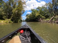
This was the paddle upstream. You can just barely see the shallows starting up in front of us.

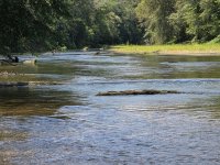
This is what the flow looked like in the shallows. I think it's the fastest thing I've ever paddled solo, I've lead a sheltered life. I've been in higher currents, but always with a larger boat and motor, think south Louisiana floods. I couldn't find any info on flow rate that I thought was accurate, it seems to only be measured at flood stage here. My wife read something about class II rapids on the Bogue Chitto, but I don't know...maybe during a flood stage or during higher flow rates than we experienced that day, but I honestly don't know what constitutes a "class II whitewater section".

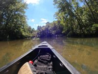
This was down past the put in, around that next turn it got shallow again. It was about 3:30 by this point and we decided to paddle back up and call it a day. We had about an hour drive home after we packed up. You can see wifey up ahead there on her green kayak.

It was a fun day all in all and a good scouting mission. We have already been talking about a shuttle set up with a couple of friends of ours, I think it could be a fun weekend.
Oh and Glenn, I tried some of the paddle techniques you've been posting in the calmer areas of the river. All I can say is I need a lot of practice with a single blade after many moons with a double blade. There was no way I could do that upper, faster part with a single blade yet, I barely kept it together with a double.
I feel a little silly posting this after all the phenomenal trip reports I see on CT.N, you guys throw some EPIC adventures!
Enjoy!
There's plenty of places to paddle around home, but it's all muddy and not moving at all and anything brackish/salty could possibly hold flesh eating bacteria during the summer when water temps are up. Vibrio vulnificus has been on the uptick this year, I think we're up to 4 deaths and 20 infections as of August 13th. NO THANKS. We'll paddle down here this winter after water temps are too cold for Vibrio, but summer is a no go.
After a little research about where we might be able to paddle, we decided to go up to McComb Mississippi to a place called Bogue Chitto Water Park. It was $8/person to get into the park, the park road were paved, there was a nice boat/canoe launch and lots of shaded parking. The Bogue Chitto is one of the cleaner rivers around to paddle, at least up there it is. We got a late start but got to the park about 10am. We had packed a picnic lunch and a few drinks, we threw the cooler in my canoe and set off. I was in my OT 119 and my wife on her kayak. We decided to pull over on a gravel bar and have our lunch before we got to the shallower areas a few turns ahead.
The Bogue Chitto is moving along pretty good that far north and is really moving in the shallow areas. For this part of the river you are typically shuttled upriver the float/paddle back down. Since we only had a short amount of time, we decided to forgo the shuttle and paddle as far up as we could, more or less to check the area out for future (longer) trips. It was easy going and we made good time for the first mile or so, then the river got really shallow. We got to the point that we couldn't get enough of our paddle blades in the water and lost forward momentum. We decided to hop out and wade upriver as far as we could. We lined our boats up another 4 or 5 bends and had to call it quits, it was just too hard wading up against the current and the bank was too overgrown to use that as a way to move upstream.
We swung around and ran the 1/2 mile or so of the "whitewater" (
There are shuttle put in spots at 2 miles, 7 miles and 15 miles up stream, from a local company and if you plan it as a group outing with two or more vehicles, there's even more river to explore. Every highway bridge has a spot to drop in, there's at least another 15 to 18 miles of river that should be navigable looking at the map. There's lots of large sand and gravel bars to camp on, I'm hoping to make an overnight trip out of it next time.
This was the paddle upstream. You can just barely see the shallows starting up in front of us.

This is what the flow looked like in the shallows. I think it's the fastest thing I've ever paddled solo, I've lead a sheltered life.

This was down past the put in, around that next turn it got shallow again. It was about 3:30 by this point and we decided to paddle back up and call it a day. We had about an hour drive home after we packed up. You can see wifey up ahead there on her green kayak.

It was a fun day all in all and a good scouting mission. We have already been talking about a shuttle set up with a couple of friends of ours, I think it could be a fun weekend.
Oh and Glenn, I tried some of the paddle techniques you've been posting in the calmer areas of the river. All I can say is I need a lot of practice with a single blade after many moons with a double blade.
I feel a little silly posting this after all the phenomenal trip reports I see on CT.N, you guys throw some EPIC adventures!
Enjoy!

