- Joined
- Jan 6, 2017
- Messages
- 40
- Reaction score
- 6
July 23, 2018
ATTENTION: Woodland Caribou Provincial Park (WCPP) users and stakeholders
NO ADDITIONAL CLOSURES - same as July 22 post above
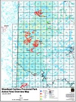
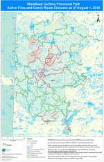
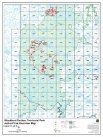
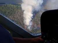
As previously communicated, WCPP and Ontario is under significant fire load. WCPP is experiencing significant smoke activity, which will create poor air quality and reduced visibility.
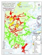
Due to the danger posed by numerous wildfires, canoe routes have been CLOSED. Closed routes are subject to change as threat increases or diminishes. A route closure map may be obtained by contacting the Ontario Park office in Red Lake at (807) 727-1388.
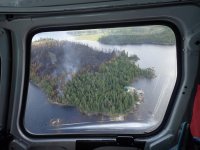
One Outpost Camp to be evacuated morning of July 24/2018 due to fire risk
If you have an Outpost Camp on one of the lakes listed above, Ontario Parks considers these to be at HIGH RISK and accessing these locations is not recommended. Outposts / camp owners on these lakes are NOT restricted at this time
ATTENTION: Woodland Caribou Provincial Park (WCPP) users and stakeholders
NO ADDITIONAL CLOSURES - same as July 22 post above
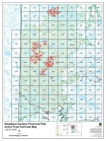
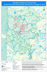
As previously communicated, WCPP and Ontario is under significant fire load. WCPP is experiencing significant smoke activity, which will create poor air quality and reduced visibility.
Due to the danger posed by numerous wildfires, canoe routes have been CLOSED. Closed routes are subject to change as threat increases or diminishes. A route closure map may be obtained by contacting the Ontario Park office in Red Lake at (807) 727-1388.
One Outpost Camp to be evacuated morning of July 24/2018 due to fire risk
If you have an Outpost Camp on one of the lakes listed above, Ontario Parks considers these to be at HIGH RISK and accessing these locations is not recommended. Outposts / camp owners on these lakes are NOT restricted at this time