• Happy International Mermaid Day! 🧜🏼‍♀️

Whitney Wilderness Loop

Joined
Oct 29, 2019
Messages
597
Reaction score
892
Location
southeast PA
The more remote Adirondack trips appeal to me, and I've been thinking of this one for my next (hopefully next week) solo outing with the wood/canvas canoe. Before I'm allowed to go the boss says I have to renew 31 sections of split rail fence, and... I want to fill the new canvas on my project canoe, the Willow 15'.

The river section beyond Lows lower dam doesn't appeal, both for the additional time involved and because it'll probably require a lot of carrying or lining or scraping my precious little canoe! So, what I'm thinking is to start on Little Tupper and travel to Lows Lower Dam where I can leave my truck. I'll probably drop my canoe & gear, drive to the lower dam, then bicycle over to Little Tupper where I'll lock it to a sign or tree. By map, it appears to be a 12 mile bike ride which is certainly do-able (my other hobby is road cycling so 12 miles is no big deal) however it'll be on a beater bike which is slower and I don't care if it's stolen.

So, among you experienced Whitney Wilderness Loopers, is a 3 night itinerary reasonable? Night 1- Rock Pond, Night 2- Lake Lila, Night 3- Lows Lake. I don't know if the recent rains associated with Hurricane Ida made it into the Adirondacks. If so the boggy bits could be real bad. Your thoughts would be welcome.

My next option is the St. Regis Canoe Area, perhaps with a focus on some of the smaller ponds... Pink Pond, Ledge Pond, Mountain Pond from Long Pond and perhaps a hike of Long Pond Mountain.

Pat
 
Patrick I have done a part of that loop. Night 1 is easy. I have not done the part through Hardigan Pond to Lila with the portages around Hardigan and Shingle Shanty ( the ruling was not in paddlers favor) but I have not heard of anyone camping in there either so it should be quite doable. I did Lila to Lows in one night and one portage was a blind wade in the grass and step on grass horror along Harrington Brook. The railroad part annoying as the ties did not match my stride ; the last part of the 1.25 miles easy. There is one more short portage then you land on Lila but there is a good 10 mile paddle and one more port out. This could be a very long day but the water at the end of the day has one channel so you should be able to find your way even as dark falls. Having your truck at the end is the best idea. The beginning at LTL is at the ranger station so there should be no tomfoolery with your bike especially if you mention it to a ranger. Consider just camping at Hitchins pond if the hour gets too late and get to your truck early in the AM day 4
 
I can't find my paddler's map, but I've done the whole loop and several versions of it. Enough to know that three days as you describe is doable. My first time doing the whole loop I stayed at Rock pond, then Lila, then Lows. It definitely could be sloppy from Rock pond over to the Shingle Shanty Carry. The mud at the Hardigan Pond carry (first one out of Rock Pond) is legendary. I'm six foot and have sunk to my waist in an instant. My understanding is that that carry moved a few hundred yards North to drier land but you would need to confirm that with Raquette River Outfitters or maybe the Ranger Station. If you could add one more day as Yellowcanoe mentions you could check out a lot more of the area.

The mud slog carry (Hardigan Pond Carry):
P5030057 by Barry Rains, on Flickr

Drier section of the Hardigan Pond Carry:
P5040099 by Barry Rains, on Flickr

The Rail Road Carry to Clear Pond doesn't fit my stride either, but I've seen a fair amount of moose track along the tracks so keep an eye out:
P5050170 by Barry Rains, on Flickr

The tracks aren't active, but I've seen Rail road trucks running on it so if you double carry keep your kit off the tracks!:
P9300369 by Barry Rains, on Flickr

Nice beach camping on Lila (first campsite at shingle shanty outlet to Lila):
P9300320 by Barry Rains, on Flickr

I plan on doing the whole loop again during the third week of October but there was work on the Lower Dam that may mean low water on the bog river so I may finish with Low's as well.

Cheers,
Barry
 
Last edited:
I recall one guy on this site years ago, maybe still here, saying he did in one day with a very light boat and all single carries. He wasn't recommending that for others, of course.
 
Patrick,
I did LTL to Lila with my then 14 year old son, late start on a Friday(due to the 7 mile bike shuttle), packed the car to leave Lila on Saturday evening. Spent the night on the island on Rock Pond...this was before the flooding of the Rock to Hardigan section. I particularly liked Salmon Lake Outlet.

I did Lila to Lows with the guys (son included), again, a slightly late start on Lila (for the car shuttle), so mid morning on a Friday at the Lila put in, and we stayed on Lows that night. Spent the next day diddling around on Grass Pond Mt, then moved farther down Lows, to site 10, I think. Paddled out on Sunday with plenty of time for a meal on the way home. The carry from Lila to Harrington Brook is rough, same as it's been for years...

So 3 nights is entirely doable, especially if you're traveling solo. If it were me, I would add a day for a Grass Pond Mt scramble, the views are excellent and colors could be nice.
 
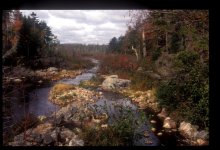
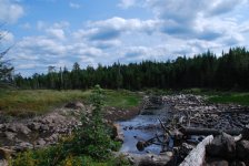
After posting my reply above, and then seeing Waterdog's photos, I do believe that slogfest at the start of the Hardigan carry was navigable when my son and I traveled through there. The old road that crosses Rock Pond outlet used to hold back quite a bit of water...When last I passed through there (3 years ago??), that section of road is long since washed out, and the water level on Rock must have dropped accordingly.10-98_24.jpg


DSC_5261.JPG

Upper pic is from 1998, lower pic from 2015...vantage point is nearly the same, looking upstream from where the Rock Pond Trail (formerly a road) crosses Rock Pond Outlet. While it appears to be only a few inches of water, I believe that's all it took to allow paddling (rather than slogging) to the start of the Hardigan carry.DSCF1274.JPG

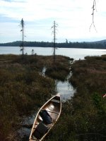
OK, last edit, I swear...I dug up this photo from the through trip with my son, the year was 2004, and this is the start of the carry to Hardigan, looking back towards Rock Pond. As I remember, it was a bit of bouncing and poling to get our boat as far as you see it in the pic. A few inches less water, and it would have been (or is?) a slogfest for 50 yards!!
 
Last edited:
Back
Top