I’ve paddled many of the adventurous stretches of the Potomac, mostly stretches with rapids, but that leaves a whole lot of river I’ve never seen. Weather and my schedule recently provided a short opportunity, so I went to Cumberland, MD to paddle. I had previously paddled Old Town to Hancock, so this trip was new water for me.
I often read TRs on Canoetripping of fabulous trips by canoeists who go into the wilderness for weeks and paddle impressive mileage. I spent two days on Cumberland to Town Creek, which is only 22 miles. Certainly not an epic trip. Yet I was illogically excited when I launched from Mason Park. It felt so good to be on the water.
I wanted to launch in Cumberland proper, but couldn’t find a launch. Mason Park is perhaps a mile downstream of the City but provided a nice boat ramp and parking area. The ramp has red/yellow/green stripes, I think. Only the top of the red was showing—the river was running about four feet above canoe-zero, so the current was pumping. Note: shortly after my trip western Maryland experienced flooding rains that raised the level another ten feet. Have pity for the flood victims.
Almost immediately after launching, I noticed an unusual hillside on river right--blackish rock neatly arranged in tiers with very little vegetation. I wondered if it was a restored strip mine, but can't find any info on it. Landfill? You can see it from the satellite view just to the east of runway 23 at Greater Cumberland Regional Airport. Please let me know if you recognize what this odd hillside is.

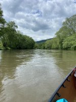
I think this stretch has some C1 Rapids and riffles, but with the gage around 7', any that were there were underwater. Occasionally, I’d hear the sound of churning waves and get a little tingle of excitement, thinking a rapid was coming up. Most often, it was the sound of the current making waves on a downed tree. The river is wide enough that I wasn’t too worried about river-wide strainers, and in fact I did not encounter any, but still, the churning sound produced a tingle of excitement.

I made it to Spring Gap in under 3 hours. I had stashed my bike there, and was soon peddling west on the C&O towpath. What a glorious way to run shuttle—temp in the 70s and flora in spring bloom. The canal cut across some of the river’s bends, so I was not always riding along the river. But, for a lot of the ride I could look down to the river on my left and admire the scenery where I had just paddled. A nice ride to conclude the outing.

I camped at Spring Gap, where a bicyclist friend was also camped. In the morning, my friend shuttled my vehicle to Paw Paw. It was a long drive to Paw Paw and I became concerned I was biting off too much river. Usually, the river has many bends so the river miles are greater than the shuttle miles. On the way back to Spring Gap we checked out a landing at Town Creek Aquaduct and I decided I’d take out there.
A group from Westtown School had arrived at Spring Gap. They had 24 tandem canoes and a half dozen safety kayakers. The launch was crowded with their boats and a throng of kids as I dropped off my boat prior to the shuttle drive. They were still there an hour later when we came back, and they were still there when I launched. I had pleasant solitude on the river until I stopped for lunch at an unusual grassy area, complete with tables. Most of the river banks are crowded with trees, bushes and shiggy, so this park-like area was unusual. It appeared to be private, but was not posted with no trespassing signs as might be expected. I was finishing up my lunch when I heard the kids coming. As I shoved off I told the kids I felt sorry for them being out on the river when I knew they’d rather be in a classroom back in West Chester. That drew a laugh from the kids.
The guides of the Westown group told me the low-water bridge at Old Town was runnable up to 8’. The gage was dropping from 7’, so I was surprised at how little space there was under the bridge. I approached cautiously and then had to lay down in the boat to fit under the bridge. At 8' the water must be to the top of the passages.

A mile or two downriver from Old Town the South Branch of the Potomac enters on the right, and the river promptly widens to about twice as wide. There wasn’t a lot of water flowing out of the South Branch, so the speed of the current was about cut in half, but was still moving along smartly. Logs and a few rocks protruded from the river here and there. One or two even had surfable eddies, although I didn’t. There were a few riffles, one with waves all the way up to ten inches! It was a lovely day trip with very good scenery. Once again, I felt excited and lucky to be on the river this day. I reached Town Creek about 2:45 and had just finished hauling gear up over the Aquaduct when my ride showed up.
It would not have been hard to continue on to Paw Paw, which I estimate was 6 or 7 additional miles. With good current and fair winds, I could have just sat in the boat and the river would have carried me there. However, it’s still early in the season and I’m trying to ease into things and avoid elbow tendinitis, which I’ve had problems with in the past. So, I was satisfied to call it a day after 12 miles.
So, I was very happy to fill in this gap in my Potomac paddling experiences. Next, I'd like to paddle from Hancock to Dam 3, another section where I've never been. There is another 36 miles of river upstream from Cumberland, starting at Bloomington. There are rapids and dams that make those sections problematic, and I don't at this time have any desire to paddle those miles. The whitewater section from Barnum to Bloomington I've paddled several times. The Hancock to Dam 3 section has the C&O Canal National Historic Park along the Maryland side, meaning there are camp sites and the bike trail along the stretch, so it is logistically easier to pull off a trip. I'm looking for good weather to align with my calendar so I can get out to Hancock and get started.
I often read TRs on Canoetripping of fabulous trips by canoeists who go into the wilderness for weeks and paddle impressive mileage. I spent two days on Cumberland to Town Creek, which is only 22 miles. Certainly not an epic trip. Yet I was illogically excited when I launched from Mason Park. It felt so good to be on the water.
I wanted to launch in Cumberland proper, but couldn’t find a launch. Mason Park is perhaps a mile downstream of the City but provided a nice boat ramp and parking area. The ramp has red/yellow/green stripes, I think. Only the top of the red was showing—the river was running about four feet above canoe-zero, so the current was pumping. Note: shortly after my trip western Maryland experienced flooding rains that raised the level another ten feet. Have pity for the flood victims.
Almost immediately after launching, I noticed an unusual hillside on river right--blackish rock neatly arranged in tiers with very little vegetation. I wondered if it was a restored strip mine, but can't find any info on it. Landfill? You can see it from the satellite view just to the east of runway 23 at Greater Cumberland Regional Airport. Please let me know if you recognize what this odd hillside is.
I think this stretch has some C1 Rapids and riffles, but with the gage around 7', any that were there were underwater. Occasionally, I’d hear the sound of churning waves and get a little tingle of excitement, thinking a rapid was coming up. Most often, it was the sound of the current making waves on a downed tree. The river is wide enough that I wasn’t too worried about river-wide strainers, and in fact I did not encounter any, but still, the churning sound produced a tingle of excitement.
I made it to Spring Gap in under 3 hours. I had stashed my bike there, and was soon peddling west on the C&O towpath. What a glorious way to run shuttle—temp in the 70s and flora in spring bloom. The canal cut across some of the river’s bends, so I was not always riding along the river. But, for a lot of the ride I could look down to the river on my left and admire the scenery where I had just paddled. A nice ride to conclude the outing.
I camped at Spring Gap, where a bicyclist friend was also camped. In the morning, my friend shuttled my vehicle to Paw Paw. It was a long drive to Paw Paw and I became concerned I was biting off too much river. Usually, the river has many bends so the river miles are greater than the shuttle miles. On the way back to Spring Gap we checked out a landing at Town Creek Aquaduct and I decided I’d take out there.
A group from Westtown School had arrived at Spring Gap. They had 24 tandem canoes and a half dozen safety kayakers. The launch was crowded with their boats and a throng of kids as I dropped off my boat prior to the shuttle drive. They were still there an hour later when we came back, and they were still there when I launched. I had pleasant solitude on the river until I stopped for lunch at an unusual grassy area, complete with tables. Most of the river banks are crowded with trees, bushes and shiggy, so this park-like area was unusual. It appeared to be private, but was not posted with no trespassing signs as might be expected. I was finishing up my lunch when I heard the kids coming. As I shoved off I told the kids I felt sorry for them being out on the river when I knew they’d rather be in a classroom back in West Chester. That drew a laugh from the kids.
The guides of the Westown group told me the low-water bridge at Old Town was runnable up to 8’. The gage was dropping from 7’, so I was surprised at how little space there was under the bridge. I approached cautiously and then had to lay down in the boat to fit under the bridge. At 8' the water must be to the top of the passages.
A mile or two downriver from Old Town the South Branch of the Potomac enters on the right, and the river promptly widens to about twice as wide. There wasn’t a lot of water flowing out of the South Branch, so the speed of the current was about cut in half, but was still moving along smartly. Logs and a few rocks protruded from the river here and there. One or two even had surfable eddies, although I didn’t. There were a few riffles, one with waves all the way up to ten inches! It was a lovely day trip with very good scenery. Once again, I felt excited and lucky to be on the river this day. I reached Town Creek about 2:45 and had just finished hauling gear up over the Aquaduct when my ride showed up.
It would not have been hard to continue on to Paw Paw, which I estimate was 6 or 7 additional miles. With good current and fair winds, I could have just sat in the boat and the river would have carried me there. However, it’s still early in the season and I’m trying to ease into things and avoid elbow tendinitis, which I’ve had problems with in the past. So, I was satisfied to call it a day after 12 miles.
So, I was very happy to fill in this gap in my Potomac paddling experiences. Next, I'd like to paddle from Hancock to Dam 3, another section where I've never been. There is another 36 miles of river upstream from Cumberland, starting at Bloomington. There are rapids and dams that make those sections problematic, and I don't at this time have any desire to paddle those miles. The whitewater section from Barnum to Bloomington I've paddled several times. The Hancock to Dam 3 section has the C&O Canal National Historic Park along the Maryland side, meaning there are camp sites and the bike trail along the stretch, so it is logistically easier to pull off a trip. I'm looking for good weather to align with my calendar so I can get out to Hancock and get started.