I get a lot of requests for these maps every year, mostly from another canoe site, so I thought I would just post them and be done with it…an on-line reference. The Steel is a non-maintained waterway park in Northern Ontario. The north end of the loop is close to Longlac, and a mere 80 kilometres from my house. The south end of the loop is east of Terrace bay. Most people start from the south end, but my maps start from the north end, primarily because it is closer, and also because doing Diablo portage on the first day can be daunting.
Steel Lake/River Loop
Map 1
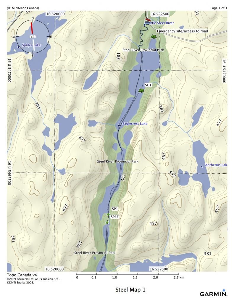
From the town of Longlac, drive 50 kilometers south on the Catlonite Road. Turn left on Sun Road South and proceed 3 kilometers down the road to a bridge. This is your departure point and your parking spot for the loop trip.
All GPS coordinates are in NAD 27
16 U 522217 5471223 Start Point
You will proceed down a small twisty creek that runs into Eaglecrest Lake. If you have arrived late, or have extra time to spend, the campsite indicated by SC1 is one of the nicest sites in Northern Ontario.
SC1 16 U 522075 5469517
Continue on south on Eaglecrest and you will reach the first portage, indicated as SP1. This is a scenic port of around 200 meters on river right. It goes around some shallow rapids.
SP1 16 U 521296 5466498
Map 2
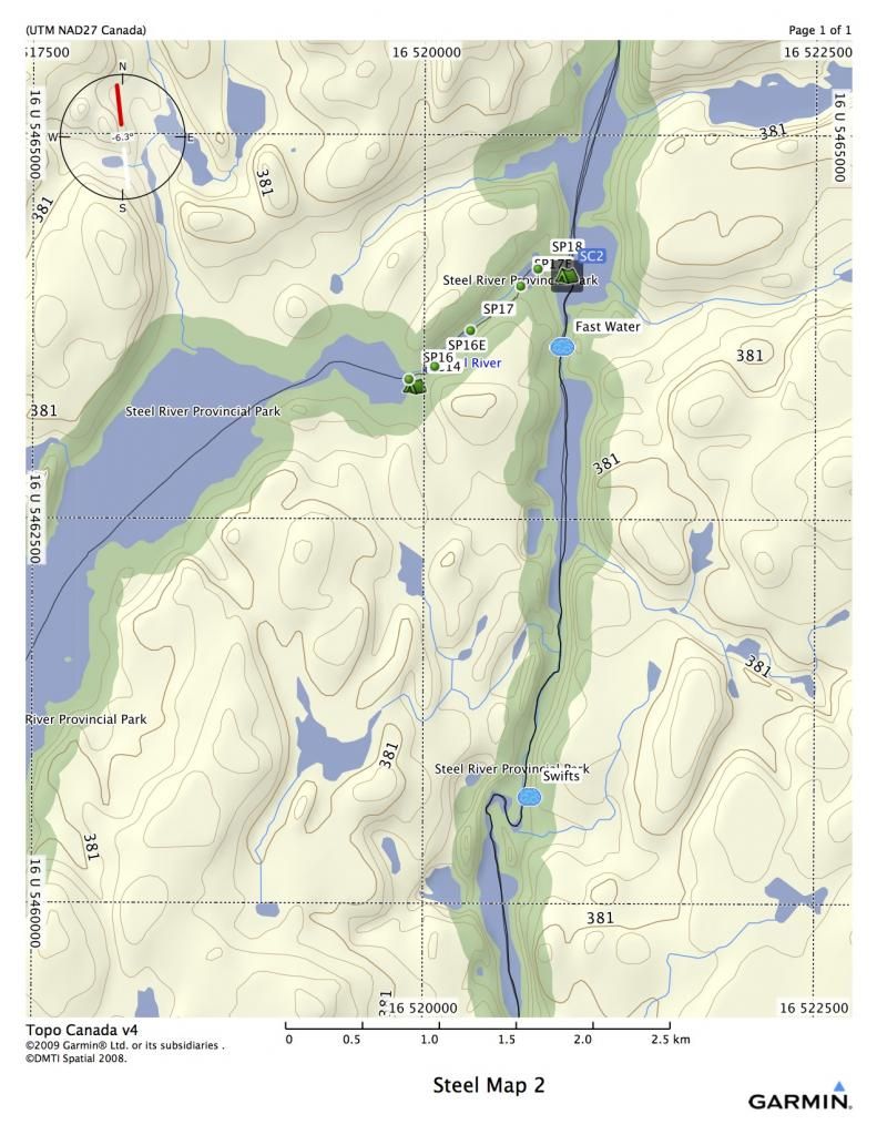
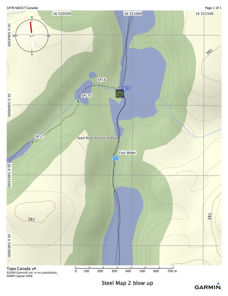
There is a very nice campsite located at SC2 (see blow up map). Once you leave this site, you are into the river proper, and you will quickly experience fast water and swifts. At high water, they might develop into C1’s, at low water you might have to walk a few of them.
SC2 16 U 520911 5464082
Map 3
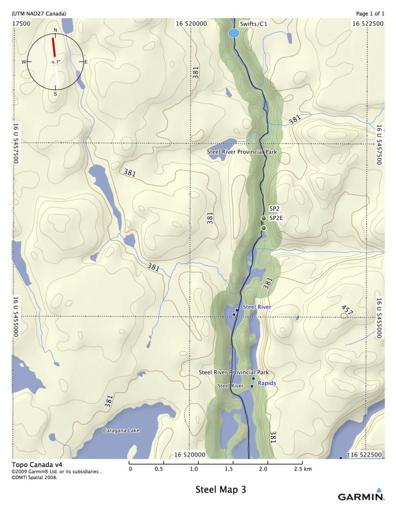
More swifts, and a set of rapids. The rapids are fairly straight foreward until you reach the bottom, where they turn into a boulder garden. If the water is high, you can probably bounce over the bottom. If the water is low, there is a port on River Left, or you can line it on RL.
SP2 16 U 521044 5456432
Map 4
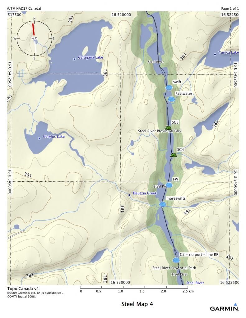
Lots of swifts and fast water on this map. Good fishing at the bottom of all the little rapids. SC3 is a very picturesque campsite located directly across from a sheer cliff face. SC4 is also very nice, with some plywood tables and stuff. Located in a large cedar forest, with a steep beach. The rapid at the bottom of the map can be problematic. (They are incorrectly labeled C2) It is difficult to run, unless the water is very high, and there is no port. Best approach is to line down RR until you can hop in and shoot the haystacks at the end.
SC3 16 U 521089 5451257
SC4 16 U 521213 5450623
Map 5
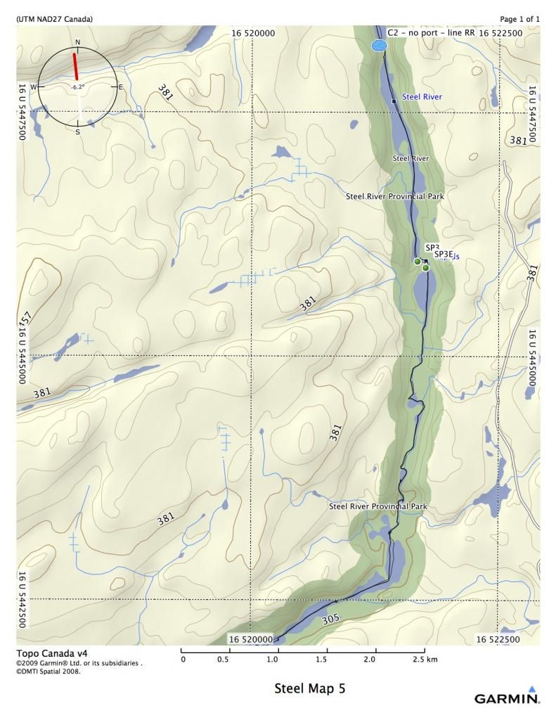
Port SP3 is located RR, and is 140 meters long. It goes up a steep hill and goes around a rocky set of rapids. At high water, they can be fairly easily shot, although there is a right angle turn. At low water, you might be able to bump a canoe through, but it becomes quite a boulder garden.
SP3 16 U 521678 5445983
Map 6
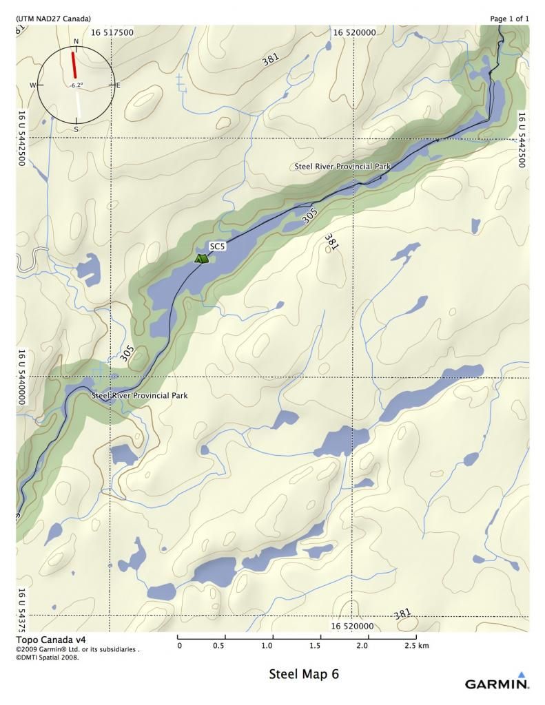
SC5 is a very nice campsite, located on a point in back of an island. It is suitable for a couple of tents.
SC5 16 U 518443 5441236
Map 7
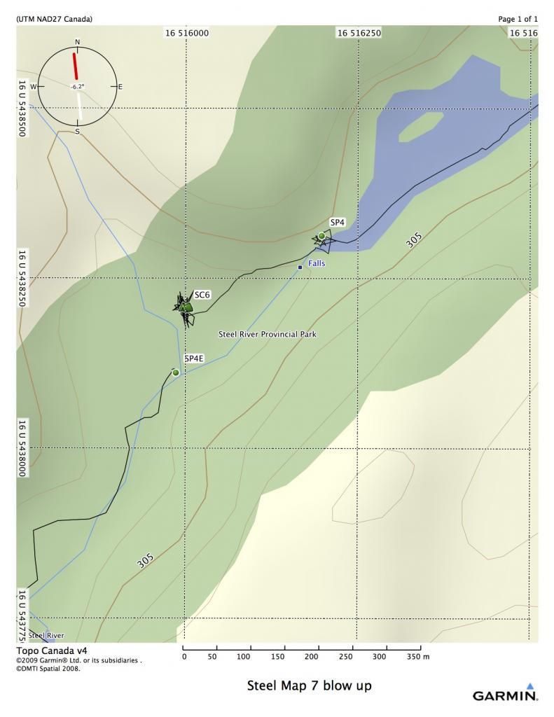
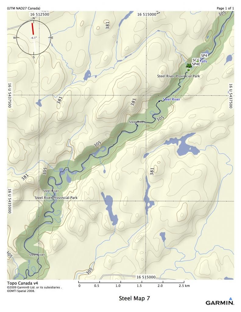
You will hit one of the highlights of the trip on this map, Rainbow Falls. This is a very large falls. The port is RR, don’t miss it, and is approximately 330 meters long. 2/3’s of the way down the port, there is a very large camping site, suitable for many tents. There is fast water both before and after the falls. The Deadhorse Bridge over the river is a two hour paddle from the falls. This is your last chance to get out to civilization before Santoy Lake, although it is approximately 40 kilometers from the bridge to Highway 11. Vehicle traffic is infrequent on the road.
SP4 16 U 516199 5438314
SC6 16 U 516002 5438207
Map 8
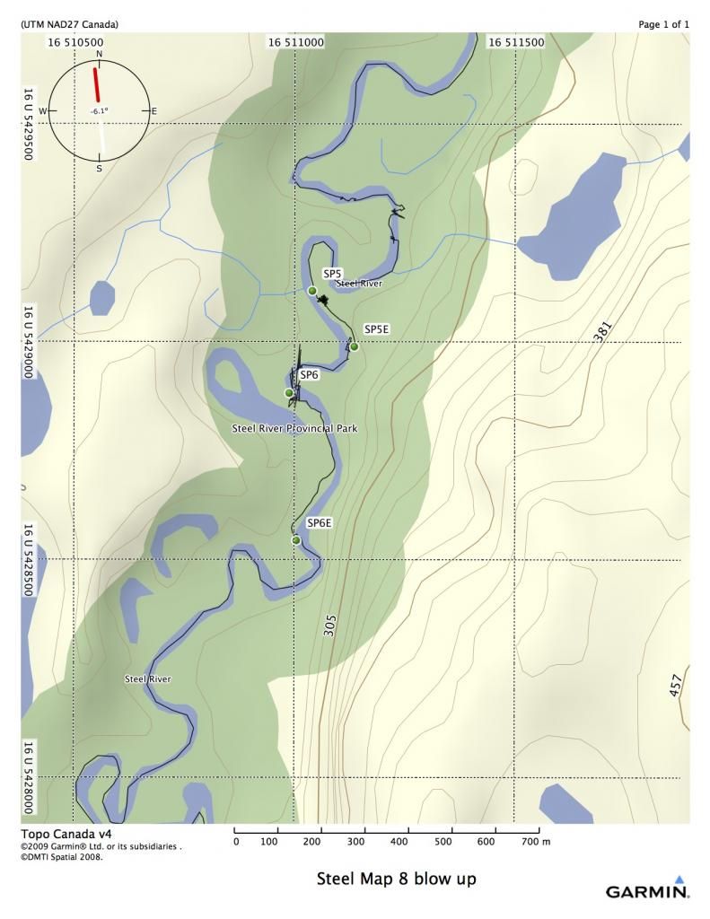
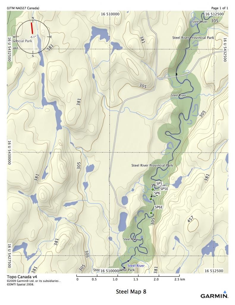
Once past the Deadhorse Bridge, the nature of the river changes greatly. The swifts give way to countless meanders, and as a result, log jams. There are four major log jams that often move around and change. Sometimes new ones develop, and old ones are swept away. So be ready for anything…the map is a rough approximation at this point.
SP5 has been in that general area for quite a few years, although the beginning keeps getting pushed further downstream. It is around 160 meter, on RL. The entrance and exit for all the log jam ports usually involve some inventive climbing up very steep banks.
SP5 16 U 511042 5429118
SP6 has been in that general area for quite a while too. It is on RR. There was an excellent port on RL too, but it hasn’t been used I many years, so has probably disappeared. SP6 is around 600 meters, although, it fluctuates up to 800 meters.
SP6 16 U 510990 5428886
Map 9
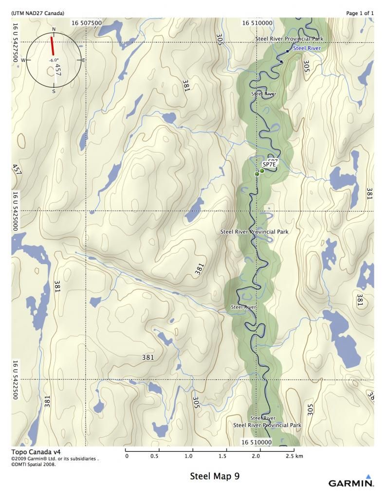
Lots of meanders and wildlife sightings in store. The logjam at SP7 has diminished to half the size it used to be. If you paddle to RL and follow through a series of sand bars and log, you should see a steep trail leading up to the bush. The port is here, and it is only about 100 meters long now.
SP7 16 U 510087 5425605
Map 10
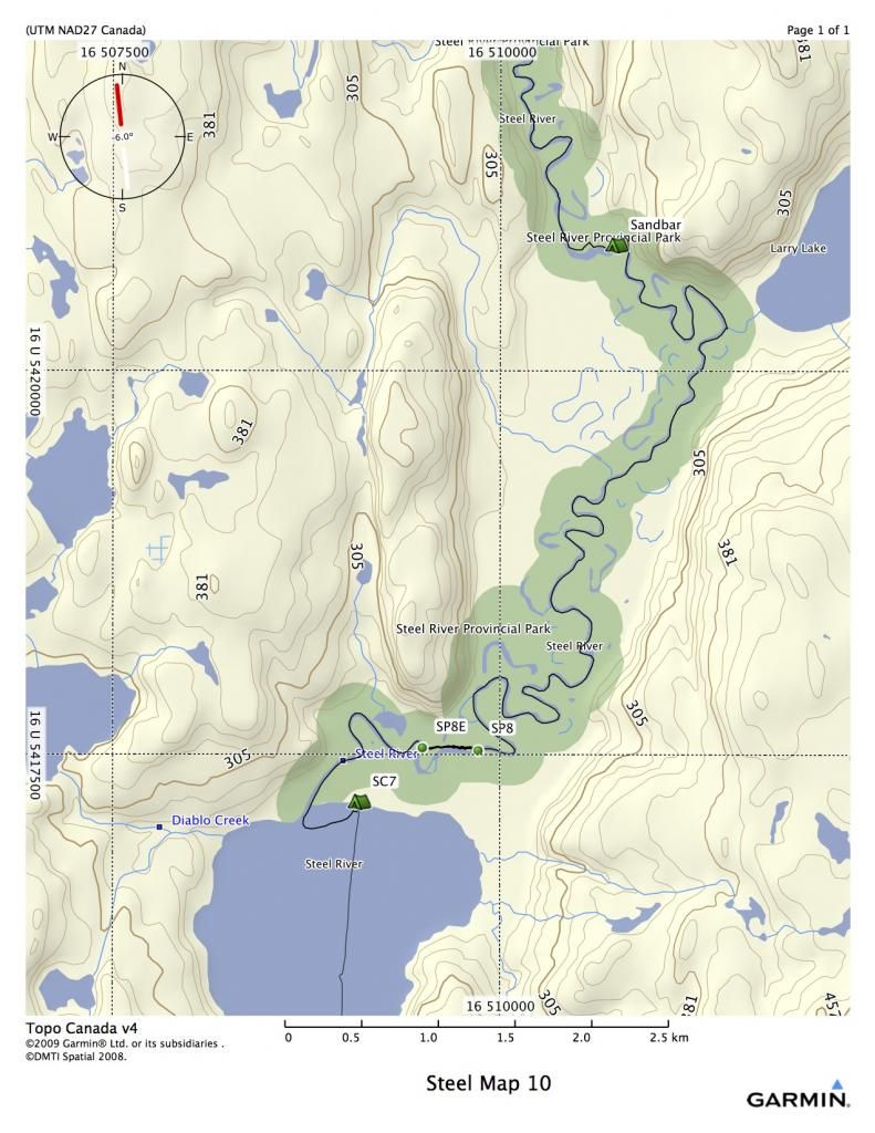
Many people travel from Rainbow Falls to Santoy Lake in one day, but it is a very long day. The reason for this is because campsites are far and few on the stretch below the bridge. However, there are numerous sandspits that can hold up to three or four tents, depending on water levels. These will be your only options if you want to break it up into two days. The last log jam is massive, but the port is used by fishermen. However, unloading your gear will be a struggle, as the banks are steep and the water deep.
SP8 is RR and 350 meters long through a cedar forest.
Around an hour of paddling will get you to the north end of Santoy Lake, which is a huge beach, with many camping opportunities.
SP8 16 U 509863 5417541
Map 11
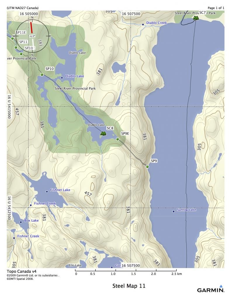
It’s approximately four kilometers from the beach on the north end of Santoy to Diablo Port. Diablo has a reputation for being one of the hardest portages in Northern Ontario. The first four hundred meters is a series of switchbacks with some almost vertical climbs. It is very tough. However, the one thing about Diablo is that when you think it can’t get any worse, it does. There is a narrow rocky chasm close to the end that will try the most hardened canoeist. My GPS reads the port at about 1.2 k, but it feels much longer.
SP9 16 U 507920 5413529
SC8 16 U 506839 5414335
Most people will camp on the small island just west of the port. It is a good site, and you will probably be tired after the arduous trek.
SP10is at the Northwest end of the Lake. This port is 800 meters, with rolling terrain. It has a couple of wet spots, but is mostly dry. It ends in a swamp, where launching may prove difficult, depending on water levels.
SP10 16 U 505338 5415800
SP11 is approximately 350 m long. It ends in a beaver pond. The water level of the launch depends on the activity of the beavers. Sometimes you can launch fairly easily, other times it’s an adventure in loon crap.
SP11 16 U 504693 5416463
Map 12
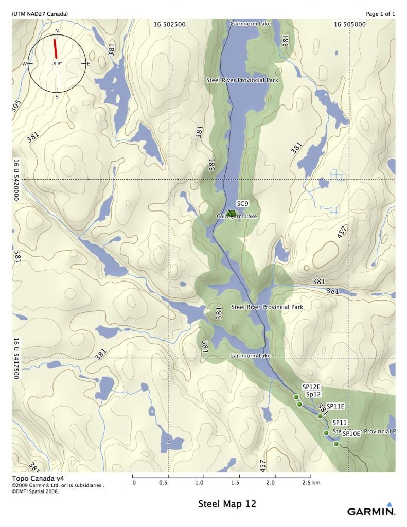
SP12 is a short port of 130 meters. The launch at the end is dependent on beaver activity as well. The last time I was through, in 2011, it was fairly difficult due to recent beaver activity.
SP11 16 U 504324 5416862
Cairngorm Lake is beautiful, and there are a few rock outcroppings you can camp on at the south end. However, the established site at the south end is at the last point on the east before the lake widens. Most people will continue on down the lake to a very nice site shown on map 13.
SC9 16 U 503364 5419531
Map 13
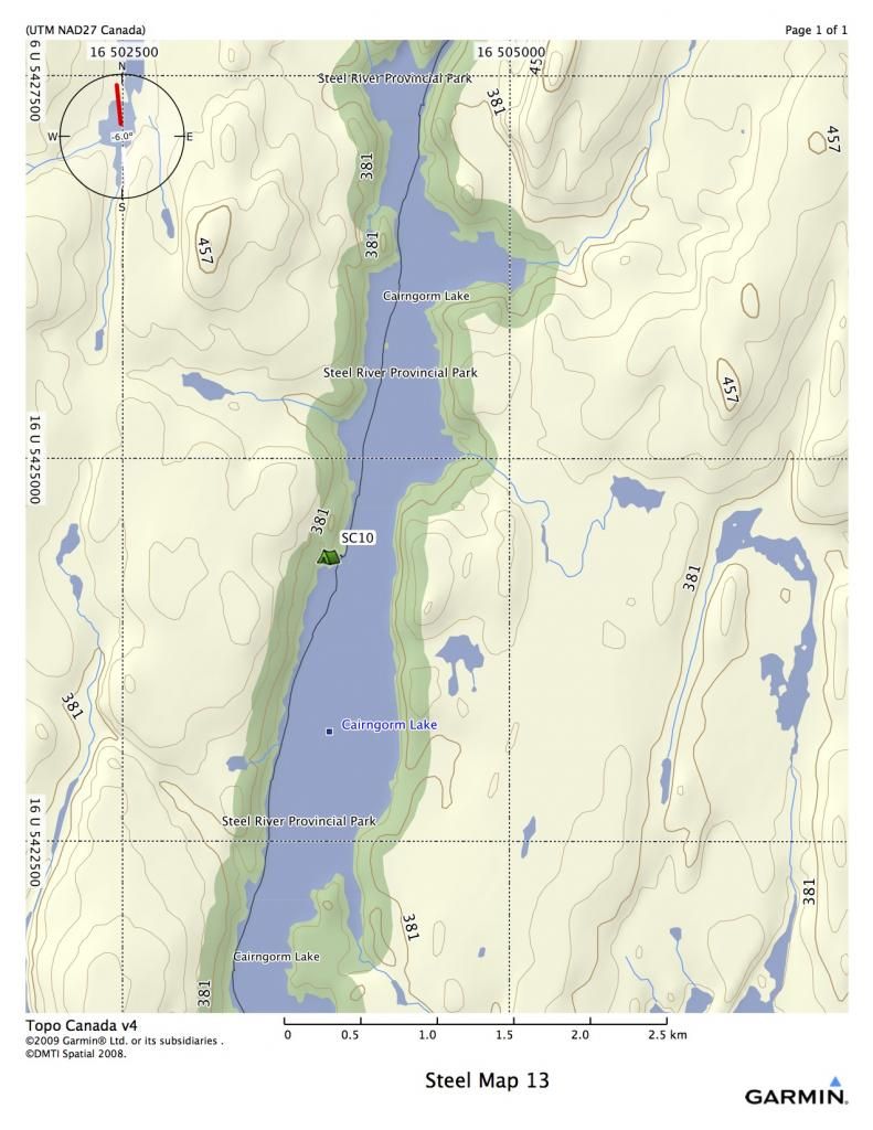
One of the nicest campsites on the trip is on the west shore of Cairngorm. There is a beautiful gravel beach and a nice campsite up the hill on the right. This would be a great place for a rest day.
SC10 16 U 503833 5424351
Map 14
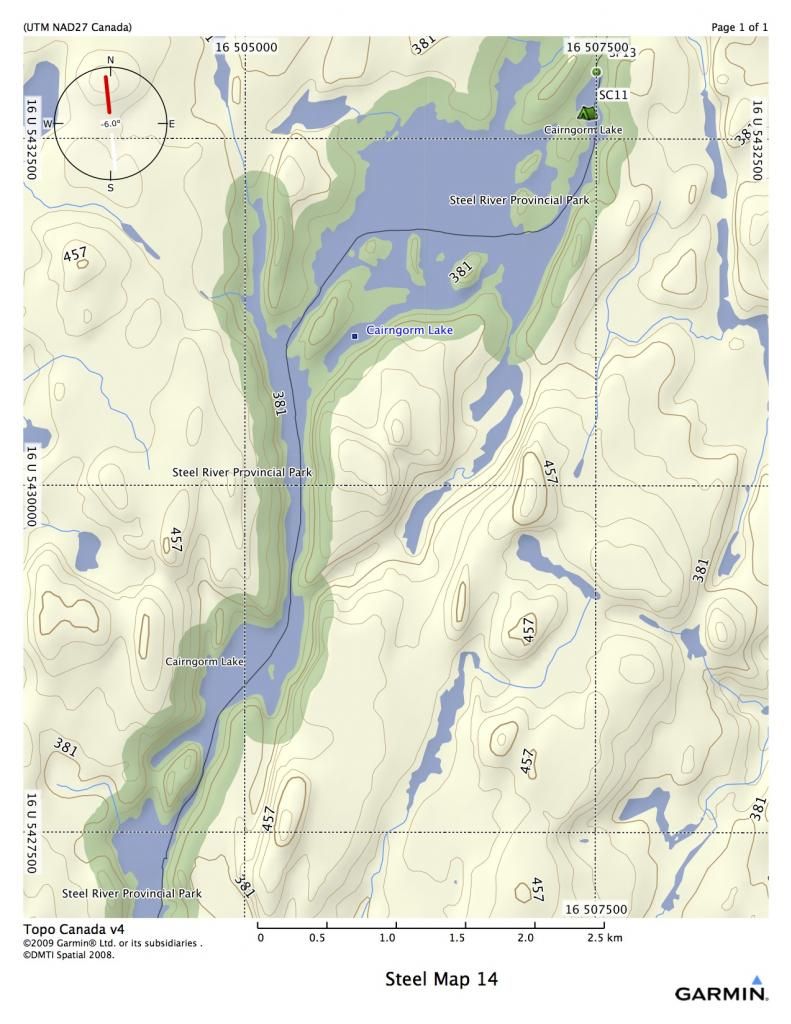
You will be entering an area that was burned in a forest fire a few years ago. The north end of Cairngorm was a very beautiful place, but it is now fairly desolate. There is a very small island (SC11) just before port SP13 that is a good emergency campsite. It has enough room on it for one or two tents.
SC11 16 U 507438 5432687
SP13 16 U 507510 5432992
Map 15
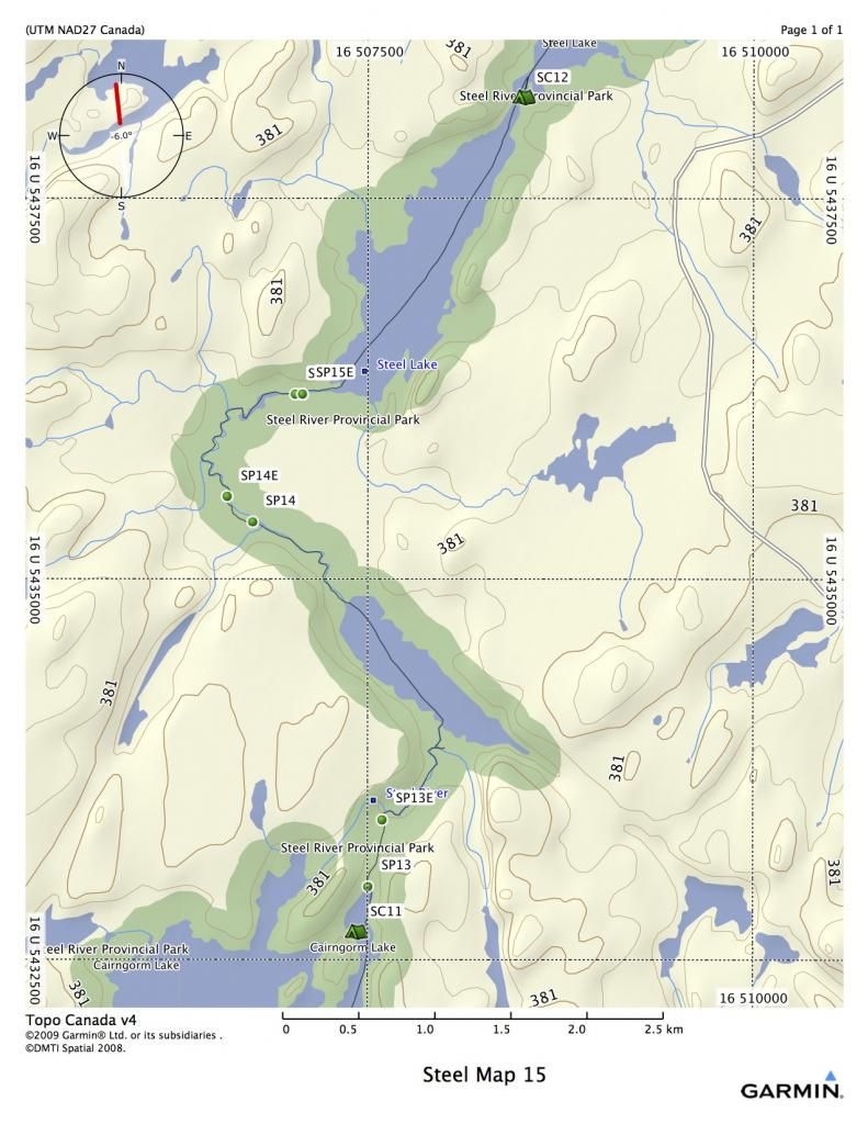
Port SP13 makes its way through a burnover, and is approx 500 meters long. There is a fair amount of new growth, but the trail is evident. The creek that leads out of the end of the port to the small un-named lake north east if the port (sometimes known as Moose Lake) is often too low to paddle and must be dragged, or at very low water, ported. However, in 2011, beavers had constructed a series of dams all the way to the lake, making it an easy paddle.
SP14 goes around a set of rapids on RL and a bridge that was put in during one of the fires. It is a steep port on both sides of the bridge, but not very long. Expect a loon crapty landing at the beginning. It is approx 300 m long.
You will continue to meander through shallow water until you get to the last port before Steel Lake. In high water, I have run this little rapid, but a beaver dam in 2011 had it completely dried up. It is a very short port, RR, approx 50 m.
SP13 16 U 507510 5432992
SP14 16 U 506757 5435384
SP 15 16 U 507030 5436220
Map 16
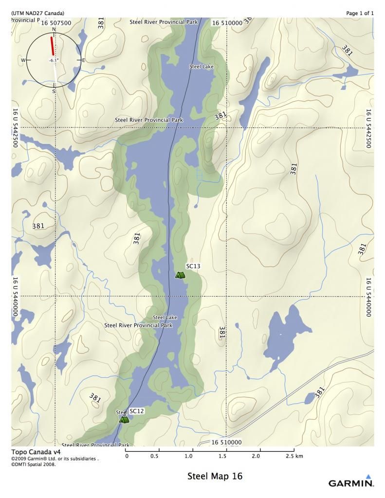
At the first narrows on the Steel, there is an adequate beach campsite if you are in need of stopping. However, there is a large beach site another few kilometers up the lake on the east shore. Steel Lake is around 30 K long, and is usually friendly with winds, but it never hurts to tackle it early in the morning.
SP 12 16 U 508510 5438166
SP13 16 U 509333 5440315
MAP 17
Keep paddling….
MAP 18
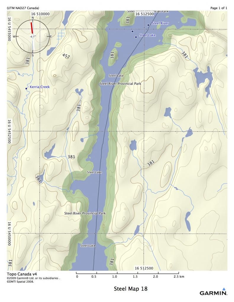
Keep paddling….
MAP 19
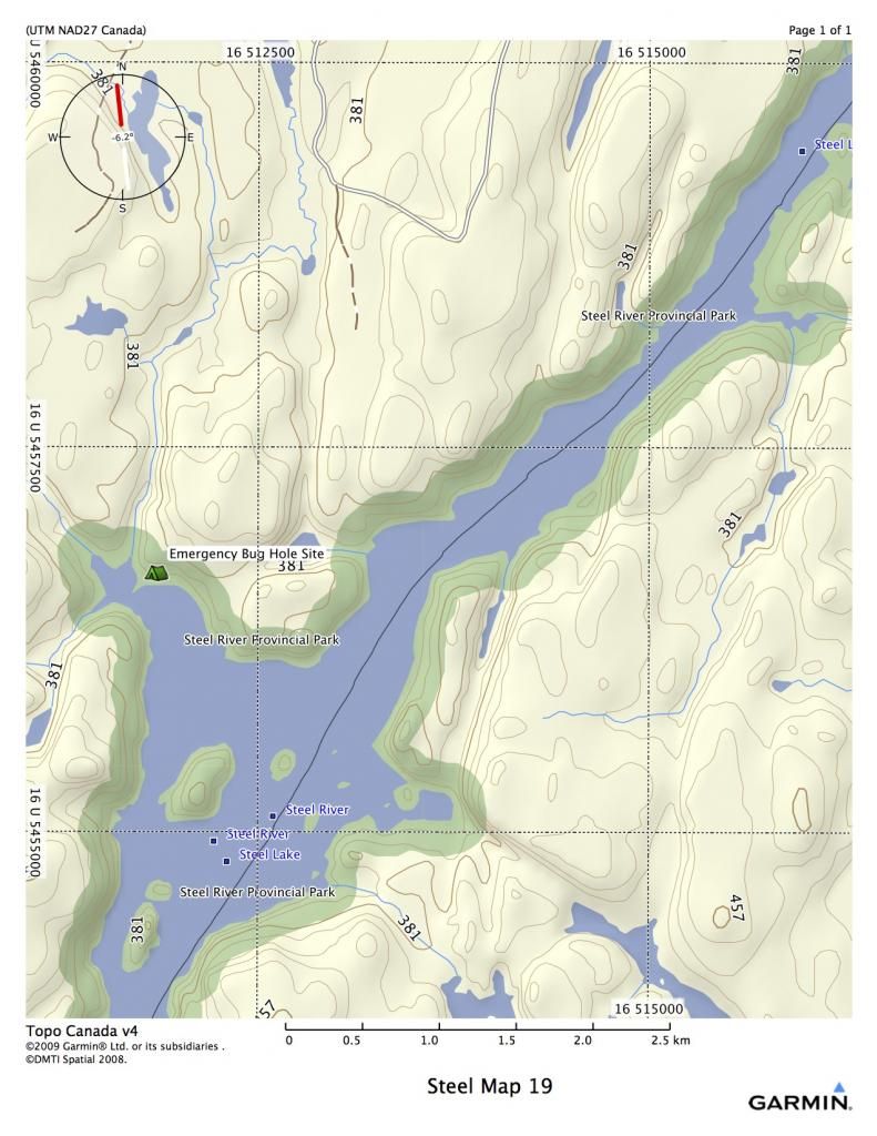
Emergency Campsite 16 U 511850 5456675
MAP 20
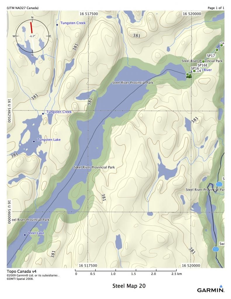
See expanded view on 21.
Map 21
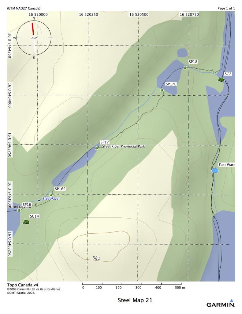
SP 16 starts on a rock face at the far east end of the last bay of Steel Lake. It is on RR and is 200 meters long. There is a nice campsite here, SC14, right beside a waterfall. A short paddle across a little pond will bring you to SP 17 on RR. SP 17 cuts across a ridge through a burnover, and has a couple of treacherous spots that have washed out. It is approx 600 m long. Another short paddle across a little pond will bring you to SP 18, again on RR. If the water is high enough, the rapids can be run, if it is low enough, you might be able walk them on RL. The port is around 160 m, and ends at campsite SC2. From here, you retrace your path north to exit where you began the trip.
SC14 16 U 519948 5463361
SP16 16 U 519911 5463420
SP17 16 U 520296 5463736
SP18 16 U 520733 5464142
Steel Lake/River Loop
Map 1

From the town of Longlac, drive 50 kilometers south on the Catlonite Road. Turn left on Sun Road South and proceed 3 kilometers down the road to a bridge. This is your departure point and your parking spot for the loop trip.
All GPS coordinates are in NAD 27
16 U 522217 5471223 Start Point
You will proceed down a small twisty creek that runs into Eaglecrest Lake. If you have arrived late, or have extra time to spend, the campsite indicated by SC1 is one of the nicest sites in Northern Ontario.
SC1 16 U 522075 5469517
Continue on south on Eaglecrest and you will reach the first portage, indicated as SP1. This is a scenic port of around 200 meters on river right. It goes around some shallow rapids.
SP1 16 U 521296 5466498
Map 2


There is a very nice campsite located at SC2 (see blow up map). Once you leave this site, you are into the river proper, and you will quickly experience fast water and swifts. At high water, they might develop into C1’s, at low water you might have to walk a few of them.
SC2 16 U 520911 5464082
Map 3

More swifts, and a set of rapids. The rapids are fairly straight foreward until you reach the bottom, where they turn into a boulder garden. If the water is high, you can probably bounce over the bottom. If the water is low, there is a port on River Left, or you can line it on RL.
SP2 16 U 521044 5456432
Map 4

Lots of swifts and fast water on this map. Good fishing at the bottom of all the little rapids. SC3 is a very picturesque campsite located directly across from a sheer cliff face. SC4 is also very nice, with some plywood tables and stuff. Located in a large cedar forest, with a steep beach. The rapid at the bottom of the map can be problematic. (They are incorrectly labeled C2) It is difficult to run, unless the water is very high, and there is no port. Best approach is to line down RR until you can hop in and shoot the haystacks at the end.
SC3 16 U 521089 5451257
SC4 16 U 521213 5450623
Map 5

Port SP3 is located RR, and is 140 meters long. It goes up a steep hill and goes around a rocky set of rapids. At high water, they can be fairly easily shot, although there is a right angle turn. At low water, you might be able to bump a canoe through, but it becomes quite a boulder garden.
SP3 16 U 521678 5445983
Map 6

SC5 is a very nice campsite, located on a point in back of an island. It is suitable for a couple of tents.
SC5 16 U 518443 5441236
Map 7


You will hit one of the highlights of the trip on this map, Rainbow Falls. This is a very large falls. The port is RR, don’t miss it, and is approximately 330 meters long. 2/3’s of the way down the port, there is a very large camping site, suitable for many tents. There is fast water both before and after the falls. The Deadhorse Bridge over the river is a two hour paddle from the falls. This is your last chance to get out to civilization before Santoy Lake, although it is approximately 40 kilometers from the bridge to Highway 11. Vehicle traffic is infrequent on the road.
SP4 16 U 516199 5438314
SC6 16 U 516002 5438207
Map 8


Once past the Deadhorse Bridge, the nature of the river changes greatly. The swifts give way to countless meanders, and as a result, log jams. There are four major log jams that often move around and change. Sometimes new ones develop, and old ones are swept away. So be ready for anything…the map is a rough approximation at this point.
SP5 has been in that general area for quite a few years, although the beginning keeps getting pushed further downstream. It is around 160 meter, on RL. The entrance and exit for all the log jam ports usually involve some inventive climbing up very steep banks.
SP5 16 U 511042 5429118
SP6 has been in that general area for quite a while too. It is on RR. There was an excellent port on RL too, but it hasn’t been used I many years, so has probably disappeared. SP6 is around 600 meters, although, it fluctuates up to 800 meters.
SP6 16 U 510990 5428886
Map 9

Lots of meanders and wildlife sightings in store. The logjam at SP7 has diminished to half the size it used to be. If you paddle to RL and follow through a series of sand bars and log, you should see a steep trail leading up to the bush. The port is here, and it is only about 100 meters long now.
SP7 16 U 510087 5425605
Map 10

Many people travel from Rainbow Falls to Santoy Lake in one day, but it is a very long day. The reason for this is because campsites are far and few on the stretch below the bridge. However, there are numerous sandspits that can hold up to three or four tents, depending on water levels. These will be your only options if you want to break it up into two days. The last log jam is massive, but the port is used by fishermen. However, unloading your gear will be a struggle, as the banks are steep and the water deep.
SP8 is RR and 350 meters long through a cedar forest.
Around an hour of paddling will get you to the north end of Santoy Lake, which is a huge beach, with many camping opportunities.
SP8 16 U 509863 5417541
Map 11

It’s approximately four kilometers from the beach on the north end of Santoy to Diablo Port. Diablo has a reputation for being one of the hardest portages in Northern Ontario. The first four hundred meters is a series of switchbacks with some almost vertical climbs. It is very tough. However, the one thing about Diablo is that when you think it can’t get any worse, it does. There is a narrow rocky chasm close to the end that will try the most hardened canoeist. My GPS reads the port at about 1.2 k, but it feels much longer.
SP9 16 U 507920 5413529
SC8 16 U 506839 5414335
Most people will camp on the small island just west of the port. It is a good site, and you will probably be tired after the arduous trek.
SP10is at the Northwest end of the Lake. This port is 800 meters, with rolling terrain. It has a couple of wet spots, but is mostly dry. It ends in a swamp, where launching may prove difficult, depending on water levels.
SP10 16 U 505338 5415800
SP11 is approximately 350 m long. It ends in a beaver pond. The water level of the launch depends on the activity of the beavers. Sometimes you can launch fairly easily, other times it’s an adventure in loon crap.
SP11 16 U 504693 5416463
Map 12

SP12 is a short port of 130 meters. The launch at the end is dependent on beaver activity as well. The last time I was through, in 2011, it was fairly difficult due to recent beaver activity.
SP11 16 U 504324 5416862
Cairngorm Lake is beautiful, and there are a few rock outcroppings you can camp on at the south end. However, the established site at the south end is at the last point on the east before the lake widens. Most people will continue on down the lake to a very nice site shown on map 13.
SC9 16 U 503364 5419531
Map 13

One of the nicest campsites on the trip is on the west shore of Cairngorm. There is a beautiful gravel beach and a nice campsite up the hill on the right. This would be a great place for a rest day.
SC10 16 U 503833 5424351
Map 14

You will be entering an area that was burned in a forest fire a few years ago. The north end of Cairngorm was a very beautiful place, but it is now fairly desolate. There is a very small island (SC11) just before port SP13 that is a good emergency campsite. It has enough room on it for one or two tents.
SC11 16 U 507438 5432687
SP13 16 U 507510 5432992
Map 15

Port SP13 makes its way through a burnover, and is approx 500 meters long. There is a fair amount of new growth, but the trail is evident. The creek that leads out of the end of the port to the small un-named lake north east if the port (sometimes known as Moose Lake) is often too low to paddle and must be dragged, or at very low water, ported. However, in 2011, beavers had constructed a series of dams all the way to the lake, making it an easy paddle.
SP14 goes around a set of rapids on RL and a bridge that was put in during one of the fires. It is a steep port on both sides of the bridge, but not very long. Expect a loon crapty landing at the beginning. It is approx 300 m long.
You will continue to meander through shallow water until you get to the last port before Steel Lake. In high water, I have run this little rapid, but a beaver dam in 2011 had it completely dried up. It is a very short port, RR, approx 50 m.
SP13 16 U 507510 5432992
SP14 16 U 506757 5435384
SP 15 16 U 507030 5436220
Map 16

At the first narrows on the Steel, there is an adequate beach campsite if you are in need of stopping. However, there is a large beach site another few kilometers up the lake on the east shore. Steel Lake is around 30 K long, and is usually friendly with winds, but it never hurts to tackle it early in the morning.
SP 12 16 U 508510 5438166
SP13 16 U 509333 5440315
MAP 17

Keep paddling….
MAP 18

Keep paddling….
MAP 19

Emergency Campsite 16 U 511850 5456675
MAP 20

See expanded view on 21.
Map 21

SP 16 starts on a rock face at the far east end of the last bay of Steel Lake. It is on RR and is 200 meters long. There is a nice campsite here, SC14, right beside a waterfall. A short paddle across a little pond will bring you to SP 17 on RR. SP 17 cuts across a ridge through a burnover, and has a couple of treacherous spots that have washed out. It is approx 600 m long. Another short paddle across a little pond will bring you to SP 18, again on RR. If the water is high enough, the rapids can be run, if it is low enough, you might be able walk them on RL. The port is around 160 m, and ends at campsite SC2. From here, you retrace your path north to exit where you began the trip.
SC14 16 U 519948 5463361
SP16 16 U 519911 5463420
SP17 16 U 520296 5463736
SP18 16 U 520733 5464142