• Happy National Telephone Day! 🔔☎️📱📶

St. Regis Canoe Area advice please

Joined
Oct 29, 2019
Messages
606
Reaction score
932
Location
southeast PA
Anticipating another visit to the St. Regis Canoe Area in the Adirondacks before the end of May, I'm contemplating navigating the West Branch of the St. Regis river from St. Regis Pond to Fish Pond. Does anyone here have any experience with this? I'm hoping that there will be enough water in Spring for this.

My proposed route takes me from Little Clear into St. Regis, thence to Fish Pond (camp); next day Little Fish Pond, Little Long Pond, Lydia Pond and Clamshell Pond (camp). Final day Clamshell Pond to Turtle Pond, Hoel Pond and take out at the parking area on Hoel Pond. Then hike or bike (if I drop a bike at Hoel Pond parking) back to Little Clear Pond to retrieve my car.
 
Sounds like a nice trip, but I've heard of a lot of canoes being stolen as well as break-ins at trailheads in the Adirondacks this year. Be careful and don't leave your canoe (or bike) anywhere where it can be seen and stolen. Police are advising people not to leave wallets, credit cards, cash or of value in your car.
 
Sounds like a nice trip, but I've heard of a lot of canoes being stolen as well as break-ins at trailheads in the Adirondacks this year. Be careful and don't leave your canoe (or bike) anywhere where it can be seen and stolen. Police are advising people not to leave wallets, credit cards, cash or of value in your car.

Man that's depressing.
 
Sounds like a nice trip, but I've heard of a lot of canoes being stolen as well as break-ins at trailheads in the Adirondacks this year. Be careful and don't leave your canoe (or bike) anywhere where it can be seen and stolen. Police are advising people not to leave wallets, credit cards, cash or of value in your car.

There were recent break-ins in the Lake George and Washington County area (nowhere near St. Regis). I was on Little Tupper Lake for the last 3 days and there were no problem at that parking area or the Round Lake parking area.
 
Anticipating another visit to the St. Regis Canoe Area in the Adirondacks before the end of May, I'm contemplating navigating the West Branch of the St. Regis river from St. Regis Pond to Fish Pond. Does anyone here have any experience with this? I'm hoping that there will be enough water in Spring for this.

My proposed route takes me from Little Clear into St. Regis, thence to Fish Pond (camp); next day Little Fish Pond, Little Long Pond, Lydia Pond and Clamshell Pond (camp). Final day Clamshell Pond to Turtle Pond, Hoel Pond and take out at the parking area on Hoel Pond. Then hike or bike (if I drop a bike at Hoel Pond parking) back to Little Clear Pond to retrieve my car.

I was in the Fish Pond area last year. You'll be covering a lot of ground (water) in a very short time. Personally, I wasn't impressed with Lydia, other than it being special brook trout water. If you are not fishing, I wouldn't bother with it. I am going back again this summer, I am planning on doing it in two separate trips: Little Clear/St. Regis (camp)/Green and Little Long (3 days). Then Long Pond/Bessie (camp)/Nellie/Kit Fox/Little Long/Little Fish(camp)/Fish (camp)/Clamshell (camp)/Slang/Long Pond. I am able to build in a few zero days so I can spend some time back there.
 
Did St Regis see the same kind of pandemic increased use and increased disregard for LNT that the BWCA last year?
 
Bill
st Regis to Ochre should be navigable, it’s a nice route.
I would recommend it, I’ll post a few pics when I get to a PC
 
Did St Regis see the same kind of pandemic increased use and increased disregard for LNT that the BWCA last year?

More. And some very bad behavior.. Thefts, trash etc. I stayed out of the Adirondacks and stayed in my home state which had no paddling pressure ( quarantined out of staters)
 
A few pics, as promised...
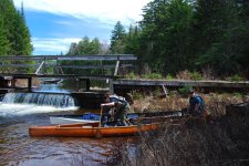
Fish barrier dam at end of St Regis

ACtC-3c0lozjVgU-MqWMmmiV71EIDPhE_SDUvBoo2-5huOxX9zkRX8Lh6g4WMueZfOrnOGqYWc2N_FtxMQVGQssMBXXk-QjjffQJUlo5A8-ew267mWhLBIWTBGQy5Ley6rrbnoH0e1ta7VZXXSamTj4Rix7FcA=w1318-h882-no?authuser=0.jpg

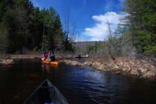
Between St Regis and Ochre

ACtC-3dAsZLTINOjp2D8b81bMnYEWbCzxTkZGnC_8KzDA8omdj3r-AKAIYZWAUoKN93CvuzZr9CPmB48nNifWDnfoHx5YWF97sbUiYPGUd_rgeAdyOa0nqDqqE-jrFTsOCuDn7m_AN2EPQGyb4Ugo4ia46-RDA=w1318-h882-no?authuser=0.jpg

We carried from Ochre to the truck trail, did not carry to Mud and beyond, it was very soggy. This was in May.

Here's a link to many more pics:
https://goo.gl/photos/JCNSWgEb6AJVaZUx8

If you go to all the pics in the link, you'll see my attempt at humor...the other guys all decided to grow their beards for this trip, but I didn't get the memo until a week or so before, and besides, my beard is all white and gray now. So, in an attempt to regain my lost youthful appearance, I used some sort of hair color stuff on a weeks worth of said facial hair, except I failed to read and follow the instructions!! Took about a half hour to scrub my skin back to normal color....Ultimately, it was a great gag, but it was funniest for reasons I had not intended!
 
Hey Stripperguy... many thanks for the pictures. I did find your trip report from several years ago. Nice trip! So, I assume that the river is not navigable below Ochre Pond? I did the carry from Fish to Mud to Ochre pond last November, so that's familiar territory.
 
River from ochre to fish??? Never heard of anyone doing that but looking at topo maps and sat photos some could be ok
Carrying around the non navigable spots might be challenging, tight vegetation and soggy footing
 
Back
Top