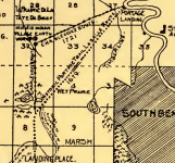
I took a side trip to the historic St. Joseph - Kankakee portage yesterday. It’s located on the northwest side of South Bend, Indiana. The portage connects the St. Lawrence and Mississippi watersheds and was used for hundreds of years by native American tribes before French explorers Lasalle, Jolliet, and Marquette were among the first Europeans to reach it.
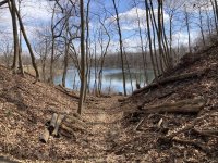
St. Joseph end of portage trail looking east
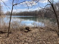
St. Joseph river portage landing
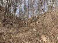
View from portage landing looking west
It was reached by paddling approx. 60 miles upriver from today’s St. Joseph, MI on the shore of Lake Michigan. The portage trail was approx. 3.5 miles long.
Today the portage is just north of Riverview Cemetery off Portage Avenue or west of Pinhook Park. The former river bend is today an oxbow called Pinhook Lagoon which is disconnected from the river by Riverside Drive.
The portage trail followed wet and dry prairie wedged in between timberland and marshes. Nowadays, the whole area is built up. In the aerial you can make out the South Bend airport. There are a few remnants of large bur oaks as you try to follow the old portage as much as possible. Where it veers from SW to S, it seemed to follow today’s Mayflower Avenue. At it’s southern end, the terrain opens up to the wide Kankakee valley. South of the railroad a ditch channels the Kankakee’s water.
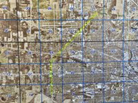
Modern day aerial view
Link to George Baker's 1899 book (free pdf download):
George Baker's: St. Joseph-Kankakee Portage (1899)
Link to PBS documentary about the Kankakee River marsh:

 www.pbs.org

St. Joseph end of portage trail looking east

St. Joseph river portage landing

View from portage landing looking west
It was reached by paddling approx. 60 miles upriver from today’s St. Joseph, MI on the shore of Lake Michigan. The portage trail was approx. 3.5 miles long.
Today the portage is just north of Riverview Cemetery off Portage Avenue or west of Pinhook Park. The former river bend is today an oxbow called Pinhook Lagoon which is disconnected from the river by Riverside Drive.
The portage trail followed wet and dry prairie wedged in between timberland and marshes. Nowadays, the whole area is built up. In the aerial you can make out the South Bend airport. There are a few remnants of large bur oaks as you try to follow the old portage as much as possible. Where it veers from SW to S, it seemed to follow today’s Mayflower Avenue. At it’s southern end, the terrain opens up to the wide Kankakee valley. South of the railroad a ditch channels the Kankakee’s water.

Modern day aerial view
Link to George Baker's 1899 book (free pdf download):
George Baker's: St. Joseph-Kankakee Portage (1899)
Link to PBS documentary about the Kankakee River marsh:

Everglades of the North: The Story of the Grand Kankakee Marsh | The Story of the Grand Kankakee Marsh
EVERGLADES OF THE NORTH explores the controversial saga of the Grand Kankakee Marsh.
Last edited:

