• Happy National Audubon Day! 🐣🐦🦅🕊️

South Saskatchewan River in Alberta

Joined
Aug 21, 2018
Messages
1,681
Reaction score
1,782
Location
Preeceville, Saskatchewan Canada
Kathleen and I have returned from the Yukon River, but it will take me a while to prepare a good trip report. In 1996 we paddled the South Saskatchewan River in Alberta, and presented it as a slide show to our canoe club in Vancouver. It was sort of a satire on our more dramatic canoe trips on the South Nahanni, the Thelon and the Coppermine Rivers. Over the last several decades we have given presentations on our various trips multiple times each. But we have presented the South Saskatchewan River only once. I would like to share that slide show here. Viewing it again, it does have some appealing attributes.

I am a bit concerned about posting images from google.photos. I posted one a few days ago in the topic "What paddles are you guys using." After a few days, the image disappeared. It's just a box with a question mark in the centre. Don't know why.

Anyway, it turns out that the South Saskatchewan has some similarities with the Yukon. Easy paddling. Virtually all Class I, with opportunities to stop in towns with campsites and burgers.

I am just finishing supper. Will try to post some images later tonight, to see if they work! If any of you have suggestions about why my last image disappeared, I would be grateful to hear them.
 
Looking forward to your report, always very interesting. I use google photos and have not had a problem so no advice here. As they say in Canada, sorry.:)
 
ssask001.jpg - Click image for larger version  Name:	ssask001.jpg Views:	0 Size:	425.5 KB ID:	100214
It is winter at our home in North Vancouver, British Columbia. Kathleen and I are both thinking next summer’s vacation. I am dreaming of wilderness canoeing.


ssask002.jpgBut Kathleen is dreaming of her Mother’s family reunion in Kinistino, Saskatchewan, visiting the house in which she was born, the scene of her favorite childhood vacations.

But I don’t want to go to a family reunion. I don't want to go to Saskatchewan. I want to go wilderness canoeing.


ssask003.jpg
But then Kathleen seduced me. As I brought her wine for her bath, she asked me to come near to whisper in my ear. What if we canoed to Saskatchewan?

"Wow. I love it when you talk like that!"


ssask004.jpg
The reunion is right on the Saskatchewan River. But going all the way would take over a month. We didn’t have that much time. So we decided to paddle part way, from the confluence of the Old Man and the Bow Rivers, which forms the beginning of the South Saskatchewan at Grassy Lake, Alberta. Then down river through Medicine Hat, past Sandy Point, and through the Suffield Military Reserve to meet the Red Deer River just upstream of our take-out at the Estuary Ferry in Saskatchewan, about 320 km (200 miles).


ssask005.jpg
Kathleen's sister Marilyn lived in Pincher Creek, Alberta - she agreed to come with us to the put in and drive our car to pick us up - on her way to the reunion.


ssask006.jpg
We left Pincher Creek in the early morning and after a stop in the mall at Lethbridge to pick up a couple of last items we found ourselves at the turnoff at Grassy Lakes from Highway 3 that led to "The Forks."


ssask007.jpg
It was a beautiful sunny day as we drove the 11 km (6.5 miles) on the gravel road - past grasslands and oil pumps.


ssask008.jpg
Suddenly we saw the “Grand Forks” of the Bow and Old Man Rivers.


ssask009.jpg
You can drive almost to the water's edge, so getting the canoe and gear unloaded and onto the beach was easy.
 

Attachments

  • ssask004.jpg
    ssask004.jpg
    533.3 KB · Views: 0
  • ssask004.jpg
    ssask004.jpg
    533.3 KB · Views: 0
Last edited:
Thanks for your kind words, Boreal Birch.


ssask010.jpg - Click image for larger version  Name:	ssask010.jpg Views:	0 Size:	566.1 KB ID:	100267
We appreciated Kathleen's sister Marilyn (behind Kathleen) providing the shuttle .But even if you don’t have a sister in Pincher Creek, the logistics of the trip are relatively convenient, as you can easily drive to the river at both the put-in and the take-out.


ssask011.jpg - Click image for larger version  Name:	ssask011.jpg Views:	0 Size:	582.9 KB ID:	100269
It’s always an exciting moment when everything is on the beach, and you are ready to embark on another canoe trip. We still have that tripod. We still have the kitchen bucket and the food bucket. We still have those same PFDs. Probably time to get new ones. We no longer have three Duluth-style canvass packs. One wore out and has been replaced by a Blue Barrel. That green Mad River Explorer is now a planter box.


ssask012.jpg - Click image for larger version  Name:	ssask012.jpg Views:	0 Size:	505.4 KB ID:	100270
We packed like any extended trip ,complete with spray cover. We didn't need a spray cover for big water, but it is good to cover gear and people, and keeps you warmer in the wind and rain.


ssask013.jpg - Click image for larger version  Name:	ssask013.jpg Views:	0 Size:	527.4 KB ID:	100271
The Grand Forks provided a major land mark for First Nations people, and for the first Europeans. Journals of the Northwest Mounted Police in 1874 reported “a considerable stream - and very swift.” They also saw “thousands of buffalo swimming across the Bow River.” Only five years later the Blackfoot recorded a winter “when first no more buffalo (came).”

Kathleen and I were wearing neoprene socks inside oversized, inexpensive tennis shoes. We now wear neoprene socks with sandals.


ssask014.jpg - Click image for larger version  Name:	ssask014.jpg Views:	0 Size:	455.0 KB ID:	100272
After 1.5 hours paddling with a gentle current we had traveled 13 km (8 miles). We found a camp spot on a sandy beach, on an island in the river.


ssask015.jpg - Click image for larger version  Name:	ssask015.jpg Views:	0 Size:	574.8 KB ID:	100273
It seemed like we were all alone in the wilderness. Except, if you look closely, you can see cows grazing on the opposite shore.


ssask016.jpg - Click image for larger version  Name:	ssask016.jpg Views:	0 Size:	610.0 KB ID:	100274
These grasslands are ranching country, much of it settled originally in the early 1900s. Although most of the land is held in grazing leases, the river is a navigable waterway, owned by the Provincial Government. The river, including its islands and sandbars, can be traveled freely.


ssask017.jpg - Click image for larger version  Name:	ssask017.jpg Views:	0 Size:	310.9 KB ID:	100275
The next day, we spent a leisurely morning photo graphing plants. This prairie sunflower (Helianthus annus?) is so representative of the Canadian Prairies.


ssask018.jpg
It seemed that whenever we became hungry, we found ourselves right at a beautiful spot for lunch.


ssask019.jpg
In this pleasant warm weather, it was nice to sit beneath the shade of the large cottonwood trees, studying our 1:50,000 topographic maps while we enjoyed lunch.


ssask020.jpg
There were many islands, overgrown with willows and cottonwoods. These picturesque cottonwood trees release their cottony seeds to coincide with the normal high water of spring run-off. Subsiding flood waters leave newly-exposed moist silt, ideal for seed germination and growth.


ssask021.jpg
The pronghorn is one of the world’s fastest animals, able to reach speeds of 95 km (60 miles) per hour.


ssask022.jpg
For lunch, we packed graham crackers (because they don’t crumble), peanut butter, cheese, beef jerky and dried fruits.


ssask023.jpg
These highly-eroded “badlands” were created by the weathering of sedimentary rocks laid down in shallow seas, estuaries and deltas of the Cretaceous Period 140 to 65 million years ago. Or so I read.


ssask024.jpg
At the end of the last ice age (or was it just the most recent glacial advance?), about 10,000 years ago, the river began to cut its present valley. Or so I read.


ssask025.jpg
Two main types of cactus occurred along the river: the pin cushion cactus, and this prickly pear. You gotta be careful where you sit down!


ssask026.jpg
Saskatchewan is derived from the Cree words “Kisiskatchewani sipi,” which mean “swiftly flowing river.” Reminders of the Cree and Blackfoot culture occur above the river, including three, large medicine wheels dating back to 1430 AD. Medicine wheels have (1) a central stone cairn, (2) one or more concentric stone circles, and/or (3) two or more stone lines radiating outward from a central point. Using this definition, there are a total of 46 medicine wheels in Alberta. They were used for a variety of likely religious or ceremonial purposes. Or so I read. I don't actually know all these details myself.
 
Last edited:
That is some stunning landscapes you ran through! Thank You for posting this! I always enjoy your stories and pictures. For some reason cactus in Canada doesn't sound right but hey, what the heck do I know! Looking forward to the next chapter!
 
Too hot outside to work, so here comes another instalment.


ssask027.jpg
It took a bit of work to find campsites each night, because the islands were so dense and overgrown.


ssask028.jpg
It was also somewhat difficult to find ideal, pristine camp sites along the banks of the river. We definitely preferred to camp primarily on islands - to avoid cows, and to avoid camping on potentially private land.


ssask029.jpg
But the extended search was always worth it when we could sit and enjoy the evening light sparkling on the water.


ssask030.jpg
We are now leaving our camp on Galt Island, just west and upstream from the town of Redcliff. The few farm houses, however, provide only a hint of civilization, which is mostly out of sight, above the river.


ssask031.jpg
After four days and 98 km (60 miles) on the river, we now anticipate arriving at the big city of Medicine Hat.


ssask032.jpg
The Trans Canada Highway, and the first of 4 bridges in Medicine Hat. The largest colony of cliff swallows along the river nest in their mud homes built beneath this busy highway bridge. It is certainly possible to stop in Medicine Hat for more supplies.


ssask033.jpg
We encountered our first people of the journey. They asked us how far we will be traveling. When we replied “To Estuary, Saskatchewan,” they called out a warning: “Look out for Rapid Narrows!”


ssask034.jpg
Near here a battle occurred between the Cree and Blackfoot. A Cree Medicine Man lost his head dress while swimming the river. The Blackfoot named the site “Head Dress of a Medicine Man.” And that is how Medicine Hat got its name. Or so I read.


ssask035.jpg
One of the greatest dangers of this section of the trip were the large waves created by the rescue boat practicing its maneuvers on the river.


ssask036.jpg
For kids on this river trip, a big attraction at Medicine Hat is the playground at Lions park, a short walk from the river.


ssask037.jpg
I could hardly keep up with Kathleen.


ssask038.jpg
Now this is wilderness tripping at its best!


ssask039.jpgI am now paddling the canoe to the picnic site at Strathcona Park , which is just downstream, a short walk from the Lions Park. It looks like I am paddling solo from the stern: lowangle al would be proud.


ssask040.jpg
Lunch at a picnic table, our first table in four days. Somewhat surprisingly, there were no organized camp grounds along the river in Medicine Hat.


ssask041.jpg
View across from the picnic site to Police Point Park, where there are nature trails and an interpretive centre.


ssask042.jpg
We are now leaving Medicine Hat, and are heading toward the outside bend, where hundreds, if not thousands of rock doves (pigeons) have left their domestic urban existence to live wild and free in the caves of the silt cliffs above the river. What more adventures wait for us on the South Saskatchewan River?
 

Attachments

  • ssask034.jpg
    ssask034.jpg
    522.7 KB · Views: 0
Last edited:
I'm really enjoying the scenery, especially from the water. Big wide open sky filling that world. Your riverside stops remind me of a Farley Mowat autobiography called Born Naked, in which he talks about the time he spent living on the banks of the South Saskatchewan during the summer months when he was young. You and Katherine could've time travelled flowing east, drifting in the whenever through rural scenes, back into the here and now through the cities. I hope you were a good partner and pushed her on the swings.
 
Thanks, Odyssey. I think the scenery gets even better, later in the trip. And there is still another playground in Kathleen’s future. I didn’t push her on the swing. I was the photographer! Will try to post more later today, but might not have time.

I didn’t know about that Farley Mowat book. Will have to check it out.
 
Keep writing Michael, you tend to weave a wonderful story! The pictures are not anything I think of Canada being like but it is a big country! I read a lot of Farley Mowat books in my teens. A great read at that time and age. I will have to catch up next week sometime. Off for some R&R in the morning. Thanks for keeping us all with reading and viewing material!

Doug
 
Another good story Michael and good photos too. I'm honored to be mentioned in that photo caption and thanks for helping to promote paddling from the stern. It's been a slow moving revolution so far.
 
ssask043.jpg
There were quite a few irrigation pumps along this section of the river. They were extremely noisy, and were the least satisfactory part of our Saskatchewan River trip.


ssask044.jpg
American White Pelicans were also very common. Much more enjoyable than the irrigation pumps.


ssask045.jpg
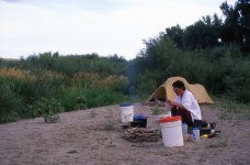
Even though we planned only 11 days for this trip, we still dehydrated all of our suppers, just like our three previous and longer wilderness canoe trips on the South Nahanni, the Thelon and the Coppermine Rivers.


ssask046.jpg
The islands were often overgrown with sandbar willows, but we could usually find suitable camps in the sandy beds of channels created during spring floods.


ssask047.jpg
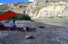
This channel, bare of vegetation, gave us an unobstructed view of the evening glow of the sun on the rim-rock canyon walls.


ssask048.jpg
The cottonwood groves came alive with the flight and song of birds every morning.


ssask049.jpg
We didn't have a telephoto lens on this trip. You have to believe me that Western and Eastern Kingbirds were quite common in the cottonwood groves.


ssask050.jpg
This leisurely trip gave us plenty of time for enjoying plants. Sneezeweed (Helenium autumnale) so named because at one time it was commonly dried and used for snuff. Its scientific name is Helenium, because the flower matched the beauty of Helen of Troy. Or so I read.


ssask051.jpg
Tick Seed (Coreopsis tinctoria) is common on sandy sites throughout the Canadian Prairies.


ssask052.jpg
Shells of a fresh water clam, called “Fat Mucket” covered the beaches, making it seem like a day at the ocean. Again, like with the Kingbird, you just have to believe me that there were lots of shells on the beaches. Our photography has gotten a little better over the years.


ssask053.jpg
After lunch, a short hike to stretch our legs, and to contemplate the lives of those who came before us on the South Saskatchewan River.


ssask054.jpg
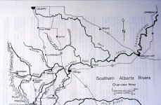
You might remember the map of 'Southern Alberta Rivers' in the beginning of this story. Well that came from the book 'Canoeing Chinook Country Rivers,' by Buhrmann and Young (1982). Their description of the South Saskatchewan River indicates that the first of two "fairly fast chutes" occurs near Mile 90 (km 144). If you look closely, you can see we are approaching this Class I rapid. You might have to squint to actually see it.


ssask055.jpg
By golly, there it is! We are now in the middle of this rapid, as Kathleen braces for the haystacks at the end of this easy stretch of Class I water. The South Saskatchewan River remains a suitable trip for families and beginning canoeists.


ssask056.jpg
We paddled by family enjoying the South Saskatchewan River on a sunny Sunday afternoon. They ask edus how far we will be travelilng. When we replied “to Estuary, Saskatchewan,” they called out a warning: “Look out for Rapid Narrows!”


ssask057.jpg
We reached the Suffield military reserve at km 156 (mile 96). The sign, barely visible behind the willows, reads: “Danger! West bank of River for next 52 miles (84 km) is a military training area. Unauthorized entry prohibited!”


ssask058.jpg
More American White Pelicans, the bird we saw most commonly along the river. It was hard to believe that they had nearly disappeared from the river valley only 30 years ago, but have now recovered because of protective measures.


ssask059.jpg
Putting up the tarp for shade I couldn’t find enough big rocks to anchor all of the guy ropes.


ssask060.jpg
But walking down the river, I did find an old tire submerged in the sand. Usually I am disappointed to find old tires, but not this time. Even with the shade from the tarp it was HOT–HOT– HOT. If only I had a beer.


ssask061.jpg
And then, floating down the river, I saw a single, unopened can of beer. The beer tasted great! I'm not making this up. It really happened.

A party of two or more canoes could easily bring a cooler for cold soft drinks and other refreshments.

I was on a roll. I hoped for a tire, and found one. I hoped for a beer, and the South Saskatchewan River delivered one. I don't know if you remember that commercial from the early 1990s for Old Milwaukee beer that featured the Swedish Bikini team? "Say, Kathleen, wouldn't it be great if the Swedish Bikini Team came rafting down the river with a cooler of Old Milwaukee Beer?"

I didn't happen. Just as well, I suppose. The ads were considered sexist, and ran for only a short time.


ssask062.jpg
But I did enjoy sitting on the beach, sipping my beer, and sharing the afternoon with a family of Willets.

--------------------------------------------------------------------------------------------------------------------------------------
That's it for now. Got to do some yard work. Can't get that commercial out of my mind, though.
--------------------------------------------------------------------------------------------------------------------------------------
 

Attachments

  • ssask045.jpg
    ssask045.jpg
    366.7 KB · Views: 0
  • ssask060.jpg
    ssask060.jpg
    646.5 KB · Views: 0
  • ssask060.jpg
    ssask060.jpg
    646.5 KB · Views: 0
Last edited:
I had a similar experience on an isolated lake in my next of the woods. We were on about day seven, the booze was gone, it was hot as heck. We saw a rockie little point to stop for a rest, and I mentioned how good a beer would be. I looked down, and there was an unopened bottle of Schooner beer, a beer only available in Nova Scotia at the time, and one of my old favorites. How it had ended up in Northern Ontario at just that moment still mystifies me.
 
ssask064.jpg
Unlike our trips in the far north, there were no bugs and the morning was pleasantly warm.


ssask065.jpg
Approaching the second Class I rapid mentioned in the book by Buhrmann & Young at km 166 (mile 104).


ssask066.jpg
Hearts beat faster as we see the white line of the rapid.


ssask067.jpg
Kathleen prepares to brace and power through the haystacks.


ssask068.jpg
Nearly through the 2nd rapid. Only two remaining for the rest of the trip.


ssask069.jpg
After a brief double-take, thinking of rattle snakes, which are common in the area, we find instead only a dead bull snake floating down the river.


ssask070.jpg
We are now approaching the only rapid marked on the topographic maps at km 195 (mile 121).


ssask071.jpg
We are now leaving the only rapid marked on the map, which was really nothing at all. Once agin, this illustrates that paddlers should always independently assess the river. Don’t rely only on the map, as sometimes rapids can exist where nothing is marked, and sometimes marked rapids are nothing at all.


ssask072.jpg
We’re now camped not on an island, but on the river bank, where it is often very hard to find camp sites without pumps or cows. We have found a site without the sound of pumps, but we must share it with the cows.


ssask073.jpg
Even harder to camping in the military reserve, which borders both sides of the river for approximately 21 km (13 miles) - but, like everywhere else along the river, you can legally camp below the normal high water line. I found those pants in a fanny pack on a portage trail on the Thelon River in 1993. Wore them for almost 25 years. A very good find!


ssask074.jpg
Prairie cone-flower (Ratibida columnifera). These wildflowers have the colour and vibrancy of the sun, which shone throughout the trip. On prairie rivers, it's essential that you take a hat and lots of sun screen.


ssask075.jpg
After a leisurely breakfast and morning, we loaded the canoe and floated lazily past the sculptured landscape that bordered both sides of the river.


ssask076.jpg
We are now only 1 km (0.5 miles) upstream from Rapid Narrows. Everyone we talked to along the river and after the trip were concerned about our safety in Rapid Narrows. We wondered just how bad these “Rapid Narrows” would be!


ssask077.jpg
Would Rapid Narrows be like the drop on the Cowichan River on Vancouver Island in 1992, where the boy scouts open the bank kept calling out to us, "Canoeists. Waterfall. Canoeists. Waterfall! " We knew about the waterfall, as we had paddled the Cowichan several times before. Kathleen had gotten out of the boat, preferring not to plunge bow first over the precipice. Note, lowangle al, that I am paddling in the stern in a tandem canoe. Of course, I had no choice. Air bags prevented me from paddling backwards from the bow.


ssask078.jpg
The topographic map showed a sharp bend to the north.


ssask079.jpg
Although no rapid symbols were indicated, the map clearly identified “Rapid Narrows!”


ssask080.jpg
Would Rapid Narrows be anything like the rapids we had previously encountered on the Thelon River, in 1993, which were also often unmarked and usually un-named?


ssask081.jpg
Entering Rapid Narrows.


ssask082.jpg
Leaving rapid narrows, where the book by Buhrmann & Young indicates that 1 metre (3-4 foot) waves often occur on the outside bend at high water. The book also reports large hydraulics on the inside bend. There was no rapid however, and everyone’s concern for our safety was unnecessary. Perhaps at higher water levels Rapid Narrows would be more impressive, but we were somewhat disappointed.

-------------------------------------
Getting late. Off to bed.
------------------------------------
 
Last edited:
This is great !!!

Two questions !

Any motor boat traffic, other than the rescue boat ?

And where there any Prairie dogs ?

Thanks ! I needed this !

Jim
 
Jim,

That rescue boat was the only other boat on the river that we saw for the entire trip. And no, sorry to say, we did not see any prairie dogs. Glad to hear that you are enjoying our trip. It makes the postings feel very rewarding.
 
Thanks !

One more question !
Did you filter water, or take water with you ?

Again enjoying this trip !

Jim
 
Interesting you should ask, Jim. That discussion is coming up in the third slide in my next posting. It would be challenging to take enough water for 11 days. Because we knew there would be cows, we took along an MSR MiniWorks filter. We had not filtered on any of our three previous wilderness trips.

We have a routine medical appointment today, and have to go to a larger community (Yorkton) about one hour away. Will do some shopping. Tonight I have to try to fix the washing machine. It makes a horrible noise during the spin cycle. There was only one appliance repair guy here in Preeceville, and he recently retired. I don't really know what I'm doing, but have enjoyed watching some Youtube videos. We'll see how it goes.
 
Back
Top