• Happy Weed Appreciation Day! 🌱🌿🌻

Printing maps?

Joined
Oct 29, 2020
Messages
103
Reaction score
58
Location
Duluth, MN
I'm in the beginning stages of planning a trip on the Albany river and as I look at the cost of buying the necessary maps, I'm trying to figure out if there's a cheaper approach than ordering $400+ worth of 1:50,000 maps? Any suggestions/ideas would be appreciated.

-tomo
 
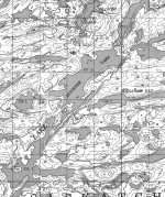
All the Canadian topos are available for free download on line. Once downloaded, you could pay someone with a large format printer to print them for you (expensive) or just snip the sections you need off your screen and print them on ordinary 8.5 x 11 paper - only cost is the paper and toner, I'm cheap so I print on both sides. A sample image is attached. One thing I like to do is change the "scale" of the images I snip out - by changing the size on screen - so I can zoom in on complex sections and zoom out on long lake sections.

-wjmcFall C.PNG
 
Particularly on long trips, I paddle and navigate primarily with 1:250,000 maps. I use 1:50,000 maps only for sections of the river that might be problematic, such as indistinct routes or a series of closely-spaced difficult rapids.
 
My eyes have gotten bad over the years, so I now find 1:250,000 maps difficult to read. I'll look into downloading and printing. Thanks!
 
As above. If you use something like CalTopo you can just print the parts of the map sheet around the river. You can create a multi page PDF with overlapping pages to cover your route. Page size depends upon your subscription level and what size printer you have.
 
You might want to consider printing on Rite-In-The-Rain printer paper or hot-laminating the maps. Not cheap ($90 for a ream of paper) but worth it for peace of mind and longevity. You can annotate the Rite-In-The-Rain paper with a pencil, the laminated maps not so much.
 
Pretty much echoing the above comments. I use Alltrails Pro to create and print maps on waterproof paper, since they are my maps they can be made to any scale and I can overlay routes on them, calculate distances, etc. There are alternatives to Rite-In-The-Rain waterproof paper, some cheaper, some not...shop around.
 
I print my own 8 1/2 x 11 maps at home of whichever scale I need. Hang them on a clothesline and spray them with a water sealant. They go in ziplock bags for the trip.
 
Odyssey said:
I print my own 8 1/2 x 11 maps at home of whichever scale I need. Hang them on a clothesline and spray them with a water sealant. They go in ziplock bags for the trip.
Do you print them in the original colours, or do you print them in black and white? I do mine in b&w as my printer is not of great quality and cannot distinguish the subtitle differences of the maps colouring.

G.
 
When I paddled the Yukon River, I did not need detailed topographiic information, only the most recently available river channel iand island location information. So I downloaded imagery from Google Earth which had 2-3 year old map images, since the river channels change almost annually. I cropped the images to approximate ten mile segments and printed on regular computer paper. It took 95 sheets to cover the 1000 mile race route. You can choose to overlay coordinate information lines on the maps as well, which I did not necessarily need on all of them.
I then layed out the 95 pages on my garage floor and spray coated both sides with a fairly cheap waterproof spray from Walmart. I then put each page in a protective plastic sleeve and collected then all in a 3-ring binder. They have survived more than one trip down the Yukon River, even after getting wet in the bottom of my canoe.

In the past I have used Thomson's Water Seal as well with great success on topo maps. Not only does it waterproof, iit also makess the paper somewhat resistant to tearing. Just be sure to use the more liquid variety of TWS, not the gel, as that will darken white paper.
 
Last edited:
Many Canadian maps are still only in black and white so colour isn’t an issue. Both CalTopo and Gaia GPS have an alternative satellite image database than Google Earth, Mapbox I think. It often seems to have much higher resolution imagery for northern Canada.
 
Paper maps are wonderful and comforting. They are fixed at whatever scale they are printed. Why not bring an electronic device, run something like Gaia, and have (downloaded) maps you can zoom to whatever scale you need? An additional benefit is the blue dot showing where you are on the map. in airplane mode, the battery will last weeks and there are LI power packs and solar chargers if you need to recharge. If the device isn’t waterproof, there’s a waterproof case. I love a paper map, but electronics are easier and more useful, and have additional functions. Try taking a photo with your paper map.
 
Because some of us prefer the traditional methods. I can put my compass on the map and measure an azimuth and direction the way I learned years ago. I can hold the map up and rotate it to match the landscape I see, just like navigators have done for eons. And it is not just comfortring, iit always works.
 
I've used and been happy with mytopo.com maps.
You can choose whatever scaling you like, the physical size of the map, orientation (horizontal or vertical) and regular paper or waterproof. But the best part is you can select the area you want the map to cover so you're not stuck buying an entire map just because you need a sliver of one edge. For long routes it's a great way to get by with a minimum of maps.

Personally I have no desire to print my own maps on small pieces of paper and don't know anyone with a large format printer (or waterproof paper).

Like paddlinpit said I've also used 1:250,000 maps for very large lakes or other areas where I don't need the detail and 1:50,000 maps elsewhere. Sometimes even 1:25,000 if I think I'll need it.

Alan
 
Odyssey said:

Do you print them in the original colours, or do you print them in black and white? I do mine in b&w as my printer is not of great quality and cannot distinguish the subtitle differences of the maps colouring.

G.
I print the scanned topo green layer version with the contour lines. I add campsites, pictograph sites, portages, and magnetic north lines at strategic locations for compass use.
Our printer is an inkjet. Terrible. The waterproofing is necessary. So too is the clear Ziplock.
 
Last edited:
On all of my trips, it has been guaranteed that I will need a map that contains a very small corner of the route between two adjoining maps. I contemplate not getting it, but I can’t help myself. I love maps.

A major feature for me of having a large map compared to a narrower, cropped map, is that I can place myself in the broader landscape. Toward this end, I usually also buy 1:1,000,000 topo maps. In the tent at night I revel in studying the macro-scale of the landscape in which I currently live. All those distant place names cause me to wonder and speculate.
 
On all of my trips, it has been guaranteed that I will need a map that contains a very small corner of the route between two adjoining maps. I contemplate not getting it, but I can’t help myself. I love maps.
Chances are I will at some point be on some future trip that takes me on the broader area beyond each of the four cornerss of the maps that I need anyway. So I will get them all. So, having a huge selection of area maps (I have a stockpile of more than 300 topo maps) has over the years proven very helpful for odd SAR incidents on maps that I might not normally plan to take my own recreational trips on. Having a paper map spread out in front of me before my trip allows me to do some serious large and small scale detailed map study of my upcoming trip. One of my pet peeves for pre-trip land navigation study for expedition trips that few people seem to do. I navigate old-school map and compass methods for the fun of it. Using newer technology does not do it for me. During a SAR incident, or when canoe racing , of course I do use GPS and more advanced technology techniques, but not when I am simply recreating for pleasure on my own in the backcountry.
 
Thanks, all. I will examine the various options referenced above. I, too, love maps, and now that I reflect on it I'm sure there are some sections (lower Albany in particular--prior to the delta) where 1:250,000 maps would suffice. Poor eyesight aside, I often prefer the large scale as I'm not so obsessed with ticking off every reference point 1:50,000 maps provide, if that makes sense.
 
Back
Top