- Joined
- Jul 6, 2021
- Messages
- 643
- Reaction score
- 1,184
AKA OOSOBO gets wet.
I took OOSOBO, the four-times rebuilt MRC Explorer, out on the reservoir for an inaugural paddle. Simply packing for the trip felt odd; I kept suddenly thinking “Oh crap, I still need to put the canoe on the roof racks”.
No, the canoe is already at the reservoir. You just need paddles and PFD, and the padlock key. I still couldn’t shake the feeling something was missing. With the exception of a sea kayak trip 20 years ago I have never not put a canoe on the roof racks when going paddling, usually at least two and sometimes four. It continued to feel too easy, I-forgot-something, weird.
The reservoir parking lot was deserted, not a soul in sight.
 P3090002 by Mike McCrea, on Flickr
And every single space to leave a boat chained up was filled. And then some, the last few unfortunates at (beyond) the end of the stout cable had chained their boats to a flimsy fence that could be cut with a pair of nip snips.
 P3090001 by Mike McCrea, on Flickr
Best of luck with that folks. I had an old aluminum beater stolen before I ever had a chance to paddle it there 30 years ago, secured to the perimeter cable with a huge padlock and thick chain. It vanished a week after I chained it up; boat, lock, chain and all. I still wonder how they accomplished that, and why. There were much nicer boats there, some secured with decorative plant hanger chain and wimpy combination locks.
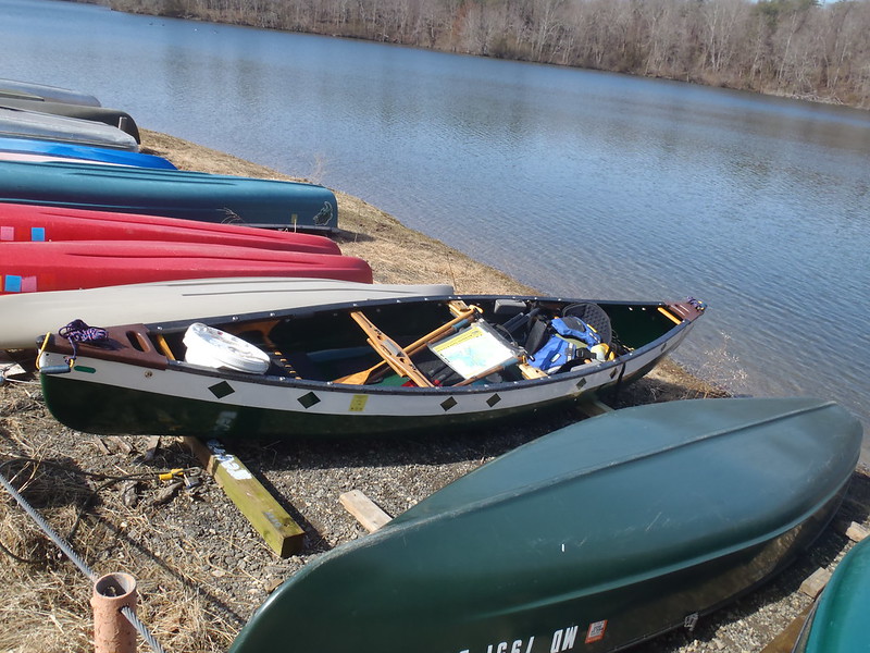
Once at the reservoir I experienced the easiest canoe launch ever. With OOSOBO unlocked, rolled upright and gear loaded I grabbed a painter, gave the canoe a gentle nudge and it slid gracefully down the 4x4’s and into the lake, fully afloat. Of course the reservoir is currently brimful; if we have a drought year there may be a short drag to water’s edge. Yes, slid and maybe future dragged – 88lb canoe.
 P3090003 by Mike McCrea, on Flickr
With the reservoir levels high I had decided to head for the bottom of Hemlock Gorge, perhaps the prettiest and most unique place in the county.
http://www.midatlantichikes.com/id75.html
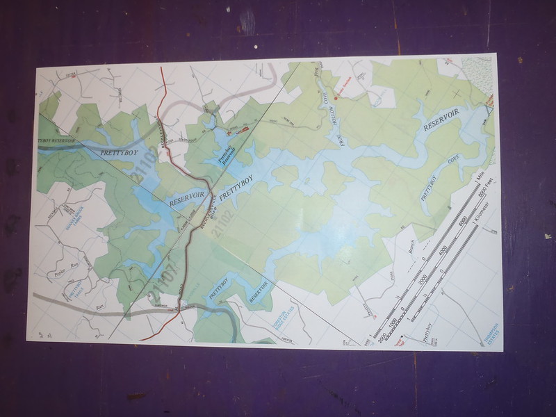
With the advent of GPS and Smartphones there are no decent maps of the reservoir. So I made one, four pages an old large scale (2 ½ inches = 1 mile) color county map book cut and joined together. Actually I needed two copies of that mapbook, the reservoir area was on back-to-back pages 1 & 2 and 5 & 6. Luckily I had multiple copies of that map book from my work days.
I wanted to get as much of the reservoir one photocopy-able page as possible, from the dam at the south end to the Gunpowder Falls inlet stream in the north.
 P3100011 by Mike McCrea, on Flickr
Color photocopied to fit on a single piece of 8 ½ x 14 paper, which goes nicely in my map case, and in XL Zip-locks along with the (correct) padlock key for Brian’s offspring’s to use.
 P3110017 by Mike McCrea, on Flickr
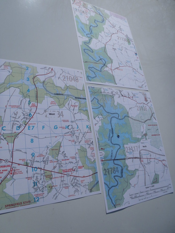
I liked the scale and detail of that DIY map so much I made one for Liberty Reservoir as well. Liberty is a long, linear North/South lake, with one long western arm, so actually three sectional maps 8 ½ x 11 maps to complete easily photocopied coverage of the entire reservoir from inlet to dam.
 P3100015 by Mike McCrea, on Flickr
Copies of those maps have already been distributed to a few reservoir paddling friends, and I’m sure I will give more of them away.
Off I went with no canoe on the roof racks. It had been at least 10 years since I last paddled on Prettyboy. It had been more than 20 years since I last solo paddled bow backwards. The Explorer, in any guise, is not a fast canoe, nor especially glideful.
Mistakes were made; I brought a 5 gallon bucket with lid to fill with lake water and use as bow ballast for trim. Eh, I should have brought two of those, OOSOBO was still a bit too bow light.
And I had forgotten how long a (yes) double blade I prefer when bow backwards, initiating a low-angle stroke forward at the widest center part of the hull. I brought my favorite 260cm carbon Camano. Next time I’ll bring the 270cm carbon Breeze. Or channel my inner Memaquay and bring a 230cm kayak paddle and a can of spam for frustration salvation.
Out around the corner, leaving the still empty parking lot behind.
 P3090005 by Mike McCrea, on Flickr
North towards Hemlock Gorge. Once past the nearby Beckleysville Rd Bridge I do not expect to see anything or anyone. Maybe a hiker on one of the trails. I had laid out a fine necklace chain on the mapped paddling route, it should be about 3 ½ miles to the bottom of Hemlock Gorge, which is just off my map a bit further north.
 P3090006 by Mike McCrea, on Flickr
No hikers. Not many other life forms, a few geese and wood ducks, one lonely great blue. No mammals, and not much in the way of Passeriformes twitterers. There is more wildlife in my backyard. Although the fringe of the reservoir was mostly left in natural hardwoods much of the watershed was planted in monoculture straight row Virginia Pine in the CCC days, and is essentially a dead zone.
I’ll try to time a spring reservoir paddle for one of the Warbler migrations, but I do not have high hopes. To paraphrase WC Fields, “I’d rather be on some eastern shore or Carolina’s blackwater river for warbler migration”. Or anywhere but Philadelpia. Like WC I too once spent a week there, I think it was a Sunday.
Seriously, timing trips for peak migration on the Atlantic flyway can be awesome. Even for Snow Geese.
https://www.bayjournal.com/travel/s...over,between Massachusetts and South Carolina.
If a flock passes overhead I recommend not gaping skyward slack jawed. Or at least keep your mouth closed. PATOOIE!
It proved to be a bluebird morning on the reservoir, with naught but a light breeze. Which was good, because OOSOBO was riding bow high. Up in the narrower more riverine end of the reservoir the shoreline begins to show good bones, promising the gorge not far ahead.
 P3100007 by Mike McCrea, on Flickr
I had paddled off my map, and recollection said I must be getting close. WTF, there’s another road bridge. I have no memory of that obviously old bridge, which I must have paddled under before. I knew I was on the correct course, but I have been known to get lost and studied the map more closely.
Nope, I’m right where I should be, just paddled off the map. Carry on, can’t be far.
Eh, turns out the bottom of Hemlock Gorge is a couple miles past the end of my “custom” reservoir map. Whatever, it is more enjoyable paddling betwixt intimate banks than the dull open reservoir. Still no critters, which was a disappointment. Still no people, which made it worthwhile.
 P3100009 by Mike McCrea, on Flickr
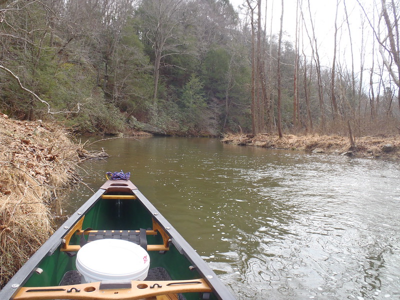
And paddle on. Thank goodness for the double blade, even if it was too short. The Gunpowder stream seemed lower and shallower than I remembered. Although by now I was beginning to question my memories.
I came to a too-shallow riffle. And could see another too-shallow riffle 100 yards ahead. I think the bottom of Hemlock Gorge is less than a half mile ahead, but much of the remaining journey would be a wade. Close enough, it was clouding over and getting breezy, time to slowly noodle back.
 P3100008 by Mike McCrea, on Flickr
I stopped on the way out for an eddy commune with SO, Subsequent Owner, my late great friend Brian. He was quiet as usual, and I did most of the talking.
 P3100010 by Mike McCrea, on Flickr
That is a piece of old Coroplast yard sign in the map case, keeping the case rigid and easily readable.
It was slow, and less of a noodle than anticipated. It breezed up a head wind or, on a serpentine course, a side wind. OOSOBO was still bow light, but now more of a sail. My paddling friends would be surprised, but I actually used a single blade, with little correction on the off-wind side en route back. As usual single blading tortured my damaged right wrist, but it was better than waggling four feet of unused paddle around on the windward side.
The launch was still deserted but for my truck, although it mysteriously appeared on the opposite side of the reservoir from where I expected on the map. A map which I had turned around on the thwart for southbound orientation. No wonder I get lost sometimes.
Also the easiest take out and pack up ever. I slid OOSOBO upright back onto the 4x4’s and emptied gear. This time, instead of leaving my truck 100 feet away in the middle of the parking lot like a dumb arse, I parked it six feet from the canoe. Not sure why I didn’t do that when I loaded the canoe instead of walking back and forth. Think man, think!
I checked the gauge for the Gunpowder stream when I got home. The upper Gunpowder doesn’t have a large drainage area, and is not a high volume stream. Typically 40 CFS at this time of year it was running closer to 20 CFS. Glad I called it quits when I did, I was out for a paddle, not a walk.
Back at home I found the map book extension page further north. The “mystery” bridge was Clipper Mill Rd, one I have driven over every time I’d hiked Hemlock gorge. And my 3 ½ mile paddle to the bottom of Hemlock Gorge was more like 6 miles up the reservoir and stream. And six miles back.
That was plenty for the day, and I definitely enjoyed some ibuprofen the next morning. And think I need to start taking one of those miracle brain supplements.
I could have paddled all the way south to the dam, or up any of the long inlet coves. Next time, and next time I swear I’m bringing fishing gear, and a longer double blade. And a second 5 gallon ballast bucket.
There was some fishy business at home before I left. We had a visitor using the turnaround spot in the driveway.
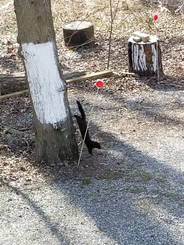 20220308_152946 by Mike McCrea, on Flickr
All in all a fine day on the reservoir.
I took OOSOBO, the four-times rebuilt MRC Explorer, out on the reservoir for an inaugural paddle. Simply packing for the trip felt odd; I kept suddenly thinking “Oh crap, I still need to put the canoe on the roof racks”.
No, the canoe is already at the reservoir. You just need paddles and PFD, and the padlock key. I still couldn’t shake the feeling something was missing. With the exception of a sea kayak trip 20 years ago I have never not put a canoe on the roof racks when going paddling, usually at least two and sometimes four. It continued to feel too easy, I-forgot-something, weird.
The reservoir parking lot was deserted, not a soul in sight.
P3090002 by Mike McCrea, on FlickrAnd every single space to leave a boat chained up was filled. And then some, the last few unfortunates at (beyond) the end of the stout cable had chained their boats to a flimsy fence that could be cut with a pair of nip snips.
P3090001 by Mike McCrea, on FlickrBest of luck with that folks. I had an old aluminum beater stolen before I ever had a chance to paddle it there 30 years ago, secured to the perimeter cable with a huge padlock and thick chain. It vanished a week after I chained it up; boat, lock, chain and all. I still wonder how they accomplished that, and why. There were much nicer boats there, some secured with decorative plant hanger chain and wimpy combination locks.
Once at the reservoir I experienced the easiest canoe launch ever. With OOSOBO unlocked, rolled upright and gear loaded I grabbed a painter, gave the canoe a gentle nudge and it slid gracefully down the 4x4’s and into the lake, fully afloat. Of course the reservoir is currently brimful; if we have a drought year there may be a short drag to water’s edge. Yes, slid and maybe future dragged – 88lb canoe.
P3090003 by Mike McCrea, on FlickrWith the reservoir levels high I had decided to head for the bottom of Hemlock Gorge, perhaps the prettiest and most unique place in the county.
http://www.midatlantichikes.com/id75.html
With the advent of GPS and Smartphones there are no decent maps of the reservoir. So I made one, four pages an old large scale (2 ½ inches = 1 mile) color county map book cut and joined together. Actually I needed two copies of that mapbook, the reservoir area was on back-to-back pages 1 & 2 and 5 & 6. Luckily I had multiple copies of that map book from my work days.
I wanted to get as much of the reservoir one photocopy-able page as possible, from the dam at the south end to the Gunpowder Falls inlet stream in the north.
P3100011 by Mike McCrea, on FlickrColor photocopied to fit on a single piece of 8 ½ x 14 paper, which goes nicely in my map case, and in XL Zip-locks along with the (correct) padlock key for Brian’s offspring’s to use.
P3110017 by Mike McCrea, on FlickrI liked the scale and detail of that DIY map so much I made one for Liberty Reservoir as well. Liberty is a long, linear North/South lake, with one long western arm, so actually three sectional maps 8 ½ x 11 maps to complete easily photocopied coverage of the entire reservoir from inlet to dam.
P3100015 by Mike McCrea, on FlickrCopies of those maps have already been distributed to a few reservoir paddling friends, and I’m sure I will give more of them away.
Off I went with no canoe on the roof racks. It had been at least 10 years since I last paddled on Prettyboy. It had been more than 20 years since I last solo paddled bow backwards. The Explorer, in any guise, is not a fast canoe, nor especially glideful.
Mistakes were made; I brought a 5 gallon bucket with lid to fill with lake water and use as bow ballast for trim. Eh, I should have brought two of those, OOSOBO was still a bit too bow light.
And I had forgotten how long a (yes) double blade I prefer when bow backwards, initiating a low-angle stroke forward at the widest center part of the hull. I brought my favorite 260cm carbon Camano. Next time I’ll bring the 270cm carbon Breeze. Or channel my inner Memaquay and bring a 230cm kayak paddle and a can of spam for frustration salvation.
Out around the corner, leaving the still empty parking lot behind.
P3090005 by Mike McCrea, on FlickrNorth towards Hemlock Gorge. Once past the nearby Beckleysville Rd Bridge I do not expect to see anything or anyone. Maybe a hiker on one of the trails. I had laid out a fine necklace chain on the mapped paddling route, it should be about 3 ½ miles to the bottom of Hemlock Gorge, which is just off my map a bit further north.
P3090006 by Mike McCrea, on FlickrNo hikers. Not many other life forms, a few geese and wood ducks, one lonely great blue. No mammals, and not much in the way of Passeriformes twitterers. There is more wildlife in my backyard. Although the fringe of the reservoir was mostly left in natural hardwoods much of the watershed was planted in monoculture straight row Virginia Pine in the CCC days, and is essentially a dead zone.
I’ll try to time a spring reservoir paddle for one of the Warbler migrations, but I do not have high hopes. To paraphrase WC Fields, “I’d rather be on some eastern shore or Carolina’s blackwater river for warbler migration”. Or anywhere but Philadelpia. Like WC I too once spent a week there, I think it was a Sunday.
Seriously, timing trips for peak migration on the Atlantic flyway can be awesome. Even for Snow Geese.
https://www.bayjournal.com/travel/s...over,between Massachusetts and South Carolina.
If a flock passes overhead I recommend not gaping skyward slack jawed. Or at least keep your mouth closed. PATOOIE!
It proved to be a bluebird morning on the reservoir, with naught but a light breeze. Which was good, because OOSOBO was riding bow high. Up in the narrower more riverine end of the reservoir the shoreline begins to show good bones, promising the gorge not far ahead.
P3100007 by Mike McCrea, on FlickrI had paddled off my map, and recollection said I must be getting close. WTF, there’s another road bridge. I have no memory of that obviously old bridge, which I must have paddled under before. I knew I was on the correct course, but I have been known to get lost and studied the map more closely.
Nope, I’m right where I should be, just paddled off the map. Carry on, can’t be far.
Eh, turns out the bottom of Hemlock Gorge is a couple miles past the end of my “custom” reservoir map. Whatever, it is more enjoyable paddling betwixt intimate banks than the dull open reservoir. Still no critters, which was a disappointment. Still no people, which made it worthwhile.
P3100009 by Mike McCrea, on FlickrAnd paddle on. Thank goodness for the double blade, even if it was too short. The Gunpowder stream seemed lower and shallower than I remembered. Although by now I was beginning to question my memories.
I came to a too-shallow riffle. And could see another too-shallow riffle 100 yards ahead. I think the bottom of Hemlock Gorge is less than a half mile ahead, but much of the remaining journey would be a wade. Close enough, it was clouding over and getting breezy, time to slowly noodle back.
P3100008 by Mike McCrea, on FlickrI stopped on the way out for an eddy commune with SO, Subsequent Owner, my late great friend Brian. He was quiet as usual, and I did most of the talking.
P3100010 by Mike McCrea, on FlickrThat is a piece of old Coroplast yard sign in the map case, keeping the case rigid and easily readable.
It was slow, and less of a noodle than anticipated. It breezed up a head wind or, on a serpentine course, a side wind. OOSOBO was still bow light, but now more of a sail. My paddling friends would be surprised, but I actually used a single blade, with little correction on the off-wind side en route back. As usual single blading tortured my damaged right wrist, but it was better than waggling four feet of unused paddle around on the windward side.
The launch was still deserted but for my truck, although it mysteriously appeared on the opposite side of the reservoir from where I expected on the map. A map which I had turned around on the thwart for southbound orientation. No wonder I get lost sometimes.
Also the easiest take out and pack up ever. I slid OOSOBO upright back onto the 4x4’s and emptied gear. This time, instead of leaving my truck 100 feet away in the middle of the parking lot like a dumb arse, I parked it six feet from the canoe. Not sure why I didn’t do that when I loaded the canoe instead of walking back and forth. Think man, think!
I checked the gauge for the Gunpowder stream when I got home. The upper Gunpowder doesn’t have a large drainage area, and is not a high volume stream. Typically 40 CFS at this time of year it was running closer to 20 CFS. Glad I called it quits when I did, I was out for a paddle, not a walk.
Back at home I found the map book extension page further north. The “mystery” bridge was Clipper Mill Rd, one I have driven over every time I’d hiked Hemlock gorge. And my 3 ½ mile paddle to the bottom of Hemlock Gorge was more like 6 miles up the reservoir and stream. And six miles back.
That was plenty for the day, and I definitely enjoyed some ibuprofen the next morning. And think I need to start taking one of those miracle brain supplements.
I could have paddled all the way south to the dam, or up any of the long inlet coves. Next time, and next time I swear I’m bringing fishing gear, and a longer double blade. And a second 5 gallon ballast bucket.
There was some fishy business at home before I left. We had a visitor using the turnaround spot in the driveway.
20220308_152946 by Mike McCrea, on FlickrAll in all a fine day on the reservoir.