Just a quick followup. In short, Algonquin was superb. What a gem. I only had four days and three nights, but I am sure I will be back for more. I rented all my gear from a well known local outfitter, and I found their service outstanding. Getting my gear to the starting point was a snap. The canoeing, the fishing, the camping and all else over the next few days was better than I had ever imagined. Wish I'd live closer.
-
Happy National Sunglasses Day! ☀️🕶️😎
You are using an out of date browser. It may not display this or other websites correctly.
You should upgrade or use an alternative browser.
You should upgrade or use an alternative browser.
Multi-Day Flat Water Options OR, WA, BC?
- Thread starter Dagger
- Start date
- Joined
- Nov 22, 2016
- Messages
- 218
- Reaction score
- 332
OK Dagger.
You can't just leave it like that.
Shall I assume you rented from AO?
Where did you go?
Access?
Lakes?
Portages?
Agreed that Algonquin is a gem- though it can be VERY busy in peak summer months. The Park varies quite a bit West to East side and North to South.
Glad you had time to enjoy your trip.
Bruce
Agreed. I apologies for the lack of detail. It was a late evening post ")
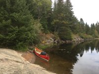
Yes. I rented my gear from Algonquin Outfitters at their Oxtounge Lake location. AO's staff was super friendly and helpful. The gear was heavy duty, with an emphasis on heavy, but that is to be expected since it is rental gear and needs to last. Subsequently, my pack was not something I would have enjoyed hauling across long portages. Since only shorties were on my itinerary, the pack weight didn't bother me. As a side note, soon or later I will buy one of AO's portage packs. They are great quality/size at half the price (or less) of some of the well known brands. I had opted for a 16' Prospector in Swift's Kevlar Fusion layup. The canoe was a dream to paddle from the bow seat forward, with my portage pack riding either in front of, or on the bow (formerly stern) seat. A solo canoe might have been more nimble and a yet lighter, but I came to appreciate the extra free board of the Prospector on my last day, where a stiff breeze whipped up sizable white caps on Rock Lake. I never felt unsafe in that Prospector.
Planned Itinerary(s):
My primary plan was to access at Rock Lake, portage into Pen Lake where I would stay the first night. On 2nd day I was going to portage into Clydegale Lake where I was going to explore and stay the 2nd night. On my 3rd day I was going to do the same route in reverse, staying a 3rd night at Rock Lake. So far for best-laid plans. When I got to the Parks Office I learned that Pen and Clydegale were already full, so a secondary plan formed. Access at Rock Lake, portage into Galeairy Lake and stay the 1st night there. On 2nd day I was going to portage to Night Lake and on to Pen Lake for the 2nd night (my hoe was that I would find a site, even though Parks said there weren't any). That alternative plan deserved a lot of additional thought, as considerations of pack weight now had to come into play. My planned short portages had morphed into some extended trail time. On the 3rd day I would do the same route in reverse.
What actually happened:
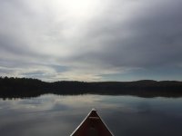
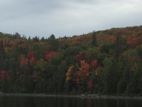
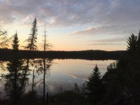
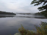
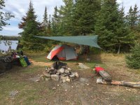
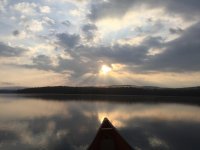
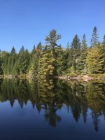
I accessed at Rock Lake and paddled south, along the east side of R. L. because I was going to save the west side, the islands and the petroglyphs for my return trip in a few days. About half way down R.L. I got turned around right after the southern most island. A pparently it is true that islands shorelines are nearly indistinguishable from surrounding shore lines. Something I had never been faced with, as the lakes I typically paddle are tiny compared to where I was now. Getting turned around like that was a sobering realization, as I previously thought my navigational skills weren't that bad. After a break I decided to follow the western shoreline instead of the east, as the west side would inevitably lead me to the short portage trail to Galeairy Lake. My next unexpected obstacle was the apparently low water level of Rock Lake, which had exposed a sizable, un-navigable field of rocks and boulders between me and the portage. Judging by the many paint marks on the rocks, others had tried to navigate around or through this mine field. I opted to get out of the canoe instead and guide, carry, all my gear. That took the better part of an hour and gifted me with a rolled ankle when my foot slipped off one of an algae covered, slimy rock. Finally at Galeairy, I took a breather, soaked my ankle in the cold water and admired the scenery. Fall colors started to come in and the water was like glass. I almost felt bad I was going to disturb this silence and serenity. As it was mid-afternoon by now, I opted to look for a camp site at Galeairy and call it a day. My map showed a camp site at an island not too far from the portage. When I got to the island I looked for the bright orange camp site sign but couldn't find it. As I circled the island, I found the camp site and decided to check it out anyway. I was thinking that perhaps I wasn't supposed to camp there because the sign was gone, but I found the site quite nice, and left over bits and pieces of civilization indicated recent use. I checked off the few signs of a good camp site AO staff had told me about (no bear turds in camp, no food in thunder box, good supply of fire wood near by) and settled in. I got a few bass right off the bank and I enjoyed a very pleasant and quiet evening without bugs or any other disturbances. The next morning, my rolled ankle was pretty unhappy with me, and the thought of portaging became less and less attractive. I decided to stay on the island and use it as home base for exploration instead. I paddled (and short portaged) into Night Lake and I explored the the east side of Galeairy Lake, which turns into a huge body of water as it gets closer to the park's edge. Till my departure, I spent my time paddling glassy coves, fishing and otherwise basking in the silence of it all. One of the more memorable events were the calls of the Loons early in the morning. I had always thought of that sound as such a cliche of the north, but here they were, and their haunting calls are really quite something. Departure day came too soon, and I was reminded by the pelting rain, of the importance of a properly rigged tarp. The contraption I had managed to create was less than adequate, given the circumstances. Still, my surroundings were beautiful even in the rain, and mild temperatures allowed me to ignore getting soaked and instead enjoy where I was. I remember looking forward to returning to my family in California, but when I was on the water and a few hundred yards away from the island, I looked back and I realized how strangely at home I felt there. I could have easily stayed a few days longer, but unfortunatly I had a plane to catch. More time next time!
The water level at Rock Lake had apparently gone down even more in the past few days (not sure where all the water went), and now there was a sizable mud patch between the portage and the water, followed by the rock field mentioned earlier. Except now it was also raining and the wind had increased to a meaningful level. It was at this time that I really appreciated the extra free board of the Prospector because I might have been wind bound in a smaller canoe. Once I made it through those obstacles, I paddled north, past the islands on my way to see the petroglyps, which I sadly never found. Yay - One more reason to come back!. My plan was to return my gear and stay the night at one of AO's tent cabins, before returning my rental car and catching my flight out of Toronto. However, once I was back in my car and with my gear all sorted out, my achy bones and my own smell caught up with me and I really really longed for a hot shower and a real bed. A few hours later I checked into a motel in Huntsville (quaint little town with good restaurants) for my final night in Canada.
Things I was glad I brought from home:
NRS Boundary Water Shoes - beats having wet feet the entire trip
Wax cotton Tilly hat - It was sunny most of the time but it rained one entire day
Pump style water filter - AO standard issue was iodine tablets which make water potable but tasting bad, and the amount of water I consumed would have been a chore to handle with tablets and the 1 quart drinking bottle I had.
Good solar phone charger - No cell service (thank goodness) but I took photos and video with my phone
DanForce Headlamp - Powerful and rechargeable with the same charger I used for the phone
Things I wish I would have brought:
Blowup camp pillow - My wadded up clothes made a lousy, ear-crushing excuse for a pillow, and it felt like I was rearranging things all night
Small backpack - For all the odds and ends that get lost in the big pack or the items one needs quick access to while underway
Yes. I rented my gear from Algonquin Outfitters at their Oxtounge Lake location. AO's staff was super friendly and helpful. The gear was heavy duty, with an emphasis on heavy, but that is to be expected since it is rental gear and needs to last. Subsequently, my pack was not something I would have enjoyed hauling across long portages. Since only shorties were on my itinerary, the pack weight didn't bother me. As a side note, soon or later I will buy one of AO's portage packs. They are great quality/size at half the price (or less) of some of the well known brands. I had opted for a 16' Prospector in Swift's Kevlar Fusion layup. The canoe was a dream to paddle from the bow seat forward, with my portage pack riding either in front of, or on the bow (formerly stern) seat. A solo canoe might have been more nimble and a yet lighter, but I came to appreciate the extra free board of the Prospector on my last day, where a stiff breeze whipped up sizable white caps on Rock Lake. I never felt unsafe in that Prospector.
Planned Itinerary(s):
My primary plan was to access at Rock Lake, portage into Pen Lake where I would stay the first night. On 2nd day I was going to portage into Clydegale Lake where I was going to explore and stay the 2nd night. On my 3rd day I was going to do the same route in reverse, staying a 3rd night at Rock Lake. So far for best-laid plans. When I got to the Parks Office I learned that Pen and Clydegale were already full, so a secondary plan formed. Access at Rock Lake, portage into Galeairy Lake and stay the 1st night there. On 2nd day I was going to portage to Night Lake and on to Pen Lake for the 2nd night (my hoe was that I would find a site, even though Parks said there weren't any). That alternative plan deserved a lot of additional thought, as considerations of pack weight now had to come into play. My planned short portages had morphed into some extended trail time. On the 3rd day I would do the same route in reverse.
What actually happened:
I accessed at Rock Lake and paddled south, along the east side of R. L. because I was going to save the west side, the islands and the petroglyphs for my return trip in a few days. About half way down R.L. I got turned around right after the southern most island. A pparently it is true that islands shorelines are nearly indistinguishable from surrounding shore lines. Something I had never been faced with, as the lakes I typically paddle are tiny compared to where I was now. Getting turned around like that was a sobering realization, as I previously thought my navigational skills weren't that bad. After a break I decided to follow the western shoreline instead of the east, as the west side would inevitably lead me to the short portage trail to Galeairy Lake. My next unexpected obstacle was the apparently low water level of Rock Lake, which had exposed a sizable, un-navigable field of rocks and boulders between me and the portage. Judging by the many paint marks on the rocks, others had tried to navigate around or through this mine field. I opted to get out of the canoe instead and guide, carry, all my gear. That took the better part of an hour and gifted me with a rolled ankle when my foot slipped off one of an algae covered, slimy rock. Finally at Galeairy, I took a breather, soaked my ankle in the cold water and admired the scenery. Fall colors started to come in and the water was like glass. I almost felt bad I was going to disturb this silence and serenity. As it was mid-afternoon by now, I opted to look for a camp site at Galeairy and call it a day. My map showed a camp site at an island not too far from the portage. When I got to the island I looked for the bright orange camp site sign but couldn't find it. As I circled the island, I found the camp site and decided to check it out anyway. I was thinking that perhaps I wasn't supposed to camp there because the sign was gone, but I found the site quite nice, and left over bits and pieces of civilization indicated recent use. I checked off the few signs of a good camp site AO staff had told me about (no bear turds in camp, no food in thunder box, good supply of fire wood near by) and settled in. I got a few bass right off the bank and I enjoyed a very pleasant and quiet evening without bugs or any other disturbances. The next morning, my rolled ankle was pretty unhappy with me, and the thought of portaging became less and less attractive. I decided to stay on the island and use it as home base for exploration instead. I paddled (and short portaged) into Night Lake and I explored the the east side of Galeairy Lake, which turns into a huge body of water as it gets closer to the park's edge. Till my departure, I spent my time paddling glassy coves, fishing and otherwise basking in the silence of it all. One of the more memorable events were the calls of the Loons early in the morning. I had always thought of that sound as such a cliche of the north, but here they were, and their haunting calls are really quite something. Departure day came too soon, and I was reminded by the pelting rain, of the importance of a properly rigged tarp. The contraption I had managed to create was less than adequate, given the circumstances. Still, my surroundings were beautiful even in the rain, and mild temperatures allowed me to ignore getting soaked and instead enjoy where I was. I remember looking forward to returning to my family in California, but when I was on the water and a few hundred yards away from the island, I looked back and I realized how strangely at home I felt there. I could have easily stayed a few days longer, but unfortunatly I had a plane to catch. More time next time!
The water level at Rock Lake had apparently gone down even more in the past few days (not sure where all the water went), and now there was a sizable mud patch between the portage and the water, followed by the rock field mentioned earlier. Except now it was also raining and the wind had increased to a meaningful level. It was at this time that I really appreciated the extra free board of the Prospector because I might have been wind bound in a smaller canoe. Once I made it through those obstacles, I paddled north, past the islands on my way to see the petroglyps, which I sadly never found. Yay - One more reason to come back!
. My plan was to return my gear and stay the night at one of AO's tent cabins, before returning my rental car and catching my flight out of Toronto. However, once I was back in my car and with my gear all sorted out, my achy bones and my own smell caught up with me and I really really longed for a hot shower and a real bed. A few hours later I checked into a motel in Huntsville (quaint little town with good restaurants) for my final night in Canada. Things I was glad I brought from home:
NRS Boundary Water Shoes - beats having wet feet the entire trip
Wax cotton Tilly hat - It was sunny most of the time but it rained one entire day
Pump style water filter - AO standard issue was iodine tablets which make water potable but tasting bad, and the amount of water I consumed would have been a chore to handle with tablets and the 1 quart drinking bottle I had.
Good solar phone charger - No cell service (thank goodness) but I took photos and video with my phone
DanForce Headlamp - Powerful and rechargeable with the same charger I used for the phone
Things I wish I would have brought:
Blowup camp pillow - My wadded up clothes made a lousy, ear-crushing excuse for a pillow, and it felt like I was rearranging things all night
Small backpack - For all the odds and ends that get lost in the big pack or the items one needs quick access to while underway
Attachments
-
 IMG_2208.JPG140.5 KB · Views: 3
 -
 IMG_2257.JPG198.2 KB · Views: 2
 -
 IMG_2211.JPG229.4 KB · Views: 2
 -
 IMG_2213.JPG152.3 KB · Views: 2
 -
 IMG_2250.JPG413.1 KB · Views: 2
 -
 IMG_2254.JPG283.1 KB · Views: 2
 -
 IMG_2259.JPG207.6 KB · Views: 3
 -
 IMG_2220.JPG467.8 KB · Views: 4
 -
 IMG_2238.JPG633 KB · Views: 4
 -
 IMG_2269.JPG188.4 KB · Views: 4
 -
 IMG_2294.JPG227 KB · Views: 3
 -
 IMG_2274.JPG363.1 KB · Views: 3
- Joined
- Nov 22, 2016
- Messages
- 218
- Reaction score
- 332
Excellent write up!
I'm glad I asked for it.
AO has been my go to for at least the last 30 years- great people, lots of knowledge about current status of the Park. Even when we don't rent anything from them I just love browsing through the Oxtongue Store. And invariably we end up spending money...
Wow! I can't believe how low waters were at the end of the summer. We were in the Northwest corner of the Park in early August and the water was still pretty high.
And that little portage into Galeairy has always been pretty easy when I've done it. That and the short portage Canoe to Joe Lake were the first portages we got our kids to carry their own packs- at about the age of 3...
Sorry about the ankle- been there done that!- but Glad you had a good trip and want to come back.
Thanks for sharing.
Bruce
You bet, Pook. I am also glad you asked. Made me re-think/live some of it again . Re the AO store: I had some time to kill while they were packing up my gear for me, so they suggested I'd take a look out back where they have an outdoor showroom if you will, with many of their latest models and layups. All I allowed myself was a quick peek through the window of the back door. I knew I'd end up paddling my own canoe if I had stepped through that door...
. Re the AO store: I had some time to kill while they were packing up my gear for me, so they suggested I'd take a look out back where they have an outdoor showroom if you will, with many of their latest models and layups. All I allowed myself was a quick peek through the window of the back door. I knew I'd end up paddling my own canoe if I had stepped through that door...- Joined
- Nov 22, 2016
- Messages
- 218
- Reaction score
- 332
Yup!
And their end of year sale of rental canoes and showroom samples is a very dangerous proposition...
Cheers!
Bruce
And their end of year sale of rental canoes and showroom samples is a very dangerous proposition...
Cheers!
Bruce
- Joined
- Apr 13, 2022
- Messages
- 1
- Reaction score
- 0
Okay, Dagger, I consulted the most expert source for river tripping in Northern California, my 1973 edition of Canoeing Waters of California by Ann Dwyer. Ann was a mentor of mine when I bought my first canoe as an adult in 1980 in San Jose, CA. She also ran an equipment business called Dragonfly Designs, which made the best rope throwbags and float bags on the market at that time, or any time. Her vinyl end bags in my MR Explorer have not deflated in 39 years. She also made me a custom made paddling suit from a then new fabric called Goretex. Also custom made square end bags and split rectangular center bags, which could abut the triangular end bags for solo position paddling.
These are easy to intermediate river runs on California coastal rivers with perhaps an occasional portage. You can find campsites put-ins, take-outs and shuttles from various online reports, articles and outfitter websites. There must be appropriate water levels. You can surely paddle these river sections faster than Ann's estimates. She liked to go slow and absorb.
Eel River. Can be run the 32 miles from Alderpoint to South Fork. Ann calls it 3-7 days.
Navarro River. 16 miles from Hendy Woods State Park to Dimmick State Park,1-2 days. 10 miles from Dimmick SP to Navarro-by-the-Sea, 1 day. This river will go through big redwoods and firs. You can continue paddling along the ocean coast if the water is calm.
Russian River. I don't know how many miles total, probably more than 80. Ukiah to Hopland is 16 miles, 1 long day. Ann doesn't list Hopland to Cloverdale, but I know class 3 Squaw Rock rapid is in that section and maybe some other rapids. Cloverdale to Healdsburg is 30 miles, 2-3 days. Healdsburg to Reins Beach is 27 miles, 2-3 days. Reins Beach to Jenner on the ocean is probably another 8-10 miles or so. Many outfitters on this river, especially around Healdsburg.
Trinity River. There are several sections of class 2/2+ whitewater, mostly pool-drop, from Lewiston to Hoopa. You should have whitewater experience. As I vividly recall being told by a voice on the telephone in 1981, "Don't go into Burnt Ranch Gorge or you will die." That, of course, was before whitewater expert Bob Foote did it in an open canoe (a Mad River ME). But lesser mortals will still die.
I did sections of all these river in the early 80's and miss them all.
You can also do day trips up and down the Big River from beautiful Mendocino, and the Noyo River from Fort Bragg along the route of the famous Skunk Train. These are redwood runs when you get far enough upstream. As tidal rivers, you will have to time your runs to catch the tide properly up and back. I never tried it, but maybe you can even stealth camp overnight when you get upstream far enough. It certainly gets wildernessy enough.
Glenn, thanks so much for these. I just moved to northern/central CA from the East Coast and have been overwhelmed by the same feelings you've been having Dagger about being pretty limited in canoeing sites (at least, non-outrigger canoeing). Navarro and Eel are on my list now, in addition to the Russian!
Dagger, if you're still in the area, have you found any other good spots you can share?
Welcome to site membership, cranberrybog! That part of California has great weather and great whitewater, if you get into that type of paddling, but you may have to drive a little to find the lakes (reservoirs) and quiet rivers. It's worth it, though.Glenn, thanks so much for these. I just moved to northern/central CA from the East Coast
I'm sure there are more up-to-date guidebooks for lakes, coastal rivers, and the flatter part of Sierra rivers than that old guidebook from Ann Dwyer. In fact, I have one specifically for California lakes. I also recall a very active canoe club out of the Santa Rosa area.
Plenty of big lakes to paddle in OR and WA and Northern CA.
I like Eagle, Almanor, and Shasta plus lots of smaller ones. Easy river beside the Sacto include the Feather, Trinity and lower Klamath. In Oregon, the Umpqua, John Day, Willamette and many others. Lower Rogue, Chetco, Alsea. The Deschutes is an interesting river with extreme pool and drop characteristics. There are some great flat water runs starting even in the headwaters, but they are separated by intense unrunable falls.
I have not paddled Washington much, but have always been interested in paddling Roosevelt Lake behind Grand Coullee Dam. It is 187 miles long and the dammed portion of the upper Columbia River. Potholes Reservoir. Some runs on the Methow River.
Lake Tahoe is big, deep, cold and there is nowhere to hide. It is a bad canoeing lake with few places to camp. I have sailed on it a lot and paddled only a few times. It is half hour from the house.
Pyramid Lake, NV is a much better place to paddle, but still big and rough at times. The lake record for Lahontan Cutthroat Trout is 43 pounds.
Pyramid Lake, NV is a much better place to paddle, but still big and rough at times. The lake record for Lahontan Cutthroat Trout is 43 pounds.
I paddled Ross Lake in the North Cascades. Hated the National Park campsite checkout system - really idiotic for a mountain lake with the possibility of mountain winds. Otherwise, a good paddle and scenic as heck with no road access except at the ends.
I did 3 days on Lake Ozette (Olympic Penninsula) by paddling the shoreline and doing a couple of excellent day hikes in the rain forest. I thought it was excellent, especially the old trail out to the Norwegian Memorial...that trail is only on older topos.
I paddled the Yakima River from Ellensburg to the Columbia River. It does require a ferry. It's written up in my blog. It does go through several of Washington's land types - foothills, desert canyon, forested bottom lands, scrubland, and finally a backwash of the Missoula Floods. It's not remote, but once you're below the Rosa Dam, you won't see anyone. Lots of pelicans and beaver.

 canoepost.blogspot.com
The Columbia reservoirs can be ferociously windy, for days on end. The book, "Voyage of a Summer Sun" describes a full length canoe trip of the Columbia
I did 3 days on Lake Ozette (Olympic Penninsula) by paddling the shoreline and doing a couple of excellent day hikes in the rain forest. I thought it was excellent, especially the old trail out to the Norwegian Memorial...that trail is only on older topos.
I paddled the Yakima River from Ellensburg to the Columbia River. It does require a ferry. It's written up in my blog. It does go through several of Washington's land types - foothills, desert canyon, forested bottom lands, scrubland, and finally a backwash of the Missoula Floods. It's not remote, but once you're below the Rosa Dam, you won't see anyone. Lots of pelicans and beaver.
Yakima River - Day 1 - May 24, 2010
The Yakima River runs east about 180 miles from the Cascade Range of Washington State to the Columbia River at the city of Richland. Parts ...
canoepost.blogspot.com
The Columbia reservoirs can be ferociously windy, for days on end. The book, "Voyage of a Summer Sun" describes a full length canoe trip of the Columbia
Lake Tahoe is big, deep, cold and there is nowhere to hide. It is a bad canoeing lake with few places to camp.
There is one very scenic half day trip in protected waters: Emerald Bay. I put in from a public beach "around the corner" from Emerald Bay at about 7 am and paddled into it. Landed on the beach at the far end of the bay and visited the island. There will be boats in the bay later in the day, and once out of the bay you will likely be buffeted by some powerboat wakes and wind. But this short jaunt into a pocket of paradise is worth it.

I have spent a lot of time on Lake Tahoe and had my butt kicked more times than I can count. Emerald Bay in the afternoon is often rough as a cob. An early morning paddle is possible from around the corner. The lake is cold even in summer. It never freezes and is very unforgiving. We have fatals more often than we should. The peak summer water temperature is often in the 60s even near shore.
There is a surf club on the Lake. My 23 foot sailboat was overwhelmed plenty of times even with a reef in the main and a small jib. The wind comes out of the West over the mountains and winds can be vertical downdrafts. That means that sailing into Emerald Bay through that narrow opening requires beating with a lot of power boat traffic. During droughts it is even narrower.
I have had some good paddles on the east side of the lake over by Sand Harbor on flat summer days but only near shore and in the morning.
Last edited:
Oh yeah, for British Columbia.
I always wanted to do the Powell River Canoe loop. I moved before I had time.
You might look into the Sechelt Inlet. I kayaked it, but I think it is protected enough for a good canoe trip. Good Paddle only campsites. Start is in the town of Sechelt. It's a bad idea to enter from the big water through Skookumchuck Narrows (north end) which is infamous for tidal currents that have sunk commercial fishing boats. The rest of the inlet is fairly tame.
FYI - for anyone else. I recommend getting tidal current charts in addition to tide level data if you are paddling in Puget Sound or BC area. The charts show the flood and ebb directions and speed, which may not be intuitive at all.
I agree, the Ross Lake campground reservation system is not great.I paddled Ross Lake in the North Cascades. Hated the National Park campsite checkout system - really idiotic for a mountain lake with the possibility of mountain winds. Otherwise, a good paddle and scenic as heck with no road access except at the ends.
I did 3 days on Lake Ozette (Olympic Penninsula) by paddling the shoreline and doing a couple of excellent day hikes in the rain forest. I thought it was excellent, especially the old trail out to the Norwegian Memorial...that trail is only on older topos.
I paddled the Yakima River from Ellensburg to the Columbia River. It does require a ferry. It's written up in my blog. It does go through several of Washington's land types - foothills, desert canyon, forested bottom lands, scrubland, and finally a backwash of the Missoula Floods. It's not remote, but once you're below the Rosa Dam, you won't see anyone. Lots of pelicans and beaver.
Yakima River - Day 1 - May 24, 2010
The Yakima River runs east about 180 miles from the Cascade Range of Washington State to the Columbia River at the city of Richland. Parts ...
The Columbia reservoirs can be ferociously windy, for days on end. The book, "Voyage of a Summer Sun" describes a full length canoe trip of the Columbia
We were windbound on Ten Mile island a few years ago. We were supposed to be on another campground about 8 miles down the lake. The wind never stopped, so we went for it. We had an unintentional swim and retreated back to 10 mile island.
The next day we made it most of the way back down the lake. The wind got strong enough that my friend couldn't make headway in his large, overloaded canoe. We pulled into a campground that we were not assigned. We met a Ranger and told him of our plans to camp there for the night. He refused and asked us to continue on.
My friend again could not make headway and the waves were building. He flagged down the Ranger's boat. He told him either we camp at the last campground or he tows us to the portage point. The ranger actually towed our canoes!
A lake that is on my Radar to explore is Waldo Lake in Oregon.
I live near the Yakima River. I plan on floating the upper for fly fishing this summer. It is a gentle float with lots of local raft and tube traffic. I would also like to try the lower portion from Granger to Prosser. Not many pwople do that section and there is very little access.The section below Prosser dam to the Columbia is excellent Spring Smallmouth fishing.
Check my blog out for a write up on the Yakima. Granger to Prosser is easy with loopy meanders before it picks up heading into prosser. Sunnyside dam to Granger was braided with lots of strainers...we waded a lot in there. I wouldn't want to be in there in higher water.I agree, the Ross Lake campground reservation system is not great.
We were windbound on Ten Mile island a few years ago. We were supposed to be on another campground about 8 miles down the lake. The wind never stopped, so we went for it. We had an unintentional swim and retreated back to 10 mile island.
The next day we made it most of the way back down the lake. The wind got strong enough that my friend couldn't make headway in his large, overloaded canoe. We pulled into a campground that we were not assigned. We met a Ranger and told him of our plans to camp there for the night. He refused and asked us to continue on.
My friend again could not make headway and the waves were building. He flagged down the Ranger's boat. He told him either we camp at the last campground or he tows us to the portage point. The ranger actually towed our canoes!
A lake that is on my Radar to explore is Waldo Lake in Oregon.
I live near the Yakima River. I plan on floating the upper for fly fishing this summer. It is a gentle float with lots of local raft and tube traffic. I would also like to try the lower portion from Granger to Prosser. Not many pwople do that section and there is very little access.The section below Prosser dam to the Columbia is excellent Spring Smallmouth fishing.
We were windbound on Ross Lake as well. In fact, we were windbound on Diablo getting hit by surprise 30 mph winds as soon as we paddled out of Colonial Creek...huge waves - my wife was a long way up in the air!, I kept the canoe into the wind just enough to ferry to shore. We got windbound again on Ross and the rangers messed up and logged us into a camp up at the north end. Yeah, so we're in the wrong campground and a bunch of idiot creeps on a bachelor party show up with a 400 cigars and 50 gallons of vodka.... flagged down the rangers and they had a slot across the lake. I'd never go back there except off season. But it's scenic. Dumbest National Park operation anywhere.
I mountain biked around Waldo Lake. That was a special spot, for sure.
I have read your trip report on the Yakima. Great information.Check my blog out for a write up on the Yakima. Granger to Prosser is easy with loopy meanders before it picks up heading into prosser. Sunnyside dam to Granger was braided with lots of strainers...we waded a lot in there. I wouldn't want to be in there in higher water.
We were windbound on Ross Lake as well. In fact, we were windbound on Diablo getting hit by surprise 30 mph winds as soon as we paddled out of Colonial Creek...huge waves - my wife was a long way up in the air!, I kept the canoe into the wind just enough to ferry to shore. We got windbound again on Ross and the rangers messed up and logged us into a camp up at the north end. Yeah, so we're in the wrong campground and a bunch of idiot creeps on a bachelor party show up with a 400 cigars and 50 gallons of vodka.... flagged down the rangers and they had a slot across the lake. I'd never go back there except off season. But it's scenic. Dumbest National Park operation anywhere.
I mountain biked around Waldo Lake. That was a special spot, for sure.