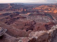
Hey Andy- how was the trip? Are you going to write it up? I watched the USGS flow reports during the ten days you were out and the river was high (22,000-28,000 CFS) the whole time. Any idea what the typical or range of current speed was? We are taking a group of boys down the section above your trip (Crystal Geyser to Mineral Bottom 63 miles) on 6/14. The Colorado was running at 6MPH in the flat water section through Moab few weeks ago when it was at 23,000 CFS. I paced a log floating down as I rode my bike along the river trail and got a good GPS reading. We are planning on 3-4 days on the river, which should be doable at the current flow level. Did you end up spending more time hiking and hanging out than paddling? Any bugs? Wind problems ? Thanks for any info and I liked your photos.