• Happy Marine Mammal Rescue Day! 🐳🐬🦭🦦

FRENCH RIVER 2022: Lake Nipissing to Georgian Bay

Joined
Mar 16, 2022
Messages
33
Reaction score
46
ACCESS POINT START : Lichty’s Marina (Sucker Creek Landing)

ACCESS POINT FINISH: Hartley Bay Marina

# OF DAYS / NIGHTS: 7 D / 6 N | DIFFICULTY LEVEL: Advanced

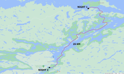
TOTAL KM: 184.5 KM | # OF PORTAGES (DISTANCE): 6 (2.2 KM)

1709736317110.png

During the winter months we had decided to plan and execute a weeklong trip somewhere other than Algonquin during the summer of 2022. The last time we had switched things up was in August of 2019 when we spent a week in Wabakimi. For a few years we had been tossing around the idea of completing the French River from Lake Nipissing right through to Georgian Bay. We had a very loose plan in place for the trip when we attended the outdoor show in the spring of 2022. After listening to Kevin Callan talk about the area, we firmed everything up in our minds and got to work planning.

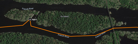
The logistics for this trip were very different from our usual weeklong trips. We are familiar with Algonquin Park and how to access and navigate its many canoe routes. We knew little about the French River, so plenty of research was required. We started off by ordering various French River maps. Unlostify (now Maps by Jeff) has a decent West French River map, but this only covers the bottom end of our trip and would not suffice on its own. The Ontario Parks French River map is much more useful for the type of trip we were planning, as it covers the entire French River including the top end North of Restoule PP.

1709736377839.png

Once the maps were in hand the next step, like all trip planning, was to grab a bottle of Lagavulin 16 and figure out where we wanted to go. The first few things we noticed about the area were the absence of portages of any real distance, the amount of paddling we would need to do on large water / into the wind, and the lack of trees towards Georgian Bay. The plan was for Rich and Ryan to paddle together, with Evan paddling solo if a partner could not be found. All three of us were going to be bringing our Hennessy Hammocks. The open water paddling was worrisome and could be a real showstopper if the weather was uncooperative, especially for Evan paddling solo. We would need to plan some buffer time into the trip to accommodate. The requirement to have trees for hammocks could also lengthen our days if we spent additional time searching for a suitable campsite. The sparsity of portaging was the cherry on top! We could pack heavier than normal and bring more beverages! We measured out a trip on Google Maps using 25-30kms per day as a baseline and determined that a Saturday-to-Saturday trip (eight days) would be enough to complete the 184.5 KM trip we had in mind. This was basically one day longer than we would need with ideal conditions, plus we would have the Sunday as some additional buffer in case things went sideways. There were going to be some long days and early mornings, but we were all quite excited. We booked the time off work and Rich started making the dehydrated meals we would require.


Another big difference we found when planning our trip was obtaining the backcountry permits. Normally we would obtain our permits 5 months in advance through the Ontario Parks online reservation system. The French River is different in that you cannot book more than 2 weeks in advance, and it is done under the “Back Country Registration” tab. You also need to book your campsites in 1 of 9 camping zones! There are several entry points listed, but everything really hinges around these zones (Note: The campsite numbers on the French River map correspond to what zone they are in. We did not really think of this until we had already booked. It would be helpful when planning as there are obviously no markers on where the zones start and end on the map, we used the website to guess!). Since our trip was going to start on Lake Nipissing, we also had at least 1 night where we would be out of the park. When ordering permits in the back country registration section it allows for this, you just need to select “Out of Park” in the “Available Zones” drop down.

1709736399687.png
1709736407332.png

1709736413347.png
We set a reminder in our calendars for mid-July and would come back to permit purchasing then. It was stressful moving forward with trip planning not knowing if we could get permits to accommodate our trip plan. Luckily, we had no issues booking our permits in July and when on the trip we found that the campsites were predominantly vacant, especially East of Recollet Falls.


The hardest part of the trip planning was working out how to pull off a nearly 190KM one way trip in an area of the province we had no experience with. We would need multiple vehicles to get boats, gear, and bodies to where they need to be, requiring a lot of shuttling. Since we live over 5 hours away from the park, we also wanted to find a place to sleep the night before disembarking. Finding a suitable place to stay proved to be more difficult than expected, as we were planning to enter the park on the Saturday of the long weekend in August! There are few major cities or towns close by, and most places to stay are “resorts” which require multiple nights to be reserved on the long weekends. We also needed to select an access point with parking for one vehicle, as well as a takeout point with parking for the second vehicle. After about two weeks of web browsing and phone calls we were able to set up a nearly ideal plan.

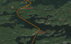
We would drive up after work on Friday and stay one night at a small motel in Alban, ON called the Riverdale Resort. Alban is essentially located halfway between the two access points we were going to use. We chose to start our trip from Lichty’s Marina, which is located off Shuswap Road on the West Bay of Lake Nipissing. We called the owner, Phillip, who was quite easy to deal with. Parking is available and only costs $5/day on an honour system (fill out a form, add money to the provided envelope and leave it in the drop box) and most importantly we could drop and pick up vehicles at any time of the day or night. We chose Hartley Bay Marina as our takeout location, which did have restrictions on operating hours (0700-2100 EST on Fridays and Weekends) and would cost $14/day for parking. We didn’t search too hard for an alternative as this marina is easy to get to and is located exactly where we wanted to end our trip.

Now that everything was planned, all we needed to do was sort everything out with work and families and wait for our departure date. Unfortunately, Ryan had a family emergency the morning we were set to depart which forced him to miss the trip. It was a tough decision for Ryan to make, but ultimately once the trip starts it is hard to pull the pin and come home from such a far distance away. We did some last-minute gear, booze, and food reduction to account for one less human, and hit the road around 1600 EST. We only had one canoe now, but still needed to drive up in separate cars to pull off the multiple shuttles. We arrived shortly after 2100 EST in Alban and checked into the hotel.

1709736428706.png
Belleville to Riverdale Resort (Alban,ON): 446 KM (5 Hours 14 minutes)

1709736437498.png 1709736441594.png

The room was small, but we were only going to be sleeping there for 4-5 hours anyways. We headed down to the bar at the hotel to meet and greet the locals and then started our first leg of shuttling. We wanted to leave Rich’s car at the top end, and the truck at the bottom end so it was ready to load once we finished. The first thing we needed to do was get the canoe to Lichty’s Marina, which we did on Friday night.

1709736452819.png

It took us around 50 minutes to drive to the dock, stash the canoe beside the boathouse, and drive back. We were back to the hotel and ponied up to the bar sucking back Exports before 2300 EST. A few hours later, and about half of George Strait’s greatest hits, we figured we should call it a night. It was going to be an early morning, a long day, and some wicked hangovers!

Daily Trip log to follow...
 
Day 1 : Lichty’s Marina to Lake Nipissing (South of Sandy Island)

TOTAL KM:
30 KM | # OF PORTAGES (DISTANCE): N/A

1709737198993.png

We woke up at 0530 to a loud alarm and headaches. We both grabbed a final shower and hit the road. We needed to get the truck to Hartley Bay, grab some breakfast, and drive to Lichty’s. Hartley Bay Marina opens at 7am, and we planned to be there as soon as they did. We arrived, entered the main gate house and paid for a weeks worth of parking. They have a parking attendant on a golf cart that takes you back and directs you on where to park. Once the truck was safely stowed for the week we headed back to our hotel to order breakfast for the road. We both got some sort of egg breakfast wrap with home fries. We then headed back to Lichty’s to finally end our morning commute.

1709737179914.png
Total Drive: 84.5 KM | Drive Time: 1 hour 17 minutes

We had made it. We were at the launch point with all of our gear, the canoe, and all the preparation work was over. It was time to leave the parking money in an envelope, and hit the water at long last. We loaded everything into the canoe right at the Lichty’s dock, which is located in a secluded bay. We had no view out into Lake Nipissing, but the morning was calm so we anticipated good paddling conditions. It was also a very sunny morning, and looking back we should have really loaded up on the sun screen. A full day out on the lake, in the blazing sun, after a few too many beers the night before… recipe for a rough night!

We paddled out of the bay, swung the canoe to the East and started our long paddle. The first section of Lake Nipissing, West Bay, has lot of islands on the Southern shore so it doesn’t feel like a huge body of water. We picked our way through the smallest islands, and made sure to round the largest islands on the correct side. When paddling on large water it can sometimes be difficult to determine distances, and if the large pieces of land are in fact islands or bays and points.

We made great time and eventually made our way to Lafleche Point, almost the halfway point of our day. We stopped and ate lunch on a rocky whale’s back point with a tremendous view of the lake. Rich surprised me with an extra surprise in our bag lunch today… a small can of Pepsi and a sample bottle of whiskey! Hair of the dog, like they always say. As we sat there, eating trail mix and sipping our drinks, the prevailing wind started to build. We would be wind assisted the rest of the day if the wind held, which would be fantastic. We did worry about the wind picking up any more though, as neither of us wanted to be riding massive swells on such a large body of water. We hadn’t even made it to the main lake yet.

With this worry in the back of our minds we pushed off from Lafleche Point and continued our way Eastward. The next landmark is the narrowing between West Bay and the main body of Lake Nipissing. As the lake narrows through this natural channel the wind and the waves grew. We also started seeing navigational buoys for the boat traffic flying in and out of the gap. Several boats passed us a little too close for our liking. The boats were pounding into the wind and waves and we figured they likely couldn’t see us very well given the conditions. It was also precarious to be riding the swells and having to deal with boat wakes rocking us further. We slowly made our way towards the North shore of the channel, crossed over the buoys, and paddled through the chain of islands to avoid potentially capsizing or colliding with a boat. We pulled up to one of the last islands to stretch our legs and to take in our first view of Lake Nipissing. The island was small, with a predominantly rock ground covered in plenty of lichen. There was a small copse of trees in the middle, which we walked through to get some shade. We found some old cans, pans, old buckets, and a couple of rock fire rings. I wouldn’t want to camp on this spot, as it is very exposed to the elements, but it would make a nice spot to eat a shore lunch. We spent some time looking at the map and getting our bearings. The lake is huge, and sitting there staring out felt a little overwhelming. The lake looks calm, until your brain wraps itself around the distances you are staring at. The far shore (North Bay, ON) is 50 kilometers away Most of the shoreline is just a slight green smudge on the horizon. We could see small islands, mostly treeless lumps of rock, dotting the blue occasionally, and not even on our map. There is even a lighthouse in view… you know you are on big water when lighthouses are involved!

1709737156105.png

1709737163876.png

Our plan was simple enough. Keep as close to the Southern shore as possible, use as many islands as we could to take a break and set new landmarks, and keep the open side up. We cut through the narrow gap by Hidden Island Camp and were greeted by several groups of people sitting on docks or decks. One group of guys offered for us to join them and have a beer. Looking back, we should have, but we politely declined and pushed on. We aimed for the bottom end of Cote Island, then angled up and over the next large point. Thankfully the wind never did pick up, and provided us with a nice manageable tailwind the entire way. As we approached Jennings Island we noticed a strange looking island in the distance. It was your typical “mound of smooth rock jutting out of the water” type of island, zero trees, but with what looked like hundreds of flies buzzing around it. As we drew closer, we noticed the entire island, sky, and surrounding water were filled with gulls and cormorants. Against our better judgement we decided to paddle as close as we could to this seething mass of birds without getting dive bombed or pooped on. The air was filled with the sound of sea birds shrieking, and splashes from the cormorants bombing the water for fish. It was a really neat experience, and surprisingly neither of us were crapped on!

1709737130929.png

We were now on the home stretch, and could see the big green smudge of Sandy Island growing in front of us. We wanted to make camp somewhere South of Sandy Island, which would let us enter the French River the following day. We pulled over one final time on a rock point just West of Wigwam Bay. We hydrated, checked the map, and poked around for artifacts. We found more fire rings, some sort of old rudimentary wooden sleigh, and our first snake of the trip! Rich is NOT a big fan of snakes… he is actually petrified of them. As we were walking around the shore we stumbled on a few big water snakes in the grass. One quickly slithered down to its hole just above the waterline, while the other one swam away into the tall grass. Once we ran into the snakes Rich made the decision to load up and move on rather quickly. I pointed out to Rich that these were just water snakes, and not the Massissauga Rattlesnakes that can be found in the region. I don’t think this helped, and merely reminded Rich that there could be poisonous snakes in our near future!

It was late afternoon, with the sun and wind at our back as we approached the gap below Sandy Island. On our map it looked like a large clear opening, but as you approach you realize it looks more like a grass filled bay. The lake gets very shallow and the entire gap appears to be an unbroken wall of grass, too thick to paddle through. We elected to try our luck by swinging south towards Wigwam Point. There is an opening that allows you to pass where Wigwam Bay opens up into the lake. We made sure to listen and scout for boats before emerging from behind the grasses. In looking at satellite views of the area you can clearly see the vegetation, and the large channel that runs much further to the North where most of the boat traffic tends to go.

1709737111279.png

1709737115472.png

We noted that two of the islands in front of us had man made structures of some kind, but the long skinny island behind them appeared to be unsettled. We split the first two islands, noting that no one appeared to be at the cottages currently. We did a quick circle of the third island, making sure no one else was camped yet. We were in luck, the island was empty, so we pulled up on a smooth rock shore on the backside of the island. We did note that a piece of wood had been chained to the shore just below the waterline… at the time we had no idea what it was used for. We would learn in the morning though. We walked around the island to find a suitable place to hang our hammocks and to set up our fire and chairs. The hammocks went closer to the take out in a small stand of trees, while the firepit was set up on the North side of the island. We wanted to take advantage of the wind off the lake to keep the mosquitos down, and to give us a nice sunset view while having supper. We cooked up our steaks and twice baked potatoes for dinner. We then hunkered down into our camp chairs and poured a few well deserved beverages. We also realized that due to our proximity to North Bay, we had cell reception still! We put on some George Strait and Garth Brooks and watched the sky fade from blazing orange, to deep purple, to a star filled black sky. In planning this trip the first day had been one of our biggest worries. It was a full day (30+ KM) of big lake paddling and we didn’t want to be wind bound or delayed before even making it to the French River. Our first day could not have gone any better, so we went to bed feeling very fortunate and accomplished.

1709737093996.png

Day 1 Video:
 
Evan, that's an impressive amount of documentary and editing work—writing, maps, photos, video. I read and watched it all. Looking forward to the rest of the days. I'd be interested in description of your boat, paddles and other gear, and, after the trip, how you evaluated it all.
 
Evan, that's an impressive amount of documentary and editing work—writing, maps, photos, video. I read and watched it all. Looking forward to the rest of the days. I'd be interested in description of your boat, paddles and other gear, and, after the trip, how you evaluated it all.
Thanks for taking the time to check this out. I wanted to put some French River content up for some time now, and include the logistics and planning steps we took to pull it off. Hopefully it will help other people that are on the fence about heading up that way. I read the other trip reports on this forum all the time, and I enjoy when people include the travel to and from the trip in their reports. I like to know how to pull it off myself one day.

We have used a 16-6 Langford Prospector (Kevlar) for the last decade. She has held up really well.
We typically trip in Algonquin, which has very limited white water and tends to be portage heavy.
This trip really should be done with a more robust boat, as the portaging is nearly non-existent.

The paddles we are using are from Red Tail Paddles. This is a paddle company just north of our home town.
I use a Black Walnut Ottertail and Rich uses a Laminate Ottertail.
They do custom engraving/personalization, so we attended their factory.
Met the owner, nice guy, and got them to add our logo to them at a very reasonable price.

We hammock camp, and have used Hennessy Hammocks for over a decade (Explorer Deluxe, Asym Zip).
I upgraded the fly to the HEX model, which adds weight but is worth it during the heaviest of rain.
We have some cheap under quilts from Amazon to add some warmth under our backs, which goes a long way in the comfort department.
On this trip, we brought a cheap 2 man tent as well, just in case.
Looking back, this could have been left at home as it stayed in the bottom of my pack the entire trip.
Once you sleep in the air, it is hard to sleep on the ground again!

If you have any other specific questions let me know.
 
Day 2 : Lake Nipissing to Portage Channel Dam

TOTAL KM:
25 KM | # OF PORTAGES (DISTANCE): 1 (580 meters)

1709826010635.png

We woke up to another spectacular morning. Lake Nipissing was calm, and the sun was shining. It was going to be another sweltering day. Both of our arms and faces were already showing the effects of the sun from yesterday, especially Evan’s nose, lips, and neck. We had egg wraps for breakfast and washed it down with a pot of coffee while packing up our gear… mindful to apply sunscreen and leaving it accessible for later as well. As we carried our gear back to the canoe, which was on the South side of the island, we heard a boat approaching and a dog barking. It was a man in a fishing boat, with his pooch proudly riding the bow like a canine figurehead. The boat landed on the island, using the submerged wood plank to protect the hull from the shore rocks… smart, now we know why this board was installed. We greeted the man and watched the dog leap out and bolt into the woods. The captain of the vessel was “Berent” (sp.). He uses this island as a resting spot while fishing, allowing his dog to relieve himself. Berent was curious about our trip and was excited to hear we were headed all the way to Georgian Bay. He gave us some tips on the route, spots to fish, and in hindsight gave us an exceptionally overblown warning about black bears. Leaving the conversation, we were now expecting to see droves of aggressive bears on every shore (Spoiler: we did not see a single black bear the entire week).

We said farewell to Barry and pushed off with plenty of enthusiasm. We were a little over 3km from the start of the French River. We were excited to be off the big lake and start heading in a W/SW direction. As you approach Canoe Pass you start to see one of the downsides of backcountry camping on the French River. This route has plenty of cottages, homes, and boat traffic, especially in the Northern section. Some buildings are shacks, and some are multi-million dollar mansions with elevators installed on the shorelines to transport people down to their docks. We could only imagine owning a property on such a beautiful piece of land, on such a historic waterway. I would find it hard to ever leave.

We left Lake Nipissing and entered the Canoe Pass. There are plenty of signs to warn everyone about approaching boats, and speed limits. We were cautious and made sure to scout before slipping into the 20-meter-wide channel. After a full day of big lake paddling, it felt strange to be surrounded so closely by forest on both sides again. It was also strangely quiet in the channel, compared to the ambient noise on the lake. We emerged into a small section of river where we saw the first French River Provincial Park campsite marker (on the right side) and our first passing watercraft. For most of the trip, especially the next couple of days, we would deal with hundreds of watercrafts of diverse types and sizes. This is not something we are used to seeing, and it would take some getting used to.

Our next landmark was impossible to miss, the 9-storey tall Gibraltar Rock. This channel is like the Canoe Pass in that you need to make sure no boat traffic is screaming through before entering. We were lucky, and no one was approaching in either direction. We paddled right to the base of the rock, and slowly made our way down looking for any pictographs. We hadn’t read any reports of pictographs on this rock, so we did not expect to see any. We did see some recent graffiti though, which was unfortunate. The rock also afforded us some much-needed shade for a few minutes. In the channel we also started to feel the bane of our existence for the next 4 days, the good ole prevailing wind. It was not very strong, but like always we were anticipating the wind to build through the late morning. It would be something to contend with later this afternoon, and for most of our trip.

1709825970196.png
Our next stop was the pictograph location on Kennedy Island. We had read about this site and we were looking forward to seeing them for ourselves. We planned to head around the North side of Elliot Island and then pass Kennedy Island on the West side. We were about halfway to the pictographs when the familiar drone of a float plane started. It sounded like the plane was flying right towards us, and sure enough, the plane popped into view over Crowe’s Rest Island and descended right over top of our canoe. It was a neat experience and reminded us both of our float plane drop off in Wabakimi three years prior. We rounded the top of Elliot Island and paddled the small channel towards the pictographs, finding the plaque and indigenous paintings easily. I am not sure why someone decided to mount a bronze plaque so close to the pictographs… other than the rock they are both on is quite flat.

1709825928658.png
1709825934838.png
1709825943108.png
The variety of shapes depicted, as well as the clarity of some, is quite striking. We are not experts in Indigenous art, but we do enjoy trying to find pictographs and then interpreting them to the best of our abilities. This one looks to include a wolf, bear, fish, bird, and multiple stick people (or trees). We cut our experience a bit short, so as not to intrude on the people riding SUPs in the channel beside us. It should be noted that there is a cottage, with a dock, essentially right across from these pictographs. You will most likely have company as you enjoy the art.

We paddled on the South side of Elliot Island for the rest of the morning. The wind was building slightly, and the boat traffic increased. We passed many people on their docks. It was Saturday of the August long weekend; the entire river was alive with people. When we reached the end of Elliot Island, we decided to swing over to the North side of Bragdon Island to hopefully get some respite from the wind and crowds. We also started looking for a spot to pull over and eat lunch. We settle on a marked campsite on an island just West of Bragdon Island. We climbed out of the canoe up on to a large piece of Canadian Shield and enjoyed our usual bagged lunch (no whiskey today!). We gravity filtered some water and pulled the maps out to decide our plan of attack for the rest of the day. The river gradually widens until you get to Dokis Bay and the Okikendawt Hydroelectric Dam. The wind was also gradually increasing as the day wore on, we could feel it growing even as we sat eating lunch. We decided to stay in the series of large islands off the North shore of the river (Drunken Island, Hunt Island, Comfort Island etc.). We would be travelling a further distance, but we would stay reasonably protected from the worst of the wind most of the day. This would eventually leave us with one or two large crossings at the end of the day to get us onto the final portage.

1709825910579.png
We finished lunch and headed around the North side of Drunken Island, split the next two islands, and worked our way out to the gap between Hunt Island and the Hammond Islands. We stopped to stretch our legs on a small rock island in the gap, checking out the open water leading to our next destination. We decided to head on a slight angle from our current location to the small island between Comfort Island and Metapedia Island. It appeared to not have any buildings or docks, and would be another good spot to scout from. We rounded the corner, squared up with the wind and started slogging. The wind was constant but not overly gusty, so the going was slow but steady. As we pulled into a small bay, and started climbing up on to our scouting island, we noticed a group of five or six children swimming and jumping off a dock on Comfort Island. To be young and carefree is one of life’s greatest gifts.

From our elevated perch, we had an expansive view of our afternoon’s worth of work. A strong head wind was blowing by this point, and this crossing would be the longest. We both cracked a cider to whet the whistles, and to settle our nerves with some liquid courage. The plan was simple, head out towards Perkins Island, then towards two small rocky islands SE of Pineknot Island. Finally, we would then duck behind Wright Island, stopping to rest in the leeward side of each island as required. The wind direction and speed was unlikely to change too much during our crossing, so the only unknown was the boat traffic we would be contending with. There are countless dwellings on the river, but there are also several resorts , lodges and a small First Nations community at the end of the bay. The boat traffic was constant, with all manner of pleasure craft, fishing boats, house boats, and pontoon boats passing every which way. We even had what appeared to be a jet ski race fly by us once we rounded Perkins Island. Once we were in the open between Perkins Island and Wright Island the waves were the largest. Rich was in the front of the canoe and several times he was tossed high into the air, eventually crashing down in a spray of water. We only took on a small bit of water, but Evan was soaked from bow spray. We had another dodgy moment when the wake from a pontoon boat took us from a weird side angle during the worst of the prevailing waves. You know it is going to get rocky when the waves all around you form large pyramids instead of uniform troughs. Deep down though, the anxiety on this crossing was not that bad. The combination of sunny weather and island ciders helped, plus the constant boat traffic that caused cross waves was also a safety net. If we did manage to capsize it would not be as dangerous as a remote lake in Algonquin. We would not need to be as self sufficient, as surely someone would stop and assist two floundering beauties bobbing in the middle of the French! Alas, nothing bad happened and we made it to the leeward side of Wright Island with only sore shoulders.

1709826035016.png

The paddle past Fire Island and Rock Island was uneventful. We played with the idea of paddling into Dokis, to maybe buy some treats and worms for fishing, but decided we were too tired to paddle the extra kilometers. We headed South passed the Tilted Toque Wilderness Resort, and towards the hydroelectric dam. The map we were using was not the greatest, and the end was somewhat confusing. There are essentially two directions to travel, with a series of islands between them. The rightmost channel has a dam at the end, but if you paddle through the islands the Okikendawt Hydroelectric Project dam comes into view. Stay to the left, past the dam and the orange buoys to the Southernmost end of the bay. As you approach you will eventually see the portage take out.

1709826052885.png

It was strange to be over 50 kilometres into a trip without having to do a single portage. It was almost nice to have the canoe over our heads for once… obviously not Rich’s head. The portage was reasonably flat, with a slight incline up to where the portage crosses Keso Bay Road. From there it is downhill, working over some flat boulders and eventually exists back to the river at a fantastic campsite. The Chaudière Rapids run to your right (no fish were caught), and the French River looks more “remote” on this side of the dam. We elected to not stay at this campsite, to avoid other groups having to march right through our site. By the time we finished fishing, (or more appropriately, catching snags) the sun was dipping towards the tree line downriver. We elected to camp on the North shore just down from the rapids. The site consisted of a nice wide rock frontage, with a cleared gravel trail back into the woods. It became very obvious once set up that there would be the occasional vehicle passing behind our campsite. This tarnished some of the allure of the river. We were not unhappy though. We had completed another big day, mishap free, and were now getting deeper into the heart of the French River. We cooked up campfire pizzas (what a treat!) and sipped on some beverages while sitting around the fire.

1709826063976.png

The river was calm, with loons calling out most of the evening. We were finally “camping”, and the excitement to get closer to the “Five Mile Rapids” section of our trip was building. We stayed up long enough to see the stars come out, on a crisp cool night. A few final vehicles went by in the distance, then we settled down to a quiet nights sleep.

Day 2 Video:
 

Attachments

  • 1709823249595.png
    1709823249595.png
    518.7 KB · Views: 3
  • 1709823230615.png
    1709823230615.png
    467.5 KB · Views: 2
  • 1709823220459.png
    1709823220459.png
    388 KB · Views: 1
  • 1709823193643.png
    1709823193643.png
    895 KB · Views: 2
  • 1709823144212.png
    1709823144212.png
    593.1 KB · Views: 3
Day 3 : Portage Channel Dam to Crooked Rapids

TOTAL KM:
25 KM | # OF PORTAGES (DISTANCE): 4 (0.62 KM)

1709907417904.png
We woke up to a noticeably quiet morning, with the mist rising off the river, and the sun peeking over the tree line. This is the type of morning we had been waiting for, and it was at this moment we felt our French River experience really began. We started a fire and cooked up our standard breakfast of eggs and bacon on tortilla wraps. As we were finishing up, the sun finally rose high enough to bathe us in its warm rays. We were content and excited to see what the day would bring. This was likely to be the day where we took on the most rapids (or portages) of the trip. Our goal was to run as many rapids as possible and camp somewhere on the South side of Eighteen Mile Island.

1709907431132.png
We left camp shortly after 0900 and our first landmark quickly came into view. We had read about the pictographs on river right at the Keso Rapids. The portage around this “rapid” is on river left, but as we approached, we didn’t see a reason to use it. It was at this moment that we started to get a real indication on just how low the water levels were on the French. Usually, you can hear fast moving water as you approach a “rapid”. We heard nothing but the morning chatter of birds, and our own paddle strokes. We were able to paddle with ease through the narrow opening at the Keso Rapids and stopped on river right to investigate the pictograph (which is easy to find, some 8-10 feet above our current water levels under a juniper bush).

1709907456189.png

We then paddle on, rounding Boom Island on the North side, and entered a wide section of the river where Restoule Bay spills into the French. The river was still calm, so we sat and scanned the shoreline for any signs of wildlife. We were hoping to see moose, or maybe even one of Berent’s numerous black bears. We saw only waterfowl and possibly a canoe full of campers far in the distance, it was too far to be sure. We had toyed with the idea of starting our trip from Restoule Provincial Park, instead of risking the larger waters of Lake Nipissing. By the time we investigated it more seriously, we found out that it would not be possible. The park was booked solid on our first day of the trip, plus there was a warning that travel down the Restoule River was severely limited due to the low water levels. Looking back, it would have made the car shuttling even more grueling as well. This would be another option when starting a trip like ours, with the connection of the two parks being just past Dokis.

1709907479501.png
The next section of the river was not particularly memorable. We passed South of Georgia Island, and North of Huntington Island. We were passed by several small aluminum fishing boats with sole occupants. None of which slowed down or even acknowledged our passing. Occasionally, you see on the shoreline a small building or dock. None of these were full scale mansions like we saw at the mouth of the French. These were more rustic looking cottages or fish camps. We crossed through the Chaudière Channel and started looking for a place to stop for a stretch. We picked a small island with a campsite, just east of Fish Fry Island, to pull over and hydrate. The campsite was fronted by a massive, multi-level whale’s back, and included a bush crafted kitchen and bench. We poked around a bit, found the thunder box, and concluded that the site was suitable for habitation. We tried our luck with some fishing in the small bay beside the site, but nothing was biting.

Once we were hydrated, with adequately stretched legs and backs, we loaded up and continued our way West. After passing another series of islands the river opens quite a bit at the end of Okikendawt Island. The Northern Channel empties into the main channel here, via the Five Finger Rapids. What this meant for us, with a slowly strengthening wind, was our first open water crossing of the day. The wind and waves were nothing compared to Day 2, but served as a reminder that we were indeed heading constantly West, and parts of the French feel more like a lake than a river.

We eventually made it to the next series of islands, split those, and entered one of the river’s main hubs. We were at the Easternmost point of Eighteen Mile Island, which effectively splits the river into two channels. This is also where Wolseley Bay enters the main channel, which leads up towards the town of Monetville and beyond. There are plenty of lodges and resorts in this section, mostly up Wolseley Bay. This would be another option for starting your trip, if you elected to forego Lake Nipissing and the busy Northern section of the French. We headed South at the junction and made our way towards the Little Pine Rapids. As we approached the portage, it became obvious that this spot was heavily used for sightseeing and apparently picnic lunches. I can’t blame the other people, as we did the same thing! We pulled our boat out at the top, grabbed our bag lunches, and sat on the rocks enjoying the view. Some small children were fishing in the channel, other groups were portaging up the rapid, and plenty of people were sitting in groups chatting. This is not something we would normally experience on a trip, 20 - 30 people gathered in one spot. The sun was out, everyone seemed to be enjoying themselves, so it was still a memorable moment. The rapid itself looked like it could be fun to run… in the spring or fall. There wasn’t enough water to risk the Kevlar hull of our canoe, so we elected to line the boat. With the fishing children watching, we successfully tossed the boat through, and loaded up on the downstream side to ride out the last bit of fast-moving water. We wished them good luck in their fishing endeavors and resumed our paddle. Immediately, we were slammed with the strongest headwind of the trip so far. It was now afternoon, and the wind was up. Coming out of the rapid we were in a narrow, rock walled channel and the wind was funneled and substantial. Even with the increased current pushing us from behind we were barely making headway. We continued our slog into the wind until the next set of rapids, the Big Pine Rapids. The portage is to the right of the rapid, so we pulled over and scouted. There was more water running through this set, but it still looked too shallow and boney for us to run. If we had a more robust boat, we might have tried our luck. Instead, we completed the up and over P170. The downstream end of this portage is not ideal during low water. It is a rock garden for approximately 10 meters, and this also extends well past the waterline. Care needed to be taken to not twist an ankle on our way to the water carrying the canoe and made loading and entering the boat a tad tricky. Rich also saw another snake in the rocks… which didn’t brighten his mood.

1709907522443.png

As we paddled up to the Double Rapids, we noted a bright tent on a large rock outcrop on the left side of the river. There was an adult male processing wood by the firepit, and two young boys in life jackets jumping off the rocks into the water. They were then floating down the river, and through the rapid. We pulled over on the riverbank to let them clear the rapid, and to scout our route. The right side of the “double” rapids had plenty of rocks and looked far too shallow to run. The left side was our best bet, with all the water flowing through a medium-sized gap and no obvious obstructions. It did have some large standing waves on the exit of the rapid, but nothing we couldn’t handle. The boys saw us waiting, and once they were clear of the rapid and on shore, we started our run. We cleared the rapid without issue, just some small spray as we slammed our way out of the standing waves. Even a small rapid can get your blood pumping. With a wave to the kids, we were off again. I hope those boys know how lucky they are. To live in a country with such amazing wilderness, and to have an adult figure willing to expose them to it.

1709907569893.png

Next up is the option between “The Ladder” and the “Blue Chute” around Double Rapids Island. Honestly, I don’t know why we chose to tackle the former and not the latter. We pulled up to the P190 and instantly realized that running or even lining this rapid was impossible. It is a boulder garden of epic proportions! We carried our bags and rods over the portage and decided to take the boat and paddles around the rock shelves on the opposite shore. Variety is the spice of life, I guess. As we tackled this obstacle the first rain of the trip started to fall. One minute it was bright and sunny, the next it was black and raining. Now we know why the headwind had picked up so drastically at Little Pine Rapid! By the time we paddled over to get our bags at the put in, we were thoroughly drenched. Once done with the Ladder, we swung the corner to check out the Blue Chute. We could have avoided our 40-minute ordeal at the Ladder by just gently paddling around the corner through the low water Blue Chute. Oh well, we had our experience and no regrets, and the next rapid/portage was waiting.

The next two rapids are aptly named for the French River. The Little and Big Parisien Rapids. We started with the Little Parisien, and almost ran this one in error. The lead up to this rapid takes you through a deep channel with high rock walls. Once you enter, the current picks up rapidly and pulls you in. Thankfully we realized that the rapid was closer than we thought, and back paddled as hard as we could out of the channel. We put in at the P160 on river right, climbed over the large boulders at the takeout, and walked downstream to scout. Of all the rapids, this one likely could have been run. It had a large amount of water, but it would require a quick turn to the right mid rapid to avoid some partially submerged rocks. These rocks would have been hard to see from water level, and likely could only be seen from above. We wisely chose to carry the portage, leaving a nagging thought in our minds..., could we have handled this one? We also have a Kevlar canoe, which is not ideal for running rapids. Should we invest in a more robust boat? The portage ends at a wide, flat, rock shelf where the rapid spills out into a dark pool. The rain had left off slightly while we portaged, so we stopped to fish at the bottom of this rapid. We managed to catch a few Smallmouth Bass. Our respite from the rain was short lived, and once it started again the rain was falling even harder.

The rest of the day blended into one big, rain-soaked blur. We never did lay eyes on the Big Parisien Rapid. We paddled around Big Bluff Island and then took the Devil’s Chute, which was not very scary in lower water. Just a slight quickening of the current. We put our heads down and paddled into the driving rain, looking for a suitable place to camp. There was a campsite listed on the map by the Crooked Rapids, so we pushed for that. We pulled up on shore to check out the campsite and found it to be unsuitable for hammocks. It was mostly open rock, and where there were trees, they were so tightly packed together a human could not hang between them. While checking out the site, we realized that the Crooked Rapids were as exciting as the Devil’s Chute… not exciting at all! The next promising campsite was in the next chain of islands, East of Cross Island. We wanted nothing more than to stop for the day and get into dry clothes to warm up. Begrudgingly, we hopped back in the canoe, pushed off and waggled our way through the Crooked Rapids. We were through the Five Mile Rapids and hopefully only had a few more kilometers of travel for the day.

The island campsite came into view… and it was unsurprisingly unoccupied. We had only seen one group using a campsite the entire trip. As we pulled up to our home for the night, we realized we would need to be creative with our tarp and hammock set up. The island was very rocky… everywhere. There were a limited number of trees, and most were either too close together, or too far apart to be of use. We managed to find two spots for our hammocks, though far from perfect. In a little hollow, at the top of a hill, we set up our tarp and kitchen. We were off the water, huddled under a tarp, in dry clothes, and sipping on scotch. The party morale started to increase.

Rich and I had struck a deal earlier in the trip. I would make breakfast every morning, and he would make dinner every night. I am sure he enjoyed sleeping in a little later each morning, while I cooked. On this night I certainly enjoyed sitting there, sipping my beverage, while he cooked supper and grumbled under his breath. Our planned choice of dinner was likely the hardest to prepare of all our dinners, so I felt his pain (a bit). Rich had wanted to try a homemade Ramen style noodle dish, with a cooked egg, broth, onion, noodles, nuts, various spices etc. It took quite a while for Rich to make, but like always my guy knocked it out of the park. I have never been disappointed with his meal selection or prep. Soldiers march… or paddle I guess… on their stomachs!

1709907591810.png

When we were done with dinner, the rain finally let off while I was cleaning the dishes. The steady wind from the afternoon was gone as well, leaving us with a serene sunset and quiet night. We were both exhausted from several long days in a row, and since the island had limited wood (none of it dry!) we both went to bed early. We had another big day ahead of ourselves tomorrow, with hopefully nicer weather!

Day 3 Video:
 

Attachments

  • 1709907512573.png
    1709907512573.png
    705.9 KB · Views: 0
Day 4 : Crooked Rapids to Ox Island
TOTAL KM
38 KM
# OF PORTAGES (DISTANCE) N/A

1710164382574.png

We woke up to a calm but chilly morning, with plenty of colour in the sky. Certainly not a sailor’s delight! We had just experienced an entire afternoon and evening of rain, so we were not excited about the prospect of more. We also knew this was going to be one of the longest days of our trip, somewhere in the 30 – 40-kilometer range. We would be arriving at the next major hub on the French River sometime after lunch. This is where Eighteen Mile Island ends, giving us the option to head south to the Pickerel River or maintain our course on the Main Channel. Our plan was to stay on the Main Channel all the way to Wanapitei Bay, passing Recollet Falls and some pictographs on the way. While eating our powdered egg and bacon wraps, we poured over the maps and started calculating distances to the limited number of campsites West of Bon Air. If we made it somewhere West of Recollet Falls, we would consider it a successful day. With the goal for the day set and breakfast squared away, we set off again into a slight morning headwind.

1710164397533.png

Our first stop of the day was a short 10-minute paddle down river. We had read reports of the Jesuit cross located on Cross Island and wanted to check it out for ourselves. We were not sure which side of the island to check, so we half circumnavigated the island to the West side, where the large white cross is easy to spot. The cross is located at the top of a rocky hill and is approximately 10 feet tall. We pulled over near a small spit of land, clambered over the large rocks at the shore, and made the easy ascent. There is an old metal plaque with a French inscription on it. The cross was placed in 1982 by the Knights of Columbus to commemorate several Jesuit priests who are said to be buried on the island centuries before. We stood at the top of the hill, and quietly took in the picturesque landscape and the sound of the wind whistling down the river. The translation of the plaque reads:

In memory of one of our Canadien missionaries

Cross dedicated by the Reverend Father Rondeau

The 15 of June, 1982

erected by The Knights of Columbus

Noelville Ontario Council 4435


1710164414502.png

1710164420380.png

1710164425496.png

1710164433074.png

The next section of the river was beautiful but largely uneventful. The channel is wide and quite effectively funnels the prevailing wind. We did not have to work exceptionally hard, but all headway was earned. The Haystack Islands stand out predominantly as you approach, and from a distance live up to their name. They are not very big islands, but they do rise rapidly out of the water. The cottage located on one of the islands is rather neat, being precariously built into the rock slopes. Waking up and sipping a coffee from the deck would be awesome!

It became obvious that Rich was struggling this morning. Rich is normally the lifeblood of the group’s morale and humour. This morning, he was very quiet and lethargic. We discussed this briefly while paddling, and we chalked it up to overall exhaustion and likely dehydration. When you spend most of the day slogging it out in the rain, you forget to drink enough water. When dripping wet, with a shiver from the cold, the last thing you want is cold water inside you. Before we made it to Owl’s Head Island, we were forced to pull over so Rich could lay down. No one wanted a pile of vomit in the canoe. We decided to pull over at campsite 517, but found it was already occupied. We headed across the river to the North shore and pulled into a small bay. We landed the canoe on a tiny beach and made our way over to lay on some rocks to hydrate. Rich laid down and closed his eyes for a bit, and I spent my time relaxing and watching Otters play in the bay. After a Nalgene of water, and 30-40 minutes of rest, Rich was good to proceed. Not an ideal way to start our big day, but we still had plenty of daylight.

Around midday we passed underneath the high-voltage power lines that run from Barrie to Sudbury. A hawk was circling high overhead, and with no other sounds around us we could feel the hum of the EM field. Like walking into a house and feeling the TV being on. We pulled over on the North shore just past Dalton’s Point to eat lunch on an elevated campsite. Our view while eating was impressive, looking west down the channel towards Fourmile Island. We made sure to continue hydrating as well. The sun had finally decided to show itself, and the air temperature was rising.

At Lost Child Bend we turned South and paddled the South shore of Fourmile Island. Once you pass the large bay, you will see an obvious vertical rock on the right-hand side. We had our eyes peeled as we paddled by, and Rich spotted another pictograph. This one looked like two people sitting in a canoe with heavy rain falling on them. Maybe we were part of a long line of tandem rain-soaked paddlers of the French. We recorded our voyage on a camera and our historical brethren recorded it on a rock.

1710164452877.png

Once we moved on from the pictograph rock, we needed to focus all our attention on the other people around us. There is a relatively small gap on the western shore where the Main Channel resumes, but you need to paddle across some open water to reach it. There are plenty of signs for low water, speed limits, and to watch for other boats. Only the last one worried us though. The bay before the gap was a bit of a circus. There is a golf course, resort, and tons of cottages in this section. There were boats, jet skis, and even a teenager waterskiing around us as we made our crossing. That kid could really waterski! By the time she looped back around for the second time she was skiing slalom, and was just crushing it! We were happy to make it back into the Main Channel, but we were still aware of the danger of passing boats. We stuck as close as possible to the right-hand shore to mitigate any potential collisions. There are no bones about it, this part of our trip had zero feelings of being remote. This was one of the reasons for our long day plan, we needed to get away from these crowds ASAP!

But first, we wanted to treat ourselves to something cold and sweet from the French River Supply Co. In the middle of the “Land of many bridges” (a train bridge, two old highway bridges, a new road bridge, and the visitor center pedestrian bridge all in a 1.5 KM stretch) is a small marina tucked into a bay on the right-hand side. We paddled up to an open dock as far into the bay as we could find and tied the canoe up by the bullrushes. We grabbed our wallets and cell phones and headed over to the small store. We chatted with the store clerk a bit as we browsed the shop. We settled on batteries, ice cream bars, bags of chips and some pop to be used as mix in the coming days. We also bought some French River patches for the collection. We sat out in the beautiful afternoon sun eating our ice cream, just two lads with nowhere to be, enjoying a summer day. While sitting there, we did see a handful of boys being boys behind us. They were catching water snakes from the shore and showing each other, which horrified Rich. This fun ended when one of the kids received a nasty bite, which seemed liked the only logical result from Rich’s perspective. We chatted with their parents for a short while, they were enjoying a summer vacation at a rented cottage close by. We also posted an update of our location online and checked the local weather for the coming days. The app was calling for heavy rain and storm conditions the following day… the cottagers we were talking to also confirmed the forecast. It was well into the afternoon, but it was at this moment we decided to really push to get ahead of schedule. If we could paddle until sunset, we could choose to not travel in the rain the following day if we didn’t want to.

1710164466226.png

1710164518251.png
We left the marina, bellies full of sugar and with energy to spare. Once you pass under the four bridges you find yourself in a steep rock walled channel leading up to the largest waterfall on the French River, Recollet Falls. We paddled slowly, trying to find the pictograph on the North shore. Since water levels were so low the current was not amazingly fast, but it was noticeable. In spring, or in a high-water situation, I imagine the lead up to the falls would be more dramatic and cause a lot more stress. As you approach, the sound of the falls grows and becomes quite loud due to the echo on the surrounding rock walls. We did manage to locate the very faint pictograph, which looks like some sort of Nanabozho being similar to the pictographs at Bon Echo Provincial Park. We considered ourselves lucky to find it, I bet most people can’t get this close to the falls in typical water conditions. The portage is on the left side of the river and is located very close to the top of the falls. We pulled into the rock shore without issue, and single carried to the other side. The portage starts out very steep and sandy, but once you reach the top it opens onto flat tabletop rocks with a magnificent view of the falls to your right. When you are starting your descent, watch for a small gap in the sumac to your left. There is a small, unmarked trail that will take you to the put in at the base of the falls. We loaded the canoe and tucked it out of the way for now. We grabbed our fishing tackle and rods and climbed up to the top of the falls to fish back into the pool below. We met a young Indigenous man who was packing up his fishing gear and about to head out. We chatted for a bit about the fishing conditions on the French, as well as some of the upcoming swifts. He gave us the rest of his fresh worms, wished us luck, before leaving up the Recollet Falls Trail. We fished for close to 30 minutes from the rocks, until another group came down the trail to join us. I caught four Smallmouth Bass and Rich caught a snag in his reel. We were all out of worms, so we had nothing to leave the newcomers. In my infinite generosity, I left them my entire tackle box to use! In truth, I accidentally left my tackle box sitting on a rock in our scramble back to the canoe. And by the time I noticed it was missing we were already past Flat Rapids! Lost a lot of good lures that day, thankfully Rich still had his tackle so my fishing was not completely over for the trip.

1710164543471.png

1710164552269.png
Shortly after Recollet Falls we encountered a large swift that we easily ran on the right-hand side. There was one large rock in the center we needed to avoid, but thankfully the water level was high enough to avoid any scrapes to the bottom of the canoe. We were now well into the late afternoon / early evening, and we wanted to put another 10 KM behind us. We put our heads down and paddled hard until around the Flat Rapids Camp and Park near X Bay. As we paddled by a lady came over in her kayak to chat. We talked about our route, what we have seen, and about the upcoming Little Flat Rapids. She figured we could run them, but likely not in our Kevlar boat. She wished us luck and paddled back to the resort. We decided to pull over for one last break at campsite 603 on the South shore as you cross Flowerpot Bay. The sun was setting, and the sky was stunning. We cracked into several cider, and I was even able to make a facetime call to the family. They were at their evening baseball game, and the kids were happy to see Dad and “Uncle” Rich. This would likely be the last time we will have reception until we finished the trip. One last “all is well” message was relayed, the beverages were quaffed, and we prepared to tackle our final obstacle of the day.

As we approached the Little Flat Rapids, two things were on our mind. Firstly, the nice lady we met an hour ago figured we looked experienced enough to run it (I don’t know what she was basing it on…). Secondly, we wanted to be done for the day as soon as possible. Thankfully we didn’t go with either of those two thoughts and pulled over on right left at the portage takeout to scout the rapid. As we approached the rapid, we both agreed that the right looked boney, and the left side looked like the correct path. When scouting, we realized the left path would have taken us over a ledge into a rock filled pool about halfway down… not what we needed right now. We decided on ferrying over to the right side of the river and riding a line through some large rocks. We were not 100% sure there was enough water to not scratch and bang the entire way down, but we were going to certainly find out. Ultimately, we made the right decision. The run was simple and fun, and we came bobbing out on the downstream rollers without a single scratch in the boat. Again, it is crazy how such a simple rapid can get the blood pumping and revitalize the mind and body!

1710164580610.png
The only thing left to do now was find a decent campsite for the night and make some much deserved dinner. We must have missed the campsite immediately below the rapids in our excitement. In the gathering twilight we paddled on towards Ox Island where several campsites can be found. We saw and didn’t like campsite 609 so we passed under another active railway bridge and pulled up to campsite 610 on Ox Island. We landed on a small beach on the South side of the island and carried our gear to the campsite on the North side. We were glad we did, as landing on the North side would have meant dealing with lots of rocks and a bit of a tricky climb up to the campsite. We quickly set up camp and got a roaring fire going. After such a long day, we pulled out all the stops for supper. Rich dug out a pack of hot dogs that we had packed away frozen, and a vacuum sealed bag of squished hot dog buns. We had never had this on a trip before, so this was a very disappointing first. The dogs were delicious over the fire, and the buns tasted like buns… they just didn’t look or feel like buns! Oh well, we were starving so we made short work of dinner. The night sky was clear and filled with stars. We took our whiskey out to a big rock in a small clearing and sat gazing for some time. The night was very cool and you could see your breath. We eventually retired to our warm hammocks with the expectation of another rain filled day in our immediate future.

1710164640295.png
Day 4
 

Attachments

  • 1710164600300.png
    1710164600300.png
    451.7 KB · Views: 2
Day 5 : Ox Island to Herring Chutes (Western Channel)

TOTAL KM:
27 KM | # OF PORTAGES (DISTANCE): N/A

1710248458767.png

We woke up to torrential rain as expected. I found it hard to lay there in my hammock, being well rested, and just listing to the rain pound away on my tarp. I wrote in my journal a bit, then decided to get up and make some coffee. We had set up our main tarp the night before, so we had a small area to sit comfortably out of the rain. I made a strong pot and slowly started assembling everything needed for breakfast. Eventually the rain let up a tiny bit, so I used this opportunity to wake sleeping beauty. It is not pleasant to live or work under a tarp. It is even less pleasant to pack up your camp knowing that when finished your protection from the elements is gone. This was essentially the mood as we quietly ate our breakfast.

Our plan for the day was to cross over Wanapitei Bay and start heading towards Georgian Bay via the Western Channel. It was reassuring to know that from this day, until our final day, we would be at most a days travel from our exit point (Hartley Bay). If things went sideways, or the weather worsened, we could pull pin and leave at any point. This was the section of the trip that we were both looking forward to the most, so even with the driving rain we were excited to push off towards the bay. We saw on the map the farm ruins in Crombie Bay, as well as “engine remains” by a beach campsite in Robinson’s Bay. We figured campsite 692 was a decent enough end point for the day. We would be set up to tackle the fingers the following morning, and enter Georgian Bay while the winds are lower.

With our goal set, rain jackets on, and plenty of reluctance on Rich’s part, we set out for the day. This was the latest we had likely ever broke camp, it was nearly 11am. After a short section just West of our island the river opens up into the expansive Ox Bay. We were dealing with a strong head wind and really didn’t have much of a choice in our direction of crossing. We aimed the canoe towards the large island in the very center of the bay, and started plowing into the waves. Once we reached the lee of the island, we rested our shoulders and picked our next bearing. When we reached the South side of Canal Island we had a new set of challenges. The steady prevailing wind was still blowing but was now being funneled between the islands. The wind was also blowing up the Canoe Channel and Eastern Outlet from Georgian Bay, creating some very large wave patterns where they met. We slogged and slammed our way through the waves while crossing these two junctions. By the time we pulled over at campsite 663 we were physically and mentally tired from our efforts. Rich found a blueberry patch that we picked clean while taking in the views. Plenty of boats and cottages are in the bay, with the most interesting being a barge used to transport all manner of materials. Throughout the day we saw it transporting an excavator, building materials, ATV’s, and one time with a load of trash / scrap metal.

1710248486023.png

1710248497792.png


Just west of our rest spot we passed the lodge on Atwood Island. They have a large “ATWOOD” sign installed similar to the one in the Hollywood hills. While visually inspecting the lodge the barge crossed our path again, reminding us to continue paddling. We decided to split up our day a little bit, so we stopped for a food break at campsite 686 where Combie Bay, the Eagles Nest, and the Western Channel intersect. From this elevated vantage point we had a panoramic view of each, and noted that the wind had died considerably. There were several hawks gliding in large circles over our heads, and the occasional sea gull would come close enough to inspect for food.

1710248506472.png

After our late lunch, we started our paddle into Crombie Bay to see the farm ruins at the Southern End. Don’t… this was a mistake and a large waste of time. It took us a little under an hour to make our way to the end of the bay. The bay itself is nice, with a sandy weed filled section towards the end. The downside was a private dwelling located right where the “farm ruins” were on the map. The location had an abnormal amount of “No Trespassing” signage, so we were likely not the first group to venture this way. We paddled close enough to call out several times, but no one appeared to be home. We respected the signage, turned around, and paddle for 45 minutes to get back to our starting point. We are so used to seeing neat historical features listed on the map and we enjoy finding them. What we are not used to is the ever present human settlements on the French River. We would need to be a little more selective in our adventuring, though we lost nothing in this current endeavour except time.

We swung the canoe South, and started making our way down Western Bay towards the Five Fingers. Between Crombie Bay and the fingers there are 4 campsites, and the first three were occupied when we passed. As we paddled South the bay was gradually getting wider, meaning the force of the wind was also lowering. The sky was still grey, but the rain had stopped and did not start again so the paddle was enjoyable. We wanted to stop at campsite 692 to see the engine relic and beach, but from several hundred meters away we could see it was also clearly occupied. The occupants had erected some sort of multiple tarp structure on the site. Today was just one of those days, if not for bad luck we would have no luck at all! The entire week we had seen nothing but empty campsites… clearly the Southern end of the French River was more popular.

We now had a decision to make, and the sun was not going to be in the sky for much longer. We needed to find camp for the night, and our only option was to continue on into the Five Fingers. We had originally hoped to navigate this section in the morning, or at least full daylight. There are falls, rapids, and some tricky navigation required when in the narrow channels. There are also very few campsites to be found in this section. We had originally planned on taking the Voyageur Channel down to Georgian Bay, further extending our exploration along the coast. Now we were worried that campsite 831 would be occupied, forcing us even further South in search of a campsite. We smartly decided to stay towards the Eastern side of the Fingers. We could avoid the Otter Rapids, pass through only two swifts and be at campsite 693 fairly quick. If that site was occupied, we wouldn’t have far to travel to try several more sites directly south. We were really close to Georgian Bay now, so finding a campsite with perfect hammock hanging trees might also be an issue.

1710248519292.png

The Five Fingers is beautiful. It is exactly what you picture in your mind when thinking about the French River. Crystal clear water, flowing through a labyrinth of rock channels with wind swept pine trees clinging to the shorelines. We saw the “Voyageur Camp” in between the two swifts, no one seemed to be home. We entered the bay North of the Herring Chutes and were glad to finally see a free campsite. Campsite 693 is located on the Western shore of King’s Island, and is dominated by a huge piece of Canadian Shield. We pulled up to the North side where a small beach can be found. We carried all of our gear over the rocks to where the campsite is officially posted and found a small table and fire pit. There were not many large trees around the campsite, so we almost ended up setting up the tent. Rich and I separated and eventually came up with two spots that would work for our hammocks, at least for one night. We also noted the lack of firewood, and abundance of blue berries! Once our sleeping situation was sorted, we gathered on the large rock porch. We spent the rest of the evening eating supper (Shepherd’s Pie) and watching loons and fishing boats pass on the river. We also manager a tiny little bonfire. I was into the whiskey, and Rich was into the Devil’s gummies… maybe a little too hard. At one point it got a little too quiet. I looked over to Rich and he was nearly falling out of his chair. I made sure to get Rich into bed, doused the fire, and eventually retired myself. Tomorrow was going to be exciting! We were going to finally make it to Georgian Bay.

1710248531271.png

1710248540873.png
Day 5 Video:
 
Day 6 : Herring Chutes (Western Channel) to Eastern Outlet

TOTAL KM:
16 KM | # OF PORTAGES (DISTANCE): N/A

1710334426947.png

I woke to another glorious morning on the French River. Since we went to bed so early, I was up earlier than normal. The sky was just starting to lighten and the river was completely shrouded in thick fog. All sounds were muted, making it eerily quiet. Rich’s morale had seemed quite low the last couple of days, so I decided to forage some wild blueberries for the breakfast pancakes. Once those fluffy beauties were ready I finally got around to waking my partner in crime. We enjoyed our meal while watching the fog burn off the water and the occasional fishing boat pass. We spent some time going over and rearranging the various maps we brought on our trip. The Maps by Jeff West French River map was the most helpful resource for this section of the trip. The scale of the map is smaller, giving more detail on how to navigate the Five Fingers and Finger Board Islands. Our plan was to skirt our way Eastward on Georgian Bay from the Western Channel to somewhere East of the Main Channel. If the current conditions held our paddle on the coast would be fairly straightforward. We anticipated the winds to rise but hopefully not to a level where paddling on Georgian Bay became dangerous or impossible. The only way to find out was to venture into the unknown.

We loaded up and set off to complete the Fiver Fingers. We chose our exit through the Crooked Rapids and then out through the Devil Door Rapids. This route would be portage free, but with the lower water levels we were not sure how it would go. The paddle through the Crooked Rapids was simple, involving a few sweeping corners and a small, runnable ledge at the end. This section would be much harder in the spring, with increased water volume adding more speed and turbulent water. We decided to paddle West through the Cross Channel to check out Herb’s Falls. There was a warning sign on the map, so we anticipated seeing SOMETHING. Once we paddled up the tiny channel to the falls we realized this was another wasted effort. Where the falls should be we found a rock filled gap with essentially zero water trickling through. Oh well, we tried. We turned around and followed our route back to where the Crooked Rapids spills into the Cross Channel. As we paddled towards the Devil Door Rapids we were wary of motor boats. It looked liked we could paddle straight through, but with a slight bend to the South we could not see out into the bay. Sure enough, right before we entered the gap the sound of a boat engine could be heard echoing on the high rocks. We pulled over to the side and a boat came screaming through the door. They eventually spotted us and slowed down to pass, before taking off again. We listened once more, assumed the coast was clear, and paddled through our doorway to Georgian Bay.

1710334442225.png

We entered the Bad River Channel and saw some more tripping firsts. The first thing we saw was a series of sailboats anchored at the end of the bay. The only sailboats we have seen while camping were summer camp kids trying their luck on Canoe Lake in tiny training vessels. The second things we saw were a little more worrisome. As we paddled South towards the bay we crossed paths with several large, multilevel yachts. We stayed close to shore, and ducked behind islands when we could to try and stay out of their way. Most of the captains saw us, and slowed down to limit their wake, but these boats are huge so their passing is hard to miss. In another life, I am going to be a ship’s Captain. It would be amazing to cruise around the world and explore from a floating home. Reminder: check our lotto tickets when we get home!

Our map showed the location of some ruins where a Fish Packing Plant had operated from the 1890’s to the 1960’s. We are drawn to ruins like moths to a flame. The bay eventually widens and you find yourself staring out into the great blue yonder. Hundreds of islands, big and small, dot the horizon all around you. The wind and waves had picked up , so we paddled from island to island down the Eastern side of the bay. All of the islands look the same, and the overall shape of the island is hard to distinguish. They overlap and blend in so well with each other, it is hard to tell if you are looking at a bay on an island, or towards a channel between two islands. While paddling into the wind, it is difficult to also squint down at the map to determine exactly which tiny island you are near. We wanted to see the Fish Packing Ruins, but we also didn’t want to paddle too far out into Georgian Bay. We settled on pulling into a small bay on the North side of the island where the ruins are, and walking across to find the relic.

1710334471569.png

This island, like nearly all the islands in the local vicinity, had very few trees on it. Once we climbed up to the flat rocks on top we had a beautiful panoramic view of your surroundings. There is some sort of lodge or research station on a neighbouring island, with communication and water towers. We headed into the wind, and made our way to the South Eastern corner of the island where signs of the ruins started to appear. We noticed rusted metal pieces, concrete footings and eventually a big metal boiler right on the shore. Rich also located an engraved piece of metal with company names and dates on it. We spent an hour walking around and poking our heads in all the nooks and crannies in search of artifacts. By the time we headed back to our canoe the wind had increased even more, and was now whistling over the island quite hard.

1710334484646.png

We would need to chose our path carefully as we crept further East through the Fingerboards. If the weather and wind were worse, we could have retreated back to a protected channel that connects Bad River Channel to almost Whitefish Bay. We wanted to stay as far out into the bay as we safely could to get the full Georgian Bay experience though. We ended up rounding the island where the packing plant is and picking a winding line through the series of large islands in the area. Some of the time we were protected from the wind, and other times we could see right over top of the islands we were surrounded by. We stayed in this section for nearly 1/3 of the way to Whitefish Bay. On a particularly large but flat island we decided to eat lunch. We landed on the North side of the island and walked across the smooth surface to the Southern shore. We had a fantastic view of the Bustard Islands and the series of lighthouses on the Western side. We toyed with the idea of paddling out to them, but we both knew it was not going to happen. If we ever return to the French River, I would like to make the journey out to the islands and spend a few days exploring. We could plan our crossings at the crack of dawn to avoid the swells we stared at while eating lunch.

1710334504736.png

1710334524325.png

Halfway to Whitefish Bay we didn’t have much of a choice. We had to leave the relative protection of the islands and make a small open water crossing. We waited until the last possible minute, then paddled further out into the bay. We made sure to paddle hard out on an angle that would then allow us to turn and ride the waves back into shore further down the coast. Things were going just dandy until we realized the far side of the bay was extremely shallow in sections. We found ourselves paddling over a rock shelf mere inches below the boat, causing us to get out and walk the boat to shore. We ended up on the island where campsite 806 is located. We pulled the boat further up on shore and went to check it out. This campsite is essentially a branchless dead tree, with a marker nailed to it, and a small fire ring on a windswept chunk of rock. We would never camp here… the constant wind and waves would be enough to drive you insane. I am sure sleeping on the bare rock is wonderful for your back too!

We ended up having to walk the canoe around the North side of the island, until we found water deep enough to launch into. We considered portaging over the island, but it was easier to walk the boat in the water compared to holding it over your head in the wind. Once on the leeward side, we were free to paddle through a channel that receded well into the shoreline. Until we reached our next open water crossing, Whitefish Bay, we stayed well secluded from the wind. The water was calm and virtually transparent. It was by far the most satisfying paddle of the entire trip for me, surrounded by flocks of ducks around us, and schools of fish below. The only worry we had was taking a wrong turn and having to double back to find the correct route, but we had plenty of time left in the day.

1710334540734.png

The rest of our day was basically one continuous open water crossing. We crossed Whitefish bay, ducked back into some islands and then immediately crossed Sand Bay in similar fashion. We paddled out on an angle, turned, and rode the angle back in with the waves at our back. Rinse and repeat. Once we were clear of Sand Bay we had the biggest open water crossing of the day to go. We stopped at campsite 800 to stretch our legs and plan our route. We were now looking into where the Main Channel and the Eastern Outlet enter Georgian Bay. We were planning on paddling up one of these tomorrow, so we wanted one of the five campsites in this section. We preferred to be out of the wind, so we decided to try our luck with campsites 730 or 731. This meant paddling several kilometers to the far side of the bay. Lucky for us, there are many sets of islands sprinkled in the bay. We island hopped from Borron Rock, to Lynch Rock, then to the Eastern side of Flat Island without issue. We tucked in behind Doiron Island and started following the navigational buoys towards the Eastern Outlet. We paddled through the gap and found that campsite 730 on the North shore of Obstacle Island was vacant. It was the best campsite we had seen all day, with actual full size cedar trees to hang our hammocks. We had carried a tent all week and would likely not need it now!

We set up camp, and spent the rest of the afternoon walking around the island, swimming in the crystal clear water, and attempting to catch the schools of large Bass swimming past our site. We found wood on our walks, we were refreshed by the swim, but we did not catch anything! Occasionally a fishing boat would pass, but thankfully this happened less frequently as the evening wore on. While sitting there, we discussed the trip so far and what we had remaining. If the weather was good the following day we were both content with paddling right back to the truck and leaving one day early. We had stayed on schedule the entire week, so we didn’t really want to camp in the Main Channel or Wanapitei bay. There are just too many boats and cottages for our liking. If the weather was poor, we would make an exception and find a campsite. We were both happy with that decision and the adventure we had enjoyed so far. Our day ended sitting by a healthy fire, drinking the last of our whiskey, watching one of the most dramatic sunsets of the trip.

1710334549611.png

Day 6 Video:
 
Day 7 : Eastern Outlet to Hartley Bay Marina

TOTAL KM:
23.5 KM | # OF PORTAGES (DISTANCE): N/A

1710419759833.png

On night six we had made the decision to leave the French River if the paddling conditions were good. We woke up on day seven to a crystal clear day with very little wind. It was hard to look out on the water while eating breakfast and not second guess our decision. We talked about it one last time before packing up and hitting the water, and reluctantly we came to the same conclusion. Neither of us wanted to camp again so close to the truck, in full cell range, being passed by motorboats. It just wouldn’t feel like a true back country experience and would add very little to the overall trip.

1710419771870.png

We packed up our gear for the final time, and decided to spend a few hours exploring up the Eastern Outlet. The map showed some logging camp ruins to the east of Bass Creek Falls. We had also read about a boat tram in the same area which was used to bypass the rapids before entering Bass Lake. These things were enough to pique our interest, with the assumption the falls would likely disappoint. The paddle up the outlet was simple but very beautiful. The river narrowed and became very calm, and the sun was shining brightly. The water was so clear it felt like we were paddling on air, with the river bottom clearly visible many meters below us. We rounded a bend in the river and saw the a portage sign in the water ahead of us. There is a small 50 meter portage on the Eastern shore that would take you up and around to Bass Lake. We passed the portage for now, and headed over to a large dock at the end of the bay. This dock is private property now (or always was) and is clearly marked with “No Trespassing” signs. We pulled up to the dock, and tried to get a view of the boat tram from our canoe. From what we saw, it kind of looks like an old wooden rollercoaster running up the hill. We left the dock, and paddled Westward toward the small channel where Bass Creek “Falls” would be. This was similar to our Herb’s Falls experience. We paddled up a very tight channel to eventually become obstructed by a rock filled gap with zero evidence of any falling water. We would need to return to some of these spots in a high water season, as it is hard to envision what it would look like when the water is more than a trickle. We paddled back to the P50 and ran into two fellow paddlers standing at the portage. We chatted a bit and they recognized us from our You Tube channel. They had attempted to locate the P10 portage into Bass Lake and were not successful on their first attempt. They headed off to the North again, and were eventually successful in their search. We moved North as well, looking for a way to climb up on the left bank to find the logging remains, and not trespass on the private property. We popped out near the point where the P10 is, and were able to see the other group as they finished their portage. We saw the old generator and some other metal pieces, but we were likely still on the top end of the private property. When we looked South we could see several buildings, some lawn chairs etc. We were not sure where the property started or ended so we didn’t hang around for very long.

1710419781675.png

We made it back to the P50 and then paddled back down the Eastern Outlet. We now needed to re-enter Georgian Bay and cross over Scow Bay to the Main Channel. The wind was up, but the crossing was not as difficult as the previous day. There are plenty of islands, large and small, in the Northern end of the bay that we used to island hop. It looked like campsites 732 and 733 would be decent places to stay, as they are on islands with lots of trees. We pulled into the Main Channel and were passed once again by the river barge. We waved to them, by now they might just recognize us! We spotted a lighthouse on the righthand side at the top end of a small bay and wondered if we could get to the base of it. We paddled as close as we could, but the top of the bay is rather swampy and the shore was impenetrable alder. It would be easier to access this lighthouse from land on the North side, but we were not going to all that effort today. We took some photos, and caught some Smallmouth Bass before moving on from the calm bay.

1710419788980.png

1710419794638.png

The next section of the Main Channel was something we had been looking forward to since planning the trip months prior. We have experience finding Alligator ruins in Algonquin Park and wanted to see all the remains on this section of the French River too. We originally planned to pull over at campsite 735 to stretch our legs while looking for village ruins. We did stop, we did stretch our legs, but we did not see any ruins. The campsite has got to be the worst campsite on the French River, we do not recommend. There is an Alligator boiler just off the campsite though, which you can inspect from the comfort of your canoe. If you head North from the campsite, make sure to keep an eye on the right shore. There is another boiler submerged in the water, with just a small piece being above the waterline. It almost looks like an old mini submarine and is visible in the clear water. We got some underwater Go Pro footage before pushing further upriver. We kept our eyes peeled on the right side of the river to see if we could spot any village ruins, or an obvious spot to take out to search. Nothing jumped out at us, so we just paddled by without stopping again. In reading after the trip, we should have pulled over by the stand of birch trees on the righthand side just up from campsite 735. Apparently, you can find some old brick ruins nearby. Again, make sure to avoid any private property before traipsing around.

Before we reached our only portage of the day, we passed an exceptionally large fishing lodge. Camp McIntosh is hard to miss, with at least 6 or 7 large white buildings dominating the shoreline. There is also a massive sign with a big red apple on it. Just up from the lodge we paddled through the Little Dalles Rapids (it was just a narrowing of the river, not even a swift) and then approached the Dalles Rapids. There is a marked P310 just South of the Dalles Rapids, but we decided to line / hand carry the canoe up the left-hand side of the rapid itself. It was a very pretty spot, and the pool at the bottom seemed promising for fish. Rich managed to absolutely destroy his reel after catching a snag. He was trying to take the reel apart to fix it, then ended up losing one of the screws to put it back together. It was quite comical listening to him carry on. To make it even funnier, I cut his line and started hand reeling it in. The lure was no longer snagged at the bottom of the rapid, it was moving with tension on the line! I hand reeled in a small Bass! Once the fishing debacle was over, we floated the canoe up the rapid on the lefthand side. There was a small standing pool of water, which made bypassing the rapid remarkably simple. We did have to lift the canoe over the last section, which was a little tricky. Some care needed to be taken, as the ground is essentially just small round rocks with plenty of crevasses to gobble up stray feet. It is also a perfect spot for snakes to hang out, which Rich did not enjoy. By the time we finished at the Dalles Rapids we were ready to stop for lunch. We decided to check out the beach campsite at 675, obviously my idea.

On the South shore, just past the Dalles Rapid, there is another large boiler sitting prominently on a rock point. While we were sitting there filming a few sea gulls started to dive bomb the water for their lunch around us. It was a nice reminder, we also needed to eat. We located the beach and began our paddle towards it. Rich then noticed something rusty sticking out of the water on the South shore across from the campsite. I don’t know how he spotted it from a distance, but there was another half-submerged Alligator. This one still had the cable spool, boiler, gears etc. still attached to the main frame. It was amazing to see these craft still holding together, especially after years of exposure and ice. We landed on the beach campsite, interrupting a large gaggle of geese feeding by the shore. As I dug through the food barrel for our lunches, Rich noticed ANOTHER Alligator just East up the shore from the beach. We were able to walk right up to it and noticed people had been throwing rocks into a large hole in the boiler. In only a few kilometers we were able to see two full Alligators, two more boilers above water and another below. We were even told after we returned that we missed at least one more Alligator, located in the water across the river from campsite 735. We sat in the shade by the firepit of campsite 675 and enjoyed our final meal on the French. This area is full of history and has many campsites to choose from. This would make for a good basecamp are for a weekend spent exploring the lower French River.

1710419805813.png

1710419810776.png

The end of the trip was approaching. It was midafternoon, and all we had left was a long paddle back to Hartley Bay. The 6 km stretch from our lunch stop to Wanapitei Bay was not memorable and felt longer than it was. There is not much to see, and only two campsites in the Northern part. We arrived back at Wanapitei Bay, checked for boat traffic, and started crossing to the Northern section of the bay. We hugged the righthand side of the bay, staying between the islands and the Western shore of Potvin Island. The wind was not overly strong on the bay, but it was much easier to paddle in the calm water we had found. There were several cottages on the islands and shore, and we passed several families out for boat rides. We also passed several campsites, but we did not stop to check them out. By this point the heads were down and we were looking forward to reaching Hartley Bay. We swung the corner Eastward into Hartley Bay and finished the last 3 kilometers of the trip in short order. When we arrived at the marina, there were plenty of people milling around the docks. We found a spot to pull in, and quickly grabbed our boat and gear and portaged it right to the truck. We were off the water and loading up the truck by 1630 EST, but our day was a long way from being over. We had about an hour of shuttling to go before we could start driving home. The drive from Hartley Bay to Lichty’s was spent chatting about the trip. We thoroughly enjoyed the trip and were proud of the accomplishment. We also agreed that the bottom end would be worth visiting again. We would consider the common Figure Eight Loop through the lower French River as a potential future trip. The first couple of days we spent paddling Lake Nipissing, and the upper French could easily be left off the itinerary.

1710419818627.png

Rich’s car was where we left it a week ago. We both needed gas, so we stopped in nearby Noelville to fill up. After spending a full week in each other’s company, it was time to part ways and drive home separately. I spent most of the 5-hour drive home listening to George Strait and work voicemails. I responded to the ones I needed to and ignored the rest; work could wait until Monday. I decided to not call home either, and just surprise my wife and kids when pulling into the driveway. Usually, at some point on the drive home the peace and solitude of the trip fades away. For this trip, it was driving through the gridlock of Toronto that jolted me back into the real world. It also served as a reminder for why we take these trips in the first place!

Day 7 Video:
 
Back
Top