• Happy Weed Appreciation Day! 🌱🌿🌻

Desert SW travels and 3 weeks on the Green River

G

Guest

Guest
Trip Report - Desert SW, April & May 2014

Since 1984 I’ve been on 17 cross country trips, from 2 week quickies to backpack in the Rockies to an 18 month road warrior trek, around the country twice. The last 6 weeks of travel will stand the test of time in memory.

I knew some special places. Joel knew some special places. We were often on different schedules (driving), different intentions (hiking and backpacking vs sitting and watching) and even different permits (at one point on the Green River I didn’t see Joel for 9 days).

And it was gooood.

I will try to make the road tripping parts and car camping as brief as is humanly possible for a human like me, but there are some places along the way that should not be missed.

WESTWARD HO
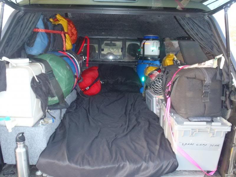
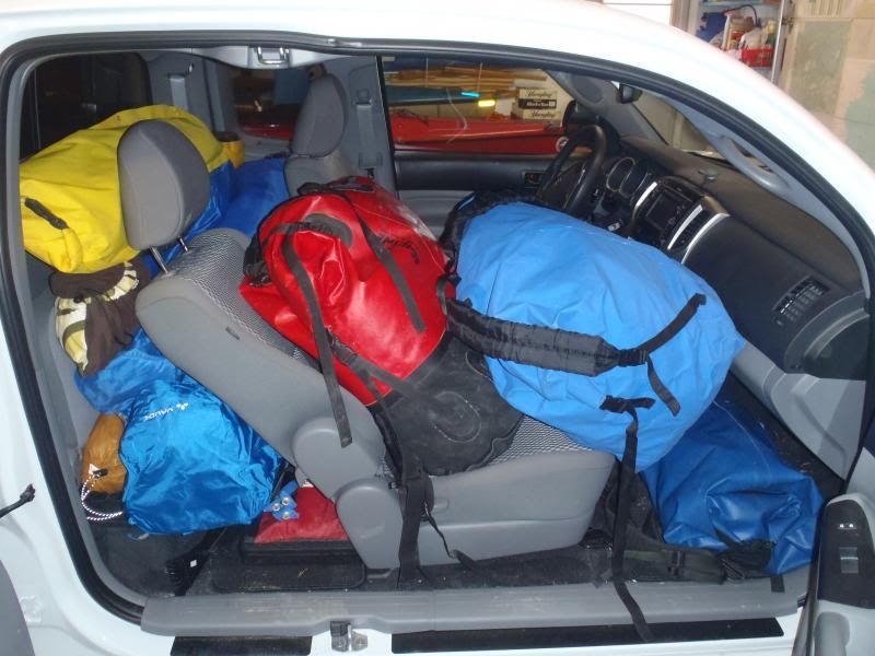
Neither of us cared to pause in flight until we were well west of the Mississippi. The truck, despite containing a mountain of gear, was set up so that we could recline fully in the passenger seat, or move three (later two) strategic dry bags to the front seat and sleep under the cap.


The drive across the plains was windy as heck. It blew 45-50 MPH going across Kansas and Oklahoma, strong enough that we had a hard time opening the truck doors to get out and crank down on the roof rack ropes.

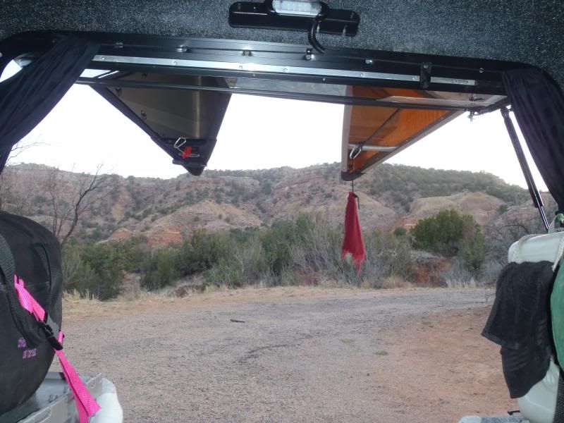
First stop – unplanned, we were freestyling – was Palo Duro Canyon State Park, JUST south of I-27/I-40 in the Texas Panhandle. Palo Duro is the second largest canyon on the US. 120 miles long, 800 feet deep and essentially hidden from sight down in the Texas plains. This was Comanche country (Cheyenne and Kiowa too).

Not especially cheap, with a weird fee structure, but essentially empty and a great place to layover and get into a western state of mind.

NOTE: We were reading the place appropriate chapters of Bury My Heart at Wounded Knee along the way. I highly recommend bringing the non-fiction history of the places you visit.


Palo Duro Canyon State Park
http://www.tpwd.state.tx.us/state-parks/palo-duro-canyon

After a layover day we Blue Highway’ed our way (we had that book along as well) along Rte’s 60 and 70, with a birding stop at Bitter Lake Nat’l Wildlife Refuge. We met a couple of Canadian birders/paddlers there, Gord and Ann Mackenzie. Gord had a Langford Canoe catalog with photos of him paddling on the cover garbed in a Hudson Bay shirt. (Remember that most Canadian of names, it will come up again later).

On to Oliver Lee State Park on the southern edge of White Sands Missile Range for another layover night.

Oliver Lee State Park
http://www.emnrd.state.nm.us/SPD/oliverleestatepark.html

A lovely State Park facility, with great views out over a huge mountain ringed basin. By sheer coincidence the Trinity Test Site was open the next day – the single day it is open to the public this year.

http://en.wikipedia.org/wiki/Trinity_(nuclear_test)

Faced with a purely coincidental opportunity to imagine the end of the world with 10,000 nuke fans in RV’s we opted instead to visit White Sands Nat’l Monument.


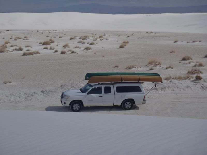
Bizarre place. Joel, in a pattern that would continue for weeks, began planning a future backpacking trip there.

White Sands Nat’l Monument
http://www.nps.gov/whsa/index.htm

Next up, a place that is truly near and dear to my heart, soul and memories – Paradise Arizona, high in the Chiricahua Mountains of SE Arizona
 
Paradise

Paradise

PARADISE ARIZONA (population 5)

http://en.wikipedia.org/wiki/Paradise,_Arizona

Back in 1988 I took a radical sabbatical, roaming the country for 18 months. Several of those months were spent helping friends Dave and Mary Kay build their cabin in Paradise


We are all 25 years older now, and so is the cabin. Just being there brings back a flood of memories, and I remember every mistake we made, including the first window we installed. It was carefully shimmed, trimmed and leveled. It was perfect. Except that we installed it with the window latch on the exterior.

For an amateur effort the cabin is holding up well. The new shed addition is especially nice, probably because I did not help build that part.


Paradise is, well, paradise. It is quiet, unpopulated and dark at night. The views from the cabin windows are supurb.


And the views on the inside are none too shabby either.


There was some funny business with yellow post-it note job lists


And my 40 year streak of never fully completing any project remains intact


The Sky Island mountains of SE Arizona are not the be missed, especially if you are a bird watcher, and the entrance to Cave Creek at Portal is as visually striking a canyon entrance as exists in the west.

There followed eight days in Paradise, including viewing the lunar eclipse from the dark of the deck in sleeping bags, a backpacking trip in the Chiricahuas (for Joel)


Work around the cabin (for me)


And lots of dirt road travel


Too soon it was time to start meandering our way north into Utah. Except for a drop off and pick up shuttle date on the Green River we had left our time unplanned and unscheduled. We had a week left to freestyle the 600 miles between Paradise and Moab.

Let’s make it count.
 
North to moab

North to moab

Paradise to Moab is 600 miles, and 550 of them are along the same scenic blue highway, Rte 191. (which used to be Rte 666 before it was changed for devilish connotations). Up, up and up, into Apache Sitgreaves Nat’l Forest.


Much of the forest burned in the past few years (as did much of the Chiricahuas), but we find an unburned campsite at high elevation, with an Elk herd in the meadow and pockets of snow still on the ground.


It was 27F when we awoke the next morning. I should have brought more fleece and fewer shorts. A good morning to get on the road before breakfast in a nice warm truck and look for a diner along the way.

And a diner we found. A three-calendar diner that offered my favorite breakfast menu selection. I think this one was called “The Lumberjack Special”, eggs, sausage, pancakes and all the coffee you can drink.

North through the Navajo Reservation and into Utah at last. Through Monument Valley


To Goosenecks State Park overlook the S-bends of the San Juan.

http://www.stateparks.utah.gov/park/goosenecks-state-park


Good for a view, and it’s a helluva view, but Joel has something better in mind for a night’s camp. Something much, much better.

Up the Moki Dugway
http://www.midwestroads.com/otherstates/mokidugway/

Three miles of switchbacks that climbs over 1000 ft in 3 miles carved from the side of an escarpment.

Atop the Moki Dugway is Muley Point. Not. To. Be. Missed.

http://www.utahscanyoncountry.com/scenic-vistas.html

My photos cannot do it justice.


Without question the most stunning scenic view of my life, a panorama that included Navajo Mountain, Valley of the Gods, Monument Valley and the San Juan. Not to mention free camping on the slickrock edge of the cliff.


Truly a mind blowing place to view sunset. And sunrise. And to simply sit and ponder the shadows on distant canyon walls change with the sun’s angle, like watching a slow motion movie.

I hated to leave, but we had a recovery mission. During Joel’s 3-week solo hike in Escalante 3 years ago he had left food drops buried in 5 gallon buckets. The buckets are still there.

Let’s just say that was a lot more dirt road (40 miles in, 40 miles out) than I really wanted to travel to pick up a 5 gallon bucket, even though it contained treasures we later used (lithium batteries, drink mixes and sundries).

Recovery complete we headed down the Waterpocket Fold to yet another free and scenic camp, Cedar Mesa in Capitol Reef Nat’l Park.

http://www.nps.gov/care/planyourvisit/primitivecampsites.htm


5 sites, no fees and the people around are our people, hikers, paddlers, birders and wandering explorers; an excellent reintroduction of the human race. Neighbors Rose and Sarah clued us in to an unmarked camp on the Colorado along the scenic route into Moab (Rte 128).

Rose and Sarah are old college friends reconnecting after long absence, as were two gentlemen we met at Muley Point. This will become a recurring theme with folks met along the way.

We would not have found Onion Creek camp along the Colorado without their directions. $5 a night, open roofed pit toilet and a picnic table for staging river gear.


Also a good place to rest up before a three week river trip.


We met the first of four Al’s at Onion Creek, a Wyoming fishing and climbing guide bumming around the desert SW between gigs. Meeting wandering guides would become another recurring theme, as would meeting men named Al.

Next up, we finally get on the river.
 
Wow,

Thanks for the report of your travels. Muley Point gives me yet another reason to return and visit that geography. So much too see in this world.
 
22 days on the green river

22 days on the green river

Last spring on the Green I declared that I wanted to do it again, but longer and slower. Twenty two days to cover 120 miles of river sounds long and slow enough.

We hit Tex’s Riverways the day before our shuttle, paid up the remainder of the bill and spent an afternoon in Moab. Not my favorite town, and paying $176 for a night in a Super 8 motel room and $1.85 a can for Pale Ale didn’t raise it much in my opinion.

Next morning we were at Tex’s, and familiar with the routine. Tex’s has this stuff down to a science; just listen to what Darren or your shuttle driver says, hand them gear they want to load in the trailer as they ask for it and you’ll be on the way in short order. Oh, and show up on time and ready to load, with cash for the balance due, no checks or credit cards. (More on this later, and yes, those instructions are contained in every communication from Tex’s. In bold leters).

Our shuttle driver was Mike (at last a name I can remember). I’ll ride with Mike anytime; he knew his stuff, knew about the places we had been along the way, knew the backpacking routes up canyon from the Green and knew my all-time favorite editor at Paddler, Rico.

This too would be a recurring theme; meeting someone to find that we were on handshake or paddle stroke away. It turned out that we had mutual friends with many of the folks we were to meet along the river.

Launch was at Crystal Geyser (Mile 115.5), accompanied by Bob and Barb in a rental Tex’s Tripper. The first of several Al’s was on the shuttle, also in a rental tripper but insistent on being dropped off at Green River State Park (Mile 120).

HINT – Don’t bother with a State Park drop off, for a number of reasons. Trust me.

Anvil Bottom (Mile 101.5)
The first night’s camp was at Anvil Bottom. Getting there was a challenge, as the wind was blowing 30+ mph, mostly upriver. And, once again, high winds were to become an ongoing theme. Joel keeps telling me that the earth is angry, but it seems especially pissed at him of late.

At one point Joel stopped to adjust his foot brace and I declared that I’d meet him at the end of a small island. I paddled there, and sitting in the swift current the wind blew me back up river. Sorry Joel, gotta go, you’re on your own.

Anvil Bottom was a good reintroduction to the shoe-sucking mud that can accompany sites on the Green.


The site on river right directly across offers a much firmer landing


But it lacks the cottonwood shade and cliff backdrop of Dellenbaugh’s Butte and the Anvil


Next morning the river had dropped a bit, and Joel was up and on the water early. And this too would become a familiar theme; we were travelling on separate permits, and over the course of 22 days only paddled together a few times.
 
Three Canyon/Trin Alcove Bend

Three Canyon/Trin Alcove Bend

Three Canyon/Trin Alcove Bend (Mile 90)
May 24 – 27

Last spring I had ignorantly declared “We got all the best campsites”. I was wrong – Three Canyon may be the nicest site on the river. Anywhere.

As we paddled up the canyon stream we came upon a group taking out - 20 twenty-somethings, 10 guys, 10 girls, 10 rental Grummans. Plenty of tent space in Three Canyon. (Remember that).

Joel set up in his favorite site, well back in the canyon, requiring either a steep haul up a step-cut mud bank or a hundred yard’s thrash along a densely willowed trail. I opted for an easy rock access and wind shelter from the coming storm.


I had printed out the 10-day forecast from Weather Underground, and it looks like another cold front is coming through, with 20-30 MPH winds the next two days, with rain the second day. We’ll sit a couple of days. Joel can hike the three canyons, and I can sit a spell in quite with an empty mind.

Joel’s back-of-canyon site proved to have a ravenous and habituated squirrel population.


He eventually moved camp to join me at the Trin Alcove Café.


The rain came, along with sleet and pea snow (ah to be in the desert in late April)


I wasn’t about to give in to the weather, and donned winter apparel and raingear, playing King Canute, shaking my fist and the shy and shouting “Is this the best you’ve got? Bring it!”


Three Canyon also holds my favorite petroglyph, a necklaced buffalo adorning the wall above a very narrow foothold ledge.


Unfortunately Three Canyon also holds my least favorite rock art, including the words “Duct tape” and “Do you know Jesus?”.

Jesus I wish someone had been on hand with a roll of duct tape when you defaced that wall you moron.

Rant almost over. I don’t know when, in my mind, the cut-off date between historic cowboy glyphs from the teens and twenties, carvings from the early river runners and last year’s idiots in rental Grummans occurred. Not last year. Maybe an inscription of the first rental Grumman.

Three Canyon was peaceful and quiet, even after we were joined by day visitors and an assortment of campers. Well, maybe not peaceful; it blew like stink, and I had to barricade the edges of the fly to reduce windblown dust accumulation.


That would also become a recurring theme, although more elaborate as time and high winds went on.

The river seems far more populated than last spring. We saw 6 boats in 2013 – we’ve seen 30 just in a few days. Visitors included a bizarre mix:

*An inflatable stand-up paddle board, with solo canoe support. Last year we saw a group of four SUP’ers with raft support. I don’t get it. I can think of few craft I would take down this river less suited than a paddleboard.

The guy on the SUP was very good; they left in winds I wouldn’t want to paddle in. I guess, ya know, whatever floats your teensy platform.

*Two (very) small solo rafts, paddled by two very small gentlemen speaking a mix of Spanish (or Portuguese) and Japanese. Seemingly kind of clueless – at one point Joel had to holler “Hey guy, your boat is blowing away: but their behavior would soon be bested.

*Towards dusk a party of three rafts pulled in, or two rafts and a solo cataraft. The leader’s name is Al. Or Al-Two. A retired product designer for North Face. Turns out we have mutual friends (remember, one paddle stroke away…)

The river is akin to a one-way hiking trail – news moves, but only in one direction. Al warns us of a Sierra Club trip headed downriver.

*A Sierra Club trip of a dozen boats. There was serious disgruntlement amongst the group. The trip leader had promised them sandbars, not a one of which was to be found at this water level. The trip leader B--, did not even paddle up into Trin Alcove with the few bold explorers from her group, but waited at the mouth. ISO sandbars. And unicorns.

One of them, after running their rental Pelican (Tag-a-long) into the only boulder in mid-stream, asked me “Are you the hermit of the canyon?”. That seemed a bizarre question, until I realized I was dressed in rags, and dirty rags at that, with a dark brown face and wild beard.

“No, but I’d like to be”

They soon left, still ISO the elusive sandbar, but we were destined to encounter them a few more times.

*And finally, towards the end of the last day, a raft with a couple and two kids. And a pitbull dog. Happy am I; parents adventuring with the family. Good on them.

Or not. The parents strolled back into the cottonwoods to make a distant camp, leaving their kids to play on the bankside 30 feet from our tents.

Their dog was quiet (except when, loose to run, it challenged Joel returning from a hike).

Their loud, unruly and unsupervised kids were not. They yelled, screamed and chanted for hours, all the while destroying the steps cut into the steep bank with implements of destruction from camp. At one point (and only one point) mom walked out from camp to the edge and remarked in quizzical DUH wonder “Weren’t there stairs here before?”.

Remember these folks, they’ll appear again.

The river has been rising, from 7.5 ft when we arrived to 9 ft when we departed. Soon it will be time to mosey along from the spectacle of Three Canyon


Bowknot Bend is 20 miles downstream (27 to the end of the bend) and I would like to get past there even though it will eat up a lot of river miles. There is a 4WD road along river left from Hey Joe Canyon (and the eponymously named uranium mine) all the way along the bend down to Oak Bottom, so somewhere past that. I don’t want to see or hear no steenkin’ vehicles.
 
You need to take more trips and write about them here... I enjoyed it very much! Your story helped me get through some tough times. Looking forward to more.

Cary
 
Horseshoe Canyon

Horseshoe Canyon

Horseshoe Canyon (Mile 45.5)
May 27 – May 30

Up at a reasonable hour, coffee, pack a bit, more coffee and wait until the warming sun is peeking over the high canyon walls. Joel started earlier, with a plan to hike up top at Bowknot Bend.

The wind along Bowknot Bend was howling, and even in the high-water (the river is still rising) I was paddling on the outside curve bubble line for all I was worth and barely moving at times. I passed the Sierra Chubs; they had finally found something approximating a sandbar, a short sandy bluff on river right, camped in a terribly exposed spot amid the wind and blowing sand above Bowknot Bend.

As I came into sight a tandem canoe quickly launched from the site and headed downriver at a race pace, looking I supposed to frontrun me to the next campsite. OK, good luck with that. I may be an old arthritic fat man, but I can still paddle a canoe in high winds.

They toasted me, disappearing so fast I thought they must have pulled off into some side canyon. 5 or 6 miles along Bowknot Bend I found them ashore and slumped over on the bank, breathing heavily. Sorry dudes. Nice try, but wind is my natural element.

Passing around the 7 mile bend I espied Joel atop the knife ridge, waving to me. He shouted something, but the only word I could make out was “CANOE”. I hoped that wasn’t the emphatic word in “MY CANOE BLEW AWAY”.

I was to learn later that the wind nearly blew Joel off the knife edge. I was also to learn that Joel had landed near the Chubs to begin his hike when he heard one of the casually remark “Oh look, there goes one of our paddles”. None of them moved a muscle, so Joel hopped back in his canoe, paddled downstream, retrieved the loose stick and brought it back to their camp. Not the smartest Chubs in the world.

Past Bowknot Bend I didn’t see anything I much liked at Twomile Canyon (Mile 61) and continued on to Horseshoe Canyon (Mile 59).

That was ridiculous mileage for a single day – 31 miles from Three Canyon to Horseshoe canyon – but from here on I’ll slow down my distances. There’s only 59 miles to go and I’ve got 16 days to do it. Go slowly.

Horseshow is differently awesome, with excellent, open 360 degree views in contrast to the close in canyon walls of Trin Alcove. With the Green running high the backwatered canyon creek meanders 30 feet wide for 100 yards to an open sandy bottom. There is not much shade, but there are no other people either. It’ll do just fine.


It even boasts a floral pattern in the bathroom.


It is still very windy, and I’m camped on sand. Time to fully barricade the tent fly.


Not much shade either, so I need to deploy the golf umbrella on the wind chair.


Joel’s plans were to hike Bowknot Bend and Twomile Canyon, so I won’t see him for a day or two at least. I did see the Chubs the next day, or at least one of them, sent into the canyon to scout for campsites. Oh lord please no; having them camped alongside and all around me would be like tenting in a KOA.

My prayers were answered. Despite my assurances that they were welcome to join me and that there was plenty of room they headed on downriver, leaving me once again in blissful solitude and silence.

A few days later I did hear a voice. It was Joel. He didn’t fall off Bowknot Bend (although it was close) and his canoe didn’t blow away (although the 30 mph winds did blow it to the river the bow and stern lines held it).

We camp together for a night and next morning spent an increasingly rare day paddling together. We are permit scheduled to pass Mineral Bottom (Mile 52) today and enter the Nat’l Park. The Chubs are there, awaiting their Tag-A-Long pick up, and Tex’s, by prior arrangement, has left us a 6 gallon jug of drinking water. Not really necessary, as many of the side canyons have good clear filterable water, but we decant 5 gallons in dromedaries anyway.

Waterbags filled we headed downriver to Horsethief Canyon, another of my favorite spots along the river.
 
Your canyon lands trip is... blowing... my... mind. Thanks Mike.
 
I'm really enjoying this trip, from the start, that cabin build was nice, the road trip interesting and I'm learning alot and laughing alot on your trip down the Green.
Looking forward to the next installment, Thanks
 
Horsethief Canyon

Horsethief Canyon

Horsethief Canyon (Mile 45.5)
April 30 – May 2 (or May 3, I lost track of time)

Horsethief had flash flooded since last spring. The upper canyon stream banks are badly eroded, a large cottonwood had come down exactly where Willie’s tent was set up and other cottonwood are root exposed or leaning precipitously.
The ledge site landing is awkward at best, and with the sky again darkening and storm clouds blowing through with the highest winds yet we opted to pull our canoes fully up the ledge and tie them off in the tammies.

But the site is magnificent, with excellent tent sites and a cleft rock for all-day shade.


Joel takes off the next morning. He has hiking plans at Fort Bottom, Tent Bottom and Anderson Bottom/Bonita Bend. I have plans to sit a spell – 46 miles to the confluence and 14 days to do it in. Slow. Down.

I kind of have an idea to camp all of the Horse Canyons - Horseshoe, Horsethief, Deadhorse (Mile 20) and Horse (Mile 14) - but first I’m going to sit for a spell.

Joel and I are travelling on separate permits, and he on a combined permit (paddling and backpacking). We are on very different trips from here on. Joel was engaged in mental calendar gymnastics, trying to figure out a hike for every day, moving camp a few miles at a time. I was engaged in emptying my mind of all but birdsong, sun & shadows on the cliff walls and the feel of the wind in my beard.

I’ll two or three night camp every site from here down and have no idea where I’ll be stopping when I do. Eventually some site with clean filterable water, but I have 20 liters still in the dromedaries.

I find that I am superbly comfortable in the environment. Much of my home time is spend paddling the edges of the Chesapeake Bay and mid-Atlantic barrier islands, and the techniques for dealing with sun exposure, wind and blowing sand carry over nicely.

I am eventually joined by neighbors. I invited them to share my site if they liked, but they camped on the sandy plateau at back of the canyon. A group of six from Bozeman; four in a Tex’s catamaran Grumman rig (unwieldy) and two in solo boats.


They were quiet, respectful and good company when they came to visit. I was disappointed to hear that they had tried to camp in Three Canyon/Trin Alcove but were dissuaded when I woman came down to the bank and told them there was no room.

A woman with a raft, and a husband, and two kids and a pit bull dog.

OK, I was beyond disappointed. I was pissed. “No room” my arse. Someone failed their kindergarten lesson in sharing.

I hope to linger at Horsethief for several days. Friend Willie is on a trip that put in a week ago and is due to pass Mineral Bottom tomorrow, likely stopping to camp at Horsethief. It turns out the neighbors were on the same shuttle with Willie and company. They headed out the next morning and I once again had utter quietitude.

Perfect silence, broken only by the sound of canyon wrens in the willows and the Zzzzzz of hummingbirds. I expect that will change when Willie and company arrive. The neighbors had mentioned that on their shuttle ride one of Willie’s companions “Never stopped talking”.

I thought I heard Willie and company several times, but it was only a swarm of bees, and later a gnarl of flies contesting a piece of lizard crap.

Perfect quiet until an eerie “Crack…creak…crack…snap”, followed by a thunderous CRASH as one of the undercut cottonwoods came crashing down. It didn’t land on my tent or gear, so it was entertaining and not catastrophic.

I honestly do not know how many days I spent in silence at Horsethief. Long enough to lose track of the date. Long enough to get to recognize individual lizards – Longtail, Fatty, Headbobbing Bob and Stubby – but eventually it was time to pack it up and move along


I do no especially want to camp at Fort Bottom (Mile 40). If Anderson Bottom/Bonita Bend (Mile 31) is open I’ll stop there, camp and filer water from the spring. Beyond that I want to check out Holeman Canyon (Mile 28) and Soda Springs Canyon (Mile 21.5).

Turks Head (Mile 21) and Deadhorse (Mile 19.5) are too far along. I don’t need to put in a 25 mile day. Slowly, go slowly.
 
Deadhorse Canyon

Deadhorse Canyon

May 4[SUP]th[/SUP] (or 3[SUP]rd[/SUP], or 5[SUP]th[/SUP]) was a bizarre day on the river. Warm (at last), sunny and only a little breezy (at first, then it blew like stink once again).

I got another late start. Despite the dawdling launch I passed several canoes along the way and arrived to find Anderson Bottom heavily occupied. I don’t need to filter water that badly, and really don’t need to hear a babble of voices, so I kept going.

Holeman Canyon at Mile 28 had nothing, not even a break in the tammies. An unnamed canyon at Mile 25 likewise. Soda Springs Canyon at Mile 22 had nada. The ledge site at Turks Head was occupied by my Bozeman neighbors, and although I knew they would welcome me that site was tight last year with just 4 tents.

On to Deadhorse at Mile 20.

There are two gentlemen camped at a tiny, tight site at the mouth of Deadhorse Canyon. They hail me as I paddle in and, when I ask about camping further up in the canyon, one replies with an oddly hesitant “Wellll, you can go have a look…”

I’ll do that. There are four or five boats beached on the gravel bar at the head of the canyon, where it opens up into a massive bowl shaped wash fringed by cliffs. A Tex’s Grumman or two, a couple of cheap rec kayaks and an ancient Blue Hole. Most of the gear is still in the boats, in garbage bags and plastic storage bins, the rest is scattered hap hazardously in the wash.

As I’m securing my canoe a middle aged guy walks up with a scowl.

“Hi, sorry to disturb you, I’m just looking to see if there is room for a solo tent back here”

He folds his arms, looks pissed and replies “Nope, no room back here”

I give a quizzical look over his shoulder at the acres of open ground behind him and he move to block the trail and glares at me. He is itching for a confrontation and the old redneck deep within me begins to boil.

We had a tense little standoff while I decided which way the day was going to go, and eventually my desire for peace overcame my urge put him face down in the dirt. I fingered the rescue knife on my vest and called him a Di@$head in the most dismissive and disgusted tone I could muster. That seemed a derogatory with which he was familiar, and he didn’t press the issue.

I paddled on in search of a better and kinder world.

It was getting long in the day. I’d come further than I wanted and would like to find a place, any place, to spend a night.

Unnamed canyon at Mile 18.5 - Nothing
Unnamed canyon at Mile 17.5 - Nothing
Unnamed canyon at Mile 16.5 - Nothing
Unnamed canyon at Mile 15.5 – Nothing

Well dammit, its Horse canyon for better or worse. I don’t care if it is populated by refuges from Wrestlemania, I’m camping there.
 
Your trip reports really cut into my workday. In a good way. A very good way. Thanks.
 
Horse Canyon

Horse Canyon

Horse Canyon (Mile 14.5)
May 4 – May 10

I felt some trepidation as I paddled into Horse. The stream back was long at high water and I was praying for a vacancy, or at least a kindly reception.

Empty. No one. Not a soul.

Stunning views, deep within a twisty S turn canyon. Deep shade. Absolute silence.

I was too bushed to move gear very far, and with clear skies chanced setting up camp for the first night on the next to last ledge of the dry wash.


The Horsethief to Deadhorse to Horse ate up another unintentional 31+ miles. I’m here for a long spell. Which is good, because Horse is perfect.

The next day I moved tent from risky wash to a high and safe plateau, set up the parawing and find a spot with a view for the toilet.


There is a cold, clear seep pool from underground at the edge of the highwater and although I am sure there is freshwater at the back of the canyon I filter first from there.


It is only 14 miles to the confluence, and Joel starts a 4-day backpacking trip into the Maze just a mile or so above the entrance to Horse Canyon. The earliest I expect to see him out of the Maze is, um, crap, I’ve lost track of days even with daily calendar notations, four days from now? Five?

I really would like to see him out of the Maze. I’m here for the duration.

The morning calm gave way to insane winds. Although the parawing was secured with mil-spec stakes triangulated at all four corners I added an additional line at the low ends. And then had to pile 50 lbs of rocks atop the stakes.

It blew 30-35 and gusted higher. The wing did its catenary cut thing, windward side billowed in, back side billowed out, spilling air. Even so I was certain that a line would snap, a pole bend or the wing simply fail at the seams.


It held for the duration, and kept me out of a bit of blowing sand. I love that wing in the wind.


Speaking of blowing sand – the tent barricading reached its final and most elaborate stage.


I will quote Kelsey on Horse.
http://www.amazon.com/River-Guide-C...00&sr=1-1&keywords=river+guide+to+canyonlands

“Just below Mile 15 is a drainage coming down and out of Murphy Canyon and Basin, but there a big dryfall a ways back from the river. Since this drainage is fairly long and covers a large area it sometimes has big floods.

From the river you can walk up Horse Canyon about 1km. It’s very deep and entrenched at the lower end. After about a km you’ll come to a big dryfall, and probably a plunge pool below. If you’re there not long after a big storm this will be an Olympic sized swimming pool”

Note: I edited the above for the sake of syntax, sense and readability. Kelsey’s book’s, all 17 of them, are self-published, and proofread but apparently not edited. They are an amazing font of detailed information, but it is presented in a jumbled and disorganized fashion as he rambles from topic to topic, eventually arriving at the oft repeated phrase “So, anyway, back to the river….”

He desperately need a good editor. Up the canyon I go.


Oh heck yeah!


The dryfall


The pool


Back at camp I find the river level dropping. The gravel bottomed is perhaps a 1% grade. I had secured the canoe in the tammies at the water’s edge, and tied off a Duckhead flag there to catch Joel or Willie's attention. The canoe and flag are now 100 yards from the water.


It may be a long walk out of here.

Words about water: I started at Crystal Geyser with two full 10L dromedaries and 2 canteens. Three Canyon had good filterable water. Tex’s left us 6 gallons at Mineral Bottom. Anderson Bottom had good water is I’d cared to stop. And Horse has an ample supply at the bottom of the dryfall.

I spend most of my following days watching the ravens. One buzzed me twice, first coming in on a glide path near my head from the front, and then turning to nearly graze the top of my head from behind. I do love the sound of a raven’s wings in flight, and the local pair often make for their favorite perch along the canyon wall to nuzzle and coo at each other. Somebody’s getting some tonight.

The peregrine falcons stick to the top of the canyon and the tamarisk beetles slowly make their way through (to them) Everest-sized footprints in the sand.

It doesn’t get any better than this.


I take to settling a 5-gallon bucket of river water with alum every day. Wash some clothes, wash some me, wash some other people.

I had visitors thrice. A young couple in a rental Grumman I had passed earlier on the river, Joel and Mel. They hiked up to the dryfall and back before continuing on, but did me various favors during their short visit.

Mel had a watch with a date function. I should get me one of those. I was off by a day. Joel gave me a printed 10-day Weather Service through the remainder of the week. They had seen Joel’s kevlar Rendezvous on the banks a mile up river, so I knew he was out in the Maze.

I sent river-news about my location with them in case they later saw Joel or Willie’s group.

A quiet day later Alex, Barry and Bruce arrived. Alex is the owner of Stewart River Boatworks
http://www.stewartriver.com/

Once again, we find we are one paddle stroke away. They were great fun. One of them remarked to me “I don’t have a sophisticated Pale Ale wind barrier for my tent”.

Each of them washed up with the day’s silt settled bucket of alum water. And each said the same exact thing on toweling off – “I feel like a new man”

I was to provide bathing water for a half dozen people this trip. Unfortunately not once did I hear “I feel like a new woman”.

The bourbon came out that night, and each allowed that would have a sip. Then the fire-in-a-can came out and before we knew it the whisky was running low and the hour late.

Bruce was a Lutheran minister, but I’m sure he has Irish blood. He had a wry sense of humor, a quick comeback and that happy tinkle in his eye. Well met Bruce, I’d share a camp with y’all anytime.

Last camp companions, after another day or two of solitude, were Todd and Bill, a couple of paddlers from Ontario. Turns out Todd has work with Langford Canoe, and with Swift. He designs custom truck racks. He knows Gord Mackenzie (remember him?).

One amazing paddlestoke away from everyone.

Todd is also a recent retiree, and is strategizing the fit out of a Toyota Tacoma as a travelling truck. That went late into the night, and I pretty much burned out the fire-in-a-can and bricks of feeder wax.

They departed the next day, leaving me again to endure the crushing silence, broken only by birdcalls. Someone’s gotta do it.

With my knowledge of the day’s date corrected I was back on track. Willie’s take out day at the confluence came and went, so I wouldn’t be seeing them. Joel’s backpacking permit expired, and I sure hope to see him again someday, it’s been over a week.

The water began slowly returning up canyon as the Green rose again. A good thing; Todd and Bill had told me of a low-water mud bar that was forming at the mouth of the canyon, which they had difficulty passing over. That may account for the paucity of people paddling back into Horse Canyon.

I had earlier moved my canoe 100 yards closer the water. Awaking on the morning of my departure I found that the water had come back in 100 yards. Or more, it was higher than when I arrived and necessitated a knee deep wade to fetch my canoe.

I’ll have plenty of water to get over the bar. It’s like it was meant to be.

And little did I know that the best was yet to come.
 
Last edited:
A further note on Horse Canyon and Weather Forecasting

A further note on Horse Canyon and Weather Forecasting

Visitors Joel and Mel had given me a current print out of a 10-day forecast. I played that knowledge for everything I could in front of Alex, Barry and Bruce, leading them to believe that I had an uncanny natural ability to predict the weather.

I would occasionally sneak a look at the detailed forecast folded in my shirt pocket and glance at the sky before intoning things like “Feel that change in baraometer? There’s a cold front is coming through, it’ll probably drop in the 40’s tonight, Mid-70’s tomorrow, and breezy”

Yup, I can feel it in my trick left knee.

I sold it so completely that I had to fess up as they were leaving, handing Alex the printed forecast from my pocket. I’m not sure he found it as amusing as I did.
 
Shot Canyon

Shot Canyon

Shot Canyon (Mile 4.5)
May 10 – May 14

I paddled out of Horse Canyon after nearly a week’s repose with plenty of water to pass the bar. In fact the highest water level yet. There are folks camped on a fast shrinking sandbank a mile downstream, who must have had a sleepless night with the river’s rise. There are folks at Jasper Canyon (Mile 9.5) more at Stove Canyon (Mile 7).

The water is high and nearly all of the sandbar camps are submerged. The occasional bankside path through the tammies affords neither eddy nor convenient landing. The high and swift water has forced everyone into the same ledge and canyon sites.

I sure hope there’s space at the ledge site above Shot Canyon. I know every site I stay in is deemed “One of my favorites”, but that one truly is. (And will become much more so in the days to come).

There is someone on the Shot Canyon ledge. It is Joel.


I haven’t seen Joel in 9 days. He has had his own one-paddle-stoke-away experiences. The two guys he camped with last night are from Baltimore; they went to Landsdown High School when Joel’s mother taught there.

He also has river news – Willie had a saw accident and evacuated out the White Rim Road. Joel had seen the impassible mud bar at the mouth of Horse and kept going, later learning through the river grapevine that I was camped far back in the canyon, and as far as he knew had been stuck to my shoulders in mud at the entrance, hoping that the river don’t rise.

I was likewise concerned that he was dead under some rockfall, pulling a later day Everett Ruess
http://en.wikipedia.org/wiki/Everett_Ruess

I am under fairly specific instructions to leave him where he lies, especially if that is back in Escalante or the Maze district. Or the Needles. Or pretty much anywhere scenic and remote. Always good to see Joel after a long absence.

The following afternoon it clouded up under darkening skies and we put up the wing. And no sooner did we have it fully staked out than a group of 7 arrived. And what a group of 7.

Three rental Grummans. Three couples. Two of the women are visibly pregnant. The 7[SUP]th[/SUP] member of their party is a 2 ½ year old. The child, Tep, was the most surefooted toddler I’ve ever met. They are climber and are toting ropes, helmets and gear.

Oh heck yeah, stay here, we’ll take the tarp down and make room. Fitz, Jake, Dave, Emily, Becka and, oh dang, I forget. They needed a few things beside space. Tent stakes for one; we loaned them the ones from the tarp when we took it down to make space. And a laminated map of the up-canyon route they were planning to hike.

It rained that night. It rained hard and I boo hooed about not being able to catch buckets of freshwater off the low end of the ‘wing. The drumming of rain on the tent was suddenly – and I mean instantaneously – replaced by a thunderous roar.

The cliffs behind camp became a waterfall. Fortunately all of the tents are high and dry, but two waterfalls and streams are flowing from the cliff walls through camp.

Even louder than the roaring falls there is another noise. The climber’s rental canoes are tied to the tammies and floating in the water. Well, tied to a single slender tammie, all three of canoes. And that slender tammie is now underwater in the fast rising river.

Joel awakes (or perhaps never really sleeps) to the sound of crashing boats and goes out to investigate. Just in time to see a 30 foot log careen downriver and smash their canoes. In the pouring rain he gets out spare rope, pulls their boats out and ties them securely.

Only Joel.

The next morning we awake to find another iffy day, with clouds that portend more rain. We set the wing back up on a non-tentable slope. In the nick of time, it begins to rain again.

And oh, what a rain. Waterfalls began to appear, pouring over the canyon rim. Waterfall after waterfall. One, two, three, four, five, six, until there were seven in view, scattered at every pint of the compass, so that no matter which way you turned several were in view.

All different. Some streaming straight off the rim 1000 feet above in a Bridal Veil mare’s tale


Some that gushed out of cracks and crevices 100 feet down from the rim


The one behind (and though) the ledge site camp was the coolest of all. A series of four separate waterfalls, separated by higher ledges and plateaus.


Each lower basin took 20 minutes to fill, and by the time the last falls at camp was running the sun was peeking through.


The climbers were in their natural element, sheltering below a covering ledge, happy as could be, occasionally sticking out a cup or bowl to wash in the waterfall.


This I thought was a once in a lifetime phenomenon. Something I was blessed to see this one time and never again. No question in my top three tripping experiences, along with a northern lights show over Lake Superior in the 80’s and the Leonid meteor storm of 2001.

Absa-freaking-loutely amazing.

And then it rained and happened again.

And later that evening, again. Grok this.

During that last evening shower a wet woman arrived in camp, looking for a place to set up. There is maybe room for a single small tent, if the climbers move their toilet.

We invite her to have a look around and stay if she likes, but it turns out there are 6 tents in her party of mostly New Mexicans. Much as I like NM folk there simply isn’t room.

About then the rest of her group struggles up to camp and everything changes. Some were blue lipped, teeth chattering and shivering uncontrollable. Seriously hypothermic.

Joel and I went into rescue mode. We got them under the tarp, out of their wet cloths, pack-toweled dried and started throwing hot chocolate and Milky Ways at them to fuel the furnace. A couple were not in good shape, and we bundled Janet in Joel’s underquilt, dressed her in my raingear and plopped her in the insulated wind chair until her extremities were warm.

No space? Watch this!

Joel’s narrow tent slot turned became a triplex


Max’s tent overlapped mine at the fly (He snores. So do I). The bathroom became a two seater.


Once warm, dry, rested and safe they were among the finest people met on this or any other trip. And, again, several of them proved to be but a single paddle stroke away.


Once thawed out Janet, yet another grey haired ex-raft guide, was simply adorable. There’s something about ex raft guide babes. She is a diminutive woman, and dressed in my oversize Goretex looked like the wife of Freddy the Freeloader. (How old does one have to be to get a Red Skelton reference?)


Some of their tents were wet from a rainy morning take down. We had a spare interior ground cloth. Nancy had been sleeping on a leaking Thermarest since the start. Joel inflated his spare Big Agnes pad.

There followed one of the most memorable nights on the river in 3 weeks. They were great folks, funny, wry and slightly sarcastic, knowledgeable and experienced. As we lazed under the tarp at sunset Emily from the climber group brought us a pot of vegan stew.

Vegan stew? Seriously?

It was as good as anything I’ve eaten in my life. I may have to rethink my opinion of the whole vegan thing.

She also told us that her party had begun referring to Joel and I as “The Fairies of the Canyon”. I took that with the best possible connotation.

Amidst the evening rainstorm yet another group arrived, the strangest yet. A group of 5 young backpackers, come overland through the Maze, toting massive packs containing inflatable solo rafts. They took one look at the tenement-like sleeping conditions, inflated their rafts and were soon launched and floating downriver in the rain.

Ah, to be 20 again. Joel of course now wants to do just that. Hey Joel, you are 53, not 20.

We saw our new New Mexico friends off the next day, and the climbers as well, and settled in to await more company. Shot and Water Canyons are the next to last possible stop before the confluence, and two more visitors did arrive.

Phil and Rebecca. Phil is…. ok guess…. a raft guide in British Columbia, and he’s packing a mandolin. Rebecca is likewise from BC. Her best friend’s uncle – seriously, I couldn’t make this stuff up – was my boss and mentor for the first decade of my career. One paddle stroke away. Again.

They are planning to hike to the confluence overlook. Phil’s only footwear is a pair of Crocs and Joel, having done that hike a time or two, is concerned for his safety. Joel offered his hiking boots, but Phil is a size 12 and Joel has teeny mountain goat feet.

I’m a size 12, but have only a worn out pair of Wal-Mart tennis shoes. At least my shoes made it to the top of the rim. Fairy shoes.

Later, as Joel is ensconced in the cliffside, playing banjo and guitar, a passing group hails him from the river.


They are on far river left and call out “Hey, is this Jasper Canyon?”

Joel shouts back “No, this is Shot Canyon”

“Where is Jasper?”

“You passed it 5 miles ago”

That communication passed they continued to float down canyon, probably still unaware of their location beyond “Somewhere in Utah”


Why are they paddling on far river left when looking for Jasper Canyon on river right is a mystery, at least until Phil and Rebecca return. The Clueless Boys had been on their shuttle.

They are a group of four old college buddies, reuniting on a river trip. They showed up late at Tex’s (actually they called for directions when they were already late) and barely had sufficient cash amongst them to pay their shuttle balance - this despite every single communication from Tex’s stating in big bold highlighted letters “THE BALANCE OF YOUR TRIPIS DUE ON LAUNCH DAY. WE DO NOT ACCEPT PERSONAL CHECKS ON LAUNCH DAY. WE DO NOT ACCEPT CREDIT CARDS. PAYMENT IN CASH OR TRAVELER’S CHECKS”.

They had nothing ready when they arrived late at Tex’s. Their gear was in cardboard boxes, went onto the shuttle trailer that way and was loaded into trash bags at the launch. For a map they had a copy this:

http://www.texsriverways.com/pdfs/rivermap.pdf

God protects fools and little children.

Hearing this tale I suggested that Joel should have shouted to them to go 4.5 miles are turn left at the big T-intersection. At least that would have assured that they didn’t F-up and blunder down Cataract Canyon.

As if to offset this cluelessness another party arrived, 5 in two rental tandems and a rental kayak. On learning that they planned to land and head out on a backpacking trip into the Maze from Shot Canyon they were so respectful of our privacy that I had to practically beg them to come ashore (the trail up canyon starts right in camp).

They were wonderful to watch in action. Coordinated and efficient, they chain ganged a ton of gear onto a site, hauled their rental boats far up onto the ledge, had lunch, assembled their backpacking gear and were off hiking in expeditious order. dang fine organization, and they gave Joel and I each a cold beer when as they left.

I’d been out of beer for a few days. Well, not out, I had the traditional “Trophy Beer” remaining, the last beer I try to take home from every trip as proof of proper planning, to be inscribed with the place and dates and set in honor on the shelf of dusty and aging trip beers. Each can has a tale to tell.

I’m almost done. We just need to catch Tex’s Jet Boat upriver to Potash, ride the shortbus to back to Moab, repack the truck and start heading east.
 
Very entertaining! But how did you extract revenge on the guy from Deadhorse? I know the nature of your soul and though you bore his denial of access, the best you could. We both know, the "Hermit Fairy of the Canyon", at length, would be avenged. Please tell us more, is the craphead entombed in the walls of the canyon, has he become the later day Everett Ruess? In pace requiescat!
 
Last edited:
Back
Top